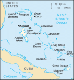
The Bahamas, officially the Commonwealth of The Bahamas, is a country within the Lucayan Archipelago of the West Indies in the Atlantic. It takes up 97% of the Lucayan Archipelago's land area and is home to 88% of the archipelago's population. The archipelagic state consists of more than 3000 islands, cays, and islets in the Atlantic Ocean, and is located north of Cuba and northwest of the island of Hispaniola and the Turks and Caicos Islands, southeast of the U.S. state of Florida, and east of the Florida Keys. The capital is Nassau on the island of New Providence. The Royal Bahamas Defence Force describes The Bahamas' territory as encompassing 470,000 km2 (180,000 sq mi) of ocean space.

The Bahamas are a group of about 700 islands and cays in the western Atlantic Ocean, of which only between 30 and 40 are inhabited. The largest of the islands is Andros Island, located north of Cuba and 200 kilometres southeast of Florida. The Bimini islands are to its northwest. To the North is the island of Grand Bahama, home to the second-largest city in the country, Freeport. The island of Great Abaco is to its east. In the far south is the island of Great Inagua, the second-largest island in the country. Other notable islands include Eleuthera, Cat Island, San Salvador Island, Acklins, Crooked Island, and Mayaguana. Nassau is the capital and largest city, located on New Providence. The islands have a tropical savannah climate, moderated by the Gulf Stream. The total size is 13,878 km2 (5,358 sq mi). Due to the many widespread islands it has the 41st largest Exclusive Economic Zone of 654,715 km2 (252,787 sq mi).
The Lucayan people were the original residents of the Bahamas before the European conquest of the Americas. They were a branch of the Tainos who inhabited most of the Caribbean islands at the time. The Lucayans were the first indigenous Americans encountered by Christopher Columbus. Shortly after contact, the Spanish kidnapped and enslaved Lucayans, with the genocide culminating in complete eradication of Lucayan people from the Bahamas by 1520.

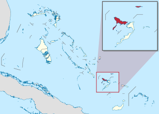
Andros Island is an archipelago within the Bahamas, the largest of the Bahamian Islands. Politically considered a single island, Andros in total has an area greater than all the other 700 Bahamian islands combined. The land area of Andros consists of hundreds of small islets and cays connected by mangrove estuaries and tidal swamplands, together with three major islands: North Andros, Mangrove Cay, and South Andros. The three main islands are separated by "bights", estuaries that trifurcate the island from east to west. It is 167 kilometres (104 mi) long by 64 km (40 mi) wide at the widest point.

The Abaco Islands lie in the northern Bahamas. The main islands are Great Abaco and Little Abaco. There are several smaller barrier cays, of which the northernmost are Walker's Cay and its sister island Grand Cay. To the south, the next inhabited islands are Spanish Cay and Green Turtle Cay, with its settlement of New Plymouth, Great Guana Cay, private Scotland Cay, Man-O-War Cay, and Elbow Cay, with its settlement of Hope Town. Southernmost are Tilloo Cay and Lubbers Quarters. Another of note off Abaco's western shore is Gorda Cay, now a Disney-owned island and a cruise ship stop renamed Castaway Cay. Also in the vicinity is Moore's Island. On the Big Island of Abaco is Marsh Harbour, the Abacos' commercial hub and the Bahamas' third largest city, plus the resort area of Treasure Cay. Both have airports. A few mainland settlements of significance are Coopers Town and Fox Town in the north and Cherokee and Sandy Point in the south. Administratively, the Abaco Islands constitute seven of the 31 Local Government Districts of the Bahamas: Grand Cay, North Abaco, Green Turtle Cay, Central Abaco, South Abaco, Moore's Island, and Hope Town.

Exuma is a district of The Bahamas, consisting of over 365 islands, also called cays.

Ragged Island is a small island 23 km2 (8.9 sq mi) and district in the southern Bahamas. Ragged Island is part of the Jumentos Cays and Ragged Island Chain. The crescent-shaped chain measures over 180 km (110 mi) in length and includes cays known as Raccoon Cay, Hog Cay and Double-Breasted Cay. Island ownership is stated to have been granted to William George Lockhart some time in the 1700s. On 8 September 2017, Duncan Town took a direct hit from Hurricane Irma.

Acklins is an island and district of the Bahamas.
Crooked Island is an island and district, part of a group of Bahamian islands defining a large, shallow lagoon called the Bight of Acklins, of which the largest are Crooked Island in the north and Acklins in the south-east, and the smaller are Long Cay in the north-west, and Castle Island in the south.

Samana Cay is a now -uninhabited island in the Bahamas believed by some researchers to have been the location of Christopher Columbus's first landfall in the Americas on October 12, 1492.
Long Cay is an island in the Bahamas in an atoll that includes Acklins Island and Crooked Island. It is 8 square miles and is in the Acklins and Crooked Islands District. As of 2010, its population was 29.
The Cat Cays are two islands in the Bahamas, North Cat Cay and South Cat Cay, approximately 10 miles (16 km) south of Bimini. North Cat Cay is a privately owned island and is run as a private members club by the Cat Cay Yacht Club. South Cat Cay is currently under development.
The following outline is provided as an overview of and topical guide to The Bahamas:

The following is an alphabetical list of topics related to the Commonwealth of The Bahamas.
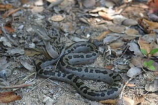
Chilabothrus chrysogaster, commonly known as the Turks Islands boa or the Southern Bahamas boa, is a species of snake found in the Southern Bahamas and the Turks and Caicos Islands. Local names include rainbow boa, Bahamas cat boa, rainbow snake, and fowl snake. Like all boids, it is not a venomous species.
The Bahamas is a net importer of food, importing almost 90% of its food supply. Of food imports, 80% are from the United States.
Pineapple Air is an airline based in Nassau, Bahamas.

Hurricane Joaquin was a powerful tropical cyclone that devastated several districts of The Bahamas and caused damage in the Turks and Caicos Islands, parts of the Greater Antilles, and Bermuda. It was also the strongest Atlantic hurricane of non-tropical origin recorded in the satellite era. The tenth named storm, third hurricane, and second major hurricane of the 2015 Atlantic hurricane season, Joaquin evolved from a non-tropical low to become a tropical depression on September 28, well southwest of Bermuda. Tempered by unfavorable wind shear, the depression drifted southwestward. After becoming a tropical storm the next day, Joaquin underwent rapid intensification, reaching hurricane status on September 30 and Category 4 major hurricane strength on October 1. Meandering over the southern Bahamas, Joaquin's eye passed near or over several islands. On October 3, the hurricane weakened somewhat and accelerated to the northeast. Abrupt re-intensification ensued later that day, and Joaquin acquired sustained winds of 155 mph (250 km/h), just short of Category 5 strength.

The Bahama Archipelago, also known as the Lucayan Archipelago, is an island group comprising the Commonwealth of The Bahamas and the British Overseas Territory of the Turks and Caicos Islands. The archipelago is in the western North Atlantic Ocean, north of Cuba along with the other Antilles, and east and southeast of Florida. The archipelago has experienced the effects of at least 22 Atlantic hurricanes, or storms that were once tropical or subtropical cyclones, including 17 since 2000. The storms collectively killed 101 people.