Tanzania comprises many lakes, national parks, and Africa's highest point, Mount Kilimanjaro. Northeast Tanzania is mountainous, while the central area is part of a large plateau covered in grasslands. The country also contains the southern portion of Lake Victoria on its northern border with Uganda and Kenya.

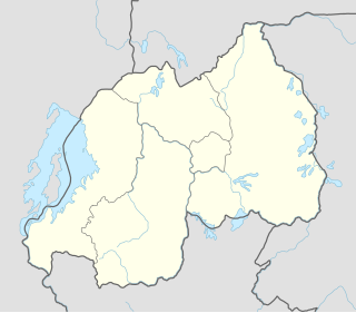
Rwanda is located in central Africa, to the east of the Democratic Republic of the Congo, at the co-ordinates 2°00′S30°0′E.

Cyperus papyrus, papyrus, papyrus sedge, paper reed, Indian matting plant or Nile grass, is a species of aquatic flowering plant belonging to the sedge family Cyperaceae. It is a tender herbaceous perennial, native to Africa, and forms tall stands of reed-like swamp vegetation in shallow water.

The Sudd is a vast swamp in South Sudan, formed by the White Nile's Baḥr al-Jabal section. The Arabic word sudd is derived from sadd (سد), meaning "barrier" or "obstruction". The term "the sudd" has come to refer to any large solid floating vegetation island or mat. The area which the swamp covers is one of the world's largest wetlands and the largest freshwater wetland in the Nile basin.

The Ruzizi is a river, 117 kilometres (73 mi) long, that flows from Lake Kivu to Lake Tanganyika in Central Africa, descending from about 1,500 metres (4,900 ft) to about 770 metres (2,530 ft) above sea level over its length. The steepest gradients occur over the first 40 kilometres (25 mi), where hydroelectric dams have been built. Further downstream, the Ruzizi Plain, the floor of the Western Rift Valley, has only gentle hills, and the river flows into Lake Tanganyika through a delta, with one or two small channels splitting off from the main channel.

The Kagera River, also known as Akagera River, or Alexandra Nile, is an East African river, forming part of the upper headwaters of the Nile and carrying water from its most distant source. With a total length of 597 km (371 mi) from its source located in Lake Rweru in Rwanda.

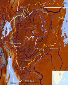
The Albertine Rift is the western branch of the East African Rift, covering parts of Uganda, the Democratic Republic of the Congo (DRC), Rwanda, Burundi and Tanzania. It extends from the northern end of Lake Albert to the southern end of Lake Tanganyika. The geographical term includes the valley and the surrounding mountains.

The wildlife of Burundi is composed of its flora and fauna. The small, landlocked country is home to 2,950 species of plants, 596 birds, 163 species of vertebrates, 52 species of reptiles, 56 species of amphibians, and 215 fish species. The wildlife has been drastically reduced in recent years, mainly on account of intense population pressure, conversion of large areas of forest into agricultural land, and extensive livestock farming. The protected area encompasses little more than 5% of the total area of the country.
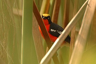
The papyrus gonolek is a species of bird in the family Malaconotidae. It is found in Burundi, Democratic Republic of the Congo, Kenya, Rwanda, Tanzania, and Uganda. It has specialised habitat requirements, being restricted to papyrus swamps. Not yet a threatened species, it has become rare due to habitat loss and pollution.

The wildlife of Rwanda comprising its flora and fauna, in prehistoric times, consisted of montane forest in one third the territory of present-day Rwanda. However, natural vegetation is now mostly restricted to the three National Parks and four small forest reserves, with terraced agriculture dominating the rest of the country.
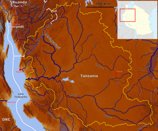
The Malagarasi River is a river in western Tanzania, flowing through Kigoma Region, although one of its tributaries comes from southeastern Burundi. It is the second-longest river in Tanzania behind the Rufiji—Great Ruaha, and has the largest watershed of any river flowing into Lake Tanganyika. The Malagarasi-Muyovozi Wetlands are a designated a Ramsar site. Local tribes have nicknamed the Malagarasi as "the river of bad spirits".
The Nyabarongo is a major river in Rwanda, part of the upper headwaters of the Nile. With a total length of 351 km (218 mi) the longest river entirely in Rwanda. It is extended 421 km (262 mi) in Lake Rweru including a 69 km (43 mi) upper course of Kagera River before joining into Ruvuvu River to form the Kagera River. The river begins its course at the confluence of the rivers Mbirurume and Mwogo in the South West of the country. These two rivers themselves begin in Nyungwe Forest, and are considered by some to be the most distant source of the Nile. From its start, Nyabarongo flows northward for 85 km, and forms the border between the Western and Southern Provinces. At the confluence with the river Mukungwa, the river changes course and flows eastward for 12 km, then to a more South Eastern course for the last 200 km. For the longest stretch of this course, the river serves as the boundary between the Northern and Southern Provinces, then between the City of Kigali and the Southern Province, and lastly between the City of Kigali and the Eastern Province.
The Rugezi Marsh is a protected area in Rwanda, covering 6,735 hectares. The wetland is one of headwaters of the Nile, situated in the Northern Province within the Buberuka Highlands. At 2,100 metres (6,900 ft), the marsh is a high altitude peat bog. Rugezi developed from an accumulation of organic materials within a quartzite rock-trapping water depression. In its natural state, Rugezi has been playing a significant ecological, hydrological, socio-economical, historic, and recreational role in Rwanda. It is also an Important Bird Area (IBA) recognized by the BirdLife International in 2001, and is reported to be the habitat of 43 species of birds within and in the surrounding areas of the marsh; the area of IBA is identified as ha8,500 hectares. The specific species of Grauer's swamp warbler and white-winged swamp warbler living together is reported as "unusual" by BirdLife International.

The Rukarara River is a river in western Rwanda that is a tributary of the Mwogo River, in turn a tributary of the Nyabarongo River. It is the most distant headwater of the Nile.

Lake Mugesera is a lake in the Eastern Province, Rwanda.

The Mwogo River is a river in western Rwanda that is a tributary of the Nyabarongo River.
The Mbirurume is a river in western Rwanda that is a tributary of the Nyabarongo River.

Lake Burera or Bulera is a lake of northwestern Rwanda, at the border with Uganda. With an area pf 55 km2 (20 sq mi), it is the second largest lake entirely in Rwanda after lake Ihema. Considering all other lakes in the country, it would be the 5th largest after Lake Kivu 2,700 km2 (1,040 sq mi) between Rwanda and the Democratic Republic of the Congo, Lake Rweru between Rwanda and Burundi at 133 km2 (50 sq mi) of which only 47 km2 (20 sq mi) are in Rwanda, Lake Ihema and Lake Cohoha 74 km2 (30 sq mi) also shared with Burundi of which only 19 km2 (10 sq mi) are in Rwanda. The lake is located in a densely populated North of the country in Burera District which got its name from this lake. The closet major city is the city of Musanze 25 km (16 mi) West of the lake.

The Congo-Nile Divide is the continental divide that separates the drainage basins of the Nile and Congo rivers. It is about 2,000 kilometres (1,200 mi) long.
Gisagara Thermal Power Station is an 80 megawatts (110,000 hp), peat-fired thermal power plant, under construction in Gisagara District, in the Southern Province of Rwanda.