
Simmesport is a town in Avoyelles Parish, Louisiana, United States. The population was 2,161 at the 2010 census. It is located near the juncture of the Red and Atchafalaya rivers with an outflow channel of the Mississippi River.

McKinley is a town in Polk County, Wisconsin, United States. The population was 328 at the 2000 census. The unincorporated community of McKinley is located in the town.

The Atchafalaya River is a 137-mile-long (220 km) distributary of the Mississippi River and Red River in south central Louisiana in the United States. It flows south, just west of the Mississippi River, and is the fifth largest river in North America, by discharge. The name "Atchafalaya" comes from Choctaw for "long river", from hachcha, "river", and falaya, "long".
Carville is a neighborhood of St. Gabriel in Iberville Parish in South Louisiana, located sixteen miles south of the capital city of Baton Rouge on the Mississippi River. Carville is the hometown of Democratic political consultant James Carville and was named for his grandfather, the postmaster.

The Hilltop Arboretum at Louisiana State University is an arboretum owned by the Louisiana State University. It is located at 11855 Highland Road, Baton Rouge, Louisiana, and open to the public free of charge during daylight hours seven days a week.

KHXT is a Rhythmic Top 40 serving the Lafayette area. The Townsquare Media outlet broadcasts with an ERP of 97 kW and is licensed to Erath, Louisiana. Its studios are located on Bertrand Road in Lafayette, and its transmitter is located north of St. Martinville, Louisiana.
Mud Lake within the U.S. state of Louisiana may refer to:

The Mall of Louisiana is a mid-scale shopping mall in Baton Rouge, Louisiana, between I-10 and Bluebonnet Blvd. It is the largest mall in Louisiana and contains the second largest indoor carousel in the world. Along with The Mall at Cortana, it is one of two regional malls in Baton Rouge.
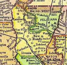
Torras is the name of a former town in the extreme northeastern corner of Pointe Coupee Parish, Louisiana, United States. The town was located along either side of the Texas & Pacific Railroad at its juncture with Lower Old River. The Mississippi River is located just to the east and the juncture of the Red and Atchafalaya Rivers just to the west.
Billeaud is an unincorporated community in Lafayette Parish, Louisiana, United States.
Pont Des Mouton is an unincorporated community in Lafayette Parish, Louisiana, United States.
Red River Landing was the name of a community located in northern Pointe Coupee Parish, Louisiana, United States. The community was located near the Red River and the Mississippi River.
Parlange is the name of a community located in southern Pointe Coupee Parish, Louisiana, United States. The community was along Louisiana Highway 1, on the banks of False River.
Latanes is an unincorporated community in Westmoreland County, in the U. S. state of Virginia.
Garfield Avenue is a major north-south street in Los Angeles County, California, US.

Balch Camp is an unincorporated community in Fresno County, California. It is located near the confluence of the North Fork of the Kings River and Dinkey Creek 38 miles (61 km) east-northeast of Fresno, at an elevation of 1273 feet.
Mapleton, New York is a hamlet in the town of Pendleton in Niagara County, New York, United States.
Stockton is a neighborhood in San Diego, California bordered by Golden Hill to the north, Mountain View and Mt. Hope to the east, Grant Hill to the west, and Logan Heights to the south. I-15 forms the eastern boundary.

Farmers is an unincorporated community in the southwest corner of Franklin Township, Owen County, in the U.S. state of Indiana. It lies just south of US Highway 231 at the intersection of 650 West, which is a community about twelve miles south of the city of Spencer, the county seat of Owen County. Its elevation is 591 feet, and it is located at 39°10′31″N86°53′30″W. This community is also known as Farmers Station.


