
Iberville Parish is a parish located south of Baton Rouge in the U.S. state of Louisiana, formed in 1807. The parish seat is Plaquemine. The population was 30,241 at the 2020 census.
Belle Rose is a census-designated place (CDP) in Assumption Parish, Louisiana, United States. The population was 1,902 at the 2010 census. It is part of the Pierre Part micropolitan statistical area.
Supreme is a census-designated place (CDP) in Assumption Parish, Louisiana, United States. The population was 1,052 at the 2010 census. In 2020, its population was 839.

Plaquemine is a city in and the parish seat of Iberville Parish, Louisiana, United States. It is part of the Baton Rouge metropolitan statistical area. At the 2010 United States census, the population was 7,119; the 2020 census determined its population was 6,269.
Woodmere is an unincorporated community and census-designated place (CDP) in Jefferson Parish, Louisiana, United States. The population was 12,080 at the 2010 census, and 11,238 at the 2020 census. It is part of the New Orleans–Metairie–Kenner metropolitan statistical area.

Killona is a census-designated place (CDP) in St. Charles Parish, Louisiana, United States. The population was 724 in 2020. On December 14, 2022, the town was hit by a destructive and deadly EF2 tornado that damaged or destroyed numerous structures, killed one person, and injured eight others.
Montz is a census-designated place (CDP) in St. Charles Parish, Louisiana, United States. It first appeared in the 2000 census with a population of 1,120. The 2020 census indicates a population of 2,106.

Taft is a census-designated place (CDP) in St. Charles Parish, Louisiana, United States, located on the west bank of the Mississippi River.
Garyville is a census-designated place (CDP) in St. John the Baptist Parish, Louisiana, United States. The population was 2,775 at the 2000 census and 2,123 in 2020. It is part of the New Orleans–Metairie–Kenner Metropolitan Statistical Area.
Wallace is a census-designated place (CDP) in St. John the Baptist Parish, Louisiana, United States. The population was 570 at the 2000 census. It is part of the New Orleans–Metairie–Kenner Metropolitan Statistical Area. The rural community is on the west bank of the Mississippi River and easily accessible to Interstate 10 via the Gramercy Bridge.
Venice is an unincorporated community and census-designated place in Plaquemines Parish, Louisiana, United States. As of the 2020 census, its population was 162. It is 77 miles (124 km) south of New Orleans on the west bank of the Mississippi River at 29°16′37″N89°21′17″W. It is the last community down the Mississippi accessible by automobile, and it is the southern terminus of the Great River Road. This has earned the town the nickname "The end of the world." The ZIP code for Venice is 70091.
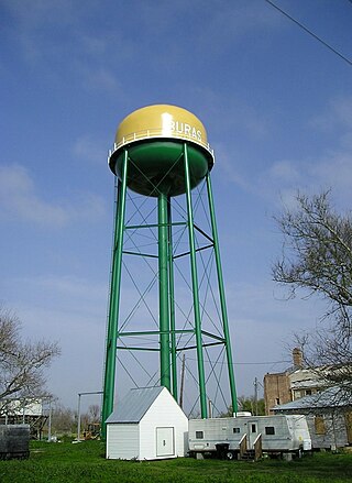
Buras is a census-designated place (CDP) in Plaquemines Parish, Louisiana, United States. Its population was 945 at the 2010 census, and 1,109 in 2020. Prior to the 2010 census, Buras was considered to be part of the Buras-Triumph CDP.
Bayou Goula is an unincorporated community and census-designated place (CDP) in Iberville Parish, Louisiana, United States. Its population was 514 in 2020.
Grand Point is an unincorporated community and census-designated place in St. James Parish, Louisiana, United States. Its population was 2,473 as of the 2010 census.
Hester is an unincorporated community and census-designated place in St. James Parish, Louisiana, United States. It was first listed as a CDP in the 2010 census with a population of 498. The community is located along Louisiana Highway 44 on the east bank of the Mississippi River.
Welcome is an unincorporated community and census-designated place in St. James Parish, Louisiana, United States. The community is located along Louisiana Highway 18 on the west bank of the Mississippi River.
Moonshine is an unincorporated community and census-designated place in St. James Parish, Louisiana, United States. It was first listed in the 2010 census with a population was 194. The community is located on the west bank of the Mississippi River.
Romeville is an unincorporated community and census-designated place in St. James Parish, Louisiana, United States. Its population was 130 as of the 2010 census. The community is located along Louisiana Highway 44 on the east bank of the Mississippi River.
Union is an unincorporated community and census-designated place in St. James Parish, Louisiana, United States. The community is located along Louisiana Highway 44 on the east bank of the Mississippi River.

Dorseyville is a census-designated place (CDP) in Iberville Parish, Louisiana, United States, corresponding to the unincorporated community of Dorcyville or Dorseyville. Dorseyville was first listed as a CDP prior to the 2020 census with a population of 159.


