Allens Spring, Illinois

Last updated
Allens Spring, Illinois
USA Illinois location map.svg
Red pog.svg
Allens Spring, Illinois
Usa edcp location map.svg
Red pog.svg
Allens Spring, Illinois
Coordinates: 37°22′08″N88°39′25″W / 37.36889°N 88.65694°W / 37.36889; -88.65694 Coordinates: 37°22′08″N88°39′25″W / 37.36889°N 88.65694°W / 37.36889; -88.65694
Country United States
State Illinois
County Pope
Elevation
482 ft (147 m)
Time zone UTC-6 (Central (CST))
  Summer (DST) UTC-5 (CDT)
Area code(s) 618
GNIS feature ID422399 [1]

Allens Spring is an unincorporated community in Pope County, in the U.S. state of Illinois. [1]

Pope County, Illinois County in the United States

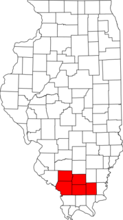
Pope County is a county located in the U.S. state of Illinois. According to the 2010 census, it had a population of 4,470, making it the second-least populous county in Illinois. Its county seat is Golconda. The county was organized in 1816 from portions of Gallatin and Johnson counties and named after Nathaniel Pope, a politician and jurist from the Illinois Territory and State of Illinois.

U.S. state constituent political entity of the United States

In the United States, a state is a constituent political entity, of which there are currently 50. Bound together in a political union, each state holds governmental jurisdiction over a separate and defined geographic territory and shares its sovereignty with the federal government. Due to this shared sovereignty, Americans are citizens both of the federal republic and of the state in which they reside. State citizenship and residency are flexible, and no government approval is required to move between states, except for persons restricted by certain types of court orders. Four states use the term commonwealth rather than state in their full official names.

Illinois State of the United States of America

Illinois is a state in the Midwestern region of the United States. It has the 5th largest Gross Domestic Product by state, is the 6th-most populous U.S. state and 25th-largest state in terms of land area. Illinois is often noted as a microcosm of the entire United States. With Chicago in the northeast, small industrial cities and great agricultural productivity in northern and central Illinois, and natural resources such as coal, timber, and petroleum in the south, Illinois has a diverse economic base, and is a major transportation hub. Chicagoland, Chicago's metropolitan area, contains over 65% of the state's population. The Port of Chicago connects the state to other global ports around the world from the Great Lakes, via the Saint Lawrence Seaway, to the Atlantic Ocean; as well as the Great Lakes to the Mississippi River, via the Illinois Waterway on the Illinois River. The Mississippi River, the Ohio River, and the Wabash River form parts of the boundaries of Illinois. For decades, Chicago's O'Hare International Airport has been ranked as one of the world's busiest airports. Illinois has long had a reputation as a bellwether both in social and cultural terms and, through the 1980s, in politics.

History

A post office was established at Allen Spring in 1857, and remained in operation until 1928. [2] George M. Allen, an early postmaster, gave the community his name. [3]

Related Research Articles

Williamson County, Illinois County in the United States

Williamson County is a county located in the southern part of the U.S. state of Illinois. According to the 2010 census, it had a population of 66,357. Its county seat is Marion.

Saline County, Illinois County in the United States

Saline County is a county located in the U.S. state of Illinois. According to the 2010 census, it had a population of 24,913. Its county seat is Harrisburg. It is located in the southern portion of Illinois known locally as "Little Egypt".

Massac County, Illinois County in the United States

Massac County is a county in the U.S. state of Illinois. According to the 2010 census, it had a population of 15,429. Established in 1843 and named for a French fort founded in the 18th century, its county seat is Metropolis.

Kane County, Illinois County in the United States

Kane County is a county in the U.S. state of Illinois. According to the 2010 census, it has a population of 515,269, making it the fifth-most populous county in Illinois. Its county seat is Geneva, and its largest city is Aurora.

Johnson County, Illinois County in the United States

Johnson County is a county located in the U.S. state of Illinois. According to the 2010 census, it has a population of 12,582. Its county seat is Vienna. It is located in the southern portion of Illinois known locally as "Little Egypt".

Jersey County, Illinois County in the United States

Jersey County is a county located in the U.S. state of Illinois. According to the 2010 census, it has a population of 22,985. The county seat is Jerseyville.

Hardin County, Illinois County in the United States

Hardin County is a county located in the U.S. state of Illinois. According to the 2010 census, it has a population of 4,320, making it the least populous county in Illinois. Its county seat is Elizabethtown. Hardin County is located in the part of the state known as Little Egypt. Hardin County was named for Hardin County, Kentucky, which was named in honor of Colonel John Hardin, an officer in the American Revolutionary War and the Northwest Indian War.

Gallatin County, Illinois County in the United States

Gallatin County is a county located in the U.S. state of Illinois. According to the 2010 census, it has a population of 5,589, making it the fifth-least populous county in Illinois. Its county seat is Shawneetown. It is located in the southern portion of Illinois known locally as "Little Egypt".

Nora or Norah may refer to:

Daniel Pope Cook was a politician, lawyer and newspaper publisher from the U.S. state of Illinois. An anti-slavery advocate, he was the state's first Attorney General, and then congressman. Cook County, Illinois is named after him.

Dixon Springs State Park

Dixon Springs State Park is an Illinois state park in Pope County, Illinois, United States, and is one of several state parks in the Illinois Shawnee Hills. The park is on a giant block of rock which was dropped 200 feet (61 m) along a fault that extends northwesterly across Pope County. The 801-acre (324 ha) park is about 10 miles (16 km) west of Golconda on Illinois Route 146 near its junction with Illinois Route 145. The first land acquisition was in 1946.

Lyons Township, Cook County, Illinois Township in Illinois, United States

Lyons Township is one of 29 townships in Cook County, Illinois, USA. As of the 2010 census, its population was 111,688. Lyons Township was established in 1850. The nearby unincorporated area of Lyons is often incorrectly referred to as "Lyons Township"

Metro Lakeland

Metro Lakeland is a name that was coined in the 1960s for an area of southern Illinois that is centered on the intersections of Interstate 57, Interstate 24, and Illinois Route 13 — a four-lane east-west highway connecting the communities of Murphysboro, Carbondale, Carterville, Herrin, Marion, and Harrisburg. Metro Lakeland was defined as Jackson, Williamson, Franklin, Saline, and Perry counties, with a combined population of approximately 210,000. Carbondale, Herrin, and Marion are the key urban areas, with a combined city-proper population of over 65,000 Carbondale, the site of Southern Illinois University, is the region's largest city. Metro Lakeland is about 88 miles (142 km) southeast of St. Louis, Missouri, or 120 miles (190 km) by Interstate highway.

Allens Corners, Illinois Unincorporated community in Illinois, United States

Allen's Corners is an unincorporated community in Kane County, Illinois, United States. Allen's Corner is a landmark of the Allen family, the first settlers of Kane County in 1836. First known as blacksmiths and farmers, the towing business was started in 1937. The community is located at the intersection of U.S. Route 20 and Allen and Brier Hill roads.

Dixon Springs, Illinois Unincorporated community in Illinois, United States

Dixon Springs is an unincorporated community in Pope County, Illinois, United States. Dixon Springs is 10 miles (16 km) west of Golconda.

Brownfield, Illinois Unincorporated community in Illinois, United States

Brownfield is an unincorporated community in Pope County, Illinois, United States. Brownfield is 7 miles (11 km) west-southwest of Golconda. Brownfield once had a post office, which closed on July 27, 1991.

Darmstadt, Illinois Census-designated place in Illinois, United States

Darmstadt is a census-designated place in St. Clair County, Illinois, United States. Its population was 68 as of the 2010 census.

Bailey Springs, Alabama Unincorporated community in Alabama, United States

Bailey Springs, also known as Chalybeate Springs, is an unincorporated community in Lauderdale County, Alabama, United States.

Eastburn, Illinois Unincorporated community in Illinois, United States

Eastburn is an unincorporated community in Iroquois County, in the U.S. state of Illinois.

References

  1. 1 2 U.S. Geological Survey Geographic Names Information System: Allens Spring, Illinois
  2. "Pope County". Jim Forte Postal History. Retrieved 7 November 2015.
  3. Callary, Edward (29 September 2008). Place Names of Illinois. University of Illinois Press. p. 5. ISBN   978-0-252-09070-7.