Homberg, Illinois

Last updated
Homberg, Illinois
Unincorporated community
USA Illinois location map.svg
Red pog.svg
Homberg, Illinois
Usa edcp location map.svg
Red pog.svg
Homberg, Illinois
Coordinates: 37°19′31″N88°33′07″W / 37.32528°N 88.55194°W / 37.32528; -88.55194 Coordinates: 37°19′31″N88°33′07″W / 37.32528°N 88.55194°W / 37.32528; -88.55194
Country United States
State Illinois
County Pope
Elevation 367 ft (112 m)
Time zone Central (CST) (UTC-6)
  Summer (DST) CDT (UTC-5)
Area code(s) 618
GNIS feature ID 425007 [1]

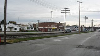
Homberg is an unincorporated community in Pope County, Illinois, United States, near the Ohio River and about five miles (8 km) southwest of the county seat of Golconda. It is on a flat riverbed, a former channel of the Ohio River when the river turned west and flowed a bit south of the present Illinois Route 146, crossing the current Mississippi River south of Cape Girardeau, Missouri, eventually merging with the Mississippi of that time, near Memphis, Tennessee. Earthquakes of 10,000 years ago may have helped change the channels of the rivers.

Pope County, Illinois County in the United States

Pope County is a county located in the U.S. state of Illinois. According to the 2010 census, it had a population of 4,470, making it the second-least populous county in Illinois. Its county seat is Golconda. The county was organized in 1816 from portions of Gallatin and Johnson counties and named after Nathaniel Pope, a politician and jurist from the Illinois Territory and State of Illinois.

Illinois State of the United States of America

Illinois is a state in the Midwestern and Great Lakes region of the United States. It has the fifth largest gross domestic product (GDP), the sixth largest population, and the 25th largest land area of all U.S. states. Illinois is often noted as a microcosm of the entire United States. With Chicago in northeastern Illinois, small industrial cities and immense agricultural productivity in the north and center of the state, and natural resources such as coal, timber, and petroleum in the south, Illinois has a diverse economic base, and is a major transportation hub. Chicagoland, Chicago's metropolitan area, encompasses over 65% of the state's population. The Port of Chicago connects the state to international ports via two main routes: from the Great Lakes, via the Saint Lawrence Seaway, to the Atlantic Ocean and from the Great Lakes to the Mississippi River, via the Illinois Waterway to the Illinois River. The Mississippi River, the Ohio River, and the Wabash River form parts of the boundaries of Illinois. For decades, Chicago's O'Hare International Airport has been ranked as one of the world's busiest airports. Illinois has long had a reputation as a bellwether both in social and cultural terms and, through the 1980s, in politics.

United States Federal republic in North America

The United States of America (USA), commonly known as the United States or America, is a country composed of 50 states, a federal district, five major self-governing territories, and various possessions. At 3.8 million square miles, the United States is the world's third or fourth largest country by total area and is slightly smaller than the entire continent of Europe's 3.9 million square miles. With a population of over 327 million people, the U.S. is the third most populous country. The capital is Washington, D.C., and the largest city by population is New York City. Forty-eight states and the capital's federal district are contiguous in North America between Canada and Mexico. The State of Alaska is in the northwest corner of North America, bordered by Canada to the east and across the Bering Strait from Russia to the west. The State of Hawaii is an archipelago in the mid-Pacific Ocean. The U.S. territories are scattered about the Pacific Ocean and the Caribbean Sea, stretching across nine official time zones. The extremely diverse geography, climate, and wildlife of the United States make it one of the world's 17 megadiverse countries.

A rail line, used to transport feldspar mined near Rosiclare, ran through Homberg, which was abandoned as the mining died. Constructing the rail line brought its special problems. The rail line was officially removed in 1982{fact}. A small foodstore which doubled as a post office, continued until the 1970s. The bluff along the north side of the old river bed is 240 feet high.

Feldspar A group of rock-forming tectosilicate minerals

Feldspars (KAlSi3O8 – NaAlSi3O8 – CaAl2Si2O8) are a group of rock-forming tectosilicate minerals that make up about 41% of the Earth's continental crust by weight.

Reevesville and Brownfield were two nearby rail stops. A story handed down by a Homberg family recounts that:
In 1902, people were dressed in their Sunday best clothes to welcome the first train on the track. The ladies were, of course, conditioned to think only of horse transportation. The train stopped so they could have a look at it. Then the train engineer announced "Ladies, please put your parasols down, because it makes the train afraid to pass." Legend says two or three ladies dutifully folded up their parasols, before they likely heard chuckles from the crowd.

Horse Domesticated four-footed mammal from the equine family

The horse is one of two extant subspecies of Equus ferus. It is an odd-toed ungulate mammal belonging to the taxonomic family Equidae. The horse has evolved over the past 45 to 55 million years from a small multi-toed creature, Eohippus, into the large, single-toed animal of today. Humans began domesticating horses around 4000 BC, and their domestication is believed to have been widespread by 3000 BC. Horses in the subspecies caballus are domesticated, although some domesticated populations live in the wild as feral horses. These feral populations are not true wild horses, as this term is used to describe horses that have never been domesticated, such as the endangered Przewalski's horse, a separate subspecies, and the only remaining true wild horse. There is an extensive, specialized vocabulary used to describe equine-related concepts, covering everything from anatomy to life stages, size, colors, markings, breeds, locomotion, and behavior.

Related Research Articles

Mississippi River largest river system in North America

The Mississippi River is the second-longest river and chief river of the second-largest drainage system on the North American continent, second only to the Hudson Bay drainage system. Its source is Lake Itasca in northern Minnesota and it flows generally south for 2,320 miles (3,730 km) to the Mississippi River Delta in the Gulf of Mexico. With its many tributaries, the Mississippi's watershed drains all or parts of 32 U.S. states and two Canadian provinces between the Rocky and Appalachian mountains. The main stem is entirely within the United States; the total drainage basin is 1,151,000 sq mi (2,980,000 km2), of which only about one percent is in Canada. The Mississippi ranks as the fourth-longest and fifteenth-largest river by discharge in the world. The river either borders or passes through the states of Minnesota, Wisconsin, Iowa, Illinois, Missouri, Kentucky, Tennessee, Arkansas, Mississippi, and Louisiana.

Ohio River river in the midwestern United States

The Ohio River is a 981-mile (1,579 km) long river in the midwestern United States that flows southwesterly from western Pennsylvania south of Lake Erie to its mouth on the Mississippi River at the southern tip of Illinois. It is the second largest river by discharge volume in the United States and the largest tributary by volume of the north-south flowing Mississippi River that divides the eastern from western United States. The river flows through or along the border of six states, and its drainage basin includes parts of 15 states. Through its largest tributary, the Tennessee River, the basin includes several states of the southeastern U.S. It is the source of drinking water for three million people.

Quad Cities Metropolitan area in the United States

The Quad Cities is a region of five cities in the U.S. states of Iowa and Illinois: Davenport and Bettendorf in southeastern Iowa, and Rock Island, Moline, and East Moline in northwestern Illinois. These cities are the center of the Quad Cities metropolitan area, which as of 2013 had a population estimate of 383,781 and a CSA population of 474,937, making it the 90th largest CSA in the nation.

Monroe County, Illinois County in the United States

Monroe County is a county located in the U.S. state of Illinois. According to the 2010 census, it had a population of 32,957. Its county seat and largest city is Waterloo.

Calhoun County, Illinois County in the United States

Calhoun County is a county in the U.S. state of Illinois. As of the 2010 census, the population was 5,089, making it Illinois’ third-least populous county. Its county seat and biggest community is Hardin, with a population of slightly less than 1,000. Its smallest community is Hamburg, with a population of 123. Calhoun County is at the tip of the peninsula formed by the courses of the Mississippi and Illinois rivers above their confluence and is almost completely surrounded by water. Calhoun County is sparsely populated; it has just five municipalities, all of them villages.

Baltimore and Ohio Railroad former rail system in the United States of America

The Baltimore and Ohio Railroad was the first common carrier railroad and the oldest railroad in the United States, with its first section opening in 1830. It came into being mostly because the city of Baltimore wanted to compete with the newly constructed Erie Canal and another canal being proposed by Pennsylvania, which would have connected Philadelphia and Pittsburgh. At first this railroad was located entirely in the state of Maryland, with an original line built from the port of Baltimore west to Sandy Hook.

Wabash River tributary of the Ohio River in the United States of America

The Wabash River is a 503-mile-long (810 km) river in Ohio and Indiana, United States, that flows from the headwaters near the middle of Ohio's western border northwest then southwest across northern Indiana turning south along the Illinois border where the southern portion forms the Indiana-Illinois border before flowing into the Ohio River. It is the largest northern tributary of the Ohio River. From the dam near Huntington, Indiana, to its terminus at the Ohio River, the Wabash flows freely for 411 miles (661 km). Its watershed drains most of Indiana. The Tippecanoe River, White River, Embarras River and Little Wabash River are major tributaries. The river's name comes from an Illini Indian word meaning "water over white stones".

Southern Illinois Region of Illinois in the United States

Southern Illinois is the southern third of the state of Illinois. The southern part of Illinois has a unique cultural and regional history. Part of downstate Illinois, the Southern Illinois region is bordered by the two most voluminous rivers in the United States: the Mississippi River and its connecting Missouri River to the west, and the Ohio River to the east and south with the Wabash as tributary.

Swing bridge movable bridge that has a vertical locating pin and support ring about which the turning span can pivot horizontally

A swing bridge is a movable bridge that has as its primary structural support a vertical locating pin and support ring, usually at or near to its center of gravity, about which the turning span can then pivot horizontally as shown in the animated illustration to the right. Small swing bridges as found over canals may be pivoted only at one end, opening as would a gate, but require substantial underground structure to support the pivot.

Illinois Central Railroad transport company

The Illinois Central Railroad, sometimes called the Main Line of Mid-America, was a railroad in the central United States, with its primary routes connecting Chicago, Illinois, with New Orleans, Louisiana, and Mobile, Alabama. A line also connected Chicago with Sioux City, Iowa (1870). There was a significant branch to Omaha, Nebraska (1899), west of Fort Dodge, Iowa, and another branch reaching Sioux Falls, South Dakota (1877), starting from Cherokee, Iowa. The Sioux Falls branch has been abandoned in its entirety.

Gulf, Mobile and Ohio Railroad former American railroad

The Gulf, Mobile and Ohio was a Class I railroad in the central United States whose primary routes extended from Mobile, Alabama, and New Orleans, Louisiana, to St. Louis and Kansas City, Missouri, as well as Chicago, Illinois.

Honey War

The Honey War was a bloodless territorial dispute in 1839 between Iowa, then Iowa Territory, and Missouri over their border.

La Crosse Rail Bridge

La Crosse Rail Bridge is a swing bridge that spans the Mississippi River between La Crescent, Minnesota and La Crosse, Wisconsin.

Kentucky Dam

Kentucky Dam is a hydroelectric dam on the Tennessee River on the county line between Livingston and Marshall counties in the U.S. state of Kentucky. The dam is the lowermost of nine dams on the river owned and operated by the Tennessee Valley Authority, which built the dam in the late 1930s and early 1940s to improve navigation on the lower part of the river and reduce flooding on the lower Ohio and Mississippi rivers. It was a major project initiated during the New Deal of President Franklin D. Roosevelt's administration, to invest in infrastructure to benefit the country. The dam impounds the Kentucky Lake of 160,000 acres (65,000 ha), which is the largest of TVA's reservoirs and the largest artificial lake by area in the Eastern United States. It was listed on the National Register of Historic Places in 2017.

Cairo Rail Bridge

Cairo Rail Bridge is the name of two bridges crossing the Ohio River near Cairo, Illinois. The original was an 1889 George S. Morison through truss and deck truss bridge replaced by the current bridge in 1952. The second and current bridge is a through truss bridge that reused many of the original bridge piers. As of 2018, trains like the City of New Orleans travel over the Ohio River supported by the same piers whose construction began in 1887.

Ohio and Mississippi Railway

The Ohio and Mississippi Railway, abbreviated O&M, was a railroad operating between Cincinnati, Ohio, and East St. Louis, Illinois, from 1857 to 1893.

John C. Sullivan was a surveyor who established the Indian Boundary Line and the Sullivan Line which were to form the boundary between Native Americans and white settlers in Indian Territory from Iowa to Texas.

Geography of Indiana

The geography of Indiana comprises the physical features of the land and relative location of U.S. State of Indiana. Indiana is in the north-central United States and borders on Lake Michigan. Surrounding states are Michigan to the north and northeast, Illinois to the west, Kentucky to the south, and Ohio to the east. The entire southern boundary is the Ohio River.

Transportation in Chicago

Chicago, Illinois is the third-largest city in the United States and a major transportation hub for the Midwest. The city is served by two major airports, and is the main freight rail hub of North America.

Wabash Railroad transport company

The Wabash Railroad was a Class I railroad that operated in the mid-central United States. It served a large area, including track in the states of Ohio, Indiana, Illinois, Iowa, Michigan, and Missouri and the province of Ontario. Its primary connections included Chicago, Illinois; Kansas City, Missouri; Detroit, Michigan; Buffalo, New York; St. Louis, Missouri; and Toledo, Ohio.

References