Eddyville, Illinois

Last updated

Eddyville
Eddyville, IL.jpg
Eddyville post office on Main St.
Pope County Illinois Incorporated and Unincorporated areas Eddyville Highlighted.svg
Location of Eddyville in Pope County, Illinois.
Illinois in United States (US48).svg
Location of Illinois in the United States
Coordinates: 37°30′1″N88°35′13″W / 37.50028°N 88.58694°W / 37.50028; -88.58694
CountryUnited States
StateIllinois
County Pope
Area
[1]
  Total0.28 sq mi (0.73 km2)
  Land0.28 sq mi (0.73 km2)
  Water0.00 sq mi (0.00 km2)
Elevation
[2]
682 ft (208 m)
Population
 (2020)
  Total99
  Density352.31/sq mi (136.01/km2)
Time zone UTC-6 (CST)
  Summer (DST) UTC-5 (CDT)
ZIP Code(s)
62928
Area code 618
FIPS code 17-22398
GNIS ID2398782 [2]
Wikimedia CommonsEddyville, Illinois

Eddyville is a village in Pope County, Illinois, United States. The population was 153 at the 2000 census. Two designated wilderness areas, the Burden Falls Wilderness and the Lusk Creek Wilderness, are nearby.

Contents

History

Eddyville was laid out in 1866, and named for Edward Fulghum, who owned the land where the village is located. [3] A post office has been in operation at Eddyville since 1869. [4] Eddyville was incorporated as a village in 1883. [5]

Geography

Eddyville is located at 37°30′1″N88°35′13″W / 37.50028°N 88.58694°W / 37.50028; -88.58694 (37.500412, -88.587024). [6]

According to the 2010 census, Eddyville has a total area of 0.291 square miles (0.75 km2), of which 0.29 square miles (0.75 km2) (or 99.66%) is land and 0.001 square miles (0.00 km2) (or 0.34%) is water. [7]

Demographics

Historical population
CensusPop.Note
1880 114
1890 21286.0%
1900 162−23.6%
1910 145−10.5%
1920 17319.3%
1930 115−33.5%
1940 14425.2%
1950 106−26.4%
1960 12517.9%
1970 1271.6%
1980 14312.6%
1990 1515.6%
2000 1531.3%
2010 101−34.0%
2020 99−2.0%
U.S. Decennial Census [8]

As of the census [9] of 2000, there were 153 people, 65 households, and 41 families residing in the village. The population density was 533.1 inhabitants per square mile (205.8/km2). There were 78 housing units at an average density of 271.8 per square mile (104.9/km2). The racial makeup of the village was 93.46% White, 1.31% Native American, 1.31% Asian, 0.65% from other races, and 3.27% from two or more races. Hispanic or Latino of any race were 0.65% of the population.

There were 65 households, out of which 38.5% had children under the age of 18 living with them, 46.2% were married couples living together, 16.9% had a female householder with no husband present, and 35.4% were non-families. 35.4% of all households were made up of individuals, and 16.9% had someone living alone who was 65 years of age or older. The average household size was 2.35 and the average family size was 3.05.

In the village, the population was spread out, with 30.1% under the age of 18, 7.2% from 18 to 24, 29.4% from 25 to 44, 18.3% from 45 to 64, and 15.0% who were 65 years of age or older. The median age was 34 years. For every 100 females, there were 109.6 males. For every 100 females age 18 and over, there were 84.5 males.

The median income for a household in the village was $22,083, and the median income for a family was $40,000. Males had a median income of $22,500 versus $20,000 for females. The per capita income for the village was $13,084. About 13.9% of families and 16.8% of the population were below the poverty line, including 32.3% of those under the age of eighteen and 5.9% of those 65 or over.

Related Research Articles

<span class="mw-page-title-main">Lyon County, Kentucky</span> County in Kentucky, United States

Lyon County is a county located in the U.S. state of Kentucky. As of the 2020 census, the population was 8,680. Its county seat is Eddyville. The county was formed from Caldwell County, Kentucky in 1854 and named for former Congressman Chittenden Lyon.

<span class="mw-page-title-main">Pope County, Illinois</span> County in Illinois, United States

Pope County is the southeasternmost county in the U.S. state of Illinois. According to the 2020 census, it had a population of 3,763, making it the second-least populous county in Illinois. Its county seat is Golconda. The county was organized in 1816 from portions of Gallatin and Johnson counties and named after Nathaniel Pope, a politician and jurist from the Illinois Territory and State of Illinois.

<span class="mw-page-title-main">Deer Park, Illinois</span> Village in Illinois, United States

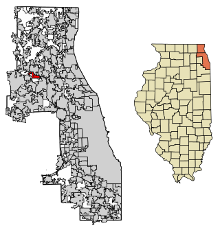
Deer Park is a village in Lake and Cook Counties, Illinois. Per the 2020 census, the population was 3,681. The village is one of the few left in the Chicago area that enjoy a green belt which is bordered by two large natural areas providing outdoor recreation and open space. The village is home to popular shopping and dining destinations: Deer Park Town Center and the Town Center Promenade. The town is also home to the Vehe Farm, an Illinois Centennial Farm.

<span class="mw-page-title-main">Hanaford, Illinois</span> Village in Illinois, United States

Hanaford is a village in Franklin County, Illinois, United States. The population was 320 at the 2020 census. Hanaford is also known as Logan.

<span class="mw-page-title-main">Thompsonville, Illinois</span> Village in Illinois, United States

Thompsonville is a village in Cave Township, Franklin County, Illinois, United States. The population was 486 at the 2020 census.

<span class="mw-page-title-main">Equality, Illinois</span> Village in Illinois, United States

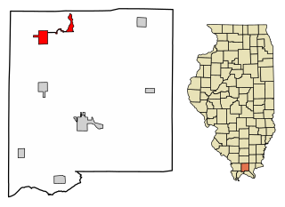
Equality is a village in Gallatin County, Illinois, United States. The population was 539 at the 2020 census. Near the village are two points of interest, the Crenshaw House and the Garden of the Gods Wilderness. Equality was the county seat of Gallatin County from 1826–1851.

<span class="mw-page-title-main">Elizabethtown, Illinois</span> Village in Illinois, United States

Elizabethtown is a village in and the county seat of Hardin County, Illinois, United States, along the Ohio River. The population was 299 at the 2010 census, down from 348 at the 2000 census. It is the least-populous county seat in the state.

<span class="mw-page-title-main">Buncombe, Illinois</span> Village in Illinois, United States

Buncombe is a village in Johnson County, Illinois, United States. The population was 203 at the 2010 census and as of 2018, the population had declined to an estimated 173.

<span class="mw-page-title-main">Goreville, Illinois</span> Village in Illinois, United States

Goreville is a village in Johnson County, Illinois, United States. The population was 1,049 as of the 2010 census, up from 938 at the 2000 census.

<span class="mw-page-title-main">Simpson, Illinois</span> Village in Illinois, United States

Simpson is a village in Johnson County, Illinois, United States. The population was 60 at the 2010 census.

<span class="mw-page-title-main">Stonefort, Illinois</span> Village in Illinois, United States

Stonefort is a village in Saline and Williamson Counties, Illinois, United States. The population was 297 at the 2010 census.

<span class="mw-page-title-main">Sauget, Illinois</span> Village in Illinois, United States

Sauget is a village in St. Clair County, Illinois, United States. It is part of Greater St. Louis. The population was 141 at the 2020 census, down from 159 in 2010.

<span class="mw-page-title-main">Alto Pass, Illinois</span> Village in Illinois, United States

Alto Pass is a village in Union County, Illinois, United States. The population was 342 at the 2020 census, a decrease from 391 in 2010. The Bald Knob Cross and Bald Knob Wilderness are nearby. Alto Pass lies roughly 5.1 miles to the northwest of downtown Cobden, Illinois. Illinois Route 127 runs just west of the village's downtown area.

<span class="mw-page-title-main">Pittsburg, Illinois</span> Village in Illinois, United States

Pittsburg is a village in Williamson County, Illinois. The population was 572 at the 2010 census.

<span class="mw-page-title-main">Chillicothe, Iowa</span> City in Iowa, United States

Chillicothe is a city in Wapello County, Iowa, United States. The population was 76 at the 2020 census.

<span class="mw-page-title-main">Fredonia, Kentucky</span> City in Kentucky, United States

Fredonia is a home rule-class city in Caldwell County, Kentucky, in the United States. The population was 401 at the 2010 census.

<span class="mw-page-title-main">Franklin, Maine</span> Town in the state of Maine, United States

Franklin is a town in Hancock County, Maine, United States. The population was 1,567 at the 2020 census. The town's namesake is Benjamin Franklin.

<span class="mw-page-title-main">Teaticket, Massachusetts</span> Census-designated place in Massachusetts, United States

Teaticket is a census-designated place (CDP) in the town of Falmouth, Massachusetts. The population was 1,692 at the 2010 census.

<span class="mw-page-title-main">Palmyra, Wisconsin</span> Village in Wisconsin, United States

Palmyra is a village in Jefferson County, Wisconsin, United States, along the Scuppernong River. It was named after the desert oasis city of Palmyra, Syria, due to its dry, sandy soil. The population was 1,719 at the 2020 census. The village is adjacent to the Town of Palmyra.

<span class="mw-page-title-main">Tower Lakes, Illinois</span> Village in Illinois, United States

Tower Lakes is a village in Lake County, Illinois, United States. Per the 2020 census, the population was 1,226.

References

  1. "2020 U.S. Gazetteer Files". United States Census Bureau. Retrieved March 15, 2022.
  2. 1 2 U.S. Geological Survey Geographic Names Information System: Eddyville, Illinois
  3. Callary, Edward (September 29, 2008). Place Names of Illinois. University of Illinois Press. p. 104. ISBN   978-0-252-09070-7.
  4. "Pope County". Jim Forte Postal History. Retrieved November 4, 2015.
  5. "Pope County Historical Reminiscences". genealogytrails.com. Illinois Genealogy Trails. Archived from the original on September 16, 2016. Retrieved August 22, 2015.
  6. "US Gazetteer files: 2010, 2000, and 1990". United States Census Bureau. February 12, 2011. Retrieved April 23, 2011.
  7. "G001 - Geographic Identifiers - 2010 Census Summary File 1". United States Census Bureau. Archived from the original on February 13, 2020. Retrieved August 3, 2015.
  8. "Census of Population and Housing". Census.gov. Retrieved June 4, 2015.
  9. "U.S. Census website". United States Census Bureau . Retrieved January 31, 2008.