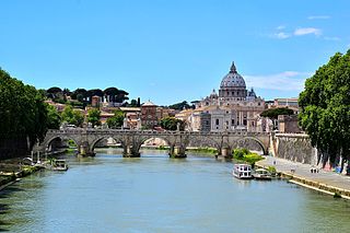
The Almone (Latin: Almo) is a small river of the Ager Romanus, a few miles south of the city of Rome. Today the river is polluted and is channelled to a sewage treatment plant and no longer reaches its natural confluence with the Tiber.
The Latin name of the Almone, Almo (also the name of its corresponding deity), is derived from the Latin word almus, meaning "fertile" or "nourishing," which may derive from its connection to Cybele, also known as Magna Mater ("Great Mother").[1][2]
In modern times the stream has been called Marrana della Caffarella. Marrana (or marana in Roman dialect) is a term that derives from the name of the ancient ager maranus, the fields that surround the Via Appia, and refers to the drainage channels that flow through the countryside near Rome.[3] "Caffarella" refers to the valley, now a park, that the river runs through. The river has also been known as Acquataccio, a name with two possible derivations. It either refers to the nearby Appian Way, a corruption of Acqua d'Appia (which became d'Accia), or the suffix -accio is to be taken in its pejorative sense, and it refers to the marshy waters of the Caffarella valley.[3]
Origin, course, and diversion
The Almone originates in the Alban Hills from springs fed by the water of Lake Albano,[nb 1] and runs through the Appian Way Regional Park, fed by the waters of the numerous springs present in the area, including the so-called Acqua Santa ("Holy Water") of the Fonte Egeria.[5][6] There, the Via Ostiensis crossed the river with a bridge known as the Travicella.[7]
In the second century, the river was used to provide water for the luxurious gardens of the villa called Triopio of Herodes Atticus,[8] erected on land brought to him by his wife, Aspasia Annia Regilla, and centuries after Rome's fall it was employed for agricultural purposes: to irrigate fields, to water cattle, and to move millstones.[6] The final stretch of the river flowed where the present-day Circonvallazione Ostiense in the Garbatella neighborhood lies. The Almone began to be used for industrial purposes in the early years of the twentieth century, when its waters were diverted to feed a paper mill on the Appian Way, but its decline accelerated in the 1920s, when its final course into the Tiber was covered over to allow the construction of the Rome-Lido railway, and also to provide water to the former thermal power plant on the Via Ostiense.[6]
Pollution of the stream has made it such that today, its waters are entirely channeled into the Magliana sewage treatment plant and no longer reach the Tiber at all.[6] It is diverted as soon as it runs under the Via Appia Antica, near Parco Scott, in back of the Piazza dei Navigatori.[6] The closest landmark to the place where it formerly emptied into the Tiber is the large Gazometro.[9][nb 2]
In antiquity
The Almone was deeply connected to the arrival of the cult of Cybele to the city of Rome, and played a central role in the city's observance of its rituals. (Andrea Mantegna, Introduction of the Cult of Cybele to Rome, 1505–1506.)
Cult of Cybele
The Almone's importance in Roman times was linked to the annual festival of the lavatio (ceremonial washing) of the sacred stone of the Phrygian goddess Cybele, which was held on March 27. The sacred black stone, which was identified with the goddess herself, was taken in procession from its temple on the Palatine Hill, through the Porta Capena, and down the Appian Way to the Almone.[9][10] There it was washed, along with the sacrificial knives pertaining to the deity's cult, at the place where the Almone flowed into the Tiber.[9][10] The priestly college of the quindecimviri attended the lavatio ceremony, and the return trip was made with great festivity.[10]
The choice of the Almone for this ceremony was inspired by events supposedly surrounding the arrival of the cult of Cybele to the city. The sacred stone was brought to Rome in 204 BC,[6] during the Second Punic War, upon the recommendation of the Sibylline Books.[9] While the ship bearing the stone was navigating the Tiber, it became beached near the area where the Almone flowed into the larger river. The ship was able to sail again only after a ritual of purification was completed.[9] The ceremony therefore alluded to, even if it did not reenact, Cybele's original arrival in the city.[11]
Based on the discovery of a small tuff basin in the Temple of Magna Mater on the Palatine, some have hypothesized that the ritual bathing of the black stone originally occurred there, and that its annual journey to the Almone was only begun during the reign of Augustus.[12] Whatever the case, there is evidence for some kind of shrine connected to Cybele on the Almone, although it seems to have been closer to the Via Appia than the place where the stream flowed into the Tiber.[12]
Hic iuvenis primam ante aciem stridente sagitta, natorum Tyrrhi fuerat qui maximus, Almo, sternitur; haesit enim sub gutture volnus et udae vocis iter tenuemque inclusit sanguine vitam.
The stream lends its name to one of the heroes in Virgil's Aeneid, the eldest son of Tyrrhus and one of the first casualties of the war between the Trojans and the Latins in Book VII.[9][2][13]
↑ According to Antonio Nibby, the water derives its source from the confluence of the Ferentine waters (Caput Aquae Ferentinum), which come from the area near Marino through the emissary of Lake Nemi.[4]
↑ "First Almon falls, old Tyrrheus' eldest care, / Pierc'd with an arrow from the distant war: / Fix'd in his throat the flying weapon stood, / And stopp'd his breath, and drank his vital blood" (John Dryden).
↑ "But if the earth is divine, so too is the sea, which you identified with Neptune, and so, therefore, are the rivers and springs. That is why Maso dedicated a shrine of Fons from his Corsican spoils, and why we see the Tiber, the Spino, the Almo, the Nodinus, and other names belonging to neighbouring streams, in the litany of the augurs" (De natura deorum III, 20).
↑ Passigli, Susanna. Ripartizioni amministrative e religiose nell'area ostiense fra XIV e XIX secolo (in Italian).
↑ L. Quilico, "La Valle delle Caffarella e il Triopio di Erode Attico", Capitolium43, 1968. See, for a recent mention of Triopio, Judith DiMaio's description of accessing the Fonte Egera nymphaeum, in Robert Kahn, ed., Rome, pp 226-227.
↑ Alvar, Jaime (2008). Romanising Oriental Gods: Myth, Salvation and Ethics in the Cults of Cybele, Isis and Mithras. Translated by Richard Gordon. Brill. pp.288–289.
The Tiber is the third-longest river in Italy and the longest river in Central Italy, rising in the Apennine Mountains in Emilia-Romagna and flowing 406 kilometres (252 mi) through Tuscany, Umbria and Lazio, where it is joined by the river Aniene, to the Tyrrhenian Sea, between Ostia and Fiumicino. It drains a basin estimated at 17,375 square kilometres (6,709 sq mi). The river has achieved lasting fame as the main watercourse of the city of Rome, founded on its eastern banks.
The Appian Way is one of the earliest and strategically most important Roman roads of the ancient republic. It connected Rome to Brindisi, in southeast Italy. Its importance is indicated by its common name, recorded by Statius:
Appia longarum... regina viarum
"the Appian Way the queen of the long roads"
Porta Capena was a gate in the Servian Wall in Rome, Italy. The gate was located in the area of Piazza di Porta Capena, where the Caelian, Palatine and Aventine hills meet. Probably its exact position was between the entrance of Via di Valle delle Camene and the beginning of Via delle Terme di Caracalla, facing the curved side of the Circus Maximus.
Egeria was a nymph attributed a legendary role in the early history of Rome as a divine consort and counselor of Numa Pompilius, the second king of Rome, to whom she imparted laws and rituals pertaining to ancient Roman religion. Her name is used as an eponym for a female advisor or counselor.
In 7 BC, Augustus divided the city of Rome into 14 administrative regions. These replaced the four regiones — or "quarters" — traditionally attributed to Servius Tullius, sixth king of Rome. They were further divided into official neighborhoods.
Fontana dei Quattro Fiumi is a fountain in the Piazza Navona in Rome, Italy. It was designed in 1651 by Gian Lorenzo Bernini for Pope Innocent X whose family palace, the Palazzo Pamphili, faced onto the piazza as did the church of Sant'Agnese in Agone of which Innocent was the sponsor.
The Porta San Sebastiano is the largest and one of the best-preserved gates passing through the Aurelian Walls in Rome (Italy).
A number of temples to Cybele in Rome have been identified. Originally an Anatolian mother goddess, the cult of Cybele was formally brought to Rome during the Second Punic War after a consultation with the Sibylline Books.
The Aqua Traiana was a 1st-century Roman aqueduct built by Emperor Trajan and inaugurated on 24 June 109 AD. It channelled water from sources around Lake Bracciano, 40 kilometers (25 mi) north-west of Rome, to Rome in ancient Roman times but had fallen into disuse by the 17th century. It fed a number of water mills on the Janiculum, including a sophisticated mill complex revealed by excavations in the 1990s under the present American Academy in Rome. Some of the Janiculum mills were famously put out of action by the Ostrogoths when they cut the aqueduct in 537 during the first siege of Rome. Belisarius restored the supply of grain by using mills floating in the Tiber. The complex of mills bears parallels with a similar complex at Barbegal in southern Gaul.
Cona is a quarter of Teramo, central Italy. It takes its name from the presence of the local church, Madonna della Cona. The Madonna della Cona is a religious symbol of abundance and fertility with a festival the first Sunday in September that is celebrated in her honor.
The Olona is an Italian river belonging to the Po Basin, 71 kilometres (44 mi) long, that runs through the Province of Varese and Metropolitan City of Milan whose course is developed entirely in Lombardy.
The Caffarella Park is a large park in Rome, Italy, protected from development. It is part of the Parco Regionale Appia Antica. The park is contained in the Caffarella Valley and is bordered on its northern side by the Via Latina and on its southern by the Appian Way. It stretches from the Aurelian Wall up to the Via dell'Almone. It contains several items of archaeological interest, as well as a working farm, and has considerable ecological value, with 78 species of birds and fauna. The Catacombs of Rome and Colli Albani are nearby.
The Fontana dell'Acqua Paola also known as Il Fontanone is a monumental fountain located on the Janiculum Hill, near the church of San Pietro in Montorio, in Rome, Italy. It was built in 1612 to mark the end of the Acqua Paola aqueduct, restored by Pope Paul V, and took its name from him. It was the first major fountain on the right bank of the River Tiber.
The Appian Way Regional Park is the largest urban park of Europe and is a protected area of around 4580 hectares, established by the Italian region of Latium. It falls primarily within the territory of Rome but parts also extend into the neighbouring towns of Ciampino and Marino.
The following outline is provided as an overview of and topical guide to Rome:
The Ufente is a river in the province of Latium, in the historic area of the Pontine Marshes. It was known as Aufentus in Latin. It flows in a channel to the Tyrrhenian Sea at Tarracina, joining a parallel channel, the Fiume Portatore, less than one kilometer from the sea.
The Villa of Maxentius is an imperial villa in Rome, built by the Roman emperor Maxentius. The complex is located between the second and third miles of the ancient Appian Way, and consists of three main buildings: the palace, the circus of Maxentius and the dynastic mausoleum, designed in an inseparable architectural unit to honor Maxentius.
The Laurentino-Acqua Acetosa nature reserve is a protected natural area located in the Province of Rome.
The Fontana dell'Acqua Acetosa is a fountain in Rome (Italy), located in the flat area with the same name, in the quarter Parioli; at this point the river Tiber forms a deep bend before heading north again. The fountain rises at a lower elevation than the street level, and is therefore accessed via a staircase. In 2003 the Fondo Ambiente Italiano, on the basis of a popular survey, identified it as the monument to which Italians are fondest of.
This page is based on this Wikipedia article Text is available under the CC BY-SA 4.0 license; additional terms may apply. Images, videos and audio are available under their respective licenses.