Khingan Nature Reserve is a Russian 'zapovednik', located in the extreme south-east of the Amur River region of the Russian Far East. The reserve covers two types of habitat: the flat Arkharinskaya lowlands with abundant wetlands, and forested spurs of the Lesser Khingan mountains. In particular, Khingan Reserve was created to protect steppe and forest-steppe landscapes, and nesting sites of the endangered Red-crowned crane and the vulnerable White-naped crane. The reserve is situated in the Arkharinsky District of Amur Oblast.

Kerzhinski Nature Reserve is a Russian 'zapovednik' located in the middle basin of the Kerzhenets River, 600 kilometres (370 mi) east of Moscow. The terrain features extensive upland and lowland swamps, and is known in particular as a site for the study of beavers, and their effects on recovery of the landscape after fires and logging. The reserve is situated 55 km northeast of the City of Nizhny Novgorod in the Bor and Semonov districts of Nizhny Novgorod Oblast. The site has been a center for scientific study of nature of the region since 1933. It is part of a UNESCO Biosphere Reserves, Ramsar wetland. The reserve was established in its current form in 1993, and covers an area of 46,940 ha (181.2 sq mi).

Belogorye Nature Reserve is a Russian 'zapovednik', one of the last intact riverine old-growth oak forests, which was once representative of the East European forest-steppe. The reserve is one of the oldest and smallest nature reserves in Russia, first formed in 1924 but reorganized several times since. It is on the southwestern slope of the Central Hills on the western edge of Russia. The reserve is situated in the Belgorodsky District of Belgorod Oblast. The reserve was created in 1935, and covers an area of 2,131 ha (8.23 sq mi).

Bolshekhekhtsirsky Nature Reserve is a Russian 'zapovednik' covering and named for the Big Khekhtsir Ridge, about 20 km south of the city of Khabarovsk, in the Russian Far East. The area is noteworthy for its position - close to a city and relatively open to public hikers on certain trails - and for being an island of mountain-forest biodiversity surrounded by lower river floodplains. The reserve is situated in the Khabarovsk Krai. The reserve was created in 1963, and covers an area of 45,439 ha (175.44 sq mi).

Bastak Nature Reserve is a Russian 'zapovednik' located in the Amur River basin in the Russian Far East. The reserve's territory covers the south-eastern spurs Bureya Range and the northern outskirts of the Sredneamurskaya lowlands. The reserve is situated in about 10 km north of the city of Birobidzhan in the Birobidzhansky District, and is the only national reserve in the Jewish Autonomous Oblast.

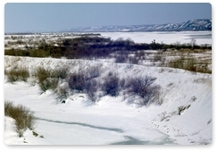
Bolon Nature Reserve is the oldest Russian 'zapovednik' in the Russian Far East. It is located on the Middle Amur River lowlands adjacent to the south-west of Lake Bolon. The reserve covers the wetlands of international importance. Large numbers of migratory waterfowl use the area for nesting and stopovers on long flights. The reserve is situated half way between the city of Khabarovsk and Komsomolsk-on-Amur, in the Amursky District of Khabarovsk Krai. The reserve was created in 1997, and covers an area of 100,000 ha (390 sq mi).
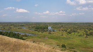
Voronina (Voroninsky) Nature Reserve is a strict ecological reserve located in the valley of the Vorona River, in the forest-steppe zone of southwest Russia. The Voroninsky Reserve protects riverine wetlands in the southeast of the Oka–Don Plain. The reserve is situated in Kirsanovsky and Inzhavinsky districts of Tambov Oblast, about 100 km southeast of the city of Tambov. It was created in 1994, and covers an area of 10,819 ha (41.77 sq mi).

Kaluzhskiye Zaseki Nature Reserve is a Russian zapovednik. Zaseki in Russian means abatises, field fortifications made of felled trees. In medieval times, the Kaluga region was part of the defensive line between the Russian forests to the north and potential invaders from the south. The reserve has been protected in some form for a thousand years, and remains old-growth forest. The reserve is situated in the Ulyanovsky District, Kaluga Oblast. It was formally established in 1992 and has an area of 18,533 hectares (71.56 sq mi).

Khanka Nature Reserve is a Russian 'zapovednik' that covers portions of the shore and waters of Lake Khanka, the largest freshwater lake in the Russian Far East. It is an important area for nesting and migrating waterfowl and other birds. The reserve is divided into five distinct sectors on the southern and eastern shores of the lake. The reserve is situated in the Spassky District, in the southwest of Primorsky Krai. It was formally established in 1990, and covers an area of 437 km2 (169 sq mi). It is part of a UNESCO Biosphere Reserve.

Privolzhskaya Lesostep Nature Reserve is a Russian zapovednik situated in the watershed midway between the Volga River and the Don River. The reserve is divided into 5 sectors, all in the western part of the Volga Uplands. Three of the sectors are steppe terrain, and two are forests. Rivers with upper reaches in the reserve flow into both the Don and the Volga. Administratively, the reserve is situated in the Kuznetsky District of Penza Oblast. The reserve was formally established in 1989 with the stated purpose of protecting representative habitat of the northern steppes, and the transition zone from steppe to forest. Some sections of the reserve, however, have been protected since 1919. In all, the reserve sectors cover an area of 8,373 ha (32.33 sq mi), and has additional buffer zones out to 1 km from the reserve borders.

Orenburg Nature Reserve is a Russian 'zapovednik' dedicated to the preservation and restoration of four separate types of steppe landscape: Transvolga, Ural Mountains, Southern Urals and Trans-Urals. The reserve does this by spreading out across four sections across 400 km of steppes in Orenburg Oblast below the southern terminus of the Ural Mountains. The city of Orenburg sits in the middle of the four sectors, approximately 1,200 km southeast of Moscow. The reserve also protects historical and archaeological sites of the Sarmation people from the seventh to third century BCE. The reserve was formally established in 1988, and covers a total area of 21,653 ha (83.60 sq mi).

The Da Hinggan-Dzhagdy Mountains conifer forests ecoregion covers the Greater Khingan Mountains of Northeast China, and across the border north into the Russian Far East where it follows the mountain ridge for another 500 km to the east. The mountain forests exhibit a floral community called "Daurian flora", a combination of the Siberian taiga to the north and the Manchurian floral types to the south. The eastern slopes are steep and drained by many rivers, the western slopes are gentler, and there are grasslands on some slopes. The ecoregion is in the Palearctic realm, with a subarctic climate. It covers 35,199,998 km2 (13,590,795 sq mi).

The Daurian forest steppe ecoregion is a band of grassland, shrub terrain, and mixed forests in northeast Mongolia and the region of Siberia, Russia that follows the course of the Onon River and Ulz River, and part of the northwestern China. The region has been described as a “sea of grass that forms the best and most intact example of an undisturbed steppe ecosystem and is also one of the last areas in the Palearctic that still supports stable herds of larger vertebrates” in a semi-mountainous area. The area also has flat wetlands that are important to migratory birds. The ecoregion is in the Palearctic realm, with a dry-winter subarctic climate that borders on a very cold semi-arid climate (BSk) in its southwestern parts. It covers 209,012 km2 (80,700 sq mi).

The Ussuri broadleaf and mixed forests ecoregion covers a mountainous areas above the lower Amur River and Ussuri River in Primorsky Krai and Khabarovsk Krai in the Russian Far East. The ecoregion is in the Palearctic realm, with a Humid Continental climate. It covers 187,357 km2 (72,339 sq mi).
The East European forest steppe ecoregion is a patchwork of broadleaf forest stands and grasslands (steppe) that stretches 2,100 km across eastern Europe from the Ural Mountains in Ural, through Povolzhye, Central Russia to the middle of Ukraine.There are isolated areas of similar character off the western end in eastern Romania, Moldova, and Bulgaria.
The Kazakh forest steppe ecoregion is a long thin strip of transition zone between the forested taiga of Siberian Russia, and the Kazakh steppe to the south. The ecoregion stretches over 2,000 km from the southern Ural mountains in the west to the foothills of Altai mountains in the east, yet averages only 200 km from south to north across its length. Because the region is farther inland than European forest steppe, and some 300 to 500 km farther north, the climate is more continental and with less precipitation the tree cover more sparse. The ecoregion is in the Temperate grasslands, savannas, and shrublands biome, and the Palearctic realm, with a Humid Continental climate. It covers 420,614 km2 (162,400 sq mi).

The Sayan intermontane steppe ecoregion is sometimes referred to as a "steppe island", being an expanse of grassland and shrubs surrounded by mountain forests in the Tyva Republic of south central Siberia, Russia. The Altai Mountains are to the west, the Sayan Mountains to the north, and the Tannu-Ola Mountains to the south. The ecoregion is in the temperate grasslands, savannas, and shrublands biome, and the Palearctic realm, with a Humid Continental climate. For much of its length, it follows the course of the upper Yenisei River. It covers 33,928 km2 (13,100 sq mi).

The Selenge–Orkhon forest steppe ecoregion stretches across north central Mongolia, and follows the Selenga River northeast into Russia. The ecoregion is itself at high elevations, but surrounded by higher mountain ranges. As a transition zone between taiga and steppe, it features conifer forests on the north slopes of mountains, and pine/aspen stands on southern slopes. It has an area of 227,660 square kilometres (87,900 sq mi).
The Suiphun–Khanka meadows and forest meadows ecoregion is a relatively small ecoregion centered on Lake Khanka, a fresh water lake in the Russian Far East, with a portion in China. The terrain is unforested, flat, and marshy. The area is an important stopover spot for migratory birds, including many vulnerable species. It has an area of 33,929 square kilometres (13,100 sq mi), and is in the Flooded grasslands and savannas biome.

The Sayan Alpine meadows and tundra ecoregion is an ecoregion that covers the high areas of the Sayan Mountains above the treeline, between the Altai Mountains in the west and Lake Baikal in the east. The area is remote and protects diverse species of alpine flora and fauna. It has an area of 846,149 square kilometres (326,700 sq mi).

