Argyle, Texas

Last updated

Argyle, Texas
Argyle Town Hall.JPG
Argyle Town Hall
Argyle, Texas
Argyle, Texas
Argyle, Texas
Argyle, Texas
Coordinates: 33°6′59″N97°11′8″W / 33.11639°N 97.18556°W / 33.11639; -97.18556
Country United States
State Texas
County Denton
Area
[1]
  Total11.61 sq mi (30.06 km2)
  Land11.56 sq mi (29.93 km2)
  Water0.05 sq mi (0.12 km2)
Elevation
[2]
719 ft (219 m)
Population
 (2020)
  Total4,403
  Estimate 
(2022)
5,503
  Density473.98/sq mi (1,227.60/km2)
Time zone UTC-6 (Central (CST))
  Summer (DST) UTC-5 (CDT)
ZIP code
76226
Area code 940
FIPS code 48-03768 [3]
GNIS feature ID2409728 [2]
Website Argyle, TX

Argyle is an affluent city in Denton County, Texas, United States, with a population of 5,503 as of 2022. [4] It is a suburb of Fort Worth.

Contents

History

The first European settlement, consisting of a few families, occurred in the Argyle area in the 1850s. The place was then known as Pilot Knob or Waintown. The settlement gradually acquired a few amenities in the late 1800s: a school in 1875, a Baptist church in 1876, and a post office in 1878. The community was formally founded and renamed Argyle in 1881, after the Texas and Pacific railroad built a track through the area. Some believe a railroad surveyor named the town after a garden in France. However, others believe the town to be named after the region of Argyll in Scotland. Also around this time was when Sam Bass, an infamous outlaw who stole $60,000 in gold coins from the Union Pacific Railroad, was rumored to have stashed the gold in a cave. Sam Bass died when he was 27, and it was rumored he never lived to retrieve the gold.

Growth was very slow during the nineteenth century, and by 1890 Argyle only had a population of 148. The town did boast several agriculture-related industries, such as grist mills, general stores, and a cotton gin. In 1885 Argyle built a two-story brick school, and population grew until it reached 238 in 1930. A bank was also established in 1906, a little red brick building with a drugstore in the front. The bank wasn't around long before it was robbed in 1912. The robbers made away with $1700 and were never caught. Electricity and telephone service became available in the mid-1930s.

The Great Depression took its toll on the Argyle area, and the population declined to only ninety in 1950. Argyle incorporated as a separate city on September 19, 1960, with M.H. Wilson as the first mayor. Gradually the town grew in population as more people from the Dallas–Fort Worth area discovered its rural charm. By the 1970s a number of retail establishments were located in Argyle, and the population reached 1,575 in 1990, and doubled from that figure to 3,282 at the 2010 census. The high rate of growth is expected to continue as part of the general development of northern areas in the Dallas–Fort Worth metroplex.

Geography

Argyle is located at 33°6′59″N97°11′8″W / 33.11639°N 97.18556°W / 33.11639; -97.18556 (33.116422, –97.185461). [5] According to the United States Census Bureau, the town has a total area of 11.4 square miles (29.6 km2), of which 11.4 square miles (29.5 km2) is land and 0.04 square miles (0.1 km2), or 0.41%, is water. [6]

Demographics

Historical population
CensusPop.Note
1970 443
1980 1,111150.8%
1990 1,57541.8%
2000 2,36550.2%
2010 3,28238.8%
2020 4,40334.2%
U.S. Decennial Census [7]
Argyle racial composition as of 2020 [4]
(NH = Non-Hispanic) [lower-alpha 1]
RaceNumberPercentage
White (NH)3,75985.37%
Black or African American (NH)350.79%
Native American or Alaska Native (NH)240.55%
Asian (NH)350.79%
Some Other Race (NH)70.16%
Mixed/Multi-Racial (NH)1914.34%
Hispanic or Latino 3527.99%
Total4,403

As of the 2022 United States census, there were 5,503 people, 1,780 households, and approximately 1,301 families residing in the city.

Education and local notes

The Argyle Independent School District serves the town of Argyle and neighboring areas. The district contains five schools: Hilltop Elementary (grades PreK–3), Argyle West Elementary (grades PreK–5), intermediate (grades 4 and 5), middle (grades 6–8), and a high school (grades 9–12). Argyle High School is in classification 4A D1 for UIL. In addition, Liberty Christian School is also located in Argyle, offering grades PK3–12.

Argyle has established a police department and a municipal court, and has a low crime rate. The town sponsored an annual bluegrass music festival, but this ended in 2012.

Notable people

Notes

  1. Note: the US Census treats Hispanic/Latino as an ethnic category. This table excludes Latinos from the racial categories and assigns them to a separate category. Hispanics/Latinos can be of any race. [8]

Related Research Articles

<span class="mw-page-title-main">Wise County, Texas</span> County in Texas, United States

Wise County is a county in the U.S. state of Texas. As of the 2020 census, its population was 68,632. Its county seat is Decatur. Wise County is part of the Dallas–Fort Worth–Arlington metropolitan statistical area. Its Wise Eyes crime-watch program, eventually adopted by mostly rural counties in several states, was started in 1993 by then-Sheriff Phil Ryan.

<span class="mw-page-title-main">Rockwall County, Texas</span> County in Texas, United States

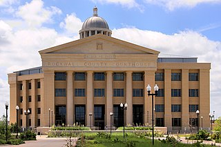
Rockwall County is a county in the U.S. state of Texas. At 149 square miles, Rockwall County has the smallest area of any Texas county. Per the 2020 Census, its population was 107,819. Its county seat is Rockwall. The county and city are named for a wall-like subterranean rock formation that runs throughout the county.

<span class="mw-page-title-main">Parker County, Texas</span> County in Texas, United States

Parker County is a county located in the U.S. state of Texas. As of the 2020 census, its population was 148,222. The county seat is Weatherford. The county was created in 1855 and organized the following year. It is named for Isaac Parker, a state legislator who introduced the bill that established the county in 1855. Parker later fought in the Texas Brigade.

<span class="mw-page-title-main">Navarro County, Texas</span> County in Texas, United States

Navarro County is a county in the U.S. state of Texas. As of the 2020 census, the population was 52,624. Its county seat is Corsicana. The county is named for José Antonio Navarro, a Tejano leader in the Texas Revolution who signed the Texas Declaration of Independence.

<span class="mw-page-title-main">Hood County, Texas</span> County in Texas, United States

Hood County is a county in the U.S. state of Texas. As of the 2020 census, the population was 61,598. Its county seat is Granbury. The county is named for John Bell Hood, a Confederate lieutenant general and the commander of Hood's Texas Brigade.

<span class="mw-page-title-main">Denton County, Texas</span> County in Texas, United States

Denton County is located in the U.S. state of Texas. As of the 2020 census, its population was 906,422, making it the seventh-most populous county in Texas. The county seat is Denton. The county, which was named for John B. Denton, was established in 1846. Denton County constitutes part of the Dallas–Fort Worth metroplex. In 2007, it was one of the fastest-growing counties in the United States.

<span class="mw-page-title-main">Fairview, Texas</span> Town in Texas, United States

Fairview is a town in Collin County, Texas, United States. It is part of the Dallas-Fort Worth metropolitan area. As of the 2017 census, the town population was 8,950. The estimated population in 2018 was 9,092. The town is adjacent to the 289-acre (1.17 km2) Heard Natural Science Museum and Wildlife Sanctuary.

<span class="mw-page-title-main">Prosper, Texas</span> Town in Texas, United States

Prosper is a town in Collin and Denton counties in the U.S. state of Texas. Prosper is located within the Dallas-Fort Worth-Arlington metropolitan area. As of the 2010 census, its population was 9,423; As of 2023, the population was 37,746.

Bartonville is a town in Denton County, Texas, United States. The population was 1,725 at the 2020 census.

<span class="mw-page-title-main">Copper Canyon, Texas</span> Town in Texas, United States

Copper Canyon is a town in Denton County, Texas, United States. The population was 1,731 in 2020. Copper Canyon is adjacent to the master-planned Lantana residential development.

<span class="mw-page-title-main">Colleyville, Texas</span> City in Texas, United States

Colleyville is a city in northeastern Tarrant County, Texas, United States, centrally located in the Dallas–Fort Worth metroplex. A wealthy suburb of the Dallas/Fort Worth area, Colleyville was originally a small farm town in the 19th century. The population was 26,057 at the 2020 census.

<span class="mw-page-title-main">Everman, Texas</span> City in Texas, United States

Everman is a city in Tarrant County, Texas, United States. Its population was 6,154 in the 2020 census, an increase over the figure of 6,108 tabulated in 2010.

<span class="mw-page-title-main">Electra, Texas</span> City in Texas, United States

Electra is a city in Wichita County, Texas, United States. It is part of the Wichita Falls metropolitan statistical area. The population was 2,292 at the 2020 census., down from 2,791 in 2010. Electra claims the title of Pump Jack Capital of Texas, a title made official by the state in 2001, and has celebrated an annual Pump Jack Festival since 2002. It was named in honor of Electra Waggoner, an heiress to the Waggoner Ranch. Electra is also known for its Grand Theatre which was refurbished and now a functioning theater.

<span class="mw-page-title-main">Alvord, Texas</span> Town in Texas, United States

Alvord is a town in Wise County, Texas, United States. The population was 1,351 in 2020.

<span class="mw-page-title-main">Boyd, Texas</span> Town in Texas, United States

Boyd is a town in Wise County, Texas, United States. The population was 1,416 in 2020. It is 30 miles (48 km) northwest of the Dallas–Fort Worth metroplex.

<span class="mw-page-title-main">Grapevine, Texas</span> City in Texas, United States

Grapevine is a city located in northeast Tarrant County, Texas, United States, with minor portions extending into Dallas County and Denton County. The population was 50,631 at the time of the 2020 census, up from 46,334 in the 2010 census. The city is located in the Mid-Cities suburban region between Dallas and Fort Worth and includes a larger portion of Dallas/Fort Worth International Airport than other cities.

<span class="mw-page-title-main">Haslet, Texas</span> City in Texas, United States

Haslet is a city in mostly Tarrant County and partly in Denton County within the Dallas–Fort Worth metroplex in the U.S. state of Texas, and is located 15 miles north of downtown Fort Worth and 20 miles south of Denton. Haslet borders Interstate 35W, U.S. Highway 287, and Alliance Airport. The population was 1,952 at the 2020 census.

<span class="mw-page-title-main">Venus, Texas</span> City in Texas, United States

Venus is a city in Johnson and Ellis counties in the U.S. state of Texas. The population was 4,361 in 2020.

<span class="mw-page-title-main">Crowley, Texas</span> Multi-county city in Texas, United States

Crowley is a city located mainly in Tarrant County in the U.S. state of Texas. The population was 18,070 at the 2020 census, up 40.8% from the 2010 census.

<span class="mw-page-title-main">Montague, Texas</span> Census-designated place & Unincorporated Community in Texas, United States

Montague is a census-designated place and unincorporated community in Montague County, Texas, United States. It is the county seat of Montague County and had an estimated population of 400 in 2000, according to the Handbook of Texas. Its population was 304 as of the 2010 census.

References

  1. "2019 U.S. Gazetteer Files". United States Census Bureau. Retrieved August 7, 2020.
  2. 1 2 U.S. Geological Survey Geographic Names Information System: Argyle, Texas
  3. "U.S. Census website". United States Census Bureau . Retrieved January 31, 2008.
  4. 1 2 "Explore Census Data". data.census.gov. Retrieved May 22, 2022.
  5. "US Gazetteer files: 2010, 2000, and 1990". United States Census Bureau. February 12, 2011. Retrieved April 23, 2011.
  6. "Geographic Identifiers: 2010 Demographic Profile Data (G001): Argyle city, Texas". United States Census Bureau . Retrieved June 28, 2012.
  7. "Census of Population and Housing". Census.gov. Retrieved June 4, 2015.
  8. "About the Hispanic Population and its Origin". www.census.gov. Retrieved May 18, 2022.