West Texas

Last updated
West Texas
West Texas Hwy 302 west of NoTrees.jpg
West of Notrees
West Texas Regional Map.png
West Texas counties in red; counties sometimes included in West Texas in pink
Country United States
State Texas
Largest city El Paso

West Texas is a loosely defined region in the U.S. state of Texas, generally encompassing the arid and semiarid lands west of a line drawn between the cities of Wichita Falls, Abilene, and Del Rio.

Contents

No consensus exists on the boundary between East Texas and West Texas. [1] While most Texans understand these terms, no boundaries are officially recognized and any two people are likely to describe the boundaries of these regions differently. The historian and geographer Walter Prescott Webb has suggested that the 98th meridian separates East and West Texas; [2] writer A.C. Greene proposed that West Texas extends west of the Brazos River. [3] Use of a single line, though, seems to preclude the use of other separators, such as an area—Central Texas. Texas is part of the American South and the American Southwest at the same time, while the semiarid and desert climates of West Texas are clearly characteristic of the American Southwest.

West Texas is often subdivided according to distinct physiographic features. The portion of West Texas that lies west of the Pecos River is often called "Far West Texas" or the "Trans-Pecos", a term introduced in 1887 by geologist Robert T. Hill. [4] The Trans-Pecos lies within the Chihuahuan Desert and is the aridest part of the state. Another part of West Texas is the Llano Estacado, a vast region of high, level plains extending into Eastern New Mexico and the Texas Panhandle. East of the Llano Estacado lies the “redbed country” of the Rolling Plains, and south of the Llano Estacado lies the Edwards Plateau. The Rolling Plains and Edwards Plateau subregions act as transitional zones between eastern and western Texas.

Climate

West Texas receives much less rainfall than the rest of Texas and has an arid or semiarid climate, requiring most of its scant agriculture to depend heavily on irrigation. [5] Northern portions of the area are irrigated with water from underground sources, such as the Ogallala Aquifer. Irrigation withdrawal, and water taken out farther north for the needs of El Paso and Juarez, Mexico, have reduced the Rio Grande to a stream in some places, even dry at times.

Parts of West Texas have rugged terrain, including many small mountain ranges, while most parts of the state are closer to sea level. The northern parts of West Texas and the higher elevations of the mountain ranges of the Trans-Pecos region are prone to occasional heavy snowfall during winter, whereas snow is less common in other areas of West Texas.

Counties

The counties of West Texas are Andrews, Bailey, Borden, Brewster, Brown, Callahan, Castro, Cochran, Coke, Coleman, Comanche, Concho, Crane, Crockett, Crosby, Culberson, Dawson, Deaf Smith, Dickens, Eastland, Ector, El Paso, Fisher, Floyd, Gaines, Garza, Glasscock, Hale, Haskell, Hockley, Howard, Hudspeth, Irion, Jeff Davis, Jones, Kent, Kimble, King, Knox, Lamb, Loving, Lubbock, Lynn, Martin, Mason, McCulloch, Menard, Midland, Mitchell, Motley, Nolan, Pecos, Presidio, Reagan, Reeves, Runnels, Schleicher, Scurry, Shackelford, Stephens, Sterling, Stonewall, Sutton, Taylor, Terrell, Terry, Throckmorton, Tom Green, Upton, Ward, Winkler, and Yoakum. [6]

Major cities

RankImage City County(ies) Population
(2023 Estimate) [7]
RegionState
16 Downtown El Paso at sunset.jpeg El Paso El Paso 678,958
210 LubbockSkyline2013.jpg Lubbock Lubbock 266,878
325 Midland44 Skyline.jpg Midland Midland, Martin 138,397
429 Abilene-skyline.jpg Abilene Taylor, Jones 129,043
534 Downtown Odessa.jpg Odessa Ector, Midland 115,743
643 SanAngeloParkConcho.jpg San Angelo Tom Green 99,262
795 Socorro mission front.jpg Socorro El Paso 38,238
8133 Horizon City.jpg Horizon City El Paso 24,168
9140 Big Spring 1.jpg Big Spring Howard 22,373
10155 Plainview Texas City Hall 2019.jpg Plainview Hale 19,420

Smaller West Texas cities and towns include Alpine, Andrews, Anthony, Brownfield, Canutillo, Coyanosa, Crane, Fabens, Fort Davis, Fort Stockton, Hale Center, Horizon City, Iraan, Kermit, Lamesa, Levelland, Littlefield, Marathon, Marfa, McCamey, Mertzon, Monahans, Ozona, Pecos, Post, Rankin, San Elizario, Seminole, Slaton, Snyder, Sweetwater, and Van Horn.

Economy

Major industries include livestock, petroleum and natural gas production, textiles such as cotton, grain, and because of very large military installations such as Fort Bliss, the defense industry. West Texas has become notable for its numerous wind turbines producing clean and alternative electricity.

As of 2018, the West Texan economy was in a prosperous economic period, which has been described as the "West Texas oil boom". [8] [9]

Sports

While there are no major league teams in the West Texas region, sports fans are faithful to their local high school and college teams. NCAA Division I college teams include the Texas Tech Red Raiders, and the UTEP Miners. NCAA Division II teams include the West Texas A&M Buffaloes, the Texas–Permian Basin Falcons, and the Lubbock Christian Chaparrals and Lady Chaps.

El Paso hosts the El Paso Chihuahuas, a AAA baseball team, and the El Paso Locomotive FC which plays in the USL Championship, the second tier of the American soccer pyramid. The Midland RockHounds and Amarillo Sod Poodles represent the region in double-A baseball. Junior hockey is also present in the region, with the Odessa Jackalopes of the Tier II North American Hockey League.

Politics

2020 U.S. presidential election in Texas results by county Texas Presidential Election Results 2020.svg
2020 U.S. presidential election in Texas results by county

Except for the Trans-Pecos region, West Texas has become well known as a stronghold for conservative politics. Some of the most heavily Republican counties in the United States are in the region. Former U.S. President George W. Bush spent most of his childhood in West Texas.

The region is part of the Permian Basin, the highest producing oil field in the United States. [10] This likely inclines the region to support the Republican Party over the Democratic Party, as the latter supports environmentalism and action on climate change. [11] [12]

Several counties in the Midland-Odessa area were some of the first parts of Texas to abandon the state's "Solid South" Democratic roots; two counties [lower-alpha 1] have not supported a Democrat for president since 1948. The Rolling Plains to the east remained Democratic substantially longer: although Walter Mondale's 1984 campaign lost Texas by 27.50%, he won three counties in this region. [lower-alpha 2] Since 2000, this region swung very rapidly toward the Republican Party due to its population's intransigent opposition to the liberal social policies of the Democratic Party, [13] and by 2016, it had nearly the same Cook PVI as the Panhandle.

"West of the Pecos" has become a metaphor for the universe of Westerns. "Fastest draw west of the Pecos" and similar superlatives are a cliche, and the title character of Chisum observed "There’s no law west of Dodge, and no God west of the Pecos”.

Cormac McCarthy's novel No Country for Old Men and its subsequent film adaptation take place in West Texas, and much of the movie was filmed there.

See also

Related Research Articles

<span class="mw-page-title-main">Pecos County, Texas</span> County in Texas, United States

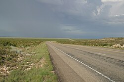
Pecos County is a county located in the U.S. state of Texas. As of the 2020 census, its population was 15,193. The county seat is Fort Stockton. The county was created in 1871 and organized in 1875. It is named for the Pecos River. It is one of the nine counties that comprise the Trans-Pecos region of West Texas.

<span class="mw-page-title-main">Big Spring, Texas</span> City in Texas, United States

Big Spring is a city in and the county seat of Howard County, Texas, United States, at the crossroads of U.S. Highway 87 and Interstate 20. With a population of 27,282 as of the 2010 census, it is the largest city between Midland to the west, Abilene to the east, Lubbock to the north, and San Angelo to the south. Big Spring was established as the county seat of Howard County in 1882; it is the largest community in the county.

<span class="mw-page-title-main">Fort Stockton, Texas</span> City in Texas, United States

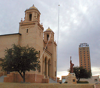
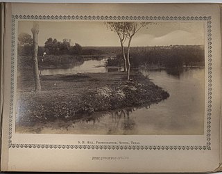
Fort Stockton is a city in and the county seat of Pecos County, Texas, United States. It is located on Interstate 10, future Interstate 14, U.S. Highways 67, 285, and 385, and the Santa Fe Railroad, 329 mi (529 km) northwest of San Antonio and 240 mi (390 km) southeast of El Paso. Its population was 8,466 at the 2020 census.

<span class="mw-page-title-main">Llano Estacado</span> Southwestern United States in New Mexico and Texas

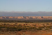
The Llano Estacado, sometimes translated into English as the Staked Plains, is a region in the Southwestern United States that encompasses parts of eastern New Mexico and northwestern Texas. One of the largest mesas or tablelands on the North American continent, the elevation rises from 3,000 feet (900 m) in the southeast to over 5,000 feet (1,500 m) in the northwest, sloping almost uniformly at about 10 feet per mile (2 m/km).

<span class="mw-page-title-main">Sierra Madera crater</span>

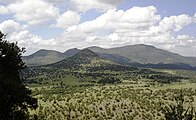
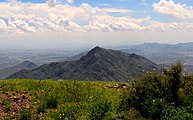
Sierra Madera crater is a meteorite crater (astrobleme) in southwestern Pecos County, Texas, United States. The central peak of the rebound structure of the impact crater rises 793 ft (242 m) above the surrounding land. The peak is visible from U.S. Highway 385 between Fort Stockton, Texas and Marathon, Texas. The Sierra Madera crater is located on private property on the La Escalera Ranch.

<span class="mw-page-title-main">South Plains</span> Region in Texas, United States

The South Plains is a region in northwest Texas, consisting of 24 counties. The main crop is cotton.

<span class="mw-page-title-main">High Plains (United States)</span> Subregion of the Great Plains, mainly in the Western United States

The High Plains are a subregion of the Great Plains, mainly in the Western United States, but also partly in the Midwest states of Nebraska, Kansas, and South Dakota, generally encompassing the western part of the Great Plains before the region reaches the Rocky Mountains. The High Plains are located in eastern Montana, southeastern Wyoming, southwestern South Dakota, western Nebraska, eastern Colorado, western Kansas, eastern New Mexico, the Oklahoma Panhandle, and the Texas Panhandle. The southern region of the Western High Plains ecology region contains the geological formation known as Llano Estacado which can be seen from a short distance or on satellite maps. From east to west, the High Plains rise in elevation from around 1,800 to 7,000 ft.

<span class="mw-page-title-main">Midland–Odessa</span> Metropolitan area in West Texas

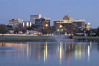
Midland–Odessa is a metropolitan area located in The Texas Plains approximately half-way between El Paso and Fort Worth, Texas. This combined statistical area (CSA) is made up of two metropolitan statistical areas and one micropolitan statistical area, and comprises four counties: Andrews, Ector, Martin, and Midland counties. The Midland–Odessa area is informally known as The Petroplex.

<span class="mw-page-title-main">Trans-Pecos</span> Far west region in US state of Texas

The Trans-Pecos, as originally defined in 1887 by the Texas geologist Robert T. Hill, is the distinct portion of Texas that lies west of the Pecos River. The term is considered synonymous with Far West Texas, a subdivision of West Texas. The Trans-Pecos is part of the Chihuahuan Desert, the largest desert in North America. It is the most mountainous and arid portion of the state, and most of its vast area is sparsely populated. Among the nine counties in the region are the five largest counties by area in Texas and eight of the eleven largest in the state. The area is known for the natural environment of the Big Bend and the gorge of the Rio Grande, part of which has been designated a National Wild and Scenic Rivers System. With the notable exceptions of Big Bend Ranch State Park, Big Bend National Park and the Guadalupe Mountains National Park, the vast majority of the Trans-Pecos region consists of privately owned ranchland. However, most of the region's population reside in the El Paso metropolitan area. Besides El Paso and its metropolitan area, the major cities are Pecos (12,916), Fort Stockton (8,466), and Alpine (6,035). All other settlements have under 5,000 people.

<span class="mw-page-title-main">Eastern New Mexico</span> Region in New Mexico, United States

Eastern New Mexico is a physiographic subregion within the U.S. state of New Mexico. The region is sometimes called the "High Plains," or "Eastern Plains ," and was historically referred to as part of the "Great American Desert". The region is largely coterminous with the portion of the Llano Estacado in New Mexico. Portions of Eastern New Mexico's elevation extend to over 4,000 ft (1,200 m). The region is characterized by flat, largely featureless terrain with the exception of the Pecos River valley and the abrupt breaks along the Mescalero Ridge and northern caprock escarpments of the Llano Estacado. The region typically lacks the high relief of central and northern New Mexico, such as that in the Sangre de Cristo and Sandia mountain ranges. The climate is semi-arid with hot summers and is characterized by significant wind and dust storms in the springtime.

<span class="mw-page-title-main">Geography of Texas</span> Geographical features of Texas

The geography of Texas is diverse and large. Occupying about 7% of the total water and land area of the U.S., it is the second largest state after Alaska, and is the southernmost part of the Great Plains, which end in the south against the folded Sierra Madre Oriental of Mexico. Texas is in the South Central United States of America, and is considered to form part of the U.S. South and also part of the U.S. Southwest.

<span class="mw-page-title-main">Texas wine</span> Wine made from grapes grown in Texas, United States

Texas has a long history of wine production. The sunny and dry climate of the major winemaking regions in the state have drawn comparison to Portuguese wines, in addition to other regions in Europe like Spain, France, and Italy. Some of the earliest recorded Texas wines were produced by Spanish missionaries in the 1650s near El Paso. Texas ranked as the fifth largest wine producing state by 2019.

<span class="mw-page-title-main">Butterfield Overland Mail in Texas</span> Route of mail service created in 1857

In Texas, the Butterfield Overland Mail service created by Congress on March 3, 1857, was operated until March 30, 1861.

<span class="mw-page-title-main">Becton, Texas</span> Unincorporated community in Texas, United States

Becton is an unincorporated community in northeastern Lubbock County, Texas, United States, approximately 18 mi (29 km) northeast of Lubbock. This small rural community lies on the high plains of the Llano Estacado in West Texas.

<span class="mw-page-title-main">Paleontology in Texas</span> Paleontological research in U.S

Paleontology in Texas refers to paleontological research occurring within or conducted by people from the U.S. state of Texas. Author Marian Murray has said that "Texas is as big for fossils as it is for everything else." Some of the most important fossil finds in United States history have come from Texas. Fossils can be found throughout most of the state. The fossil record of Texas spans almost the entire geologic column from Precambrian to Pleistocene. Shark teeth are probably the state's most common fossil. During the early Paleozoic era Texas was covered by a sea that would later be home to creatures like brachiopods, cephalopods, graptolites, and trilobites. Little is known about the state's Devonian and early Carboniferous life. Evidence indicates that during the late Carboniferous the state was home to marine life, land plants and early reptiles. During the Permian, the seas largely shrank away, but nevertheless coral reefs formed in the state. The rest of Texas was a coastal plain inhabited by early relatives of mammals like Dimetrodon and Edaphosaurus. During the Triassic, a great river system formed in the state that was inhabited by crocodile-like phytosaurs. Little is known about Jurassic Texas, but there are fossil aquatic invertebrates of this age like ammonites in the state. During the Early Cretaceous local large sauropods and theropods left a great abundance of footprints. Later in the Cretaceous, the state was covered by the Western Interior Seaway and home to creatures like mosasaurs, plesiosaurs, and few icthyosaurs. Early Cenozoic Texas still contained areas covered in seawater where invertebrates and sharks lived. On land the state would come to be home to creatures like glyptodonts, mammoths, mastodons, saber-toothed cats, giant ground sloths, titanotheres, uintatheres, and dire wolves. Archaeological evidence suggests that local Native Americans knew about local fossils. Formally trained scientists were already investigating the state's fossils by the late 1800s. In 1938, a major dinosaur footprint find occurred near Glen Rose. Pleurocoelus was the Texas state dinosaur from 1997 to 2009, when it was replaced by Paluxysaurus jonesi after the Texan fossils once referred to the former species were reclassified to a new genus.

<span class="mw-page-title-main">Comanche Springs (Texas)</span>

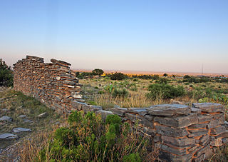
Comanche Springs was an aquifer of six artesian springs geographically located between the Edwards Plateau and the Trans-Pecos regions of West Texas. The military fortification Camp Stockton was built around the springs, eventually growing become the city of Fort Stockton.

Pope's Crossing was a ford on the Pecos River located one mile south of the New Mexico–Texas border on the modern Loving–Reeves county line. Discovered by members of an 1855 expedition tasked with drilling artesian wells east of the Pecos led by U.S. Army topographical engineer John Pope, the ford quickly became the primary crossing of the river on the "upper" military or emigrant road between San Antonio and the ford on the Rio Grande opposite the Mexican town of El Paso del Norte. Heavily used by emigrants, soldiers, traders, and freighters eager to avoid the more difficult and unpredictable crossings further south, Pope's Crossing became a well-traveled part of the network of transcontinental wagon roads that developed across Texas in the 1850s to facilitate settlement and commerce in the southwestern lands recently acquired as a result of the Mexican–American War.

References

  1. Cochran, M., Lumpkin, J. and Heflin, R. 1999. West Texas: a portrait of its people and their raw and wondrous land. Lubbock: Texas Tech University Press, 176 pp.
  2. Webb, W.P. 1935. The Texas Rangers: a century of frontier defense. New York: Houghton Mifflin Co., 583 pp.
  3. Greene, A.C. 1998. Sketches from the five states of Texas. College Station: Texas A&M University Press, 176 pp.
  4. Hill, R.T. 1887. The topography and geology of the Cross Timbers and surrounding regions in Northern Texas. The American Journal of Science, 3rd Series, 33:291–303.
  5. Bubenik, Travis (2018-04-15). "Texas Could Look Increasingly Like West Texas, Climate Study Says". Houston Public Media. Retrieved 2020-10-20.
  6. "The Regions of Texas". Texas Counties.net. Retrieved 13 October 2014.
  7. "Annual Estimates of the Resident Population for Incorporated Places in Texas: April 1, 2020 to July 1, 2023 (SUB-IP-EST2023-POP-48)" (XLSX). United States Census Bureau, Population Division. May 16, 2024. Retrieved May 23, 2024.
  8. Clifford, Krauss (March 28, 2018). "$9.5 Billion Purchase by Concho Is Latest Sign of West Texas Oil Boom". The New York Times . Retrieved May 15, 2018.
  9. Saphir, Ann (May 1, 2018). "Boom in West Texas oil patch lifts wages, prices". Reuters. Retrieved May 15, 2018.
  10. US Department of Energy (November 2018). "Permian Basin Geology Review" (PDF). Archived (PDF) from the original on February 26, 2021.
  11. Tabuchi, Hiroko (October 16, 2019). "Despite Their Promises, Giant Energy Companies Burn Away Vast Amounts of Natural Gas". The New York Times. ISSN   0362-4331. Archived from the original on June 5, 2021. Retrieved October 17, 2019.
  12. Storrow, Benjamin (5 May 2020). "Methane Leaks Erase Some of the Climate Benefits of Natural Gas". Scientific American . Archived from the original on 27 April 2022.
  13. Cohn, Nate; 'Demographic Shift: Southern Whites' Loyalty to G.O.P. Nearing That of Blacks to Democrats', New York Times , April 24, 2014

Notes

  1. West Texas counties voting Republican at every election since 1952 comprise Ector County, Midland County.
  2. West Texas Plains "Bible Belt" counties voting for Mondale in 1984 were Dickens County, Fisher County, and Stonewall County.