Horizon City, Texas

Last updated

Horizon City, Texas
Horizon City.jpg
Horizon City Town Hall
TXMap-doton-HorizonCity.PNG
Location of Horizon City, Texas
ElPaso County HorizonCity.svg
Coordinates: 31°40′56″N106°11′46″W / 31.68222°N 106.19611°W / 31.68222; -106.19611
Country United States
State Texas
County El Paso
Founded1962
IncorporatedOctober 22, 1988
Government
  TypeMayor-council
   Mayor Ruben Mendoza
Area
[1]
  Total8.72 sq mi (22.58 km2)
  Land8.71 sq mi (22.57 km2)
  Water0.01 sq mi (0.01 km2)
Elevation
4,022 ft (1,226 m)
Population
 (2020)
  Total22,489
  Density2,254.07/sq mi (870.30/km2)
Demonym Horizonite
Time zone UTC-7 (Mountain (MST))
  Summer (DST) UTC-6 (MDT)
ZIP codes
79927-79928
Area code 915
FIPS code 48-34832 [2]
GNIS feature ID1359564 [3]
Website www.horizoncity.org

Horizon City is a city in El Paso County, Texas, United States. As of the 2020 United States Census, its population was 22,489, reflecting an increase of 5,754 from the 16,735 counted in the 2010 Census. [4]

Contents

Climate

Geography

Horizon City is located at 31°40′56″N106°11′46″W / 31.68222°N 106.19611°W / 31.68222; -106.19611 (31.682315, −106.196127). [5]

According to the United States Census Bureau, the city has a total area of 8.7 square miles (22.6 km2), all land. [4]

Government

The mayor of Horizon City is Ruben Mendoza. The legislative and governing body of the City consists of a Mayor and seven Council Members. The Mayor and council are elected to four-year terms. The next election for Mayor and Council Members for places 3, 5, and 7 will be in May 2023; the election for Council Members for places 1, 2, 4, and 6 will be in May 2025. The current city council members of Horizon City are Walter Miller, Scott Quiroz, Charlie Ortega, Andres (Andy) Renteria, Johnny "Doc" Duran, Rafael (Ralph) Padilla Jr., and Samantha S. Corral. [6]

Economic development

Horizon City formed an economic development corporation in 2011. The corporation has the power to use sales tax funds to help eligible companies with relocations, expansions, and site development. It can acquire property, finance infrastructure projects, and spend funds for a variety of quality-of-life improvements. [7]

History

The city, incorporated by referendum on October 22, 1988, [8] [9] takes its name from the real-estate development corporation that developed it as a planned community beginning in the early 1960s, the Horizon Corporation. The Horizon Corporation bought up large tracts of land in the southwestern United States, including eastern El Paso County, platted them into subdivisions, and sold lots in them to thousands of people worldwide, often sight unseen, often without access to water or utilities and using questionable sales tactics, between 1962 and 1975. Eventually, the Federal Trade Commission stepped in to stop it in 1981. [10] [11] Only one portion of the development was successful, the area around the intersection of Horizon Boulevard (Farm to Market Road 1281) and Kenazo Street; this became the nucleus of Horizon City.

Much of the land to the east of town consists of undeveloped subdivisions with highly fragmented ownership. The lots in these subdivisions cannot be legally sold and will be difficult to develop due to the 1994 Texas Colonia Act, a state law intended to stop the development of colonias, or neighborhoods underserved by utilities whose residents often live in substandard conditions. It forbids the sale for residential purposes of less than 10 acres of land or the sale of more than 10 acres of land without a guarantee of adequate access to water, sewer services and other utilities. Efforts are currently underway by a local homeowners' association, the Horizon Communities Improvement Association, to assemble these lots into tracts of land that can be legally developed. [10] [12]

Demographics

Historical population
CensusPop.Note
1990 2,308
2000 5,233126.7%
2010 16,735219.8%
2020 22,48934.4%

2020 census

Horizon City racial composition [13]
(NH = Non-Hispanic) [lower-alpha 1]
RaceNumberPercentage
White (NH)1,5006.67%
Black or African American (NH)2851.27%
Native American or Alaska Native (NH)420.19%
Asian (NH)510.23%
Pacific Islander (NH)180.08%
Some Other Race (NH)530.24%
Mixed/Multi-Racial (NH)1480.66%
Hispanic or Latino 20,39290.68%
Total22,489

As of the 2020 United States census, there were 22,489 people, 5,940 households, and 5,011 families residing in the city. The population density was 1,921.6 inhabitants per square mile (741.9/km2). The 5,490 housing units had an average density of 584.1 per square mile (225.5/km2).

2010 census

According to the 2010 Census, of the 4,733 households, 64.2% had children under 18 living with them, 66.8% were headed by married couples living together, 14.7% had a female householder with no husband present, and 13.8% were not families. About 10.8% of all households were made up of individuals, and 2.4% were someone living alone who was 65 years of age older. The average household size was 3.54, and the average family size was 3.83. [16]

In the city, the age distribution was 38.2% under the age of 18, 9.2% from 18 to 24, 32.1% from 25 to 44, 16.0% from 45 to 64, and 4.5% who were 65 or older. The median age was 26.6 years. For every 100 females, there were 94.6 males. For every 100 females age 18 and over, there were 89.2 males. [16]

For the year 2019, the estimated median annual income for a household in the city was $60,431. The per capita income for the city was $21,507. About 13.3% of the population was below the poverty line. [4]

Education

Horizon City is served by the Clint and Socorro Independent School Districts. [17]

The Socorro Independent School District serves the city center and adjacent neighborhoods on the west end of town; the boundary between it and the Clint Independent School District to the east is located at or near Kenazo Street.

Schools serving Horizon City

Clint Independent School District campuses

Socorro Independent School District campuses

The zoned schools are:

Other

  • Pete Duarte Head Start Center (Texas Education Agency, Region 19) [Pre-K]

Government and infrastructure

The Texas Department of Criminal Justice operates the El Paso II District Parole Office in an unincorporated area east of Horizon City. [21]

Related Research Articles

<span class="mw-page-title-main">El Paso County, Texas</span> County in Texas, United States

El Paso County is the westernmost county in the U.S. state of Texas. As of the 2020 census, the population was 865,657, making it the ninth-most populous county in the state of Texas. Its seat is the city of El Paso, the sixth-most populous city in Texas and the 22nd-most populous city in the United States. The county was created in 1850 and later organized in 1871.

<span class="mw-page-title-main">Anthony, New Mexico</span> City in New Mexico, United States

Anthony is a city in Doña Ana County, New Mexico, United States. The population was 9,360 at the 2010 census. It is located on the New Mexico–Texas state line in the Upper Mesilla Valley, and on Interstate 10, 24 miles south of Las Cruces and 18 miles north of El Paso, Texas.

<span class="mw-page-title-main">Socorro, New Mexico</span> City in New Mexico, United States

Socorro is a city in Socorro County in the U.S. state of New Mexico. It is in the Rio Grande Valley at an elevation of 4,579 feet (1,396 m). In 2010 the population was 9,051. It is the county seat of Socorro County. Socorro is located 74 miles (119 km) south of Albuquerque and 146 miles (235 km) north of Las Cruces.

<span class="mw-page-title-main">Freeport, Texas</span> City in Texas, United States

Freeport is a city in Brazoria County, Texas, United States, located on the Gulf of Mexico. According to the 2020 census, the city population was 10,696, down from 12,049 in 2010.

<span class="mw-page-title-main">Celina, Texas</span> City in Texas, United States

Celina is a city in Collin and Denton counties in the U.S. state of Texas. Celina is part of the Dallas–Fort Worth metroplex.

<span class="mw-page-title-main">The Colony, Texas</span> City in Texas, United States

The Colony is a city in Denton County, Texas, United States, and a suburb of Dallas. The population was 44,534 at the 2020 census.

<span class="mw-page-title-main">Homestead Meadows North, Texas</span> Census-designated place in Texas, United States

Homestead Meadows North is a census-designated place (CDP) in El Paso County, Texas, United States. The population was 5,124 at the 2010 census. It is part of the El Paso Metropolitan Statistical Area. The ZIP Code encompassing the CDP area is 79938.

<span class="mw-page-title-main">San Elizario, Texas</span> City in Texas, United States

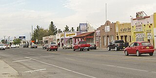
San Elizario is a city in El Paso County, Texas, United States. Its population was 13,603 at the 2010 census. It is part of the El Paso metropolitan statistical area. It lies on the Rio Grande, which forms the border between the United States and Mexico. The city of Socorro adjoins it on the west and the town of Clint lies to the north.

<span class="mw-page-title-main">Socorro, Texas</span> City in Texas, United States

Socorro is a city in El Paso County, Texas, United States. It is located on the north bank of the Rio Grande southeast of El Paso, and on the border of Mexico. El Paso adjoins it on the west and the smaller city of San Elizario on the southeast; small unincorporated areas of El Paso County separate it from the nearby municipalities of Horizon City to the north and Clint to the east. As of the 2020 census, the city population was 34,306. By the 2010 census, the number had grown to 32,013. As of July 1, 2019, the population estimate for the city from the U.S. Census was 34,370. It is part of the El Paso Metropolitan Statistical Area. The city is El Paso County's second-largest municipality, after El Paso. It has a council-manager type of government with five city council members. Socorro is the 93rd-largest community in Texas.

<span class="mw-page-title-main">Sparks, Texas</span> Census-designated place in Texas, United States

Sparks is a census-designated place (CDP) in El Paso County, Texas, United States. The population was 4,529 at the 2010 census. It is part of the El Paso Metropolitan Statistical Area. The ZIP Code encompassing the CDP area is 79928.

<span class="mw-page-title-main">Westway, Texas</span> Census-designated place in Texas, United States

Westway is a census-designated place (CDP) in El Paso County, Texas, United States. The population was 4,188 at the 2010 census. It is part of the El Paso Metropolitan Statistical Area. It is located east of Interstate 10, approximately 2 miles (3 km) from the New Mexico - Texas state line. The ZIP Code encompassing the CDP area is 79835.

<span class="mw-page-title-main">Oak Ridge North, Texas</span> City in Montgomery County, Texas, United States

Oak Ridge North is a city in Montgomery County, Texas, United States. It is located along Interstate 45 10 miles (16 km) south of Conroe and 35 miles north of Houston. The population was 3,057 at the 2020 census.

<span class="mw-page-title-main">Woodbranch, Texas</span> City in Texas, United States

Woodbranch Village, also known simply as "Woodbranch," is a city in Montgomery County, Texas, United States. The population was 1,330 at the 2020 census.

<span class="mw-page-title-main">Kennedale, Texas</span> City in Texas, United States

Kennedale is a city in Tarrant County, Texas, United States. The city had a population of 8,543 as of 2018.

<span class="mw-page-title-main">Garfield, Texas</span> CDP in Texas, United States

Garfield is a census-designated place (CDP) in Travis County, Texas, United States. As of the 2020 census, the CDP population was 1,825.

The Socorro Independent School District (SISD) serves more than 47,000 students in 49 schools and is the second largest school district in El Paso, Texas. The district covers 135 square miles serving East El Paso, Horizon City and the City of Socorro. SISD is well known as a destination district for its high-quality instruction, innovative programs, and a supportive and united community. The district operates on a year-round calendar from July to May with a fall and spring intersession.

<span class="mw-page-title-main">Clint Independent School District</span> School district in Texas, United States

Clint Independent School District is a public school district in eastern El Paso County, Texas (US).

El Dorado High School is a public high school located in El Paso, Texas, United States.

<span class="mw-page-title-main">El Paso metropolitan area</span> Metropolitan statistical area in Texas, United States

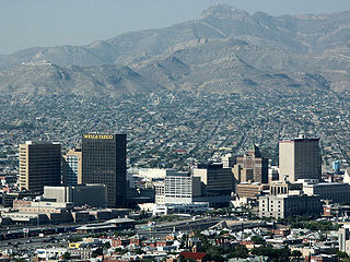
The El Paso Metropolitan Statistical Area, as defined by the United States Census Bureau, is an area consisting of two counties – El Paso and Hudspeth – in far West Texas, anchored by the city of El Paso. As of the 2020 United States Census, the MSA had a population of 868,859. The El Paso MSA forms part of the larger El Paso–Las Cruces combined statistical area, with a total population of 1,088,420 as of the 2020 United States Census.

<span class="mw-page-title-main">Socorro High School (Socorro, Texas)</span> Public school in Texas, United States

Socorro High School is a public high school in Socorro, of El Paso County, Texas, United States. It was named a National Blue Ribbon School in 1994–1996.

References

  1. "2019 U.S. Gazetteer Files". United States Census Bureau. Retrieved August 7, 2020.
  2. "U.S. Census website". United States Census Bureau . Retrieved January 31, 2008.
  3. "US Board on Geographic Names". United States Geological Survey. October 25, 2007. Retrieved January 31, 2008.
  4. 1 2 3 "US Census QuickFacts Horizon City Texas". United States Census Bureau . Retrieved February 18, 2022.
  5. "US Gazetteer files: 2010, 2000, and 1990". United States Census Bureau. February 12, 2011. Retrieved April 23, 2011.
  6. "Horizon City Mayor and Council". Town of Horizon City. Retrieved February 18, 2022.
  7. "Home". Horizon EDC.
  8. Mattox, Jim (April 3, 1989). "Texas Attorney General Opinion: LO89-25". The Portal to Texas History.
  9. "Archived copy" (PDF). Archived from the original (PDF) on March 21, 2017. Retrieved July 27, 2014.{{cite web}}: CS1 maint: archived copy as title (link)
  10. 1 2 "Horizon lots sit undeveloped;owners unable to sell". Archived from the original on August 27, 2015. Retrieved August 7, 2023.
  11. "Ad scams prey on Horizon lot owners". Archived from the original on May 12, 2015. Retrieved August 7, 2023.
  12. "Horizon Communities Improvement Association". Horizon Communities Improvement Association.
  13. "Explore Census Data". data.census.gov. Retrieved May 19, 2022.
  14. "Census.gov". Census.gov.
  15. "About the Hispanic Population and its Origin". www.census.gov. Retrieved May 18, 2022.
  16. 1 2 "Profile of General Population and Housing Characteristics: 2010 Demographic Profile Data (DP-1): Horizon city, Texas". U.S. Census Bureau, American Factfinder. Archived from the original on February 12, 2020. Retrieved January 11, 2013.
  17. "2020 CENSUS - SCHOOL DISTRICT REFERENCE MAP: El Paso County, TX" (PDF). U.S. Census Bureau . Retrieved June 29, 2022. - See block map
  18. "SISD High School Attendance Boundaries". Socorro Independent School District . Retrieved July 4, 2022. - Zoom on Eastlake Zone.
  19. "SISD Middle School Attendance Boundaries". Socorro Independent School District . Retrieved July 4, 2022. - Zoom on Ensor zone
  20. "SISD Elementary School Attendance Boundaries". Socorro Independent School District . Retrieved July 4, 2022. - Zoom on Horizon Heights zone
  21. "Parole Division Region V Archived 2010-01-25 at the Wayback Machine ." Texas Department of Criminal Justice. Retrieved on May 22, 2010.
  1. Note: the US Census treats Hispanic/Latino as an ethnic category. This table excludes Latinos from the racial categories and assigns them to a separate category. Hispanics/Latinos can be of any race. [14] [15]