San Elizario, Texas

Last updated
San Elizario, Texas
Statue of William Bonney, or "Billy the Kid," in the arts district of little San Elizario, near El Paso, Texas LCCN2014630950.tif
Statue of William Bonney, or "Billy the Kid," in the arts district of little San Elizario, near El Paso, Texas
TXMap-doton-SanElizario.PNG
Location of San Elizario, Texas
ElPaso County SanElizario.svg
Coordinates: 31°34′58″N106°15′57″W / 31.58278°N 106.26583°W / 31.58278; -106.26583 Coordinates: 31°34′58″N106°15′57″W / 31.58278°N 106.26583°W / 31.58278; -106.26583
Country United States
State Texas
County El Paso
Incorporated November 5, 2013
Government
  TypeMayor-council
  MayorIsela Reyes
Area
[1]
  Total6.89 sq mi (17.83 km2)
  Land6.88 sq mi (17.83 km2)
  Water0.00 sq mi (0.01 km2)
Elevation
3,642 ft (1,110 m)
Population
 (2010)
  Total13,603
  Estimate 
(2019) [2]
9,089
  Density1,320.50/sq mi (509.87/km2)
Time zone UTC-7 (Mountain (MST))
  Summer (DST) UTC-6 (MDT)
ZIP code
79849
Area code 915
FIPS code 48-65360 [3]
GNIS feature ID1367493 [4]
Website cityofsanelizario.com

San Elizario is a city in El Paso County, Texas, United States. Its population was 13,603 at the 2010 census. [5] It is part of the El Paso metropolitan statistical area. It lies on the Rio Grande, which forms the border between the United States and Mexico. The city of Socorro adjoins it on the west and the town of Clint lies to the north.

Contents

History

La Toma: The Official Act of Possession

In 1598, Don Juan de Oñate, a Spanish nobleman and conquistador born in Zacatecas, Mexico, led a group of 539 colonists and 7,000 head of livestock (including horses, oxen, and cattle) from southern Chihuahua to settle the province of New Mexico. The caravan traveled a northeasterly route for weeks across the desert until it reached the banks of the Rio Grande in the San Elizario area. A mass was held, a blessing of the standard and a celebration. Oñate performed the ceremony of La Toma ("Taking Possession"), in which he claimed the new province for King Philip II of Spain. This is considered to be the "Birth of the American Southwest".

Hacienda de los Tiburcios

The settlement that became San Elizario was first established sometime before 1760 as the civilian settlement of Hacienda de los Tiburcios. The hacienda was located along the route of Camino Real de Tierra Adentro southeast of Socorro on the west bank of the Rio Grande. The hacienda was eventually abandoned by the 1770s. [6] :46–47

Presidio San Elzeario

In 1789, the site of the old hacienda Tiburcios became the new site where the Spaniards relocated a fort called Presidio de San Elzeario. It had originally been established in 1774, located farther south in the El Paso Valley near the site of modern El Porvenir. It had been moved north to be better able to protect the Camino Real and the towns of to its north, Socorro and Ysleta. [6] :46

The town that grew up around the presidio took its name San Elzeario, or San Elceario (Spanish for Saint Elzear); Saint Elzéar of Sabran is the Roman Catholic patron saint of soldiers. After the Americans acquired the town at the end of the Mexican American War, its name was Americanized as San Elizario. [7] [8] [6] :46–47

San Elizario

San Elizario was El Paso County's original county seat.

Salt War

In 1877, a conflict, the Salt War, broke out between the town and a troop of Texas Rangers. The Rangers surrendered and two were massacred by the local population. The perpetrators then fled into Mexico and the town lost much of its status.

Incorporation

San Elizario was incorporated several times between 1871 and 1911, with another unsuccessful attempt at incorporation made in 1986. [9] On November 5, 2013, San Elizario residents voted to re-incorporate the town, having successfully fought off an attempt by Socorro to annex a portion of it, and San Elizario was officially incorporated when El Paso County Judge Veronica Escobar signed an order of incorporation on November 18, 2013. [10]

On May 10, 2014, Maya Sanchez, who led the push to incorporate San Elizario, was elected mayor by a wide margin over two other candidates, while Leticia Hurtado-Miranda, David Cantu, Miguel Najera, Jr., Rebecca Martinez-Juarez, and George Almanzar were elected to the five city council seats. [9]

Geography

San Elizario is located at 31°34′58″N106°15′57″W / 31.58278°N 106.26583°W / 31.58278; -106.26583 (31.582873, –106.265703), right next to the river. [11]

According to the United States Census Bureau, the city has a total area of 6.885 square miles (17.833 km2), of which 0.0027 square miles (0.007 km2) is covered by water. [5]

Demographics

Historical population
CensusPop.Note
2000 11,046
2010 13,60323.1%
2019 (est.)9,089 [2] −33.2%
U.S. Decennial Census [12]

2020 census

San Elizario racial composition [13]
(NH = Non-Hispanic) [lower-alpha 1]
RaceNumberPercentage
White (NH)1621.6%
Black or African American (NH)220.22%
Native American or Alaska Native (NH)190.19%
Asian (NH)10.01%
Some Other Race (NH)180.18%
Mixed/Multi-Racial (NH)210.21%
Hispanic or Latino 9,87397.6%
Total10,116

As of the 2020 United States census, there were 10,116 people, 2,435 households, and 2,168 families residing in the city.

2000 census

As of the census [3] of 2000, 11,046 people, 2,624 households, and 2,440 families resided in the CDP. The population density was 1,112.8 inhabitants per square mile (429.7/km2). There were 2,809 housing units at an average density of 283.0 per square mile (109.3/km2). The racial makeup of the CDP was 94.34% White, 0.15% African American, 5.55% Native American, 0.01% Asian, 0.01% Pacific Islander, 4.18% from other races, and 0.76% from two or more races. Hispanics or Latinos of any race were 97.88% of the population. Of those 98.88% who identify themselves as Hispanic, 95.02% identify themselves as Mexican, making San Elizario the most Mexican (though not Hispanic, see Mila Doce, Texas) town in the United States.

Of the 2,624 households, 67.3% had children under the age of 18 living with them, 73.8% were married couples living together, 15.2% had a female householder with no husband present, and 7.0% were not families. About 6.3% of all households were made up of individuals, and 2.1% had someone living alone who was 65 years of age or older. The average household size was 4.21 and the average family size was 4.40.

In the CDP, the population was distributed as 42.3% under the age of 18, 11.0% from 18 to 24, 28.6% from 25 to 44, 13.4% from 45 to 64, and 4.7% who were 65 years of age or older. The median age was 22 years. For every 100 females, there were 99.4 males. For every 100 females age 18 and over, there were 94.4 males.

The median income for a household in the CDP was $20,145, and for a family was $20,772. Males had a median income of $16,689 versus $12,648 for females. The per capita income for the CDP was $5,915. About 40.2% of families and 44.5% of the population were below the poverty line, including 51.8% of those under age 18 and 20.3% of those age 65 or over.

Education

San Elizario is served by the San Elizario Independent School District.

San Elizario Chapel

San Elizario Chapel (La Capilla de San Elcear) was never a mission, but it functioned as a presidio chapel. It provided the religious needs of a presidio or outpost of military personnel. The presidio was moved to the present site in 1789, to protect travelers and settlers along the Camino Real (Royal Highway) [16] which ran from Mexico City through Ciudad Juárez, then called "Paso del Norte", to Santa Fe, New Mexico. Its close proximity to the Ysleta and Socorro missions also provided protection for them.

When Mexico became independent from Spain in 1821, the military presence at the presidio decreased. By 1848, the presidio had fallen into ruins. Rebuilding efforts began in 1853, with a small church. This proved inadequate, and the present structure was completed in 1882. The exterior appearance has changed very little since then. [6] :47

The wedding scene for the movie Fandango (1985) was filmed in the plaza of the San Elizario church. [17]

Related Research Articles

<span class="mw-page-title-main">Hudspeth County, Texas</span> County in Texas, United States

Hudspeth County is a county located in the U.S. state of Texas. As of the 2020 census, the population was 3,202. Its county seat is Sierra Blanca, and the largest community is Fort Hancock. The county is named for Claude Benton Hudspeth, a state senator and United States Representative from El Paso. It is northeast of the Mexico–U.S. border.

<span class="mw-page-title-main">El Paso County, Texas</span> County in Texas, United States

El Paso County is the westernmost county in the U.S. state of Texas. As of the 2020 census, the population was 865,657, making it the ninth-most populous county in the state of Texas. Its seat is the city of El Paso, the sixth-most populous city in Texas and the 22nd-most populous city in the United States. The county was created in 1850 and later organized in 1871.

<span class="mw-page-title-main">Tubac, Arizona</span> Community in Santa Cruz County, Arizona

Tubac is a census-designated place (CDP) in Santa Cruz County, Arizona, United States. The population was 1,191 at the 2010 census. The place name "Tubac" is an English borrowing from a Hispanicized form of the O'odham name Cuwak, which translates into English as "place of dark water". When first taken into Spanish speech, it was spelled Tubaca. Finally, over time, the latter "a" was dropped. Tubac is situated on the Santa Cruz River.

<span class="mw-page-title-main">Santa Teresa, New Mexico</span> Census-designated place in Doña Ana County, New Mexico, United States

Santa Teresa is a census-designated place (CDP) in Dona Ana County, New Mexico, United States. It is home to the Santa Teresa Port of Entry and is part of the Las Cruces Metropolitan Statistical Area, although geographically it is considerably closer to El Paso, Texas than to Las Cruces. While the United States Census Bureau has defined Santa Teresa as a CDP, the census definition of the area may not precisely correspond to local understanding of the area with the same name. The population was 4,258 at the 2010 census and 5,044 at the 2020 census.

<span class="mw-page-title-main">La Luz, New Mexico</span> CDP in New Mexico, United States

La Luz is a census-designated place (CDP) in Otero County, New Mexico, United States. The population was 1,615 at the 2000 census. It is located immediately north of Alamogordo and lies in the eastern edge of the Tularosa Basin and on the western flank of the Sacramento Mountains. Until 1848, La Luz was a part of Mexico. The CDP gets its name from the Spanish word for "light."

<span class="mw-page-title-main">Socorro, New Mexico</span> City in New Mexico, United States

Socorro is a city in Socorro County in the U.S. state of New Mexico. It is in the Rio Grande Valley at an elevation of 4,579 feet (1,396 m). In 2010 the population was 9,051. It is the county seat of Socorro County. Socorro is located 74 miles (119 km) south of Albuquerque and 146 miles (235 km) north of Las Cruces.

<span class="mw-page-title-main">Clint, Texas</span> Town in Texas, United States

Clint is a town in El Paso County, Texas, United States. The population was 926 at the 2010 census. It is part of the El Paso Metropolitan Statistical Area.

<span class="mw-page-title-main">El Paso, Texas</span> City in Texas, United States

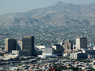
El Paso is a city in and the county seat of El Paso County, Texas, United States. The 2020 population of the city from the U.S. Census Bureau was 678,815, making it the 22nd-largest city in the U.S., the sixth-largest city in Texas, and the second-largest city in the Southwestern United States after Phoenix, Arizona. The city is also the second-largest majority-Hispanic city in the U.S., with 81% of its population being Hispanic, San Antonio being first. Its metropolitan statistical area covers all of El Paso and Hudspeth counties in Texas, and had a population of 868,859 in 2020. El Paso has consistently been ranked as one of the safest large cities in the United States.

<span class="mw-page-title-main">Homestead Meadows North, Texas</span> Census-designated place in Texas, United States

Homestead Meadows North is a census-designated place (CDP) in El Paso County, Texas, United States. The population was 5,124 at the 2010 census. It is part of the El Paso Metropolitan Statistical Area. The ZIP Code encompassing the CDP area is 79938.

<span class="mw-page-title-main">Socorro, Texas</span> City in Texas, United States

Socorro is a city in El Paso County, Texas, United States. It is located on the north bank of the Rio Grande southeast of El Paso, and on the border of Mexico. El Paso adjoins it on the west and the smaller city of San Elizario on the southeast; small unincorporated areas of El Paso County separate it from the nearby municipalities of Horizon City to the north and Clint to the east. As of the 2020 census, the city population was 34,306. By the 2010 census, the number had grown to 32,013. As of July 1, 2019, the population estimate for the city from the U.S. Census was 34,370. It is part of the El Paso Metropolitan Statistical Area. The city is El Paso County's second-largest municipality, after El Paso. It has a council-manager type of government with five city council members. Socorro is the 93rd-largest community in Texas.

<span class="mw-page-title-main">Sparks, Texas</span> Census-designated place in Texas, United States

Sparks is a census-designated place (CDP) in El Paso County, Texas, United States. The population was 4,529 at the 2010 census. It is part of the El Paso Metropolitan Statistical Area. The ZIP Code encompassing the CDP area is 79928.

<span class="mw-page-title-main">Tornillo, Texas</span> Census-designated place in Texas, United States

Tornillo is a census-designated place (CDP) and border town in El Paso County, Texas, United States. The population was 1,568 at the 2010 census. It is part of the El Paso Metropolitan Statistical Area. The Tornillo and Guadalupe, Chihuahua, area is connected by the Tornillo-Guadalupe Bridge.

<span class="mw-page-title-main">Presidio, Texas</span> City in Texas, United States

Presidio is a city in Presidio County, Texas, United States. It is situated on the Rio Grande River, on the opposite side of the U.S.–Mexico border from Ojinaga, Chihuahua. The name originates from Spanish and means "fortress". The population was 4,169 at the 2000 census, and had increased to 4,426 as of the 2010 US census.

<span class="mw-page-title-main">Ysleta, El Paso, Texas</span> Place in Texas, United States

Ysleta is a community in El Paso, Texas, United States. Ysleta was settled between October 9 and October 12, 1680, when Spanish conquistadors, Franciscan clerics and Tigua Indians took refuge along the southern bank of the Rio Grande. These people were fleeing the Pueblo Revolt in New Mexico. Ysleta is the oldest European settlement in the area that is the present-day U.S. state of Texas.

Mission Valley is an area of El Paso, Texas, United States, which includes part of Eastside and all Lower Valley districts. It is the third largest area of the city, behind East El Paso and Central El Paso. Hawkins Road and Interstate 10 border the Mission Valley. This location is considered the oldest area of El Paso, dating back to the late 17th century when present-day Texas was under the rule of Nueva España.

<span class="mw-page-title-main">Camino Real de Tierra Adentro</span> Northernmost of Mexico Citys four "royal roads"

The Camino Real de Tierra Adentro, also known as the Silver Route, was a Spanish 2,560-kilometre-long (1,590 mi) road between Mexico City and San Juan Pueblo, New Mexico, USA, that was used from 1598 to 1882. It was the northernmost of the four major "royal roads" that linked Mexico City to its major tributaries during and after the Spanish colonial era.

The San Elizario Salt War, also known as the Salinero Revolt or the El Paso Salt War, was an extended and complex range war of the mid-19th century that revolved around the ownership and control of immense salt lakes at the base of the Guadalupe Mountains in West Texas. What began in 1866 as a political and legal struggle among Anglo Texan politicians and capitalists gave rise in 1877 to an armed struggle by ethnic Mexican and Tejano inhabitants living on both sides of the Rio Grande near El Paso against a leading politician, who was supported by the Texas Rangers. The struggle reached its climax with the siege and surrender of 20 Texas Rangers to a popular army of perhaps 500 men in the town of San Elizario, Texas. The arrival of the African-American 9th Cavalry and a sheriff's posse of New Mexico mercenaries caused hundreds of Tejanos to flee to Mexico, some in permanent exile. The right of individuals to own the salt lakes, which had previously been held as a community asset, was established by force of arms.

Founded as El Paso del Norte by Spanish Franciscan friars at an important mountain pass, the area became a small agricultural producer though most settlement was south of the river where modern Mexico lies. The city was considered part of New Mexico under Spanish Conquerors and was tied economically to Santa Fe, New Mexico and the Chihuahuan mining districts of San Felipe El Real and San José del Parral.

<span class="mw-page-title-main">Ysleta Mission</span> United States historic place

The Ysleta Mission, located in the Ysleta del Sur Pueblo within the municipality of El Paso, Texas, is recognized as the oldest continuously operated parish in the State of Texas. The Ysleta community is also recognized as the oldest in Texas and claims to have the oldest continuously cultivated plot of land in the United States.

<span class="mw-page-title-main">Presidio Chapel of San Elizario</span> United States historic place

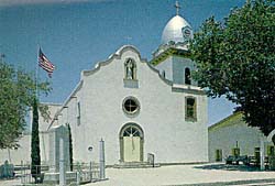
The Presidio Chapel of San Elizario was built in 1877 at the same place where an earlier Mexican chapel stood. The building is located in the central square of San Elizario, 17.5 miles south-southeast of El Paso. It was listed on the National Register of Historic Places in 1972. It is an example of the Spanish Colonial style.

References

  1. "2019 U.S. Gazetteer Files". United States Census Bureau. Retrieved August 7, 2020.
  2. 1 2 "Population and Housing Unit Estimates". United States Census Bureau. May 24, 2020. Retrieved May 27, 2020.
  3. 1 2 "U.S. Census website". United States Census Bureau . Retrieved 2008-01-31.
  4. "US Board on Geographic Names". United States Geological Survey. 2007-10-25. Retrieved 2008-01-31.
  5. 1 2 "Geographic Identifiers: 2010 Demographic Profile Data (G001): San Elizario CDP, Texas". U.S. Census Bureau, American Factfinder. Archived from the original on February 12, 2020. Retrieved January 11, 2013.
  6. 1 2 3 4 Torok, George D., From the Pass to the Pueblos, El Camino Real de Tierra Adentro National Historic Trail, Sunstone Press, Santa Fe, 2012
  7. DONELL, KOHOUT, MARTIN (15 June 2010). "SAN ELIZARIO, TX". www.tshaonline.org. Retrieved 7 September 2018.
  8. "Epcounty.com - History - Mission Trail". Archived from the original on 2010-10-22. Retrieved 2013-11-19.
  9. 1 2 "Maya Sanchez wins San Elizario mayoral bid - el Paso Times". Archived from the original on 2014-07-06. Retrieved 2018-11-28.
  10. "San Elizario is officially incorporated - el Paso Times". Archived from the original on 2013-11-19. Retrieved 2013-11-19.
  11. "2015 U.S. Gazetteer Files". United States Census Bureau . Retrieved 2016-07-13.
  12. "Census of Population and Housing". Census.gov. Retrieved June 4, 2016.
  13. "Explore Census Data". data.census.gov. Retrieved 2022-05-19.
  14. https://www.census.gov/ [ not specific enough to verify ]
  15. "About the Hispanic Population and its Origin". www.census.gov. Retrieved 18 May 2022.
  16. "San Elizario Historic District--Celebrate Hispanic Heritage Month 2005 -- National Register of Historic Places, NPS". Archived from the original on 2014-10-13.
  17. "Fandango" . Retrieved 7 September 2018 via www.imdb.com.
  1. Note: the US Census treats Hispanic/Latino as an ethnic category. This table excludes Latinos from the racial categories and assigns them to a separate category. Hispanics/Latinos can be of any race. [14] [15]