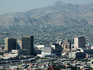
El Paso County is the westernmost county in the U.S. state of Texas. As of the 2020 census, the population was 865,657, making it the ninth-most populous county in the state of Texas. Its seat is the city of El Paso, the sixth-most populous city in Texas and the 22nd-most populous city in the United States. The county was created in 1850 and later organized in 1871.

Landmark is a census-designated place (CDP) in Pulaski County, Arkansas, United States. Per the 2020 census, the population was 3,585. It is part of the Little Rock–North Little Rock–Conway Metropolitan Statistical Area.
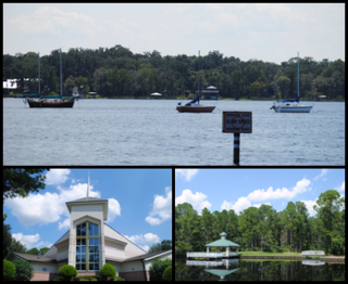
Fruit Cove is a census-designated place (CDP) in St. Johns County, Florida, United States. It is located in the community of St. Johns. The population was 32,143 at the 2020 census.

Chaparral is an unincorporated community and census-designated place (CDP) in Doña Ana and Otero counties, New Mexico. The population was 14,631 at the 2010 census. Chaparral is primarily a bedroom community for the neighboring city of El Paso, Texas, and the neighboring military installations of White Sands Missile Range and Fort Bliss. It is officially part of the Las Cruces Metropolitan Statistical Area.

Mesquite is an unincorporated community and census-designated place (CDP) in Doña Ana County, New Mexico, United States. The population was 1,112 at the 2010 census, up from 948 at the 2000 census. It is part of the Las Cruces Metropolitan Statistical Area.

Placitas is a census-designated place (CDP) in Sandoval County, New Mexico, United States. As of the 2010 census, its population was 4,977. It is part of the Albuquerque Metropolitan Statistical Area.

San Felipe Pueblo is a census-designated place (CDP) in Sandoval County, New Mexico, United States, and is located 10 miles (16 km) north of Bernalillo. As of the 2000 census, the CDP population was 2,080. It is part of the Albuquerque Metropolitan Statistical Area.

Circle D-KC Estates is a census-designated place (CDP) in Bastrop County, Texas, United States. The population was 2,588 at the 2020 census.
Wyldwood is a census-designated place (CDP) in Bastrop County, Texas, United States. The population was 3,694 at the 2020 census.
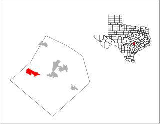
Agua Dulce is a census-designated place (CDP) in El Paso County, Texas, United States. The population was 3,218 at the 2020 census. It is part of the El Paso Metropolitan Statistical Area. The ZIP Code encompassing the CDP area is 79928.

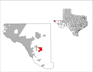
Homestead Meadows North is a census-designated place (CDP) in El Paso County, Texas, United States. The population was 5,124 at the 2010 census. It is part of the El Paso Metropolitan Statistical Area. The ZIP Code encompassing the CDP area is 79938.

Homestead Meadows South is a census-designated place (CDP) in El Paso County, Texas, United States. The population was 7,247 at the 2010 census. It is part of the El Paso Metropolitan Statistical Area. The ZIP Code encompassing the CDP area is 79938.
Prado Verde is a census-designated place (CDP) in El Paso County, Texas, United States. The population is 246 according to the 2010 census. It is part of the El Paso Metropolitan Statistical Area. The ZIP Code encompassing the CDP area is 79932.

Sparks is a census-designated place (CDP) in El Paso County, Texas, United States. The population was 4,529 at the 2010 census. It is part of the El Paso Metropolitan Statistical Area. The ZIP Code encompassing the CDP area is 79928.

Tornillo is a census-designated place (CDP) and border town in El Paso County, Texas, United States. The population was 1,568 at the 2010 census. It is part of the El Paso Metropolitan Statistical Area. The Tornillo and Guadalupe, Chihuahua, area is connected by the Tornillo–Guadalupe International Bridge.
Vinton is a village in El Paso County, Texas, United States. The population was 1,971 at the 2010 census. It is part of the El Paso Metropolitan Statistical Area.

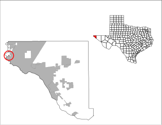
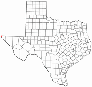
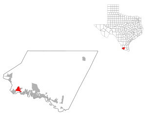
Westway is a census-designated place (CDP) in El Paso County, Texas, United States. The population was 4,188 at the 2010 census. It is part of the El Paso Metropolitan Statistical Area. It is located east of Interstate 10, approximately 2 miles (3 km) from the New Mexico - Texas state line. The ZIP Code encompassing the CDP area is 79835.

Villa Verde is a census-designated place (CDP) in Hidalgo County, Texas. The population was 874 at the 2010 United States Census. It is part of the McAllen–Edinburg–Mission Metropolitan Statistical Area.

Falcon Heights is a census-designated place (CDP) in Starr County, Texas, United States. The population was 18 at the 2020 census, down from 53 at the 2010 census.
Roma Creek is a former census-designated place (CDP) in Starr County, Texas, United States. The population was 350 at the 2010 census down from 610 at the 2000 census.


