Brewster County is a county located in the U.S. state of Texas. It is in West Texas and its county seat is Alpine. It is one of the nine counties that comprise the Trans-Pecos region, and borders Mexico. Brewster County is the largest county by area in the state - at 6,192 square miles (16,040 km2) it is over three times the size of the state of Delaware, and more than 500 square miles (1,300 km2) bigger than Connecticut.

Rocky Mountain National Park is an American national park located approximately 55 mi (89 km) northwest of Denver in north-central Colorado, within the Front Range of the Rocky Mountains. The park is situated between the towns of Estes Park to the east and Grand Lake to the west. The eastern and western slopes of the Continental Divide run directly through the center of the park with the headwaters of the Colorado River located in the park's northwestern region. The main features of the park include mountains, alpine lakes and a wide variety of wildlife within various climates and environments, from wooded forests to mountain tundra.

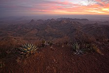
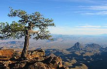
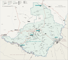
Big Bend National Park is an American national park located in West Texas, bordering Mexico. The park has national significance as the largest protected area of Chihuahuan Desert topography and ecology in the United States, and was named after a large bend in the Rio Grande/Río Bravo. The park protects more than 1,200 species of plants, more than 450 species of birds, 56 species of reptiles, and 75 species of mammals. Additional park activities include scenic drives, programs led by Big Bend park rangers, and stargazing.

The Chihuahuan Desert is a desert ecoregion designation covering parts of northern Mexico and the southwestern United States. It occupies much of far West Texas, the middle to lower Rio Grande Valley and the lower Pecos Valley in New Mexico, and a portion of southeastern Arizona, as well as the central and northern portions of the Mexican Plateau. It is bordered on the west by the Sonoran Desert, the Colorado Plateau, and the extensive Sierra Madre Occidental range, along with northwestern lowlands of the Sierra Madre Oriental range. Its largest, continual expanse is located in Mexico, covering a large portion of the state of Chihuahua, along with portions of Coahuila, north-eastern Durango, the extreme northern part of Zacatecas, and small western portions of Nuevo León. With an area of about 501,896 km2 (193,783 sq mi), it is the largest desert in North America. The desert is fairly young, existing for only 8000 years.

Guadalupe Mountains National Park is an American national park in the Guadalupe Mountains, east of El Paso, Texas. The mountain range includes Guadalupe Peak, the highest point in Texas at 8,751 feet (2,667 m), and El Capitan used as a landmark by travelers on the route later followed by the Butterfield Overland Mail stagecoach line. The ruins of a stagecoach station stand near the Pine Springs visitor center. The restored Frijole Ranch contains a small museum of local history and is the trailhead for Smith Spring. The park covers 86,367 acres in the same mountain range as Carlsbad Caverns National Park, about 25 miles (40 km) to the north in New Mexico. The Guadalupe Peak Trail winds through pinyon pine and Douglas-fir forests as it ascends over 3,000 feet (910 m) to the summit of Guadalupe Peak, with views of El Capitan and the Chihuahuan Desert.
The Sandia Mountains are a mountain range located in Bernalillo and Sandoval counties, immediately to the east of the city of Albuquerque in New Mexico in the southwestern United States. The mountains are just due south of the southern terminus of the Rocky Mountains, and are part of the Sandia–Manzano Mountains. This is largely within the Cibola National Forest and protected as the Sandia Mountain Wilderness. The highest point is Sandia Crest, 10,678 feet (3,255 m).

The Sierra Madre Oriental is a mountain range in northeastern Mexico. The Sierra Madre Oriental is part of the American Cordillera, a chain of mountain ranges (cordillera) that consists of an almost continuous sequence of mountain ranges that form the western "backbone" of North America, Central America, South America, and Antarctica.

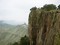
Emory Peak, located in Big Bend National Park, is the highest peak in the Chisos Mountains and the highest in Brewster County. The peak is named for William H. Emory, the chief surveyor of the U.S. Boundary Survey team of 1852. From the Chisos Basin the peak appears to be a minor ridge, while the summit of Casa Grande, one mile closer, seems to be much taller. From the west, Emory Peak is clearly visible as a point slightly higher than most of the mountain range.

Franklin Mountains State Park is a Texas state park in El Paso, Texas, that protects the Franklin Mountains. Park headquarters are located at an elevation of 5,426 feet (1,654 m) with the highest peak, North Franklin Mountain, reaching 7,192 feet (2,192 m). It is one of the largest urban parks in the nation lying completely within city limits, covering 24,247.56 acres (9,813 ha). Franklin Mountains State Park is open year-round for recreational hiking, mountain biking, picnicking and scenic driving and vistas.

Frozen Head State Park and Natural Area is a state park in Morgan County, Tennessee, in the southeastern United States. The park, situated in the Crab Orchard Mountains between the city of Wartburg and the community of Petros, contains some of the highest mountains in Tennessee west of the Blue Ridge.

Boquillas was a small settlement in Texas, located on the northern banks of the Rio Grande. It was located within Brewster County, 5 miles northeast of San Vicente, Texas. The place existed to service the mining operations at Boquillas del Carmen, Mexico, just across the Rio Grande.

The Sierra Madre Oriental pine–oak forests are a temperate broadleaf and mixed forest ecoregion of northeastern and Central Mexico, extending into the state of Texas in the United States.
Quercus tardifolia, the Chisos Mountains oak or lateleaf oak, is a rare North American species of oak. It has been found in the Chisos Mountains inside Big Bend National Park in Texas, and in the nearby Sierra del Carmen across the Río Grande in northern Coahuila.

Lajitas is an unincorporated community in Brewster County, Texas, United States, near the Big Bend National Park. According to the Handbook of Texas, the community had a population of 75 in 2010.

Big Bend Ranch State Park is a 311,000-acre (126,000 ha) state park located on the Rio Grande in Brewster and Presidio counties, Texas. It is the largest state park in Texas. The closest major town is Presidio, Texas. The state park's head office is located in Lajitas, Texas at the Barton Warnock Visitor Center. It includes Colorado Canyon.

Glenn Springs is an uninhabited place in the state of Texas, United States, which is of historical importance. The Glenn Springs area was a natural spring providing water for Apache and Kiowa routing the Grand Indian Crossing passage at Boquillas. The Comanche tribes beseech the fresh water crossing on the Comanche Trail during their equine incursions from and to the Mexican Plateau, Sierra Madre Oriental, and the Trans-Mexican Volcanic Belt regions of Mexico.

Echinocereus chisoensis is a rare North American species of cactus known by the common name Chisos Mountain hedgehog cactus, native to the Chihuahuan Desert of northern Mexico and the south-central United States.

The Sierra del Carmen, also called the Sierra Maderas del Carmen, is a northern finger of the Sierra Madre Oriental in the state of Coahuila, Mexico. The Sierra begins at the Rio Grande at Big Bend National Park and extends southeast for about 72 kilometres (45 mi), reaching a maximum elevation of 2,720 metres (8,920 ft). Part of the Sierra del Carmen is protected in the Maderas del Carmen Biosphere Reserve as part of a bi-national effort to conserve a large portion of the Chihuahua Desert in Mexico and Texas.
Quercus intricata, common name dwarf oak, intricate oak or Coahuila scrub oak, is a plant species native to northern Mexico and western Texas.

The Cañón de Santa Elena Flora and Fauna Protection Area is a protected area for plants and wildlife in the Mexican municipalities of Manuel Benavides and Ojinaga, in the state of Chihuahua. It was founded on November 7, 1994 and has an area of 277,209 hectares.