
Garza County is a county located in the U.S. state of Texas. As of the 2020 census, its population was 5,816, of which most of the population were residing in its county seat, and only incorporated municipality, Post. The county was created in 1876 and later organized in 1907. Garza is named for a pioneer Bexar County family, as it was once a part of that county.
Ransom Canyon is a town in Lubbock County of West Texas, United States. The population was 1,096 at the 2010 census. It is part of the Lubbock Metropolitan Statistical Area.
Roscoe is a city in Nolan County in the U.S. state of Texas near the intersection of Interstate 20 and US Highway 84. The Union Pacific Railroad passes through the center of the city.

The Llano Estacado, sometimes translated into English as the Staked Plains, is a region in the Southwestern United States that encompasses parts of eastern New Mexico and northwestern Texas. One of the largest mesas or tablelands on the North American continent, the elevation rises from 3,000 feet (900 m) in the southeast to over 5,000 feet (1,500 m) in the northwest, sloping almost uniformly at about 10 feet per mile (2 m/km).

West Texas is a loosely defined region in the U.S. state of Texas, generally encompassing the arid and semiarid lands west of a line drawn between the cities of Wichita Falls, Abilene, and Del Rio.

The Caprock Escarpment is a term used in West Texas and Eastern New Mexico to describe the geographical transition point between the level High Plains of the Llano Estacado and the surrounding rolling terrain.

Ira is an unincorporated community in Scurry County, Texas, United States. It lies in the southwestern corner of the county at the junction of State Highway 350 and Farm to Market Road 1606, 10 miles southwest of Snyder, and has an estimated population of 250.

Southland is an unincorporated community in Garza County, Texas, United States. It lies along the eastern edge of the Llano Estacado on U.S. Route 84, twenty miles northwest of Post.
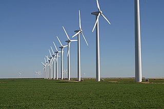
The Brazos Wind Farm, also known as the Green Mountain Energy Wind Farm at Brazos, is located in Borden and Scurry counties in Texas. It has 160 wind turbines, each rated at one megawatt (MW) and supplied by Mitsubishi, and was completed in December 2003. The wind farm sells generated power on a long-term basis to a local power distributor, TXU Energy, to supply approximately 30,000 homes in Texas. 50% of the Brazos Wind Farm is owned by Shell Wind Energy, Inc.

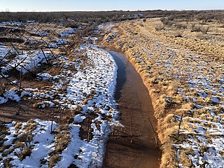
Blanco Canyon is a canyon located in the U.S. state of Texas. Eroded by the White River into the Caprock Escarpment on the east side of the Llano Estacado, the canyon runs for 34 miles (55 km) in a southeasterly direction, gradually widening from its beginning in southwestern Floyd County to 10 miles (16 km) across at its mouth in southeastern Crosby County. It also gradually deepens from 50 feet (15 m) at its beginning to 300 to 500 feet at its mouth. One side canyon, 5-mile long Crawfish Canyon, was cut by Crawfish Creek as it feeds into the White River from the west.

Fieldton is an unincorporated community in Lamb County, Texas, United States. Fieldton has a post office with the ZIP code 79326.

Grassland is an unincorporated community in Lynn County, West Texas, United States. According to the Handbook of Texas, the community had an estimated population of 61 in 2000.

The Double Mountain Fork Brazos River is an ephemeral, sandy-braided stream about 170 mi (280 km) long, heading on the Llano Estacado of West Texas about 11.5 mi (18.5 km) southeast of Tahoka, Texas, flowing east-northeast across the western Rolling Plains to join the Salt Fork, forming the Brazos River about 18 mi (29 km) west-northwest of Haskell, Texas.

Close City is an unincorporated community in western Garza County, approximately 6.5 mi (10.5 km) west-northwest of Post. The small rural community lies on the High Plains of the Llano Estacado in West Texas.
The Salt Fork Brazos River is a braided, highly intermittent stream about 150 mi (240 km) long, heading along the edge of the Llano Estacado about 26 mi (42 km) east-southeast of Lubbock, Texas. From its source, it flows generally east-southeastward to join the Double Mountain Fork to form the Brazos River about 18 mi (29 km) west-northwest of Haskell, Texas. The Salt Fork stretches across portions of Crosby, Garza, Kent, and Stonewall counties of West Texas.

Canyon Valley is a ghost town in southern Crosby County, Texas, United States. Today, only a few farms and ranches are scattered across the area.

Hobbs is an unincorporated community in west Fisher County, Texas, United States. It is located at the intersection of Farm to Market Roads 611 and 1614, about 20 mi (32 km) east of Snyder. It lies within the physiographic region known as the Rolling Plains in the valley of the Clear Fork Brazos River.

Wastella is a ghost town in northwestern Nolan County, Texas, United States. It is located at the intersection of U.S. Highway 84 and Farm to Market Road 1982, approximately 8 mi (13 km) northwest of Roscoe. It lies within the physiographic region known as the Rolling Plains, to the southeast of the high plains of the Llano Estacado.
McDonald Creek is an intermittent stream, about 25 mi (40 km) long, heading about 10 mi (16 km) south-southwest of Crosbyton, Texas, and trending generally southeast to join the Salt Fork Brazos River near the community of Verbena, Texas.

Roundup is an unincorporated community located in northeastern Hockley County, Texas, United States. The town is located on the high plains of the Llano Estacado at the intersection of U.S. Route 84 and Farm to Market Road 2130 between Anton and Shallowater.


