Garza County, Texas

Last updated

Garza County
County
Garza County Texas courthouse 2020.jpg
Garza County Courthouse in Post
Map of Texas highlighting Garza County.svg
Location within the U.S. state of Texas
Texas in United States.svg
Texas's location within the U.S.
Coordinates: 33°11′N101°18′W / 33.18°N 101.3°W / 33.18; -101.3
CountryFlag of the United States.svg United States
StateFlag of Texas.svg  Texas
Founded1907
Seat Post
Largest cityPost
Area
  Total896 sq mi (2,320 km2)
  Land893 sq mi (2,310 km2)
  Water2.8 sq mi (7 km2)  0.3%
Population
 (2020)
  Total5,816
  Density6.5/sq mi (2.5/km2)
Time zone UTC−6 (Central)
  Summer (DST) UTC−5 (CDT)
Congressional district 19th
Website www.garzacounty.net/index.html
Post Dispatch newspaper covers local events of Garza County. Post Dispatch newspaper, Post, TX IMG 4610.JPG
Post Dispatch newspaper covers local events of Garza County.
Wells Fargo Bank serves Garza County through its outlet in Post. Wells Fargo Bank, Post, TX IMG 4640.JPG
Wells Fargo Bank serves Garza County through its outlet in Post.

Garza County is a county located in the U.S. state of Texas. As of the 2020 census, its population was 5,816, of which most of the population were residing in its county seat, and only incorporated municipality, Post. [1] [2] The county was created in 1876 and later organized in 1907. [3] Garza is named for a pioneer Bexar County family, as it was once a part of that county.

Contents

History

Indigenous peoples of the Americas were the first inhabitants of the area, with evidence from around 2000 BC. Later inhabitants were the Kiowa and Comanche. [4]

In 1875, W. C. Young of Fort Worth and Irishman Ben Galbraith of Illinois established the beginnings of the Curry Comb Ranch in the northwestern part of Garza County. [5]

Garza County was formed in 1876 from Bexar County, and named for the prominent Bexar County family of José Antonio de la Garza. [6] [7]

By 1880, the county census count was 36 people. [4] The Square and Compass Ranch was started 2 years later by the Nave and McCord Cattle Company. They put up the first barbed-wire fence in 1884. [8] That same year, OS Ranch was founded by brothers Andrew J. and Frank M. Long of Lexington, Kentucky. [9] The county's population reached 185 persons by the last year of the 19th century. [4] Post was founded in 1907 as a utopian venture by, and named for, cereal king C.W. Post. [4] [10] From 1909 to 1913, C.W. Post built a cotton gin and a cotton mill, and attempted to improve agriculture production through rainmaking, involving the heavy use of explosives fired from kites and towers along the rim of the Caprock Escarpment. [4] [11]

In 1926, oil was discovered in the county. [4] [12] Quanah and Bryan Maxey discovered a 16-foot-long tusk of a prehistoric imperial mammoth in 1934. This tusk is currently located in the American Museum of Natural History, New York City. [4]

In 1957, a prehistoric Indian site was recorded at Cowhead Mesa by Emmet Shedd of Post. [13] In 1960–1965, South Plains Archaeological Society excavations of Cowhead Mesa found artifacts to date inhabitation back to 2000 BC. [13]

The most important businesses in the county by 1980 were agribusiness, oil and gas extraction, and textile mills. [4]

Geography

According to the U.S. Census Bureau, the county has a total area of 896 sq mi (2,320 km2), of which 893 sq mi (2,310 km2) are land and 2.8 sq mi (7.3 km2) (0.3%) are covered by water. [14] It is located southeast of Lubbock in the Canyonlands of the Llano Estacado Escarpment.

Major roads and highways

Adjacent counties

Demographics

Historical population
CensusPop.Note
1880 36
1890 14−61.1%
1900 1851,221.4%
1910 1,995978.4%
1920 4,253113.2%
1930 5,58631.3%
1940 5,6781.6%
1950 6,28110.6%
1960 6,6115.3%
1970 5,289−20.0%
1980 5,3360.9%
1990 5,143−3.6%
2000 4,872−5.3%
2010 6,46132.6%
2020 5,816−10.0%
U.S. Decennial Census [15]
1850–2010 [16] 2010 [17] 2020 [18]
Garza County, Texas - Demographic Profile
(NH = Non-Hispanic)
Race / EthnicityPop 2010 [17] Pop 2020 [18] % 2010% 2020
White alone (NH)2,9622,16245.84%37.17%
Black or African American alone (NH)3922306.07%3.95%
Native American or Alaska Native alone (NH)25280.39%0.48%
Asian alone (NH)8250.12%0.43%
Pacific Islander alone (NH)300.05%0.00%
Some Other Race alone (NH)1100.02%0.17%
Mixed Race/Multi-Racial (NH)24890.37%1.53%
Hispanic or Latino (any race)3,0463,27247.14%56.26%
Total6,4615,816100.00%100.00%

Note: the US Census treats Hispanic/Latino as an ethnic category. This table excludes Latinos from the racial categories and assigns them to a separate category. Hispanics/Latinos can be of any race.

As of the census [19] of 2000, 4,872 people, 1,663 households, and 1,217 families resided in the county. The population density was 5 people/sq mi (1.9 people/km2). The 1,928 housing units averaged 2 per square mile (0.77/km2). The racial makeup of the county was 56.7% White, 4.8 African American, 0.2% Native American, 0.1% Asian, 17.1% from other races, and 3.00% from two or more races. Hispanics or Latinos of any race were 37.2% of the population.

Of the 1,663 households, 36.0% had children under the age of 18 living with them, 58.5% were married couples living together, 11.2% had a female householder with no husband present, and 26.8% were not families. About 23.8% of all households were made up of individuals, and 12.0% had someone living alone who was 65 or older. The average household size was 2.65 and the average family size was 3.15.

In the county, the population was distributed as 28.00% under the age of 18, 7.90% from 18 to 24, 28.60% from 25 to 44, 21.30% from 45 to 64, and 14.10% who were 65 years of age or older. The median age was 35 years. For every 100 females, there were 112.30 males. For every 100 females age 18 and over, there were 111.30 males.

The median income for a household in the county was $27,206, and for a family was $31,173. Males had a median income of $26,604 versus $18,105 for females. The per capita income for the county was $12,704. About 17.50% of families and 22.30% of the population were below the poverty line, including 29.6% of those under age 18 and 18.6% of those age 65 or over.

Communities

City

Unincorporated communities

Politics

Republican Drew Springer, Jr., a businessman from Muenster in Cooke County, has since January 2013 represented Garza County in the Texas House of Representatives. [20]

United States presidential election results for Garza County, Texas [21]
Year Republican Democratic Third party
No.%No.%No.%
2020 1,41385.48%23113.97%90.54%
2016 1,22582.55%23015.50%291.95%
2012 1,26380.96%27917.88%181.15%
2008 1,35677.49%37521.43%191.09%
2004 1,48081.68%32617.99%60.33%
2000 1,30273.56%45425.65%140.79%
1996 94653.93%70340.08%1055.99%
1992 98252.01%55829.56%34818.43%
1988 1,18354.02%98945.16%180.82%
1984 1,21969.66%52129.77%100.57%
1980 1,18862.63%67735.69%321.69%
1976 75543.77%95755.48%130.75%
1972 1,15372.11%44627.89%00.00%
1968 61537.05%66239.88%38323.07%
1964 56731.03%1,25468.64%60.33%
1960 73746.76%82952.60%100.63%
1956 62844.38%78655.55%10.07%
1952 74248.15%79751.72%20.13%
1948 17615.86%86177.57%736.58%
1944 14412.42%84272.65%17314.93%
1940 19815.49%1,07383.96%70.55%
1936 13214.01%80785.67%30.32%
1932 879.62%81289.82%50.55%
1928 79473.59%28526.41%00.00%
1924 33135.06%58862.29%252.65%
1920 285.92%39282.88%5311.21%
1916 143.91%33092.18%143.91%
1912 74.27%14487.80%137.93%

Education

School districts serving the county include: [22]

The county is in the service area of South Plains College. [23]

See also

Related Research Articles

<span class="mw-page-title-main">Yoakum County, Texas</span> County in Texas, United States

Yoakum County is a county located in the far western portion of the U.S. state of Texas. As of the 2020 census, the population was 7,694. Its county seat is Plains. The county was created in 1876 and later organized in 1907. It is named for Henderson King Yoakum, a Texas historian.

<span class="mw-page-title-main">Wilson County, Texas</span> County in Texas, United States

Wilson County is a county located in the U.S. state of Texas. As of the 2020 census, its population was 49,753. Its county seat is Floresville. The county is named after James Charles Wilson. Wilson County is part of the San Antonio–New Braunfels, Texas, metropolitan statistical area.

<span class="mw-page-title-main">Terry County, Texas</span> County in Texas, United States

Terry County is a county located in the U.S. state of Texas. As of the 2020 census, its population was 11,831. Its county seat is Brownfield. The county was demarked in 1876 and organized in 1904. It is named for Benjamin Franklin Terry, a colonel in the Confederate Army. Terry County was one of 46 dry counties in the state of Texas, but is now a moist county. Terry County is one of the most productive pumpkin producing counties in the United States.

<span class="mw-page-title-main">Taylor County, Texas</span> County in Texas, United States

Taylor County is a county located in the U.S. state of Texas. As of the 2020 census, its population was 143,208. Its county seat is Abilene. The county was created in 1858 and later organized in 1878. It is named for Edward Taylor, George Taylor, and James Taylor, three brothers who died at the Battle of the Alamo.

<span class="mw-page-title-main">Swisher County, Texas</span> County in Texas, United States

Swisher County is a county in the U.S. state of Texas. As of the 2020 census, its population was 6,971. Its county seat is Tulia. The county was created in 1876 and later organized in 1890. It is named for James G. Swisher, a soldier of the Texas Revolution and signer of the Texas Declaration of Independence.

<span class="mw-page-title-main">Sutton County, Texas</span> County in Texas, United States

Sutton County is a county located on the Edwards Plateau in the U.S. state of Texas. As of the 2020 census, the population was 3,372. Its county seat is Sonora. The county was created in 1887 and organized in 1890. Sutton County is named for John S. Sutton, an officer in the Confederate Army.

<span class="mw-page-title-main">Medina County, Texas</span> County in Texas, United States

Medina County is a county located in the U.S. state of Texas. As of the 2020 census, its population was 50,748. Its county seat is Hondo. The county is named for the Medina River. The extreme northern part of the county lies within the Edwards Plateau, which elevates into the Texas Hill Country. The Medina Dam, the fourth largest in the nation when completed in 1913, is listed on the National Register of Historic Places. The irrigation project, creating Medina Lake, was built by 1500 skilled workers who worked in shifts operating 24 hours a day to complete the dam in two years. Medina County is part of the San Antonio, TX Metropolitan Statistical Area.

<span class="mw-page-title-main">Lynn County, Texas</span> County in Texas, United States

Lynn County is a county in the U.S. state of Texas. As of the 2020 census, its population was 5,596. Its county seat is Tahoka. The county was created in 1876 and organized in 1903.

<span class="mw-page-title-main">Lamb County, Texas</span> County in Texas, United States

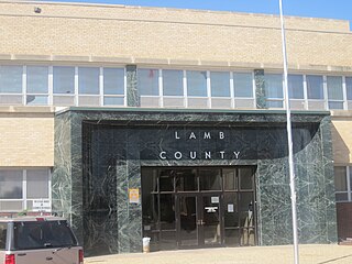
Lamb County is a county located in the U.S. state of Texas. As of the 2020 census, its population was 13,045. Its county seat is Littlefield. The county was created in 1876, but not organized until 1908. It is named for George A. Lamb, who died in the Battle of San Jacinto.

<span class="mw-page-title-main">Kent County, Texas</span> County in Texas, United States

Kent County is a county located in the U.S. state of Texas. As of the 2020 census, its population was 753, making it the sixth-least populous county in Texas. Its county seat is Jayton. The county was created in 1876 and later organized in 1892. It is named for Andrew Kent, who died at the Battle of the Alamo. Kent County is a prohibition or entirely dry county, one of four remaining in the state.

<span class="mw-page-title-main">Hockley County, Texas</span> County in Texas, United States

Hockley County is a county located in the U.S. state of Texas. As of the 2020 census, its population was 21,537. Its county seat is Levelland. The county was created in 1876, but not organized until 1921. It is named for George Washington Hockley, a secretary of war of the Republic of Texas.

<span class="mw-page-title-main">Hansford County, Texas</span> County in Texas, United States

Hansford County is a county located in the U.S. state of Texas. As of the 2020 census, its population was 5,285. Its county seat is Spearman. The county was created in 1876 and organized in 1889. It is named for John M. Hansford, a Texas state congressman and judge.

<span class="mw-page-title-main">Hale County, Texas</span> County in Texas, United States

Hale County is a county located in the U.S. state of Texas. As of the 2020 census, its population was 32,522. Its county seat is Plainview. The county was created in 1876 and organized in 1888. It is named for Lt. John C. Hale, a hero of the Battle of San Jacinto. Hale County comprises the Plainview, Texas micropolitan statistical area.

<span class="mw-page-title-main">Guadalupe County, Texas</span> County in Texas, United States

Guadalupe County is a county located in the U.S. state of Texas. As of the 2020 census, its population was 172,706. The county seat is Seguin. The county was founded in 1846 and is named after Guadalupe River.

<span class="mw-page-title-main">Crosby County, Texas</span> County in Texas, United States

Crosby County is a county located in the U.S. state of Texas. As of the 2020 census, its population was 5,133. The county seat is Crosbyton. The county was founded in 1876 and later organized in 1886. Both the county and its seat are named for Stephen Crosby, a land commissioner in Texas.

<span class="mw-page-title-main">Crockett County, Texas</span> County in Texas, United States

Crockett County is a county located on the Edwards Plateau in the U.S. state of Texas. As of the 2020 census, its population was 3,098. The county seat is Ozona. The county was founded in 1875 and later organized in 1891. It is named in honor of Davy Crockett, the legendary frontiersman who died at the Battle of the Alamo.

<span class="mw-page-title-main">Comal County, Texas</span> County in Texas, United States

Comal County is a county located on the Edwards Plateau in the U.S. state of Texas. As of the 2020 census, its population was 161,501. Comal County is known for its rich German-Texan and European history. Its county seat is New Braunfels.

<span class="mw-page-title-main">Bandera County, Texas</span> County in Texas, United States

Bandera County is a county in the U.S. state of Texas. It is located in the Hill Country and its county seat is Bandera. Bandera county was settled be German and Polish emigrants in the mid 1800s. Many residents are descendants of those same emigrants.

<span class="mw-page-title-main">Post, Texas</span> City in Texas, United States of America

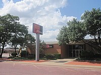
Post is a city in and the county seat of Garza County, Texas, United States. Its population was 5,376 at the 2010 census.

Von Ormy is a city in southwest Bexar County, Texas, United States. As of the 2020 census, it had a population of 1,174. It is part of the San Antonio metropolitan statistical area.

References

  1. "Census of Population and Housing, 2000 [United States]: County-to-County Worker Flow Files". ICPSR Data Holdings. October 1, 2003. doi:10.3886/icpsr13405 . Retrieved June 3, 2022.
  2. "Find a County". National Association of Counties. Archived from the original on May 31, 2011. Retrieved June 7, 2011.
  3. "Texas: Individual County Chronologies". Texas Atlas of Historical County Boundaries. The Newberry Library. 2008. Retrieved May 23, 2015.
  4. 1 2 3 4 5 6 7 8 Leffler, John (June 15, 2010). "Garza County, Texas". Handbook of Texas Online. Texas State Historical Association. Retrieved December 17, 2010.
  5. Holden, William Curry (June 12, 2010). "Curry Comb Ranch". Handbook of Texas Online. Texas State Historical Association. Retrieved December 17, 2010.
  6. Orozco, Cynthia E (June 15, 2010). "José Antonio de la Garza". Handbook of Texas Online. Texas State Historical Association. Retrieved December 17, 2010.
  7. Gannett, Henry (1905). The Origin of Certain Place Names in the United States. Govt. Print. Off. p. 135.
  8. Holden, William Curry (June 15, 2010). "Square and Compass Ranch". Handbook of Texas Online. Texas State Historical Association. Retrieved December 17, 2010.
  9. Woolley, Bryan (2004). "Pack Rat". Texas Road Trip. Texas Christian University Press. pp. 25–36. ISBN   978-0-87565-291-7.
  10. "Post, Texas". Texas Escapes. Texas Escapes - Blueprints For Travel, LLC. Retrieved December 17, 2010.
  11. Pearce, William M (June 15, 2010). "Charles William Post". Handbook of Texas Online. Texas State Historical Association. Retrieved December 17, 2010.
  12. "Alumni Notes". The Alcalde: 52. September–October 1985.
  13. 1 2 Howard, Margaret Ann (June 12, 2010). "Cowhead Mesa". Handbook of Texas Online. Texas State Historical Association. Retrieved December 17, 2010.
  14. "2010 Census Gazetteer Files". United States Census Bureau. August 22, 2012. Retrieved April 27, 2015.
  15. "Decennial Census of Population and Housing by Decade". US Census Bureau.
  16. "Texas Almanac: Population History of Counties from 1850–2010" (PDF). Texas Almanac. Archived (PDF) from the original on October 9, 2022. Retrieved April 27, 2015.
  17. 1 2 "P2 HISPANIC OR LATINO, AND NOT HISPANIC OR LATINO BY RACE - 2010: DEC Redistricting Data (PL 94-171) - Garza County, Texas". United States Census Bureau .
  18. 1 2 "P2 HISPANIC OR LATINO, AND NOT HISPANIC OR LATINO BY RACE - 2020: DEC Redistricting Data (PL 94-171) - Garza County, Texas". United States Census Bureau .
  19. "U.S. Census website". United States Census Bureau . Retrieved May 14, 2011.
  20. "State Rep. Springer announces district tour July 30". Lubbock Avalanche-Journal, July 16, 2013. Retrieved July 18, 2013.
  21. Leip, David. "Dave Leip's Atlas of U.S. Presidential Elections". uselectionatlas.org. Retrieved July 24, 2018.
  22. "2020 CENSUS - SCHOOL DISTRICT REFERENCE MAP: Garza County, TX" (PDF). U.S. Census Bureau. Archived (PDF) from the original on October 9, 2022. Retrieved June 29, 2022. - list
  23. Texas Education Code, Sec. 130.198. SOUTH PLAINS COLLEGE DISTRICT SERVICE AREA.

33°11′N101°18′W / 33.18°N 101.30°W / 33.18; -101.30