Comanche County | |
---|---|
Coordinates: 31°57′N98°34′W / 31.95°N 98.56°W | |
Country | United States |
State | Texas |
Founded | 1856 |
Named for | Comanche tribe |
Seat | Comanche |
Largest city | Comanche |
Area | |
• Total | 948 sq mi (2,460 km2) |
• Land | 938 sq mi (2,430 km2) |
• Water | 9.9 sq mi (26 km2) 1.0% |
Population (2020) | |
• Total | 13,594 |
• Density | 14/sq mi (5.5/km2) |
Time zone | UTC−6 (Central) |
• Summer (DST) | UTC−5 (CDT) |
Congressional district | 25th |
Comanche County is a county located on the Edwards Plateau in Central Texas. As of the 2020 census, its population was 13,594. [1] [2] The county seat is Comanche. [3] The county was founded in 1856 and is named for the Comanche Native American tribe.
Among the first inhabitants of present-day Comanche County were the Comanche Indian tribe. [4]
In 1854, Jesse M. Mercer and others organized a colony near the future settlement of Newburg. [5] in Comanche County on lands earlier granted by Mexico to Stephen F. Austin and Samuel May Williams. [6] Frank M. Collier built the first log house in the county. [7]
In 1856, the Texas legislature formed Comanche County from Coryell and Bosque counties. Cora community, named after Cora Beeman of Bell County, was designated as the county seat. [8] Comanche became the county seat in 1859. [9] As of 1860, the county population was 709 persons, including 61 slaves. [4]
The Comanche Chief [10] began publication in 1873. Editor Joe Hill's brother, Robert T. Hill, worked on the newspaper while developing his esteemed career as a geologist. [11]
In 1874, John Wesley Hardin and his gang celebrated his 21st birthday in Brown and Comanche counties. Deputy Charles Webb drew his gun, provoking a gunfight that ended Webb's life. A lynch mob was formed, but Hardin and his family were put into protective custody. The mob broke into the jail and hanged his brother Joe and two cousins. Hardin fled. [12] He was arrested in 1877 by Texas Rangers and a local authority on a train in Pensacola, Florida, while traveling under the alias James W. Swain. [13] He was tried in Comanche for the murder of Deputy Sheriff Charles Webb, and sentenced to 25 years in Huntsville Prison. [14]
Known for its fertile soil, Comanche County was a hotbed of political populism in the latter years of the 19th century. [15]
In 1886, "one of those too horribly frequent crimes was committed by an African American. He was quickly caught and was punished in accordance with the rules of the unwritten law." Following this lynching, at a meeting of the white citizens "it was resolved to give every african American in the county one week's notice to leave the county, and committees of men from different sections of the county were appointed to carry out the will of the white people." [16] [17]
Notices have been posted in various towns of Comanche County, Texas, warning all "niggers" to leave under penalty of death, and it is fairly declared by the whites that no colored people will be allowed to live in that section. [18]
In my days over the public well in the little railroad station [of De Leon, Texas], 16 miles from Comanche, there was a villainously painted sign, which read as follows: "Niggers! Let not the sun set on you in Comanche County." [16]
Comanche County was a sundown town, the only such county in the U.S. to formally take this action. According to a 1953 study, the county took pride in and publicized its all-white population. [17]
Black porters on the train would hide in the baggage car as trains passed through Comanche County. Because of the threats to its porters, the railroad asked that the sign be removed, and the town of De Leon moved it to the town well, "in the middle of Texas Avenue". No report gives the date of the sign's removal. [19]
The Texas Central Railroad [20] began service in Comanche County in 1885 and began carrying cattle and cotton to market. [4] By 1890, cotton had become king in the county, but by the start of the 20th century, the boll weevil had devastated the county cotton industry for three decades. In 1907, farmers in the county began to experiment with peanut farming. [4]
Oil was discovered at Desdemona in 1910. [21] [22] The peak year for the Comanche County oil boom was 1920. [4]
In 1951–1952, a desperate, drought-stricken county experimented with rain making. [4] Proctor Lake was impounded in 1963 to provide flood control and drinking water. [23]
From 1968 to 1974, Comanche County native Jim Reese served as the mayor of Odessa, Texas. He launched unsuccessful congressional campaigns in the 1976 general election against the Democrat George H. Mahon and in the 1978 Republican primary against George W. Bush. During the 1970s, the oil industrialist Bill Noël of Odessa purchased orchards in Comanche County. [24]
As of 1982, Comanche produced more than 45,546,000 pounds (20,659,000 kg) of peanuts, ranking second in Texas. [4]
According to the U.S. Census Bureau, the county has a total area of 948 square miles (2,460 km2), of which 9.9 square miles (26 km2) (1.0%) are covered by water. [25] The county is located some 60 miles north of the geographic center of Texas.
The county is home to Proctor Lake.
Census | Pop. | Note | %± |
---|---|---|---|
1860 | 709 | — | |
1870 | 1,001 | 41.2% | |
1880 | 8,608 | 759.9% | |
1890 | 15,608 | 81.3% | |
1900 | 23,009 | 47.4% | |
1910 | 27,186 | 18.2% | |
1920 | 25,748 | −5.3% | |
1930 | 18,430 | −28.4% | |
1940 | 19,245 | 4.4% | |
1950 | 15,516 | −19.4% | |
1960 | 11,865 | −23.5% | |
1970 | 11,898 | 0.3% | |
1980 | 12,617 | 6.0% | |
1990 | 13,381 | 6.1% | |
2000 | 14,026 | 4.8% | |
2010 | 13,974 | −0.4% | |
2020 | 13,594 | −2.7% | |
U.S. Decennial Census [26] 1850–2010 [27] 2010 [28] 2020 [29] |
Race / Ethnicity | Pop 2010 [28] | Pop 2020 [29] | % 2010 | % 2020 |
---|---|---|---|---|
White alone (NH) | 10,145 | 9,197 | 72.60% | 67.65% |
Black or African American alone (NH) | 25 | 39 | 0.18% | 0.29% |
Native American or Alaska Native alone (NH) | 47 | 49 | 0.34% | 0.36% |
Asian alone (NH) | 34 | 38 | 0.24% | 0.28% |
Pacific Islander alone (NH) | 4 | 3 | 0.03% | 0.02% |
Some other race alone (NH) | 8 | 24 | 0.06% | 0.18% |
Mixed race/multiracial (NH) | 106 | 377 | 0.76% | 2.77% |
Hispanic or Latino (any race) | 3,605 | 3,867 | 25.80% | 28.45% |
Total | 13,974 | 13,594 | 100.00% | 100.00% |
Note: the US Census treats Hispanic/Latino as an ethnic category. This table excludes Latinos from the racial categories and assigns them to a separate category. Hispanics/Latinos can be of any race.
As of the census [30] of 2000, 14,026 people, 5,522 households, and 3,926 families were residing in the county. The population density was 15 people per square mile (5.8 people/km2). The 7,105 housing units had an average density of 8 per square mile (3.1/km2). The racial makeup of the county was 87.30% White, 0.44% African American, 0.61% Native American, 0.13% Asian, 9.71% from other races, and 1.82% from two or more races. About 21% of the population were Hispanics or Latinos of any race.
Of the 5,522 households, 29.8% had children under 18 living with them, 59.2% were married couples living together, 8.1% had a female householder with no husband present, and 28.9% were not families. About 26% of all households were made up of individuals, and 15.2% had someone living alone who was 65 or older. The average household size was 2.48, and the average family size was 2.98.
In the county, the age distribution was 25.3% under 18, 7.1% from 18 to 24, 23.3% from 25 to 44, 24.0% from 45 to 64, and 20.3% who were 65 or older. The median age was 40 years. For every 100 females, there were 95.8 males. For every 100 females 18 and over, there were 94.4 males.
The median income for a household in the county was $28,422, and for a family was $34,810. Males had a median income of $26,094 versus $18,912 for females. The per capita income for the county was $14,677. About 14% of families and 17.30% of the population were below the poverty line, including 22.6% of those under 18 and 16.0% of those 65 or over.
The Comanche County-City Airport is located 2.0 nautical miles (2.3 mi; 3.7 km) northeast of the City of Comanche's central business district. [31]
Comanche County is currently listed as part of the Dallas-Fort Worth DMA. Local media outlets include KDFW-TV, KXAS-TV, WFAA-TV, KTVT-TV, KERA-TV, KTXA-TV, KDFI-TV, KDAF-TV, and KFWD-TV. Other nearby stations that provide coverage for Comanche County include KCEN-TV, KWTX-TV, and KAKW-DT from the Waco/Temple/Killeen DMA, and KTXS-TV, KTAB-TV, and KRBC-TV from the Abilene/Sweetwater/Brownwood DMA.
Two local newspapers serve Comanche County: the Comanche Chief and the De Leon Free Press.
Year | Republican | Democratic | Third party | |||
---|---|---|---|---|---|---|
No. | % | No. | % | No. | % | |
2020 | 5,177 | 85.06% | 853 | 14.02% | 56 | 0.92% |
2016 | 4,333 | 82.74% | 789 | 15.07% | 115 | 2.20% |
2012 | 3,944 | 80.39% | 890 | 18.14% | 72 | 1.47% |
2008 | 3,813 | 73.09% | 1,334 | 25.57% | 70 | 1.34% |
2004 | 3,813 | 72.38% | 1,431 | 27.16% | 24 | 0.46% |
2000 | 3,334 | 66.39% | 1,636 | 32.58% | 52 | 1.04% |
1996 | 2,123 | 44.42% | 2,138 | 44.74% | 518 | 10.84% |
1992 | 1,666 | 31.75% | 2,296 | 43.75% | 1,286 | 24.50% |
1988 | 2,120 | 44.53% | 2,622 | 55.07% | 19 | 0.40% |
1984 | 2,678 | 54.12% | 2,248 | 45.43% | 22 | 0.44% |
1980 | 1,977 | 43.09% | 2,550 | 55.58% | 61 | 1.33% |
1976 | 1,297 | 27.41% | 3,414 | 72.16% | 20 | 0.42% |
1972 | 2,608 | 68.31% | 1,176 | 30.80% | 34 | 0.89% |
1968 | 1,436 | 34.81% | 1,980 | 48.00% | 709 | 17.19% |
1964 | 962 | 25.19% | 2,851 | 74.65% | 6 | 0.16% |
1960 | 1,828 | 47.73% | 1,979 | 51.67% | 23 | 0.60% |
1956 | 1,900 | 48.99% | 1,962 | 50.59% | 16 | 0.41% |
1952 | 2,411 | 52.46% | 2,181 | 47.45% | 4 | 0.09% |
1948 | 408 | 11.64% | 2,915 | 83.17% | 182 | 5.19% |
1944 | 356 | 9.40% | 2,941 | 77.66% | 490 | 12.94% |
1940 | 610 | 15.90% | 3,226 | 84.08% | 1 | 0.03% |
1936 | 355 | 11.81% | 2,587 | 86.09% | 63 | 2.10% |
1932 | 192 | 5.75% | 3,134 | 93.86% | 13 | 0.39% |
1928 | 1,483 | 53.08% | 1,311 | 46.92% | 0 | 0.00% |
1924 | 456 | 53.90% | 276 | 32.62% | 114 | 13.48% |
1920 | 930 | 32.52% | 1,633 | 57.10% | 297 | 10.38% |
1916 | 148 | 7.57% | 1,494 | 76.38% | 314 | 16.05% |
1912 | 68 | 3.52% | 1,659 | 85.83% | 206 | 10.66% |
Young County is a county located in the U.S. state of Texas. As of the 2020 census, its population was 17,867. Its county seat is Graham. The county was created in 1856 and organized in 1874. It is named for William Cocke Young, an early Texas settler and soldier.
Reagan County is a county on the Edwards Plateau in the U.S. state of Texas. As of the 2020 census, its population was 3,385. The county seat is Big Lake. The county is named after John Henninger Reagan (1818–1905), who was the postmaster general of the Confederate States and also a U.S. senator, U.S. representative, and first chairman of the Railroad Commission of Texas.
Mason County is a rural county located on the Edwards Plateau in the U.S. state of Texas. At the 2020 census, its population was 3,953. Its county seat is Mason. The county is named for Fort Mason, which was located in the county.
Llano County is a county located on the Edwards Plateau in the U.S. state of Texas. As of the 2020 census, its population was 21,243. Its county seat is Llano, and the county is named for the Llano River.
Limestone County is a county in the U.S. state of Texas. As of the 2020 census, its population was 22,146. Its county seat is Groesbeck. The county was created in 1846.
Hardin County is a county located in the U.S. state of Texas, United States. As of the 2020 census, its population was 56,231. The county seat is Kountze. The county is named for the family of William Hardin from Liberty County, Texas.
Hansford County is a county located in the U.S. state of Texas. As of the 2020 census, its population was 5,285. Its county seat is Spearman. The county was created in 1876 and organized in 1889. It is named for John M. Hansford, a Texas state congressman and judge.
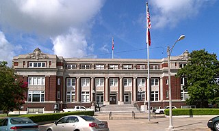
Hamilton County is a county located on the Edwards Plateau in the U.S. state of Texas. As of the 2020 census, its population was 8,222. The county seat is Hamilton. The county was created in 1858. It is named for James Hamilton Jr., a former governor of South Carolina who gave financial aid to the Republic of Texas.
Crosby County is a county located in the U.S. state of Texas. As of the 2020 census, its population was 5,133. The county seat is Crosbyton. The county was founded in 1876 and later organized in 1886. Both the county and its seat are named for Stephen Crosby, a land commissioner in Texas.
Concho County is a county located on the Edwards Plateau in the U.S. state of Texas. At the 2020 census, the population was 3,303. Its county seat is Paint Rock. The county was founded in 1858 and later organized in 1879. It is named for the Concho River.
Coleman County is a county located in the U.S. state of Texas. As of the 2020 census, its population was 7,684. The county seat is Coleman. The county was founded in 1858 and organized in 1864. It is named for Robert M. Coleman, a signer of the Texas Declaration of Independence and soldier at the Battle of San Jacinto.
Cherokee County is a county located in the U.S. state of Texas. As of the 2020 census, its population was 50,412. The county seat is Rusk, which lies 130 miles southeast of Dallas and 160 miles north of Houston. The county was named for the Cherokee, who lived in the area before being expelled in 1839. Cherokee County comprises the Jacksonville micropolitan statistical area, which is also included in the Tyler–Jacksonville combined statistical area.
Calhoun County is a county located in the U.S. state of Texas. As of the 2020 census, the population was 20,106. Its county seat is Port Lavaca. The county is named for John Caldwell Calhoun, the seventh vice president of the United States. Calhoun County comprises the Port Lavaca, TX Micropolitan Statistical Area, which is also included in the Victoria-Port Lavaca, TX Combined Statistical Area.
Caldwell County is a county located in the U.S. state of Texas. As of the 2020 census, its population was 45,883. Its county seat is Lockhart. The county was founded in 1848 and named after Mathew Caldwell, a ranger captain who fought in the Battle of Plum Creek against the Comanches and against Santa Anna's armies during the Texas Revolution. Caldwell was also a signer of the Texas Declaration of Independence.
Brown County is a county in west-central Texas. As of the 2020 census, the population was 38,095. Its county seat is Brownwood. The county was founded in 1856 and organized in 1858. It is named for Henry Stevenson Brown, a commander at the Battle of Velasco, an early conflict between Texians and Mexicans.
Blanco County is a United States county located in the U.S. state of Texas. It is located in Central Texas and its county seat is Johnson City.
Comanche is a city located in Comanche County in the U.S. state of Texas. The population was 4,335 at the 2010 census. It is the county seat of Comanche County.
De Leon is a city located in Comanche County in the U.S. state of Texas. Its population was 2,246 in the 2020 census. It is commonly associated with being named after the Spanish explorer Ponce de León, but the town is actually named for its location on the Leon River, which flows directly north and east of the community, and drains into nearby Proctor Lake.
Gustine is a town located in Comanche County in Central Texas, United States. The population was 476 at the 2010 census. The town, formerly known as Cora, was the county seat in the 1850s.
Runnels County is a county located in the U.S. state of Texas. As of the 2020 census, its population was 9,900. Its county seat is Ballinger. The county was created in 1858 and later organized in 1880. It is named for Hiram G. Runnels, a Texas state legislator.