Parts of this article (those related to demographics) need to be updated.(March 2019) |
Howard County | |
---|---|
Coordinates: 32°19′N101°26′W / 32.31°N 101.44°W | |
Country | United States |
State | Texas |
Founded | 1882 |
Named for | Volney E. Howard |
Seat | Big Spring |
Largest city | Big Spring |
Area | |
• Total | 904 sq mi (2,340 km2) |
• Land | 901 sq mi (2,330 km2) |
• Water | 3 sq mi (8 km2) 0.4% |
Population (2020) | |
• Total | 34,860 |
• Density | 39/sq mi (15/km2) |
Time zone | UTC−6 (Central) |
• Summer (DST) | UTC−5 (CDT) |
Congressional district | 19th |
Website | www |
Howard County is a county located in the U.S. state of Texas. At the 2020 census, its population was 34,860. [1] Its county seat is Big Spring. [2] The county was created in 1876 and organized in 1882. [3] It is named for Volney E. Howard, a U.S. Congressman from Texas. [4]
Howard County is included in the Big Spring, Texas micropolitan statistical area.
According to the U.S. Census Bureau, the county has a total area of 904 square miles (2,340 km2), of which 901 square miles (2,330 km2) are land and 3.4 square miles (8.8 km2) (0.4%) are covered by water. [5]
Howard County is located at the boundary between the Llano Estacado to the north and the Edwards Plateau to the south. Beals Creek, a tributary of the Colorado River, flows through the center of Big Spring and divides these two major physiographic regions.
Census | Pop. | Note | %± |
---|---|---|---|
1880 | 50 | — | |
1890 | 1,210 | 2,320.0% | |
1900 | 2,528 | 108.9% | |
1910 | 8,881 | 251.3% | |
1920 | 6,962 | −21.6% | |
1930 | 22,888 | 228.8% | |
1940 | 20,990 | −8.3% | |
1950 | 26,722 | 27.3% | |
1960 | 40,139 | 50.2% | |
1970 | 37,796 | −5.8% | |
1980 | 33,142 | −12.3% | |
1990 | 32,343 | −2.4% | |
2000 | 33,627 | 4.0% | |
2010 | 35,012 | 4.1% | |
2020 | 34,860 | −0.4% | |
U.S. Decennial Census [6] 1850–2010 [7] 2010 [8] 2020 [9] |
Race / Ethnicity | Pop 2010 [8] | Pop 2020 [9] | % 2010 | % 2020 |
---|---|---|---|---|
White alone (NH) | 18,801 | 15,672 | 53.70% | 44.96% |
Black or African American alone (NH) | 2,079 | 1,520 | 5.94% | 4.36% |
Native American or Alaska Native alone (NH) | 220 | 211 | 0.63% | 0.61% |
Asian alone (NH) | 256 | 386 | 0.73% | 1.11% |
Pacific Islander alone (NH) | 13 | 12 | 0.04% | 0.03% |
Some Other Race alone (NH) | 76 | 68 | 0.22% | 0.20% |
Mixed Race/Multi-Racial (NH) | 312 | 817 | 0.89% | 2.34% |
Hispanic or Latino (any race) | 13,255 | 16,174 | 37.86% | 46.40% |
Total | 35,012 | 34,860 | 100.00% | 100.00% |
Note: the US Census treats Hispanic/Latino as an ethnic category. This table excludes Latinos from the racial categories and assigns them to a separate category. Hispanics/Latinos can be of any race.
As the 2000 census, [10] there were 33,627 people, 11,389 households and 7,949 families residing in the county. The population density was 37 people per square mile (14 people/km2). There were 13,589 housing units at an average density of 15 units per square mile (5.8/km2). The racial makeup of the county was 80.14% White, 4.13% Black or African American, 0.59% Native American, 0.59% Asian, 0.01% Pacific Islander, 12.43% from other races, and 2.10% from two or more races. 37.46% of the population were Hispanic or Latino of any race.
There were 11,389 households, of which 32.80% had children under the age of 18 living with them, 53.30% were married couples living together, 12.20% had a female householder with no husband present, and 30.20% were non-families. 26.80% of all households were made up of individuals, and 13.20% had someone living alone who was 65 years of age or older. The average household size was 2.53 and the average family size was 3.07.
24.20% of the population were under the age of 18, 9.00% from 18 to 24, 30.90% from 25 to 44, 21.30% from 45 to 64, and 14.60% who were 65 years of age or older. The median age was 36 years. For every 100 females there were 118.00 males. For every 100 females age 18 and over, there were 122.50 males.
The median household income was $30,805 and the median family income was $37,262. Males had a median income of $28,971 and females $21,390. The per capita income was $15,027. About 14.50% of families and 18.60% of the population were below the poverty line, including 24.70% of those under age 18 and 15.50% of those age 65 or over.
According to the United States Census Bureau Howard County, Texas has an estimated population of 36,459 as of July 1, 2018. That's a 4.1% increase from the 2010 census. 21.7% of the people are under 18 years old and 12.9% are older than 65 years old. Of the current population, 42.8% are female. In regards to race, 87.8% are white, 7.3% are black and 42.4% are Hispanic. The owner occupied housing rate is at 68.1%, with the median value of owner occupied housing being $85,700. High School graduates make up 82.1% of the population while only 12.9% have a Bachelor's degree or higher. [11]
The county is served by a daily newspaper, local radio stations KBST (AM), KBST-FM, KBTS (FM), KBYG (AM), nearby stations KBXJ (FM), KPET (AM) and KWDC (FM), and the various Midland and Odessa radio and TV stations.
From 1912 through 1964, Howard County voters, in common with the Solid South, voted predominantly for the Democratic candidate in presidential elections. Since 1980, the trend has swung to voting chiefly for the Republican candidate.
Year | Republican | Democratic | Third party | |||
---|---|---|---|---|---|---|
No. | % | No. | % | No. | % | |
2020 | 8,054 | 78.64% | 2,069 | 20.20% | 118 | 1.15% |
2016 | 6,637 | 76.09% | 1,770 | 20.29% | 316 | 3.62% |
2012 | 6,453 | 74.22% | 2,110 | 24.27% | 132 | 1.52% |
2008 | 7,029 | 72.55% | 2,545 | 26.27% | 115 | 1.19% |
2004 | 7,480 | 73.33% | 2,663 | 26.11% | 58 | 0.57% |
2000 | 6,668 | 69.84% | 2,744 | 28.74% | 136 | 1.42% |
1996 | 5,007 | 50.80% | 3,732 | 37.86% | 1,118 | 11.34% |
1992 | 5,129 | 47.17% | 3,735 | 34.35% | 2,009 | 18.48% |
1988 | 6,024 | 57.28% | 4,445 | 42.26% | 48 | 0.46% |
1984 | 7,519 | 64.31% | 4,115 | 35.20% | 57 | 0.49% |
1980 | 6,658 | 58.86% | 4,451 | 39.35% | 203 | 1.79% |
1976 | 4,899 | 40.92% | 6,984 | 58.34% | 89 | 0.74% |
1972 | 7,343 | 72.85% | 2,714 | 26.92% | 23 | 0.23% |
1968 | 3,812 | 36.30% | 3,897 | 37.11% | 2,792 | 26.59% |
1964 | 3,272 | 34.93% | 6,083 | 64.94% | 12 | 0.13% |
1960 | 3,403 | 40.83% | 4,844 | 58.12% | 88 | 1.06% |
1956 | 3,051 | 40.30% | 4,506 | 59.52% | 14 | 0.18% |
1952 | 3,412 | 41.60% | 4,779 | 58.27% | 11 | 0.13% |
1948 | 561 | 11.10% | 4,179 | 82.72% | 312 | 6.18% |
1944 | 334 | 7.71% | 3,588 | 82.79% | 412 | 9.51% |
1940 | 367 | 7.80% | 4,329 | 92.05% | 7 | 0.15% |
1936 | 230 | 6.90% | 3,094 | 92.86% | 8 | 0.24% |
1932 | 149 | 5.15% | 2,733 | 94.40% | 13 | 0.45% |
1928 | 812 | 54.86% | 665 | 44.93% | 3 | 0.20% |
1924 | 186 | 12.85% | 1,100 | 76.02% | 161 | 11.13% |
1920 | 107 | 11.80% | 703 | 77.51% | 97 | 10.69% |
1916 | 30 | 3.42% | 747 | 85.18% | 100 | 11.40% |
1912 | 22 | 3.14% | 530 | 75.61% | 149 | 21.26% |
Terry County is a county located in the U.S. state of Texas. As of the 2020 census, its population was 11,831. Its county seat is Brownfield. The county was demarked in 1876 and organized in 1904. It is named for Benjamin Franklin Terry, a colonel in the Confederate Army. Terry County was one of 46 dry counties in the state of Texas, but is now a moist county. Terry County is one of the most productive pumpkin producing counties in the United States.
Morris County is a county located near the eastern border of the U.S. state of Texas. As of the 2020 census, its population was 11,973. Its county seat is Daingerfield. Morris County is probably named for William Wright Morris, an early judge and planter from Henderson, also in northeast Texas. As of 2016, Morris County is no longer one of six entirely dry, prohibition counties in the state of Texas. Morris County is "partially wet."
Mitchell County is a county in the U.S. state of Texas. As of the 2020 census, its population was 8,990. Its county seat is Colorado City. The county was created in 1876 and organized in 1881. It is named for Asa and Eli Mitchell, two early settlers and soldiers in the Texas Revolution.
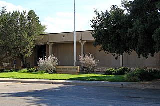
Martin County is a county in the U.S. state of Texas. As of the 2020 census, its population was 5,237. Its county seat is Stanton. The county was created in 1876 and organized in 1884. It is named for Wylie Martin, an early settler.
Hopkins County is a county located in the U.S. state of Texas. As of the 2020 census, its population was 36,787. Its county seat is Sulphur Springs. Hopkins County is named for the family of David Hopkins, an early settler in the area. Hopkins County comprises the Sulphur Springs, TX Micropolitan Statistical Area. Hopkins County was once known as the Dairy Capital of Texas. Although dairy farms declined in the area in the late 1990s there are still a number of these located there. The Southwest Dairy Museum is located in Sulphur Springs.
Hockley County is a county located in the U.S. state of Texas. As of the 2020 census, its population was 21,537. Its county seat is Levelland. The county was created in 1876, but not organized until 1921. It is named for George Washington Hockley, a secretary of war of the Republic of Texas.
Frio County is a county located in the U.S. state of Texas. As of the 2020 census, its population was 18,385. The county seat is Pearsall. The county was created in 1858 and later organized in 1871. Frio is named for the Frio River, whose name is Spanish for "cold".
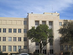
Ector County is a county located in the U.S. state of Texas. In the 2020 census, its population was 165,171. Its county seat is Odessa. The county was founded in 1887 and organized in 1891. It is named for Matthew Ector, a Confederate general in the American Civil War.
Dawson County is a county in the U.S. state of Texas. As of the 2020 census, its population was 12,456. The county seat is Lamesa. The county was created in 1876 and later organized in 1905. It is named for Nicholas Mosby Dawson, a soldier of the Texas Revolution. Dawson County comprises the Lamesa, TX Micropolitan Statistical Area (μSA), and it is, by population, the smallest Micropolitan Statistical Area in the United States.
Collingsworth County is a county in the U.S. state of Texas. As of the 2020 census, its population was 2,652. Its county seat is Wellington. The county was created in 1876 and later organized in 1890. It is named for James Collinsworth, a signer of the Texas Declaration of Independence and first chief justice of the Republic of Texas. Collingsworth County was one of 30 prohibition, or entirely dry, counties in Texas, but a vote in 2017 changed this law.
Childress County is a county located in the U.S. state of Texas. As of the 2020 census, its population was 6,664. The county seat is Childress. The county was created in 1876 and later organized in 1887. It is named for George Campbell Childress, the author of the Texas Declaration of Independence.
Briscoe County is a county located in the U.S. state of Texas. As of the 2020 census, the population was 1,435. Its county seat is Silverton. The county was created in 1876 and later organized in 1892. It is named for Andrew Briscoe, a soldier during the Texas Revolution.
Fanning Springs is a city in Gilchrist and Levy counties in the U.S. state of Florida. It is part of the Gainesville metropolitan area. The population was 1,182 at the 2020 census.
Zolfo Springs is a town in Hardee County, Florida, United States. It is part of the Florida Heartland region. The population was 1,737 at the 2020 census.
Chester is a city in Howard County, Iowa, United States. The population was 139 in the 2020 census, a decrease of 7.9% from the 151 population in the 2000 census. Chester is located close to the state line from Minnesota.
Howard is a city in and the county seat of Elk County, Kansas, United States. As of the 2020 census, the population of the city was 570.
Industry is a town in Austin County, Texas, United States, at the junction of State Highway 159 (SH 159) and Farm to Market Road 109 (FM 109). The population was 268 at the 2020 census. Industry was the first permanent German settlement in Texas. Friedrich Ernst, Industry's founder, settled here in 1831 and gained Industry the title "Cradle of German Settlement in Texas".
Stanton is a city in and the county seat of Martin County, Texas, United States. Stanton was founded as Marienfeld by German immigrants that were some of the first settlers in this region of Texas. The population was 2,657 at the 2020 census.
Stratford is a town and county seat of Sherman County, Texas, United States. The population was 2,017 at the 2010 census, up from 1,991 in 2000.
Josephine is a city in Collin and Hunt counties in the U.S. state of Texas. Its population was 812 at the 2010 census, with 755 residents in Collin County and 57 in Hunt County. By 2020, its population increased to 2,119.