Menard County, Texas

Last updated

Menard County
Menard county courthouse 2010.jpg
The Menard County Courthouse in Menard
Map of Texas highlighting Menard County.svg
Location within the U.S. state of Texas
Texas in United States.svg
Texas's location within the U.S.
Coordinates: 30°54′N99°49′W / 30.9°N 99.82°W / 30.9; -99.82
CountryFlag of the United States.svg United States
StateFlag of Texas.svg  Texas
Founded1871
Named for Michel Branamour Menard
Seat Menard
Largest cityMenard
Area
  Total902 sq mi (2,340 km2)
  Land902 sq mi (2,340 km2)
  Water0.2 sq mi (0.5 km2)  0.03%
Population
 (2020)
  Total1,962
  Density2.2/sq mi (0.84/km2)
Time zone UTC−6 (Central)
  Summer (DST) UTC−5 (CDT)
Congressional district 11th
Website co.menard.tx.us
Historic Pioneer Rest Cemetery in Menard has graves dating to the 19th century. Pioneer Rest Cemetery, Menard, TX IMG 4366.JPG
Historic Pioneer Rest Cemetery in Menard has graves dating to the 19th century.

Menard County is a county located on the Edwards Plateau in the U.S. state of Texas. As of the 2020 census, its population was 1,962. [1] The county seat is Menard. [2] The county was created in 1858 and later organized in 1871. [3] It is named for Michel Branamour Menard, the founder of Galveston, Texas. [4]

Contents

History

Around 8000, early Native American inhabitants arrived. Later Native Americans included Comanche and Lipan Apache. [5] In 1757, Father Alonso Giraldo de Terreros founded Presidio San Luis de las Amarillas, as a support for Santa Cruz de San Sabá Mission, for the Apache Indians. [6] In the 1830s, James Bowie and Rezin P. Bowie, scoured the San Saba valley seeking a silver mine that the Spanish had believed to be in the area. They are unsuccessful, but the legend of the Lost Bowie Mine, also known as the Lost San Saba Mine or the Los Almagres Mine, fed the imagination of treasure-seekers for the next 150 years. [7] [8]

Camp San Saba was established in 1852 to protect settlers from Indian attacks. [9] [10] The state legislature formed Menard County from Bexar County in 1858. The county was named for Michel Branamour Menard, the founder of Galveston. Menardville, later known as Menard, became the county seat. [11]

By 1870, the county population was 667: 295 were white, and 372 were black, possibly due to the Buffalo Soldiers at Fort McKavett. [5] [9] The next year, county residents elected their own officials. [5] The county had an immigrant influx from Mexico. [5] In 1911, the Fort Worth and Rio Grande Railroad Company arrived. [5] Gas deposits were tapped in 1929, but plugged for lack of a market. [5] The local Parent-Teacher Association offered free lunches for needy children in 1931. [5]

In 1934, the Texas Relief Cannery was in operation. The Drought Relief Program bought cattle and sheep from area ranchers. [5] [12] A gas well was redrilled in 1941, and produced about seven million cubic feet of gas. [5] In 1946, a small oilfield was discovered northeast of Fort McKavett, but was abandoned the following year. [5] By the 1960s, oil and gas production had an average annual yield more than 270,000 barrels (43,000 m3). [5] In the 1980s, of the county's 40 oilfields, about 20 were still active, producing 132,000 to 185,000 barrels (29,400 m3) annually. [5]

Geography

According to the U.S. Census Bureau, the county has a total area of 902 square miles (2,340 km2), of which 902 square miles (2,340 km2) are land and 0.2 square miles (0.52 km2) (0.03%) is covered by water. [13]

Major highways

Adjacent counties

Demographics

Historical population
CensusPop.Note
1870 667
1880 1,23985.8%
1890 1,215−1.9%
1900 2,01165.5%
1910 2,70734.6%
1920 3,16216.8%
1930 4,44740.6%
1940 4,5211.7%
1950 4,175−7.7%
1960 2,964−29.0%
1970 2,646−10.7%
1980 2,346−11.3%
1990 2,252−4.0%
2000 2,3604.8%
2010 2,242−5.0%
2020 1,962−12.5%
U.S. Decennial Census [14]
1850–2010 [15] 2010 [16] 2020 [17]
Menard County, Texas - Demographic Profile
(NH = Non-Hispanic)
Race / EthnicityPop 2010 [16] Pop 2020 [17] % 2010% 2020
White alone (NH)1,4251,23163.56%62.74%
Black or African American alone (NH)11120.49%0.61%
Native American or Alaska Native alone (NH)670.27%0.36%
Asian alone (NH)350.13%0.25%
Pacific Islander alone (NH)030.00%0.15%
Some Other Race alone (NH)180.04%0.41%
Mixed Race/Multi-Racial (NH)6340.27%1.73%
Hispanic or Latino (any race)79066235.24%33.74%
Total2,2421,962100.00%100.00%

Note: the US Census treats Hispanic/Latino as an ethnic category. This table excludes Latinos from the racial categories and assigns them to a separate category. Hispanics/Latinos can be of any race.

As of the census [18] of 2000, 2,360 people, 990 households, and 665 families resided in the county. The population density was 3 people per square mile (1.2 people/km2). The 1,607 housing units averaged 2 units per square mile (0.77/km2). The racial makeup of the county was 87.54% White, 0.51% African American, 0.64% Native American, 0.34% Asian, 0.04% Pacific Islander, 9.79% from other races, and 1.14% from two or more races. About 31.69% of the population was Hispanic or Latino of any race.

Of the 990 households, 28.50% had children under the age of 18 living with them, 54.00% were married couples living together, 8.80% had a female householder with no husband present, and 32.80% were not families. Around 30.40% of all households was made up of individuals, and 17.50% had someone living alone who was 65 years of age or older. The average household size was 2.34 and the average family size was 2.91.

In the county, the population was distributed as 24.20% under the age of 18, 5.30% from 18 to 24, 21.90% from 25 to 44, 26.60% from 45 to 64, and 21.90% who were 65 years of age or older. The median age was 44 years. For every 100 females, there were 99.70 males. For every 100 females age 18 and over, there were 93.10 males.

The median income for a household in the county was $24,762, and for a family was $30,872. Males had a median income of $21,953 versus $20,000 for females. The per capita income for the county was $15,987. About 20.00% of families and 25.80% of the population were below the poverty line, including 39.90% of those under age 18 and 19.10% of those age 65 or over.

Communities

Census-designated place

Unincorporated communities

Ghost towns

Politics

United States presidential election results for Menard County, Texas [19]
Year Republican Democratic Third party
No.%No.%No.%
2020 82380.06%19719.16%80.78%
2016 68278.94%15417.82%283.24%
2012 66578.33%17120.14%131.53%
2008 71269.94%29528.98%111.08%
2004 76168.99%33130.01%111.00%
2000 64264.85%33433.74%141.41%
1996 44342.47%49046.98%11010.55%
1992 35427.72%55343.30%37028.97%
1988 55247.14%61452.43%50.43%
1984 72564.44%39435.02%60.53%
1980 54852.19%48946.57%131.24%
1976 44144.10%54354.30%161.60%
1972 64469.92%27329.64%40.43%
1968 49150.57%36237.28%11812.15%
1964 39740.30%58859.70%00.00%
1960 60855.32%49144.68%00.00%
1956 61465.88%31834.12%00.00%
1952 84367.87%39932.13%00.00%
1948 28328.41%66366.57%505.02%
1944 968.56%77669.16%25022.28%
1940 24617.57%1,15382.36%10.07%
1936 11513.48%73486.05%40.47%
1932 15014.25%90185.57%20.19%
1928 58971.57%23428.43%00.00%
1924 24742.73%30452.60%274.67%
1920 20347.65%19746.24%266.10%
1916 4412.83%26777.84%329.33%
1912 157.50%10954.50%7638.00%

The 1968 movie Journey to Shiloh features a group known as the "Concho County Comanches," and mentions Menard County.

See also

Related Research Articles

<span class="mw-page-title-main">Wythe County, Virginia</span> County in Virginia, United States

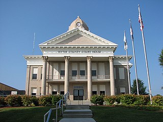
Wythe County is a county located in the southwestern part of the U.S. state of Virginia. As of the 2020 census, the population was 28,290. Its county seat is Wytheville.

<span class="mw-page-title-main">Tom Green County, Texas</span> County in Texas, United States

Tom Green County is a county located on the Edwards Plateau in the U.S. state of Texas. As of the 2020 census, its population was 120,003. Its county seat is San Angelo. The county was created in 1874 and organized the following year. It is named for Thomas Green, who was a Confederate soldier and lawyer. Tom Green County is included in the San Angelo metropolitan statistical area; the county is home to Goodfellow Air Force Base, as well as Angelo State University, part of the Texas Tech University System.

<span class="mw-page-title-main">Sutton County, Texas</span> County in Texas, United States

Sutton County is a county located on the Edwards Plateau in the U.S. state of Texas. As of the 2020 census, the population was 3,372. Its county seat is Sonora. The county was created in 1887 and organized in 1890. Sutton County is named for John S. Sutton, an officer in the Confederate Army.

<span class="mw-page-title-main">San Saba County, Texas</span> County in Texas, United States

San Saba County is a county located on the Edwards Plateau in western Central Texas, United States. As of the 2020 census, its population was 5,730. Its county seat is San Saba. The county is named after the San Saba River, which flows through the county.

<span class="mw-page-title-main">Montague County, Texas</span> County in Texas, United States

Montague County is a county located in the U.S. state of Texas, established in 1857. As of the 2020 census, its population was 19,965. The county seat is Montague. The county was created in 1857 and organized the next year. It is named for Daniel Montague, a surveyor and soldier in the Mexican–American War.

<span class="mw-page-title-main">Midland County, Texas</span> County in Texas, United States

Midland County is a county located in the U.S. state of Texas. As of 2020, the population was 169,983. The county seat is Midland. The county is so named for being halfway (midway) between Fort Worth and El Paso on the Texas and Pacific Railway. Midland County is included in the Midland, TX Metropolitan Statistical Area as well as the Midland–Odessa Combined Statistical Area.

<span class="mw-page-title-main">McCulloch County, Texas</span> County in Texas, United States

McCulloch County is a county located on the Edwards Plateau in the U.S. state of Texas. At the 2020 census, its population was 7,630. Its county seat is Brady. The county was created in 1856 and later organized in 1876. It is named for Benjamin McCulloch, a famous Texas Ranger and Confederate general.

<span class="mw-page-title-main">Mason County, Texas</span> County in Texas, United States

Mason County is a rural county located on the Edwards Plateau in the U.S. state of Texas. At the 2020 census, its population was 3,953. Its county seat is Mason. The county is named for Fort Mason, which was located in the county.

<span class="mw-page-title-main">Live Oak County, Texas</span> County in Texas, United States

Live Oak County is a county in the U.S. state of Texas. It was named for its native groves of live oak. George West is its county seat. Its population was 11,335 in the 2020 census.

<span class="mw-page-title-main">Howard County, Texas</span> County in Texas, United States

Howard County is a county located in the U.S. state of Texas. At the 2020 census, its population was 34,860. Its county seat is Big Spring. The county was created in 1876 and organized in 1882. It is named for Volney E. Howard, a U.S. Congressman from Texas.

<span class="mw-page-title-main">Hall County, Texas</span> County in Texas, United States

Hall County is a county located in the U.S. state of Texas. As of the 2020 census, the population is 2,825. Its county seat is Memphis. The county was created in 1876 and later organized in 1890. It is named for Warren D. C. Hall, a secretary of war for the Republic of Texas.

<span class="mw-page-title-main">Dickens County, Texas</span> County in Texas, United States

Dickens County is a county located in the U.S. state of Texas. As of the 2020 census, its population was 1,770. Its county seat is Dickens. The county was created in 1876 and later organized in 1891. Both the county and its seat are named for J. Dickens, who died at the Battle of the Alamo.

<span class="mw-page-title-main">Cooke County, Texas</span> County in Texas, United States

Cooke County is a county in the U.S. state of Texas. At the 2020 census, its population was 41,668. The county seat is Gainesville. The county was founded in 1848 and organized the next year. It is named for William Gordon Cooke, a soldier during the Texas Revolution. It is a part of the Texoma region.

<span class="mw-page-title-main">Concho County, Texas</span> County in Texas, United States

Concho County is a county located on the Edwards Plateau in the U.S. state of Texas. At the 2020 census, the population was 3,303. Its county seat is Paint Rock. The county was founded in 1858 and later organized in 1879. It is named for the Concho River.

<span class="mw-page-title-main">Brown County, Texas</span> County in Texas, United States

Brown County is a county in west-central Texas. As of the 2020 census, the population was 38,095. Its county seat is Brownwood. The county was founded in 1856 and organized in 1858. It is named for Henry Stevenson Brown, a commander at the Battle of Velasco, an early conflict between Texians and Mexicans.

<span class="mw-page-title-main">Paint Rock, Texas</span> Town in Texas, United States

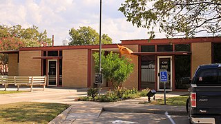
Paint Rock is a town in and the county seat of Concho County, Texas, United States. The population was 237 at the 2020 census.

<span class="mw-page-title-main">Menard, Texas</span> City in Texas, United States

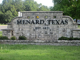
Menard is a city in and the county seat of Menard County, Texas, United States. Its population was 1,348 at the 2020 census.

<span class="mw-page-title-main">Fort Stockton, Texas</span> City in Texas, United States

Fort Stockton is a city in and the county seat of Pecos County, Texas, United States. It is located on Interstate 10, future Interstate 14, U.S. Highways 67, 285, and 385, and the Santa Fe Railroad, 329 mi (529 km) northwest of San Antonio and 240 mi (390 km) southeast of El Paso. Its population was 8,466 at the 2020 census.

<span class="mw-page-title-main">San Saba, Texas</span> City in Texas, United States

San Saba is a city located in, and the county seat of, San Saba County, Texas, United States. It was settled in 1854 and named for its location on the San Saba River. Its population was 3,099 at the 2010 census.

<span class="mw-page-title-main">Sterling City, Texas</span> City in Texas, United States

Sterling City is the county seat of Sterling County, Texas, United States. Its population was 1,121 at the 2020 census.

References

  1. "Menard County, Texas". United States Census Bureau . Retrieved February 23, 2021.
  2. "Find a County". National Association of Counties. Retrieved June 7, 2011.
  3. "Texas: Individual County Chronologies". Texas Atlas of Historical County Boundaries. The Newberry Library. 2008. Retrieved May 25, 2015.
  4. Gannett, Henry (1905). The Origin of Certain Place Names in the United States. U.S. Government Printing Office. p.  205.
  5. 1 2 3 4 5 6 7 8 9 10 11 12 Smyrl, Vivian Elizabeth. "Menard County, Texas". Handbook of Texas Online. Texas State Historical Association. Retrieved November 30, 2010.
  6. Robinson III, Charles M (2003). The Plains Wars 1757-1900. Routledge. pp. 11–13. ISBN   978-0-415-96912-3.
  7. Graves, John; Wyman Meinzer (2002). Texas Rivers. University of Texas Press. p. 79. ISBN   978-0-292-70198-4.
  8. "The Lost San Saba Mines". Tex Files. Archived from the original on April 21, 2012. Retrieved November 30, 2010.
  9. 1 2 "Fort McKavett". Texas Escapes. Texas Escapes - Blueprints For Travel, LLC. Retrieved November 30, 2010.
  10. Parent, Laurence (1997). Official Guide to Texas State Parks . University of Texas Press. pp.  71–72. ISBN   978-0-292-76575-7.
  11. "Menard, Texas". Texas Escapes. Texas Escapes - Blueprints For Travel, LLC. Retrieved November 30, 2010.
  12. "Texas Vernon's Texas Civil Statutes - Article 2372e. Buildings For Canneries For Unemployment Relief". Texas Vernon. Archived from the original on March 12, 2012. Retrieved November 30, 2010.
  13. "2010 Census Gazetteer Files". United States Census Bureau. August 22, 2012. Retrieved May 4, 2015.
  14. "Decennial Census of Population and Housing by Decade". US Census Bureau.
  15. "Texas Almanac: Population History of Counties from 1850–2010" (PDF). Texas Almanac. Archived (PDF) from the original on October 9, 2022. Retrieved May 4, 2015.
  16. 1 2 "P2 HISPANIC OR LATINO, AND NOT HISPANIC OR LATINO BY RACE - 2010: DEC Redistricting Data (PL 94-171) - Menard County, Texas". United States Census Bureau .
  17. 1 2 "P2 HISPANIC OR LATINO, AND NOT HISPANIC OR LATINO BY RACE - 2020: DEC Redistricting Data (PL 94-171) - Menard County, Texas". United States Census Bureau .
  18. "U.S. Census website". United States Census Bureau . Retrieved May 14, 2011.
  19. Leip, David. "Dave Leip's Atlas of U.S. Presidential Elections". uselectionatlas.org. Retrieved July 27, 2018.

30°54′N99°49′W / 30.90°N 99.82°W / 30.90; -99.82