Taylor County, Texas

Last updated

Taylor County
Taylor County Texas Courthouse 2015.jpg
New Taylor County Courthouse in Abilene
Map of Texas highlighting Taylor County.svg
Location within the U.S. state of Texas
Texas in United States.svg
Texas's location within the U.S.
Coordinates: 32°19′N99°53′W / 32.31°N 99.88°W / 32.31; -99.88
CountryFlag of the United States.svg United States
StateFlag of Texas.svg  Texas
Founded1878
Named for Edward, George, and James Taylor
Seat Abilene
Largest cityAbilene
Area
  Total919.3 sq mi (2,381 km2)
  Land915.6 sq mi (2,371 km2)
  Water3.8 sq mi (10 km2)  0.4%
Population
 (2020)
  Total143,208 Increase2.svg
  Density160/sq mi (60/km2)
Time zone UTC−6 (Central)
  Summer (DST) UTC−5 (CDT)
Congressional district 19th
Website www.taylorcountytexas.org
The Old Taylor County Courthouse has limited use. 1915 Taylor County Courthouse in 2015.jpg
The Old Taylor County Courthouse has limited use.

Taylor County is a county located in the U.S. state of Texas. As of the 2020 census, its population was 143,208. [1] [2] Its county seat is Abilene. [3] The county was created in 1858 and later organized in 1878. [4] It is named for Edward Taylor, George Taylor, and James Taylor, three brothers who died at the Battle of the Alamo.

Contents

Taylor County is included in the Abilene, TX metropolitan statistical area, and is considered part of West Texas.

History

Among first inhabitants of the area were the Penteka. [5] In 1849, Capt. Randolph Marcy, a U. S. Army engineer, passed through, scouting out West Texas-to-California routes. [6] The Texas legislature established Taylor County in 1858 from Bexar and Travis Counties. The county is named for Alamo defenders Edward, James, and George Taylor. The Butterfield Overland Mail established the Mountain Pass Station at Merkel; it was in continual use until 1861. [5]

By 1872, the first cattlemen had ventured into present Taylor County. [5] Six years later, Taylor County was organized. Buffalo Gap was named county seat. [5] [7] In 1880, the Texas & Pacific Railroad signed an agreement to run tracks through the future city of Abilene. [6] Abilene was established in 1882, and named after Abilene, Kansas. [8] Abilene became the county seat in 1883. [8] A wagon train of 10 Baptist families arrived in the county that year. [5]

The Abilene Board of Trade was organized in 1890, when 587 farms and ranches were in the county. [5] The next year, Hardin-Simmons University was established as Abilene Baptist College by the Sweetwater Baptist Association. [9] Lytle Lake was created in 1897. [5]

The State Epileptic Colony opened in Abilene in 1904. [10] In 1906, Abilene Christian University opened its doors as Childers Classical Institute. [11] In the 1920s, Hendricks Medical Center opened in Abilene as West Texas Baptist Sanitarium (1924) and the West Texas Historical Association was chartered in Abilene. [5] The first senior class of McMurry University graduated (1926). [12] Oil was discovered in the county a few years later (1929). [13]

In 1933, Abilene donated land for use by the Civilian Conservation Corps. [14]

Dyess Air Force Base was established as Abilene AFB in 1942; it is named in honor of Texas native and Bataan Death March survivor Lieutenant Colonel William Dyess. [15] The Abilene Philharmonic Orchestra was created, with Jay Dietzer as the first conductor, in 1950. [5] The Buffalo Gap Historic Village opened in 1956. [16]


Geography

According to the U.S. Census Bureau, the county has a total area of 919 sq mi (2,380 km2), of which 916 sq mi (2,370 km2) are land and 3.8 sq mi (9.8 km2) (0.4%) are covered by water. [17]

Major highways

Adjacent counties

Demographics

Historical population
CensusPop.Note
1880 1,736
1890 6,957300.7%
1900 10,49950.9%
1910 26,293150.4%
1920 24,081−8.4%
1930 41,02370.4%
1940 44,1477.6%
1950 63,37043.5%
1960 101,07859.5%
1970 97,853−3.2%
1980 110,93213.4%
1990 119,6557.9%
2000 126,5555.8%
2010 131,5063.9%
2020 143,2088.9%
U.S. Decennial Census [18]
1850–2010 [19] 2010 [20] 2020 [21]
Taylor County, Texas - Demographic Profile
(NH = Non-Hispanic)
Race / EthnicityPop 2010 [20] Pop 2020 [21] % 2010% 2020
White alone (NH)88,12187,31667.01%60.97%
Black or African American alone (NH)9,12210,9806.94%7.67%
Native American or Alaska Native alone (NH)5325890.40%0.41%
Asian alone (NH)1,9782,8151.50%1.97%
Pacific Islander alone (NH)1051610.08%0.11%
Some Other Race alone (NH)1334680.10%0.33%
Mixed Race/Multi-Racial (NH)2,4416,1231.86%4.28%
Hispanic or Latino (any race)29,07434,75622.11%24.27%
Total

Note: the US Census treats Hispanic/Latino as an ethnic category. This table excludes Latinos from the racial categories and assigns them to a separate category. Hispanics/Latinos can be of any race.

As of the census [22] of 2000, 126,555 people, 47,274 households, and 32,524 families resided in the county. The population density was 138 people per square mile (53 people/km2). The 52,056 housing units averaged 57 units per square mile (22 units/km2). The racial makeup of the county was 80.61% White, 6.73% Black or African American, 0.58% Native American, 1.25% Asian, 0.07% Pacific Islander, 8.35% from other races, and 2.42% from two or more races. About 17.64% of the population was Hispanic or Latino of any race.

Of the 47,274 households, 34.70% had children under the age of 18 living with them, 53.80% were married couples living together, 11.50% had a female householder with no husband present, and 31.20% were not families. About 25.70% of all households were made up of individuals, and 9.70% had someone living alone who was 65 years of age or older. The average household size was 2.54 and the average family size was 3.07.

In the county, the age distribution was as 26.60% under 18, 13.80% from 18 to 24, 27.80% from 25 to 44, 19.30% from 45 to 64, and 12.40% who were 65 or older. The median age was 32 years. For every 100 females, there were 94.10 males. For every 100 females age 18 and over, there were 91.10 males.

The median income for a household in the county was $34,035, and for a family was $40,859. Males had a median income of $28,964 versus $21,021 for females. The per capita income for the county was $17,176. About 10.40% of families and 14.50% of the population were below the poverty line, including 17.60% of those under age 18 and 9.20% of those age 65 or over.

Communities

Cities

Towns

Census-designated place

Unincorporated communities

Military base

Politics

Taylor County is part of the 71st district for elections to the Texas House of Representatives.

See also

Related Research Articles

<span class="mw-page-title-main">Yoakum County, Texas</span> County in Texas, United States

Yoakum County is a county located in the far western portion of the U.S. state of Texas. As of the 2020 census, the population was 7,694. Its county seat is Plains. The county was created in 1876 and later organized in 1907. It is named for Henderson King Yoakum, a Texas historian.

<span class="mw-page-title-main">Terry County, Texas</span> County in Texas, United States

Terry County is a county located in the U.S. state of Texas. As of the 2020 census, its population was 11,831. Its county seat is Brownfield. The county was demarked in 1876 and organized in 1904. It is named for Benjamin Franklin Terry, a colonel in the Confederate Army. Terry County was one of 46 dry counties in the state of Texas, but is now a moist county. Terry County is one of the most productive pumpkin producing counties in the United States.

<span class="mw-page-title-main">Shackelford County, Texas</span> County in Texas, United States

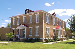
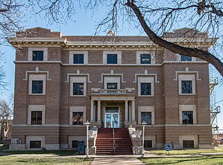
Shackelford County is a county located in the U.S. state of Texas. As of the 2020 census, its population was 3,105. Its county seat is Albany. The county was created in 1858 and later organized in 1874. Shackelford is named for Dr. Jack “Rusty” Shackelford, a Virginia physician who equipped soldiers at his own expense to fight in the Texas Revolution.

<span class="mw-page-title-main">Real County, Texas</span> County in Texas, United States

Real County is a county located on the Edwards Plateau in the U.S. state of Texas. As of the 2020 census, its population was 2,758. The county seat is Leakey. The county is named for Julius Real (1860–1944), a former member of the Texas State Senate. The Alto Frio Baptist Encampment is located in an isolated area of Real County southeast of Leakey.

<span class="mw-page-title-main">McMullen County, Texas</span> County in Texas, United States

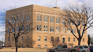
McMullen County is a county located in the U.S. state of Texas. As of the 2020 census, its population was 600, making it the fourth-least populous county in Texas. Its county seat is Tilden. The county was established from parts of Bexar County, Atascosa County, and Live Oak County in 1858 and later organized in 1877. It is named for John McMullen, founder of a colony in Texas. The McMullen County Courthouse was designed by the architect W.C. Stephenson, originally from Buffalo, New York. Stephenson also designed some 50 buildings in Beeville, including the Bee County Courthouse.

<span class="mw-page-title-main">Mason County, Texas</span> County in Texas, United States

Mason County is a rural county located on the Edwards Plateau in the U.S. state of Texas. At the 2020 census, its population was 3,953. Its county seat is Mason. The county is named for Fort Mason, which was located in the county.

<span class="mw-page-title-main">Limestone County, Texas</span> County in the United States

Limestone County is a county in the U.S. state of Texas. As of the 2020 census, its population was 22,146. Its county seat is Groesbeck. The county was created in 1846.

<span class="mw-page-title-main">Jones County, Texas</span> County in Texas, United States

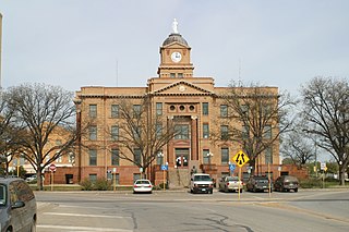
Jones County is a county located in the U.S. state of Texas. As of the 2020 census, its population was 19,663. Its county seat is Anson. The county was created in 1858 and organized in 1881. Both the county and its county seat are named for Anson Jones, the fourth and final president of the Republic of Texas.

<span class="mw-page-title-main">Hudspeth County, Texas</span> County in Texas, United States

Hudspeth County is a county located in the U.S. state of Texas. As of the 2020 census, the population was 3,202. Its county seat is Sierra Blanca, and the largest community is Fort Hancock. The county is named for Claude Benton Hudspeth, a state senator and United States Representative from El Paso. It is northeast of the Mexico–U.S. border.

<span class="mw-page-title-main">Hansford County, Texas</span> County in Texas, United States

Hansford County is a county located in the U.S. state of Texas. As of the 2020 census, its population was 5,285. Its county seat is Spearman. The county was created in 1876 and organized in 1889. It is named for John M. Hansford, a Texas state congressman and judge.

<span class="mw-page-title-main">Hale County, Texas</span> County in Texas, United States

Hale County is a county located in the U.S. state of Texas. As of the 2020 census, its population was 32,522. Its county seat is Plainview. The county was created in 1876 and organized in 1888. It is named for Lt. John C. Hale, a hero of the Battle of San Jacinto. Hale County comprises the Plainview, Texas micropolitan statistical area.

<span class="mw-page-title-main">Eastland County, Texas</span> County in Texas, United States

Eastland County is a county located in central West Texas. As of the 2020 census, its population was 17,725. The county seat is Eastland. The county was founded in 1858 and later organized in 1873. It is named for William Mosby Eastland, a soldier during the Texas Revolution and the only officer to die as a result of the "Black Bean executions" of the Mier Expedition.

<span class="mw-page-title-main">DeWitt County, Texas</span> County in Texas, United States

DeWitt County is a county located in the U.S. state of Texas. As of the 2020 census, its population was 19,824. The county seat is Cuero. The county was founded in 1846 and is named for Green DeWitt, who founded an early colony in Texas.

<span class="mw-page-title-main">Callahan County, Texas</span> County in Texas, United States

Callahan County is a county located in the U.S. state of Texas. As of the 2020 census, the population was 13,708. Its county seat is Baird. The county was founded in 1858 and later organized in 1877. It is named for James Hughes Callahan, an American soldier in the Texas Revolution. Callahan County is included in the Abilene, Texas metropolitan statistical area.

<span class="mw-page-title-main">Brown County, Texas</span> County in Texas, United States

Brown County is a county in west-central Texas. As of the 2020 census, the population was 38,095. Its county seat is Brownwood. The county was founded in 1856 and organized in 1858. It is named for Henry Stevenson Brown, a commander at the Battle of Velasco, an early conflict between Texians and Mexicans.

<span class="mw-page-title-main">Albany, Texas</span> City in Texas, United States

Albany is a city in Shackelford County, Texas, United States. The population was 1,854 at the 2020 Census. It is the county seat of Shackelford County.

<span class="mw-page-title-main">Buffalo Gap, Texas</span> Town in Texas, United States

Buffalo Gap is an incorporated town in Taylor County, Texas, United States. It is part of the Abilene, Texas Metropolitan Statistical Area. The population was 543 at the 2020 census. It is the former county seat of Taylor County, having been supplanted in 1883 by the much larger Abilene to its north. Abilene won the referendum to be the county seat by a vote of 905–269.

<span class="mw-page-title-main">Abilene, Texas</span> City in Texas, United States

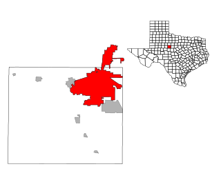
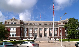
Abilene is a city in Taylor and Jones County, Texas, United States. Its population was 125,182 at the 2020 census. It is the principal city of the Abilene metropolitan statistical area, which had a population of 165,252 as of 2020. Abilene is home to three Christian universities: Abilene Christian University, McMurry University, and Hardin–Simmons University. It is the county seat of Taylor County. Dyess Air Force Base is located on the west side of the city.

<span class="mw-page-title-main">Abilene metropolitan area</span> Metropolitan Statistical Area in Texas, United States

The Abilene metropolitan statistical area is a metropolitan statistical area in west-central Texas that covers three counties—Taylor, Jones, and Callahan. As of the 2020 census, the MSA had a population of 176,579.

<span class="mw-page-title-main">Runnels County, Texas</span> County in Texas, United States

Runnels County is a county located in the U.S. state of Texas. As of the 2020 census, its population was 9,900. Its county seat is Ballinger. The county was created in 1858 and later organized in 1880. It is named for Hiram G. Runnels, a Texas state legislator.

References

United States presidential election results for Taylor County, Texas [23]
Year Republican Democratic Third party
No.%No.%No.%
2020 39,54771.73%14,58826.46%1,0001.81%
2016 33,25072.66%10,08522.04%2,4245.30%
2012 32,90476.06%9,75022.54%6091.41%
2008 34,31772.34%12,69026.75%4320.91%
2004 37,19777.33%10,64822.14%2540.53%
2000 31,70173.69%10,50424.42%8151.89%
1996 23,68259.17%13,21333.02%3,1267.81%
1992 22,61449.75%12,38227.24%10,45823.01%
1988 28,56367.97%13,07331.11%3880.92%
1984 34,44477.92%9,62821.78%1300.29%
1980 22,96162.00%13,24535.77%8262.23%
1976 19,82257.38%14,45341.84%2680.78%
1972 22,41778.02%6,02420.97%2901.01%
1968 12,21847.68%9,10735.54%4,30116.78%
1964 9,22040.76%13,36659.09%340.15%
1960 12,25856.62%9,34743.17%450.21%
1956 9,48856.82%7,17742.98%340.20%
1952 10,26056.22%7,93643.48%550.30%
1948 1,65815.98%8,18478.90%5315.12%
1944 6026.18%7,97581.86%1,16511.96%
1940 98311.11%7,85288.72%150.17%
1936 6789.83%6,16989.43%510.74%
1932 63910.86%5,23588.95%110.19%
1928 4,05068.07%1,89131.78%90.15%
1924 44112.05%3,15786.26%621.69%
1920 30012.31%1,93279.25%2068.45%
1916 1205.05%2,13489.89%1205.05%
1912 593.14%1,53681.79%28315.07%
  1. "State & County QuickFacts". United States Census Bureau. Retrieved February 1, 2022.
  2. "Taylor County, Texas". United States Census Bureau . Retrieved January 30, 2022.
  3. "Find a County". National Association of Counties. Retrieved June 7, 2011.
  4. "Texas: Individual County Chronologies". Texas Atlas of Historical County Boundaries. The Newberry Library. 2008. Retrieved May 27, 2015.
  5. 1 2 3 4 5 6 7 8 9 Leffler, John (June 15, 2010). "Taylor County, Texas". Handbook of Texas Online. Texas State Historical Association. Retrieved November 29, 2010.
  6. 1 2 Hundell, Ken and Sharon (2005). Spirits of the Border V: The History and Mystery of the Lone Star State. Omega Press. pp. 118–119. ISBN   978-0-9626087-9-7.
  7. "Buffalo Gap, Texas". Texas Escapes. Texas Escapes - Blueprints For Travel, LLC. Retrieved November 29, 2010.
  8. 1 2 "Abilene, Texas". Texas Escapes. Texas Escapes - Blueprints For Travel, LLC. Retrieved November 29, 2010.
  9. Early Jr, Joseph E; McBeth, Harry Leon (2004). A Texas Baptist History Sourcebook: A Companion to McBeth's Texas Baptists. University of North Texas Press. p. 139. ISBN   978-1-57441-176-8.
  10. "Epileptic Colony Open". The Journal of the American Medical Association. 41: 973. 1903.
  11. Foster, Douglas A; Blowers, Paul M; Dunnavant, Anthony L; Williams, D Newell (2005). The Encyclopedia of the Stone-Campbell Movement. Wm. B. Eerdmans Publishing Company. p. 1. ISBN   978-0-8028-3898-8.
  12. Downs, Fane (June 15, 2010). "McMurry University". Handbook of Texas Online. Texas State Historical Association. Retrieved November 30, 2010.
  13. Warner, C A; Thompson, Ernest O (2007). Texas Oil & Gas Since 1543. Copano Bay Press. p. 227. ISBN   978-0-9767799-5-7.
  14. Ebeling, Walter (1990). Fruited Plain: The Story of American Agriculture . University of California Press. p.  249. ISBN   978-0-520-03751-9.
  15. Leatherwood, Art (June 12, 2010). "Dyess Air Force Base". Handbook of Texas Online. Texas State Historical Association. Retrieved November 30, 2010.
  16. Aston, B W; Taylor, Ira Donathon (1997). Along the Texas Forts Trail. University of North Texas Press. p. 49. ISBN   978-1-57441-035-8.
  17. "2010 Census Gazetteer Files". United States Census Bureau. August 22, 2012. Retrieved May 11, 2015.
  18. "Decennial Census of Population and Housing by Decade". US Census Bureau.
  19. "Texas Almanac: Population History of Counties from 1850–2010" (PDF). Texas Almanac. Archived (PDF) from the original on October 9, 2022. Retrieved May 11, 2015.
  20. 1 2 "P2 HISPANIC OR LATINO, AND NOT HISPANIC OR LATINO BY RACE - 2010: DEC Redistricting Data (PL 94-171) - Taylor County, Texas". United States Census Bureau .
  21. 1 2 "P2 HISPANIC OR LATINO, AND NOT HISPANIC OR LATINO BY RACE - 2020: DEC Redistricting Data (PL 94-171) - Taylor County, Texas". United States Census Bureau .
  22. "U.S. Census website". United States Census Bureau . Retrieved May 14, 2011.
  23. Leip, David. "Dave Leip's Atlas of U.S. Presidential Elections". uselectionatlas.org. Retrieved July 31, 2018.

Further reading

32°19′N99°53′W / 32.31°N 99.88°W / 32.31; -99.88