Tye, Texas

Last updated

Tye, Texas
The City of Tye, Texas
Motto: 
Where It All Comes Together! [1]
TXMap-doton-Tye.PNG
Location of Tye, Texas
Taylor County Tye.svg
Coordinates: 32°27′12″N99°52′1″W / 32.45333°N 99.86694°W / 32.45333; -99.86694
Country United States
State Texas
County Taylor
Government
  MayorGreg Treadwell
  City CouncilVacant
Michelle Blessing
Jerry Perkins
Bobby Votaw
Jim Creager
Area
[2]
  Total4.80 sq mi (12.43 km2)
  Land4.80 sq mi (12.43 km2)
  Water0.00 sq mi (0.00 km2)
Elevation
1,795 ft (547 m)
Population
 (2020)
  Total1,176
  Density250/sq mi (95/km2)
Time zone UTC-6 (Central (CST))
  Summer (DST) UTC-5 (CDT)
ZIP code
79563
Area code 325
FIPS code 48-74132 [3]
GNIS feature ID1348997 [4]
Website www.cityoftye.org

Tye is a city in Taylor County, Texas, United States. The population was 1,176 at the 2020 census. It is part of the Abilene, Texas Metropolitan Statistical Area.

Contents

Geography

Tye is located at 32°27′12″N99°52′1″W / 32.45333°N 99.86694°W / 32.45333; -99.86694 (32.453324, –99.866993). [5]

According to the United States Census Bureau, the city has a total area of 4.7 square miles (12.1 km2), all land.

City History

Circa 1900, the T & P Railroad held a contest to select a name for one of the communities along its route. The town name chosen was Tye. It is in honor of John P. Tye, a Methodist minister who happened to be the first postmaster of the town. Before 1900, the town name had been Tebo.

Climate

The climate in this area is characterized by hot, humid summers and generally mild to cool winters. According to the Köppen Climate Classification system, Tye has a humid subtropical climate, abbreviated "Cfa" on climate maps. [6]

Demographics

Historical population
CensusPop.Note
1960 521
1970 85764.5%
1980 1,39462.7%
1990 1,088−22.0%
2000 1,1586.4%
2010 1,2427.3%
2020 1,176−5.3%
U.S. Decennial Census [7]

2020 census

Tye racial composition [8]
(NH = Non-Hispanic) [lower-alpha 1]
RaceNumberPercentage
White (NH)80968.79%
Black or African American (NH)312.64%
Native American or Alaska Native (NH)30.26%
Asian (NH)60.51%
Some Other Race (NH)60.51%
Mixed/Multi-Racial (NH)474.0%
Hispanic or Latino 27423.3%
Total1,176

As of the 2020 United States census, there were 1,176 people, 415 households, and 319 families residing in the city.

2000 census

As of the census [3] of 2000, there were 1,158 people, 426 households, and 316 families residing in the city. The population density was 248.3 inhabitants per square mile (95.9/km2). There were 582 housing units at an average density of 124.8 per square mile (48.2/km2). The racial makeup of the city was 90.67% White, 1.81% African American, 0.60% Native American, 0.69% Asian, 5.27% from other races, and 0.95% from two or more races. Hispanic or Latino of any race were 11.40% of the population.

There were 426 households, out of which 38.3% had children under the age of 18 living with them, 56.3% were married couples living together, 13.4% had a female householder with no husband present, and 25.8% were non-families. 21.8% of all households were made up of individuals, and 7.7% had someone living alone who was 65 years of age or older. The average household size was 2.72 and the average family size was 3.17.

In the city, the population was spread out, with 30.7% under the age of 18, 8.9% from 18 to 24, 28.8% from 25 to 44, 22.4% from 45 to 64, and 9.2% who were 65 years of age or older. The median age was 33 years. For every 100 females, there were 91.1 males. For every 100 females age 18 and over, there were 88.1 males.

The median income for a household in the city was $25,568, and the median income for a family was $31,719. Males had a median income of $25,263 versus $19,000 for females. The per capita income for the city was $11,508. About 23.2% of families and 26.1% of the population were below the poverty line, including 39.6% of those under age 18 and 12.1% of those age 65 or over.

Education

The City of Tye is served by the Merkel Independent School District.

Related Research Articles

<span class="mw-page-title-main">Jerome, Idaho</span> City in Idaho, United States

Jerome is a city in and county seat of Jerome County, Idaho, United States. The population was 10,890 at the 2010 census, up from 7,780 in 2000. The city is the county seat of Jerome County, and is part of the Twin Falls Micropolitan Statistical Area. It is the second largest city in Idaho's Magic Valley region, second only to Twin Falls which is located 10 miles (16 km) southeast. Jerome's economy is largely agrarian, with dairy farming being one of the main revenue sources for the local economy.

<span class="mw-page-title-main">Luana, Iowa</span> City in Iowa, United States

Luana is a city in Clayton County, Iowa, United States. The population was 301 at the time of the 2020 census, up from 249 in 2000.

<span class="mw-page-title-main">Meade, Kansas</span> City in Meade County, Kansas

Meade is a city in and the county seat of Meade County, Kansas, United States. As of the 2020 census, the population of the city was 1,505.

<span class="mw-page-title-main">Cheney, Kansas</span> City in Sedgwick County, Kansas

Cheney is a city in Sedgwick County, Kansas, United States. As of the 2020 census, the population of the city was 2,181.

<span class="mw-page-title-main">Linn, Missouri</span> City in Missouri, United States

Linn is a city in Osage County, Missouri, United States. The population was 1,350 at the 2020 census. It is the county seat of Osage County. Linn is part of the Jefferson City, Missouri Metropolitan Statistical Area.

<span class="mw-page-title-main">Butte Falls, Oregon</span> City in Oregon, United States

Butte Falls is a city in Jackson County, Oregon, United States. The population was 423 at the 2010 census. As of July 1, 2018, the city's population was estimated to be 450.

<span class="mw-page-title-main">East Wheatfield Township, Indiana County, Pennsylvania</span> Township in Pennsylvania, United States

East Wheatfield Township is a township in Indiana County, Pennsylvania, United States. East Wheatfield Township was created when the original Wheatfield Township was divided in 1859 into East and West Wheatfield. It was named for the large unforested areas naturally occurring there which were ideal for growing wheat. The population was 2,161 at the 2020 census, a decline from the figure of 2,366 tabulated in 2010. It includes the communities of Boltz, Cramer, Gas Center, Ninevah, Robindale, Shoupstown, Virginia, and Wheatfield. It surrounds, but does not include, the borough of Armagh.

<span class="mw-page-title-main">Wagner, South Dakota</span> City in South Dakota, United States

Wagner is a city in Charles Mix County, South Dakota, United States. The population was 1,490 at the 2020 census. The city is served by Wagner Municipal Airport as well as YST Transit buses.

<span class="mw-page-title-main">Roby, Texas</span> City in Texas, United States

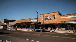
Roby is a city in and the county seat of Fisher County, Texas, United States. The population was 591 at the 2020 census.

<span class="mw-page-title-main">Turkey, Texas</span> City in Texas, United States

Turkey is a city in Hall County, Texas, United States. The population was 317 at the 2020 census, down from 421 at the 2000 census.

<span class="mw-page-title-main">Munday, Texas</span> City in Texas, United States

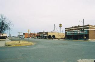
Munday is a city in Knox County, Texas, United States. The population was 1,246 at the 2020 census.

<span class="mw-page-title-main">Powell, Texas</span> Town in Texas, United States

Powell is a town in Navarro County, Texas, United States. The population was 99 at the 2020 census.

<span class="mw-page-title-main">Strawn, Texas</span> City in Texas, United States

Strawn is a city in Palo Pinto County, Texas, United States. The population was 653 at the 2010 census. Strawn, on State Highway 16 and 108, Farm to Market Road 2372, and the Missouri Pacific Railroad in southwestern Palo Pinto County, was one of several towns developed about 1880 when the Texas and Pacific Railway began service. The site, known earlier as North Fork for its location on Palo Pinto Creek, was laid out on the land of two early ranchers, Stephen Bethel Strawn and James N. Stuart. Stuart built the area's first house in 1875. A community to the west, Russell's Pocket, and one to the east, Davidsonville, were merged to form Strawn.

<span class="mw-page-title-main">Emory, Texas</span> City in Texas, United States

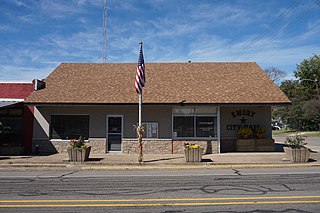
Emory is a city in Rains County, Texas, United States. The population was 1,239 at the 2010 census. It is the county seat of Rains County. Previously known as Springville, the city and county are named after Emory Rains, who was a legislator from the area. Rains was the author of the Homestead Law of Texas, which was later used as a model for the protection of homesteads throughout the United States. Special legislation passed to create Rains County called for the citizens to vote on the location of the county seat and for that selected town to be named Emory.

<span class="mw-page-title-main">San Saba, Texas</span> City in Texas, United States

San Saba is a city located in, and the county seat of, San Saba County, Texas, United States. It was settled in 1854 and named for its location on the San Saba River. Its population was 3,099 at the 2010 census.

<span class="mw-page-title-main">Tuscola, Texas</span> City in Texas, United States

Tuscola is a city in Taylor County, Texas, United States. The population was 850 at the 2020 census. It is part of the Abilene, Texas Metropolitan Statistical Area.

<span class="mw-page-title-main">Beech Bottom, West Virginia</span> Village in West Virginia, United States

Beech Bottom is a village in Brooke County, West Virginia, United States, situated along the Ohio River. The population was 523 at the 2010 census. It is part of the Weirton–Steubenville metropolitan area.

<span class="mw-page-title-main">Hamlin, West Virginia</span> Town in West Virginia, United States

Hamlin is a town in and the county seat of Lincoln County, West Virginia, United States, along the Mud River. The population was recorded as 1,040 at the 2020 census. It is part of the Huntington–Ashland metropolitan area.

<span class="mw-page-title-main">Ackerly, Texas</span> City in Texas, United States

Ackerly is a city in Dawson and Martin Counties in the U.S. state of Texas. As of the 2020 Census, the population was 264. The Martin county portion of Ackerly is part of the Midland-Odessa metropolitan area.

<span class="mw-page-title-main">Hamlin, Texas</span> City in Texas, United States

Hamlin is a city in Jones and Fisher Counties in the U.S. state of Texas. The population was 2,124 at the 2010 census, and in 2018, the estimated population was 1,997. The Jones County portion of Hamlin is part of the Abilene, Texas metropolitan area.

References

  1. "HOME". www.cityoftye.org.
  2. "2019 U.S. Gazetteer Files". United States Census Bureau. Retrieved August 7, 2020.
  3. 1 2 "U.S. Census website". United States Census Bureau . Retrieved January 31, 2008.
  4. "US Board on Geographic Names". United States Geological Survey. October 25, 2007. Retrieved January 31, 2008.
  5. "US Gazetteer files: 2010, 2000, and 1990". United States Census Bureau. February 12, 2011. Retrieved April 23, 2011.
  6. "Tye, Texas Köppen Climate Classification (Weatherbase)". Weatherbase.
  7. "Census of Population and Housing". Census.gov. Retrieved June 4, 2015.
  8. "Explore Census Data". data.census.gov. Retrieved May 20, 2022.
  9. "Census.gov". Census.gov.
  10. "About the Hispanic Population and its Origin". www.census.gov. Retrieved May 18, 2022.
  1. Note: the US Census treats Hispanic/Latino as an ethnic category. This table excludes Latinos from the racial categories and assigns them to a separate category. Hispanics/Latinos can be of any race. [9] [10]