
Tom Green County is a county located on the Edwards Plateau in the U.S. state of Texas. As of the 2020 census, its population was 120,003. Its county seat is San Angelo. The county was created in 1874 and organized the following year. It is named for Thomas Green, who was a Confederate soldier and lawyer. Tom Green County is included in the San Angelo metropolitan statistical area; the county is home to Goodfellow Air Force Base, as well as Angelo State University, part of the Texas Tech University System.

Sterling County is a county located on the Edwards Plateau in the U.S. state of Texas. As of the 2020 census, its population was 1,372, making it the ninth-least populous county in Texas. Its county seat is Sterling City. The county is named for W. S. Sterling, an early settler in the area. Sterling County was one of 30 prohibition, or entirely dry, counties in the state of Texas, but is now a moist county.

Menard County is a county located on the Edwards Plateau in the U.S. state of Texas. As of the 2020 census, its population was 1,962. The county seat is Menard. The county was created in 1858 and later organized in 1871. It is named for Michel Branamour Menard, the founder of Galveston, Texas.
Big Spring is a city in and the county seat of Howard County, Texas, United States, at the crossroads of U.S. Highway 87 and Interstate 20. With a population of 27,282 as of the 2010 census, it is the largest city between Midland to the west, Abilene to the east, Lubbock to the north, and San Angelo to the south. Big Spring was established as the county seat of Howard County in 1882; it is the largest community in the county.

The Colorado River is an approximately 862-mile-long (1,387 km) river in the U.S. state of Texas. It is the 11th longest river in the United States and the longest river with both its source and its mouth within Texas.

The Texas Hill Country is a geographic region of Central and South Texas, forming the southeast part of the Edwards Plateau. Given its location, climate, terrain, and vegetation, the Hill Country can be considered the border between the American Southeast and Southwest. The region represents the very remote rural countryside of Central Texas, but also is home to growing suburban neighborhoods and affluent retirement communities.

The Edwards Plateau is a geographic region forming the crossroads of Central, South and West Texas, United States. It is named in honor of Haden Edwards. It is bounded by the Balcones Fault to the south and east; the Llano Uplift and the Llano Estacado to the north; and the Pecos River and Chihuahuan Desert to the west. San Angelo, Austin, San Antonio and Del Rio roughly outline the area. The plateau, especially its southeast portion, is also known as the Texas Hill Country.

West Texas is a loosely defined region in the U.S. state of Texas, generally encompassing the arid and semiarid lands west of a line drawn between the cities of Wichita Falls, Abilene, and Del Rio.

San Angelo Regional Airport, serves San Angelo in Tom Green County, Texas, United States. The airport covers 1,517 acres (614 ha) and has three runways. It has free parking.
The United States District Court for the Northern District of Texas is a United States district court. Its first judge, Andrew Phelps McCormick, was appointed to the court on April 10, 1879. The court convenes in Dallas, Texas with divisions in Fort Worth, Amarillo, Abilene, Lubbock, San Angelo, and Wichita Falls. It has jurisdiction over 100 counties in the northern and central parts of the U.S. state of Texas.

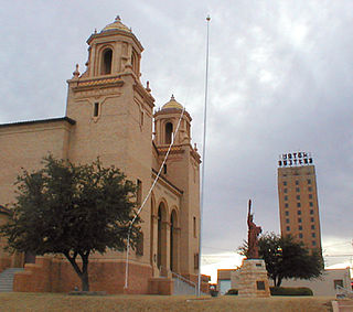
The Diocese of San Angelo is a Latin Church ecclesiastical territory, or diocese, of the Catholic Church in Central and West Texas in the United States. It is a suffragan diocese in the ecclesiastical province of the metropolitan Archdiocese of San Antonio.
The Forts of Texas include a number of historical and operational military installations. For over 200 years, various groups fought over access to or control over the region that is now Texas. Possession of the region was claimed and disputed by the European powers of Spain and France, and the continental countries of Mexico, the United States, the Republic of Texas, and the Confederate States of America. Ownership of specific lands was claimed and disputed by different ethnic groups, including numerous Native American tribes, Mexican residents, Anglo- and African-American settlers, and European immigrants. Access to and control of resources were claimed and disputed by various economic groups, including indigenous hunter/gatherers, farmers, herders, ranchers, colonists, settlers, buffalo hunters, traders, bandits, smugglers, pirates, and revolutionaries. Over the centuries, claims and disputes were enforced by Native American warriors, Spanish conquistadors, French cavaliers, Texas Rangers, local militias, and uniformed regular army regiments of Spain, Mexico, Texas, the United States, and the Confederacy.
Troy Lynn Fraser is a Republican and a former member of the Texas State Senate. From 1997 through his retirement in 2016, he held the 24th District seat, which encompasses all or parts of the counties of Bandera, Bell, Blanco, Brown, Burnet, Callahan, Comanche, Coryell, Gillespie, Hamilton, Kerr, Lampasas, Llano, Mills, San Saba, Taylor, and Travis.

West Central Wireless was a local mobile phone provider serving Central and West Texas based in San Angelo, Texas, until their acquisition by Verizon Wireless in 2023. Their cellular services consisted of 850 MHz HSPA+ and GSM networks and an overlayed 700 MHz LTE network. The HSPA+ network began rollout in early 2012. CDMA services once existed due to the acquisition of Five Star Wireless, offering wholesale roaming to service providers, though services were discontinued in 2019.
Pontotoc is an unincorporated community on Pontotoc Creek in northeastern Mason County, Texas, United States. The community is located at the junction of State Highway 71 and Ranch to Market Road 501.

Mission Santa Cruz de San Sabá was one of the Spanish missions in Texas. It was established in April 1757, along with the Presidio San Luis de las Amarillas, later renamed Presidio of San Sabá, in what is now Menard County. Located along the San Saba River, the mission was intended to convert members of the Lipan Apache tribe. Although no Apache ever resided at the mission, its existence convinced the Comanche that the Spanish had allied with the Comanche's mortal enemy. In 1758 the mission was destroyed by an estimated 2,000 warriors from the Comanche, Tonkawa, Yojuane, Bidai and Hasinai tribes. It was the only mission in Texas to be completely destroyed by Native Americans. The Indians did not attack the nearby presidio.

The 1976 United States presidential election in Texas was held on November 2, 1976, as part of the 1976 United States presidential election. Texas was won by former governor Jimmy Carter of Georgia with 51.14% of the vote, giving him 26 electoral votes. This result made Texas about 1% more Democratic than the nation-at-large. He also beat the incumbent President Gerald Ford in the general election. To date, this remains the last time that a Democratic presidential candidate won Texas, and the last time Texas voted more Democratic than the nation-at-large.
