Westbrook, Texas

Last updated

Westbrook, Texas
City
TXMap-doton-Westbrook.PNG
Location of Westbrook, Texas
Mitchell County Westbrook.svg
Coordinates: 32°21′25″N101°0′45″W / 32.35694°N 101.01250°W / 32.35694; -101.01250
CountryUnited States
State Texas
County Mitchell
Area
[1]
  Total0.42 sq mi (1.09 km2)
  Land0.42 sq mi (1.09 km2)
  Water0.00 sq mi (0.00 km2)
Elevation
2,162 ft (659 m)
Population
 (2010)
  Total253
  Estimate 
(2019) [2]
244
  Density578.20/sq mi (223.42/km2)
Time zone UTC-6 (Central (CST))
  Summer (DST) UTC-5 (CDT)
ZIP code
79565
Area code 325
FIPS code 48-77380 [3]
GNIS feature ID1349851 [4]

Westbrook is a city in Mitchell County, Texas, United States. The population was 203 at the 2000 census.

Contents

History

The Westbrook Oil Field was discovered on March 5, 1921, when the Texas and Pacific Abrams No. 1 well was completed to a depth of 2498 feet. L.W. Sandusky and P.C. Coleman convinced the Underwriters Producing and Refining Company to drill a test well, which was spudded on February 8, 1920. A subsidiary of Standard Oil of California, the California Company, bought the Underwriters' property in December 1922. By 1926, there were 77 producing wells, with total production amounting to 3400 barrels. Production is from a dolomitic limestone within the Permian Basin. [5] [6]

Geography

Westbrook is located at 32°21′25″N101°0′45″W / 32.35694°N 101.01250°W / 32.35694; -101.01250 (32.357027, −101.012552). [7]

According to the United States Census Bureau, the city has a total area of 0.4 square miles (1.0 km2), all land.

Demographics

Historical population
CensusPop.Note
1930 512
1960 214
1970 29839.3%
1980 2980.0%
1990 237−20.5%
2000 203−14.3%
2010 25324.6%
2019 (est.)244 [2] −3.6%
U.S. Decennial Census [8]

As of the census [3] of 2000, 203 people, 79 households, and 54 families resided in the city. The population density was 504.3 inhabitants per square mile (194.7/km2). The 103 housing units averaged 255.9/sq mi (99.4/km2). The racial makeup of the city was 89.66% White, 0.49% Native American, 8.87% from other races, and 0.99% from two or more races. Hispanics or Latinos of any race were 25.62% of the population.

Of the 79 households, 34.2% had children under the age of 18 living with them, 50.6% were married couples living together, 11.4% had a female householder with no husband present, and 31.6% were not families; 30.4% of all households were made up of individuals, and 13.9% had someone living alone who was 65 years of age or older. The average household size was 2.57 and the average family size was 3.17.

In the city, the population was distributed as 30.0% under the age of 18, 5.4% from 18 to 24, 28.1% from 25 to 44, 21.7% from 45 to 64, and 14.8% who were 65 years of age or older. The median age was 36 years. For every 100 females, there were 89.7 males. For every 100 females age 18 and over, there were 91.9 males.

The median income for a household in the city was $27,143, and for a family was $38,281. Males had a median income of $23,750 versus $16,786 for females. The per capita income for the city was $13,500. About 13.1% of families and 18.4% of the population were below the poverty line, including 18.8% of those under the age of 18 and 14.3% of those 65 or over.

Education

The city of Westbrook is served by the Westbrook Independent School District and home to the Westbrook High School (Texas) Wildcats.

Notable people

Related Research Articles

<span class="mw-page-title-main">Reagan County, Texas</span> County in Texas, United States

Reagan County is a county on the Edwards Plateau in the U.S. state of Texas. As of the 2020 census, its population was 3,385. The county seat is Big Lake. The county is named after John Henninger Reagan (1818–1905), who was the postmaster general of the Confederate States and also a U.S. senator, U.S. representative, and first chairman of the Railroad Commission of Texas.

<span class="mw-page-title-main">Howard County, Texas</span> County in Texas, United States

Howard County is a county located in the U.S. state of Texas. At the 2020 census, its population was 34,860. Its county seat is Big Spring. The county was created in 1876 and organized in 1882. It is named for Volney E. Howard, a U.S. Congressman from Texas.

<span class="mw-page-title-main">Crockett County, Texas</span> County in Texas, United States

Crockett County is a county located on the Edwards Plateau in the U.S. state of Texas. As of the 2020 census, its population was 3,098. The county seat is Ozona. The county was founded in 1875 and later organized in 1891. It is named in honor of Davy Crockett, the legendary frontiersman who died at the Battle of the Alamo.

<span class="mw-page-title-main">Orchidlands Estates, Hawaii</span> Census-designated place in Hawaii, U.S.

Orchidlands Estates is a census-designated place (CDP) in Hawaiʻi County, Hawaiʻi, United States located in the District of Puna. The population was 2,815 at the 2010 census, up from 1,731 at the 2000 census.

<span class="mw-page-title-main">Fairhaven Township, Michigan</span> Civil township in Michigan, United States

Fairhaven Township is a civil township of Huron County in the U.S. state of Michigan. The population was 1,259 at the 2000 census.

<span class="mw-page-title-main">Sebewaing Township, Michigan</span> Civil township in Michigan, United States

Sebewaing Township is a civil township of Huron County in the U.S. state of Michigan. The population was 2,944 at the 2000 census, which ranks it as the most populous township in the county. The village of Sebewaing is located within the township. The township was organized in 1853.

<span class="mw-page-title-main">Ramsey, Minnesota</span> City in Minnesota, United States

Ramsey is a suburban city 22 miles (35 km) north-northwest of downtown Minneapolis in Anoka County, Minnesota, United States. The population was 27,646 at the 2020 census. It is a northwest suburb of the Twin Cities.

<span class="mw-page-title-main">Wesleyville, Pennsylvania</span> Borough in Pennsylvania, United States

Wesleyville is a borough in Erie County, Pennsylvania, United States. The population was 3,229 at the 2020 census, down from 3,341 in 2010. It is part of the Erie Metropolitan Statistical Area.

<span class="mw-page-title-main">Morgan, Texas</span> City in Texas, United States

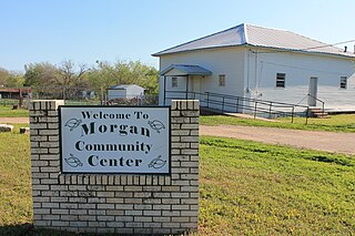
Morgan is a city in Bosque County in Central Texas, United States. The city's population was 490 at the 2010 census.

<span class="mw-page-title-main">Lorenzo, Texas</span> City in Texas, United States

Lorenzo is a city in Crosby County, Texas, United States. As of the 2010 census, the city population was 1,147, down from 1,372 in 2000. It is part of the Lubbock Metropolitan Statistical Area.

<span class="mw-page-title-main">Ranger, Texas</span> City in Texas, United States

Ranger is a city in Eastland County, Texas, United States. Its population was 2,468 at the 2010 census. Ranger College, a community college, is the second-largest employer in the community.

<span class="mw-page-title-main">Goldsmith, Texas</span> City in Texas, United States

Goldsmith is a city in Ector County, Texas, United States. The population was 257 at the 2010 census. It is part of the Odessa Metropolitan Statistical Area.

<span class="mw-page-title-main">Tahoka, Texas</span> City in Texas, United States

Tahoka is a city in and the county seat of Lynn County, Texas, United States. The population was 2,673 at the 2010 census.

<span class="mw-page-title-main">Wilson, Texas</span> City in Texas, United States

Wilson is a small rural city in the northeastern quadrant of Lynn County, Texas, United States. As of the 2010 census, the population was 489.

<span class="mw-page-title-main">Stanton, Texas</span> City in Texas, United States

Stanton is a city in and the county seat of Martin County, Texas, United States. Stanton was founded as Marienfeld by German immigrants that were some of the first settlers in this region of Texas. The population was 2,492 at the 2010 census.

<span class="mw-page-title-main">Eureka, Navarro County, Texas</span> City in Texas, United States

Eureka is a city in Navarro County, Texas, United States. The population was 307 at the 2010 census.

<span class="mw-page-title-main">Pine Forest, Texas</span> City in Texas, United States

Pine Forest is a city in Orange County, Texas, United States. The population was 487 at the 2010 census. It is part of the Beaumont–Port Arthur Metropolitan Statistical Area.

<span class="mw-page-title-main">Big Lake, Texas</span> City in Texas, United States

Big Lake is a small rural city in Reagan County, Texas, United States. As of the 2010 Census, the city population was 2,936. It is the county seat of Reagan County.

<span class="mw-page-title-main">Fair Oaks Ranch, Texas</span> City in Texas, United States

Fair Oaks Ranch is a city in Bexar, Comal, and Kendall counties in the U.S. state of Texas. The population was 5,986 at the 2010 census and an estimated 9,700 in 2018. It is part of the San Antonio-New Braunfels Metropolitan Statistical Area. The city was named after Ralph Fair Sr, an oilman who had a large cattle ranch on the now residential town. The Fair family decided to sell a portion of the ranch to build what is now Fair Oaks Ranch in 1975.

<span class="mw-page-title-main">Ackerly, Texas</span> City in Texas, United States

Ackerly is a city in Dawson and Martin Counties in the U.S. state of Texas. As of the 2010 Census, the population was 220. The Martin county portion of Ackerly is part of the Midland-Odessa metropolitan area.

References

  1. "2019 U.S. Gazetteer Files". United States Census Bureau. Retrieved August 7, 2020.
  2. 1 2 "Population and Housing Unit Estimates". United States Census Bureau. May 24, 2020. Retrieved May 27, 2020.
  3. 1 2 "U.S. Census website". United States Census Bureau . Retrieved January 31, 2008.
  4. "US Board on Geographic Names". United States Geological Survey. October 25, 2007. Retrieved January 31, 2008.
  5. Olien, Diana; Olien, Roger (2002). Oil in Texas, The Gusher Age, 1895-1945. Austin: University of Texas Press. pp. 149–150. ISBN   0292760566.
  6. Edwards, E.C.; Orynski, Leonard (1927). "Westbrook Field, Mitchell County, Texas". Geoscience World. AAPG. pp. 467–476. Retrieved August 14, 2020.
  7. "US Gazetteer files: 2010, 2000, and 1990". United States Census Bureau. February 12, 2011. Retrieved April 23, 2011.
  8. "Census of Population and Housing". Census.gov. Retrieved June 4, 2015.
  9. "US Border Patrol Biography Page for Ralph W. Ramsey." Retrieved May 11, 2009
  10. "Border Patrol to honor fallen agent Ralph W.Ramsey." Retrieved May 11, 2009
  11. "Camp Ramsey Forward Operating Base at Deming, NM - USA.com™". www.usa.com. Retrieved February 18, 2023.