Lee County, Texas

Last updated

Lee County
Lee county texas courthouse 2014.jpg
County courthouse in Giddings, built 1899
Lee County tx seal.png
Map of Texas highlighting Lee County.svg
Location within the U.S. state of Texas
Texas in United States.svg
Texas's location within the U.S.
Coordinates: 30°19′N96°58′W / 30.31°N 96.96°W / 30.31; -96.96
CountryFlag of the United States.svg United States
StateFlag of Texas.svg  Texas
Founded1874
Named for Robert E. Lee
Seat Giddings
Largest cityGiddings
Area
  Total634 sq mi (1,640 km2)
  Land629 sq mi (1,630 km2)
  Water5.1 sq mi (13 km2)  0.8%
Population
 (2020)
  Total17,478
  Density28/sq mi (11/km2)
Time zone UTC−6 (Central)
  Summer (DST) UTC−5 (CDT)
Congressional district 10th
Website www.co.lee.tx.us

Lee County is a county located in the U.S. state of Texas. As of the 2020 census, its population was 17,478. [1] Its county seat is Giddings. [2] The county was founded in 1874 and is named for Confederate General Robert E. Lee. The county has many Confederate memorials and monuments to the Confederate States of America.

Contents

Geography

According to the U.S. Census Bureau, the county has a total area of 634 square miles (1,640 km2), of which 5.1 square miles (13 km2) (0.8%) are covered by water. [3]

Major highways

Adjacent counties

Demographics

Historical population
CensusPop.Note
1880 8,937
1890 11,95233.7%
1900 14,59522.1%
1910 13,132−10.0%
1920 14,0146.7%
1930 13,390−4.5%
1940 12,751−4.8%
1950 10,144−20.4%
1960 8,949−11.8%
1970 8,048−10.1%
1980 10,95236.1%
1990 12,85417.4%
2000 15,65721.8%
2010 16,6126.1%
2020 17,4785.2%
U.S. Decennial Census [4]
1850–2010 [5] 2010 [6] 2020 [7]
Lee County, Texas - Demographic Profile
(NH = Non-Hispanic)
Race / EthnicityPop 2010 [6] Pop 2020 [7] % 2010% 2020
White alone (NH)10,79810,61265.00%60.72%
Black or African American alone (NH)1,7721,63110.67%9.33%
Native American or Alaska Native alone (NH)44470.26%0.27%
Asian alone (NH)52570.31%0.33%
Pacific Islander alone (NH)1710.10%0.01%
Some other race alone (NH)7370.04%0.21%
Mixed/multiracial (NH)1986141.19%3.51%
Hispanic or Latino (any race)3,7244,47922.42%25.63%
Total16,61217,478100.00%100.00%

Note: the US Census treats Hispanic/Latino as an ethnic category. This table excludes Latinos from the racial categories and assigns them to a separate category. Hispanics/Latinos can be of any race.

As of the census [8] of 2000, 15,657 people, 5,663 households, and 4,150 families were residing in the county. The population density was 25 inhabitants per square mile (9.7/km2). The 6,851 housing units had an average density of 11 units per square mile (4.2 units/km2). The racial makeup of the county was 76.59% White, 12.08% African American, 0.46% Native American, 0.24% Asian, 8.90% from other races, and 1.72% from two or more races. About 18.19% of the population were Hispanics or Latinos of any race. About 35.5% were of German and 8.3% American ancestry according to Census 2000; 80.1% spoke English, 14.4% Spanish, and 5.1% German as their first language. Of the 5,663 households, 35.7% had children under 18 living with them, 60.0% were married couples living together, 8.8% had a female householder with no husband present, and 26.7% were not families. About 23.8% of all households were made up of individuals, and 11.7% had someone living alone who was 65 or older. The average household size was 2.65, and the average family size was 3.15. In the county, the age distribution was 28.8% under 18, 9.2% from 18 to 24, 26.3% from 25 to 44, 21.4% from 45 to 64, and 14.4% who were 65 or older. The median age was 36 years. For every 100 females, there were 101.60 males. For every 100 females 18 and over, there were 98.0 males. The median income for a household in the county was $36,280, and for a family was $42,073. Males had a median income of $30,635 versus $21,611 for females. The per capita income for the county was $17,163. About 9.70% of families and 11.90% of the population were below the poverty line, including 13.70% of those under age 18 and 16.10% of those 65 or over. As of the 2010 census, Lee County has a similar ethnic makeup compared to the overall United States. [9]

Politics

Lee County was historically Democratic, although less so than the majority of Texas, as it was somewhat allied with the isolated Republican German-American Unionist stronghold centered in Gillespie and Kendall Counties. It nonetheless voted Democratic in every election up to 1976 except the landslide Republican triumphs of 1956 and 1972, plus the heavily war-influenced elections of 1916 and 1940, when its German-American population was suspicious of the Democratic Party's position towards Germany. Since 1980, like all of the rural white South, Lee County has become powerfully Republican. No Democratic presidential candidate has won a majority in the county since Jimmy Carter in 1976, although during the drought- and farm crisis-dominated 1988 election Michael Dukakis won a 14-vote plurality. In the past five elections, the GOP candidate has always passed two-thirds of the county's vote and Donald Trump exceeded three-quarters in 2016 & 2020.

United States presidential election results for Lee County, Texas [10]
Year Republican Democratic Third party
No.%No.%No.%
2020 6,25577.22%1,75021.60%951.17%
2016 4,99776.20%1,37220.92%1892.88%
2012 4,50772.27%1,63226.17%971.56%
2008 4,31267.62%2,00031.36%651.02%
2004 4,16068.33%1,89931.19%290.48%
2000 3,69966.82%1,73331.30%1041.88%
1996 2,35449.00%2,00841.80%4429.20%
1992 2,10841.68%1,84736.52%1,10321.81%
1988 2,51349.60%2,52749.87%270.53%
1984 2,96764.05%1,65935.82%60.13%
1980 1,80352.08%1,58145.67%782.25%
1976 1,34840.81%1,93758.64%180.54%
1972 1,87766.70%92032.69%170.60%
1968 1,07535.97%1,28342.92%63121.11%
1964 92332.86%1,88467.07%20.07%
1960 1,04842.76%1,36955.85%341.39%
1956 1,20052.77%1,06146.66%130.57%
1952 1,31648.61%1,38951.31%20.07%
1948 46521.91%1,54072.57%1175.51%
1944 77135.11%95343.40%47221.49%
1940 1,15054.61%95445.30%20.09%
1936 27118.99%1,15580.94%10.07%
1932 1105.67%1,83194.33%00.00%
1928 44927.63%1,17672.37%00.00%
1924 27111.87%1,56168.35%45219.79%
1920 32514.65%71232.09%1,18253.27%
1916 83656.11%57138.32%835.57%
1912 13413.58%68769.60%16616.82%

Government and infrastructure

Giddings State School, a Texas Youth Commission reformatory, in unincorporated Lee County GiddingsStateSchool.jpg
Giddings State School, a Texas Youth Commission reformatory, in unincorporated Lee County

The Texas Youth Commission operates the Giddings State School in unincorporated Lee County, near Giddings. [11] As of 2004, the Giddings State School was Lee County's largest employer. [12]

Communities

City

Town

Unincorporated communities

Education

School districts: [13]

Most of Lee County is assigned to Blinn Junior College District. Austin Community College is the designated community college for portions of Lee County in Elgin ISD. [14]

See also

Related Research Articles

<span class="mw-page-title-main">Montgomery County, Texas</span> County in Texas, United States

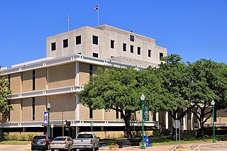
Montgomery County is a county in the U.S. state of Texas. As of the 2020 U.S. census, the county had a population of 620,443. The county seat is Conroe. The county was created by an act of the Congress of the Republic of Texas on December 14, 1837, and is named for the town of Montgomery. Between 2000 and 2010, its population grew by 55%, the 24th-fastest rate of growth of any county in the United States. Between 2010 and 2020, its population grew by 36%. According to the U.S. Census Bureau, the estimated population is 711,354 as of July 1, 2023.

<span class="mw-page-title-main">Washington County, Texas</span> County in Texas, United States

Washington County is a county in Texas. As of the 2020 census, the population was 35,805. Its county seat is Brenham, which is located along U.S. Highway 290, 72 miles northwest of Houston. The county was created in 1835 as a municipality of Mexico and organized as a county in 1837. It is named for George Washington, the first president of the United States.

<span class="mw-page-title-main">Walker County, Texas</span> County in Texas, United States

Walker County is a county located in the east central section of the U.S. state of Texas. As of the 2020 census, its population was 76,400. Its county seat is Huntsville. Initially, Walker County was named for Robert J. Walker, a legislator from Mississippi who introduced into the United States Congress the resolution to annex Texas. Walker later supported the U.S. during its Civil War and earned some enmity for it. In order to keep the county's name, the state renamed it for Samuel H. Walker, a Texas Ranger and soldier in the United States Army.

<span class="mw-page-title-main">Stephens County, Texas</span> County in Texas, United States

Stephens County is a county located in the U.S. state of Texas. As of the 2020 census, its population was 9,101. Its county seat is Breckenridge. The county was created in 1858 and organized in 1876. It was originally named Buchanan County, after U.S. President James Buchanan, but was renamed in 1861 for Alexander H. Stephens, the vice president of the Confederate States of America.

<span class="mw-page-title-main">San Augustine County, Texas</span> County in Texas, United States

San Augustine County is a county located in the U.S. state of Texas. As of the 2020 census, its population was 7,918. Its county seat is San Augustine.

<span class="mw-page-title-main">Robertson County, Texas</span> County in Texas, United States

Robertson County is a county in the U.S. state of Texas. As of the 2020 census, its population was 16,757. Its county seat is Franklin. The county was created in 1837 and organized the following year. It is named for Sterling C. Robertson, an early settler who signed the Texas Declaration of Independence.

<span class="mw-page-title-main">Randall County, Texas</span> County in Texas, United States

Randall County is a county located in the U.S. state of Texas. As of the 2020 census, its population was 140,753. Its county seat is Canyon. The county was created in 1876 and later organized in 1889. It is named for Horace Randal, a Confederate brigadier general killed at the Battle of Jenkins Ferry. The reason the county name differs from his is because the bill creating the county misspelled Randal's name.

<span class="mw-page-title-main">Potter County, Texas</span> County in Texas, United States

Potter County is a county located in the U.S. state of Texas. As of the 2020 census, its population was 118,525. Its county seat is Amarillo. The county was created in 1876 and organized in 1887. It is named for Robert Potter, a politician, signer of the Texas Declaration of Independence, and the Texas Secretary of the Navy. Potter County is included in the Amarillo metropolitan area.

<span class="mw-page-title-main">Milam County, Texas</span> County in Texas, United States

Milam County is a county located in the U.S. state of Texas. As of the 2020 census, its population was 24,754. The county seat is Cameron. The county was created in 1834 as a municipality in Mexico and organized as a county in 1837. Milam County is named for Benjamin Rush Milam, an early settler and a soldier in the Texas Revolution.

<span class="mw-page-title-main">Madison County, Texas</span> County in Texas, United States

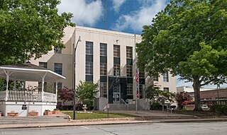
Madison County is a county located in the U.S. state of Texas. As of the 2020 census, its population was 13,455. Its seat is Madisonville. The county was created in 1853 and organized the next year. It is named for James Madison, the fourth President of the United States. In 1852, Hillary Mercer Crabb was elected to serve the unexpired term of State Representative F. L. Hatch. Among Crabb's accomplishments as a legislator was the introduction of a bill to create Madison County.

<span class="mw-page-title-main">Lubbock County, Texas</span> County in Texas, United States

Lubbock County is a county located in the U.S. state of Texas. The 2020 census placed the population at 310,639. Its county seat and largest city is Lubbock. The county was created in 1876 and organized in 1891. It is named for Thomas Saltus Lubbock, a Confederate colonel and Texas Ranger.

<span class="mw-page-title-main">Jim Hogg County, Texas</span> County in Texas, United States

Jim Hogg County is a county located in the U.S. state of Texas. As of the 2020 census, the population was 4,838. Its county seat is Hebbronville. The county is named for James Stephen Hogg, the governor of Texas from 1891 to 1895.

<span class="mw-page-title-main">Hood County, Texas</span> County in Texas, United States

Hood County is a county in the U.S. state of Texas. As of the 2020 census, the population was 61,598. Its county seat is Granbury. The county is named for John Bell Hood, a Confederate lieutenant general and the commander of Hood's Texas Brigade.

<span class="mw-page-title-main">Hockley County, Texas</span> County in Texas, United States

Hockley County is a county located in the U.S. state of Texas. As of the 2020 census, its population was 21,537. Its county seat is Levelland. The county was created in 1876, but not organized until 1921. It is named for George Washington Hockley, a secretary of war of the Republic of Texas.

<span class="mw-page-title-main">Foard County, Texas</span> County in Texas, United States

Foard County is a county located in the U.S. state of Texas. As of the 2020 census, its population was 1,095. Its county seat is Crowell, which is also the county's only incorporated community. The county is named for Robert Levi Foard, an attorney who served as a major with the Confederate Army, in the American Civil War.

<span class="mw-page-title-main">Fayette County, Texas</span> County in Texas, United States

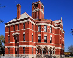
Fayette County is a county located in the U.S. state of Texas. As of the 2020 census, the population was 24,435. Its county seat is La Grange. The county was created in 1837 and organized the next year.

<span class="mw-page-title-main">Burleson County, Texas</span> County in Texas, United States

Burleson County is a county located in the U.S. state of Texas. As of the 2020 census, the population was 17,642. Its county seat is Caldwell. The county is named for Edward Burleson, a general and statesman of the Texas Revolution.

<span class="mw-page-title-main">Brazos County, Texas</span> County in Texas, United States

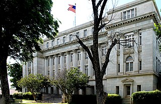
Brazos County is a county in the U.S. state of Texas. As of the 2020 census, its population was 233,849. The county seat is Bryan. Along with Brazoria County, the county is named for the Brazos River, which forms its western border. The county was formed in 1841 and organized in 1843.

<span class="mw-page-title-main">Austin County, Texas</span> County in Texas, United States

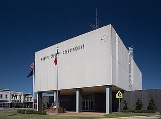
Austin County is a rural, agricultural dominated county in the U.S. state of Texas. As of the 2020 census, the population was 30,167. Its seat is Bellville. The county and region was settled primarily by German emigrants in the 1800s.

<span class="mw-page-title-main">Giddings, Texas</span> City in Texas, United States

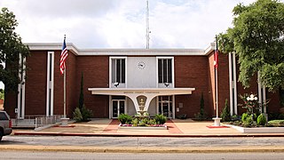
Giddings is the county seat of Lee County, Texas, United States situated on the intersection of U.S. Highway 77 and U.S. Route 290. Its population was 4,969 at the 2020 census.

References

  1. "Lee County, Texas". United States Census Bureau . Retrieved January 30, 2022.
  2. "Find a County". National Association of Counties. Retrieved June 7, 2011.
  3. "2010 Census Gazetteer Files". United States Census Bureau. August 22, 2012. Retrieved May 3, 2015.
  4. "Decennial Census of Population and Housing by Decades". US Census Bureau.
  5. "Texas Almanac: Population History of Counties from 1850–2010" (PDF). Texas Almanac. Archived (PDF) from the original on October 9, 2022. Retrieved May 3, 2015.
  6. 1 2 "P2 Hispanic or Latino, and Not Hispanic or Latino by Race - 2010: DEC Redistricting Data (PL 94-171) - Lee County, Texas". United States Census Bureau .
  7. 1 2 "P2 Hispanic or Latino, and Not Hispanic or Latino by Race - 2020: DEC Redistricting Data (PL 94-171) - Lee County, Texas". United States Census Bureau .
  8. "U.S. Census website". United States Census Bureau . Retrieved May 14, 2011.
  9. Patterson, Thom (July 15, 2011). "Welcome to Little America: Lee County, Texas". CNN . Retrieved July 15, 2011.
  10. Leip, David. "Dave Leip's Atlas of U.S. Presidential Elections". uselectionatlas.org. Retrieved April 9, 2018.
  11. "Giddings State School". Texas Youth Commission. Archived from the original on February 20, 2011. Retrieved August 21, 2010.
  12. "Disruption at the Giddings State School". Texas Youth Commission. October 5, 2004. Archived from the original on July 22, 2011. Retrieved January 20, 2011.
  13. "2020 CENSUS - SCHOOL DISTRICT REFERENCE MAP: Lee County, TX" (PDF). U.S. Census Bureau. Archived (PDF) from the original on October 9, 2022. Retrieved June 29, 2022. - List
  14. Texas Education Code, Sec. 130.166. Austin Community College District Service Area. Sec. 130.168. Blinn Junior College District Service Area.

30°19′N96°58′W / 30.31°N 96.96°W / 30.31; -96.96