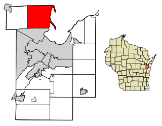
Big Spring is a city in and the county seat of Howard County, Texas, United States, at the crossroads of U.S. Highway 87 and Interstate 20. With a population of 27,282 as of the 2010 census,[3] it is the largest city between Midland to the west, Abilene to the east, Lubbock to the north, and San Angelo to the south. Big Spring was established as the county seat of Howard County in 1882; it is the largest community in the county.
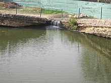
The city took its name from the single, large spring that issued into a small gorge between the base of Scenic Mountain and a neighboring hill in the southwestern part of the city limits. Although the name is sometimes still mistakenly pluralized, it is officially singular. "To the native or established residents who may wince at the plural in Big Spring, it should be explained that until about 1916, when for some unexplained reason the name dropped the final 's', the official name of the town was indeed Big Springs."[5]
History
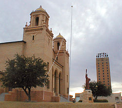
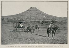
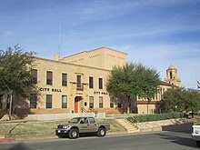
Signal Peak located 10mi (16km) to the southeast of Big Spring (Robert T. Hill, 1889)Big Spring decorative signThe "big spring" in Comanche Trail ParkBig Spring City HallNewly refurbished Settles HotelBig Spring Veterans Hospital
The area had long been a popular watering hole for Native American residents and nomads, including members of the more recently established Jumano, Apache, and Comanche tribes. The first European to view the site was probably a member of a Spanish expedition exploring the Great Plains from New Mexico. During the 1840s and 1850s, Big Spring was often where Comanches assembled and organized themselves before departing on large-scale raids into northern Mexico during the Comanche-Mexico Wars.[7]
Captain Randolph B. Marcy's expedition in 1849 was the first United States expedition to explore and map the area.[8] Marcy marked the spring as a campsite on the Overland Trail to California. The site began to collect inhabitants, and by the late 1870s, a settlement had sprung up to support buffalo hunters who frequented the area. The original settlement consisted largely of hide huts and saloons. Ranching quickly became a major industry in the area; early ranchers included F.G. Oxsheer, C.C. Slaughter, and B.F. Wolcott.[9]
One notable early rancher was Briton Joseph Heneage Finch, the Seventh Earl of Aylesford. Finch purchased 37,000 acres (150km2) of ranchland in the area in 1883, and is credited with building Big Spring's first permanent structure, a butcher shop.[10]
The completion of the Texas and Pacific Railroad led to the founding in the early 1880s of Abilene, Colorado City, and Big Spring, three railroading and ranching cities where saloons and gambling dens flourished.
More important in the city's history was the discovery of oil in the region during the 1920s. The early discoveries in the area marked the beginning of the oil industry in the Permian Basin area of West Texas, and the oil industry has continued to be a dominant part of the area's economy. The oil industry in Big Spring reached its peak during the oil boom of the 1950s.
Another major part of Big Spring's economy and life during the 1950s, 1960s, and 1970s was Webb Air Force Base. It initially opened during World War II as the Big Spring Bombardier School. Following the war, it was converted to a US Air Force training base and was named for James Webb, a Big Spring native who died in action during World War II. Webb Air Force Base was active until 1977, when the base facilities were deeded to the city.
Big Spring was featured in the 1969 film Midnight Cowboy, which starred Dustin Hoffman and Jon Voight, and received the Academy Award for Best Picture of 1969. The opening scenes featuring Voight, then a relatively unknown actor, playing the character Joe Buck, were filmed in Big Spring and the neighboring city of Stanton.
In 1980, Hollywood returned to Big Spring with the filming of Hangar 18,[11] a low-budget science-fiction movie about a space shuttle's collision with an alien spacecraft and the ensuing government cover-up. Several local residents were used as on-screen extras.[12]
In 1999, a New York energy company erected the first 80-metre (260ft) tower for one of North America's largest wind turbines for that time at Big Spring.[13][14]
The FAI World Hang Gliding Championship was hosted by Big Spring in August 2007.
Origin of the name "Big Spring"
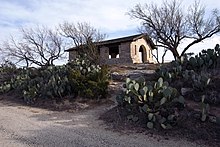
The area's "big spring", long dry but recently modified to draw water from Comanche Trail Lake, was of major importance to all life in the surrounding area. In the early 1840s, it was the center of a territorial dispute between Comanche and Pawnee tribes, and has been a major watering hole for wildlife and prehistoric people in this semiarid area.[15] Early military scouting reports and pioneer accounts describe the water as cold, clear, and dependable; the spring pool was about 15ft (5m) deep, with the overflow going only a short distance down the draw before it sank beneath the surface. The spring has mistakenly been described in other writings as being located in Sulphur Draw. It is actually located to the south, near the top of a small, rugged, unnamed draw running eastwards from the spring, and is itself a tributary to Beal's Creek, the name given to Sulphur Draw as it flows into, through, and past the city of Big Spring.
Long used by regional inhabitants, both permanent and nomadic, with a large number of locally collected artifacts testifying to its heavy occupation, the spring sat astride the several branches of the later-developed Comanche War Trail as they converged on this important water hole from beyond Texas, coming south across the Northern Plains and the Llano Estacado. From the Big Spring, the war trail continued south via three branches, one to the southeast through the western part of the Concho country; one going almost due south, heading for Castle Gap and Horsehead Crossing on the Pecos River; and one heading west to Willow Springs in the sand country southwest of present Midland, before turning south down the Pecos, all headed ultimately for Mexico. As whites began to settle the western territories, the spring continued to serve as a major watering place on the southern route of the Gold Rush Trail of the early 1850s and continued in use well beyond that time, as the cross-continental trail turned into a major road for later pioneers coming into the area.
The spring was sourced from a relatively small aquifer situated on the northern end of the Edwards Plateau and the southern end of the High Plains, being, structurally, a collecting sink of lower Cretaceous (Fredericksburg) limestones and sands.[15] The spring aquifer held a large quantity of water due to the great number of fractures, solution channels, and interstices in the rocks and underlying sands, although the areal extent of the Big Spring sink is estimated to be only 1mi (2km) in diameter, with the main area only 3,000ft (914m) wide and almost circular, with some ellipticity trending towards the west. The Cretaceous beds subsided about 280ft (85m) below their normal position, centered on the southeast quarter of Section 12, Block 33 T1S; T&P RR Co survey, and the entire stratum appears to be preserved within the sink, the surface topography roughly following the subsurface subsidence.[16] This writing identifies the sink as one of a number of similar subsurface geologic features in the surrounding area, differing from the Big Spring sink only in the fact that the surface topography above the others, while showing some decline, does not dip low enough to intersect the top of the water tables; hence, no springs could form from the other aquifers. In a passing comment, enigmatic in its content and disappointing in its brevity, the report states no other comparable deep sinks formed elsewhere on the Edwards Plateau.
The same publication suggests the spring's discharge volume was in excess of 100,000 U.S. gallons (378,541L) per day at the time of the railroad's arrival in the area in the late 1880s. The water was heavily mined by wells built by both the railroad and the early town of Big Spring, greatly in excess of its modest recharge rate, until the water table first dropped below the level of the spring outlet, and finally, was completely depleted by the mid-1920s. The city now artificially fills the spring from its current source of water as a means of allowing residents and visitors to maintain some idea of how it appeared in times past.
Geography
Big Spring is located slightly south of the center of Howard County in the valley of Beals Creek, an eastward-flowing tributary of the Colorado River. Interstate 20 runs through the northern side of the city, with access from exits 174 through 182. I-20 leads east 108 miles (174km) to Abilene and west 40 miles (64km) to Midland. U.S. Route 87 (Gregg Street) until recently ran through the center of Big Spring, leading north 106 miles (171km) to Lubbock and southeast 86 miles (138km) to San Angelo. A bypass to the west of the city now carries US 87, while the old route is now Business US 87.
According to the United States Census Bureau, Big Spring has a total area of 19.2 square miles (49.7km2). Approximately 19.1 square miles (49.5km2) are land, and 0.1 square miles (0.2km2), or 0.45%, is covered with water.[3]
Climate
Climate data for Big Spring, Texas (1991–2020 normals, extremes 1948–2021)
As of the 2020 United States census, 26,144 people, 8,458 households, and 5,127 families were residing in the city.
2010 census
As of the census[22] of 2010, 28,187 people,8,029 households, and 5,463 families resided in the city. The population density was 1,428.4 inhabitants per square mile (551.5/km2). The 9,865 housing units averaged 516.2 per square mile (199.3/km2). The racial makeup of the city was 76.69% White, 5.31% African American, 0.59% Native American, 0.63% Asian, 0.02% Pacific Islander, 14.41% from other races, and 2.35% from two or more races. Hispanics or Latinos of any race were 44.64% of the population.
Of the 8,155 households, 32.8% had children under 18 living with them, 48.3% were married couples living together, 14.1% had a female householder with no husband present, and 33.0% were not families. About 29.2% of all households were made up of individuals, and 14.6% had someone living alone who was 65 or older. The average household size was 2.51, and the average family size was 3.10.
In the city, the population was distributed as 23.6% under 18, 9.9% from 18 to 24, 32.7% from 25 to 44, 19.7% from 45 to 64, and 14.1% who were 65 or older. The median age was 35 years. For every 100 females, there were 125.2 males. For every 100 females age 18 and over, there were 132.3 males.
The median income for a household in the city was $28,257, and for a family was $35,448. Males had a median income of $27,636 versus $21,863 for females. The per capita income for the city was $14,119. About 17.1% of families and 22.2% of the population were below the poverty line, including 30.0% of those under age 18 and 18.3% of those age 65 or over.
Arts and culture
Big Spring is the site of several major hang-gliding championship tournaments, including the U.S. Hang Gliding Nationals.[23] The city was also the site for the filming of parts of Midnight Cowboy and Hangar 18.[24]
Big Spring Municipal Auditorium (a 1,400-seat, city-owned facility, which is home to the Big Spring Symphony and center for local and traveling performances[25])
Hangar 25 Air Museum (a museum, housed in a fully restored World War II-era hangar, which promotes education through the collection, preservation, and exhibition of the history of the Big Spring Army Air Force Bombardier School and Webb Air Force Base[27])
Comanche Trail Park (a 400-acre city park that features the historic "big spring", a 6,900-seat limestone amphitheater, an 18-hole golf course, tennis courts, baseball fields, playgrounds, and pavilions, as well as hike, bike and nature trails[28])
Moss Creek Lake (a 400-acre recreational area offering a beach swimming area, paintball course, dirt-bike course, and a playground, as well as an RV park with full hook-ups and 26 sheltered campsites[29])
Signal Peak (also called Signal Mountain, a landmark 10 miles southeast of Big Spring near Moss Creek Lake, used by Native Americans and early Anglo settlers[30])
George H. O'Brien, Jr. VA Medical Center (primary facility for the West Texas VA Health Care System, which serves veterans in 33 counties across 53,000 sq mi of West Texas and eastern New Mexico[31])
The Texas Department of State Health Services operates a 200-bed psychiatric hospital, opened in 1939. The hospital has reduced its number of beds over the years, but remains one of the largest employers in Big Spring.[citation needed]
The Colorado River Municipal Water District operates a reclaimed water treatment plant in Big Spring, the first of its kind in Texas, the product of which is then delivered to the potable water treatment plants of Big Spring, Stanton, Midland, and Odessa.[37][38][39]
Lefty Frizzell, American country music singer-songwriter and honky-tonk singer who led the house band for a local nightclub "Ace of Clubs" in the early 1950s
Young County is a county located in the U.S. state of Texas. As of the 2020 census, its population was 17,867. Its county seat is Graham. The county was created in 1856 and organized in 1874. It is named for William Cocke Young, an early Texas settler and soldier.
Throckmorton County is a county located in the U.S. state of Texas. As of the 2020 census, its population was 1,440. Its county seat is Throckmorton. The county was created in 1858 and later organized in 1879. It is named for William Throckmorton, an early Collin County settler. Throckmorton County is one of four remaining prohibition, or entirely dry, counties in Texas.
Swisher County is a county in the U.S. state of Texas. As of the 2020 census, its population was 6,971. Its county seat is Tulia. The county was created in 1876 and later organized in 1890. It is named for James G. Swisher, a soldier of the Texas Revolution and signer of the Texas Declaration of Independence.
Reagan County is a county on the Edwards Plateau in the U.S. state of Texas. As of the 2020 census, its population was 3,385. The county seat is Big Lake. The county is named after John Henninger Reagan (1818–1905), who was the postmaster general of the Confederate States and also a U.S. senator, U.S. representative, and first chairman of the Railroad Commission of Texas.
Pecos County is a county located in the U.S. state of Texas. As of the 2020 census, its population was 15,193. The county seat is Fort Stockton. The county was created in 1871 and organized in 1875. It is named for the Pecos River. It is one of the nine counties that comprise the Trans-Pecos region of West Texas.
Howard County is a county located in the U.S. state of Texas. At the 2020 census, its population was 34,860. Its county seat is Big Spring. The county was created in 1876 and organized in 1882. It is named for Volney E. Howard, a U.S. Congressman from Texas.
Dimmit County is a county located in the U.S. state of Texas. As of the 2020 census, its population was 8,615. The county seat is Carrizo Springs. The county was founded in 1858 and later organized in 1880. It is named after Philip Dimmitt, a major figure in the Texas Revolution. The spelling of the county name and the individual's name differ because of a spelling error in the bill creating the county name.
Comanche County is a county located on the Edwards Plateau in Central Texas. As of the 2020 census, its population was 13,594. The county seat is Comanche. The county was founded in 1856 and is named for the Comanche Native American tribe.
Brown County is a county in west-central Texas. As of the 2020 census, the population was 38,095. Its county seat is Brownwood. The county was founded in 1856 and organized in 1858. It is named for Henry Stevenson Brown, a commander at the Battle of Velasco, an early conflict between Texians and Mexicans.
Brewster County is a county located in the U.S. state of Texas. It is in West Texas and its county seat is Alpine. It is one of the nine counties that comprise the Trans-Pecos region, and borders Mexico. Brewster County is the largest county by area in the state - at 6,192 square miles (16,040 km2) it is over three times the size of the state of Delaware, and more than 500 square miles (1,300 km2) bigger than Connecticut.
Grady County is a county located in the U.S. state of Oklahoma. As of the 2020 census, the population was 54,795. Its county seat is Chickasha. It was named for Henry W. Grady, an editor of the Atlanta Constitution and southern orator.
Perry is a city in Houston and Peach counties in the U.S. state of Georgia. It is the county seat of Houston County. The population was 13,839 at the 2010 census, up from 9,602 at the 2000 census. As of 2019 the estimated population was 17,894. It is part of the Warner Robins, Georgia metropolitan statistical area, within the Macon–Bibb County–Warner Robins combined statistical area.
Belton is a city in the U.S. state of Texas. Belton is the county seat of Bell County and is the fifth largest city in the Killeen-Temple metropolitan area. In 2020, the population of Belton was 23,054, and the metro region had a population of 450,051 according to US Census estimates.
Brownwood is a city in and the county seat of Brown County, Texas, United States. The population was 18,862 as of the 2020 census. Brownwood is located in the Northern Texas Hill Country and is home to Howard Payne University, which was founded in 1889.
Comanche is a city located in Comanche County in the U.S. state of Texas. The population was 4,335 at the 2010 census. It is the county seat of Comanche County.
Lamesa is a city in and the county seat of Dawson County, Texas, United States. The population was 8,674 at the 2020 census, down from 9,952 at the 2000 census. Located south of Lubbock on the Llano Estacado, Lamesa was founded in 1903. Most of its economy is based on cotton farming. The Preston E. Smith prison unit, named for the former governor of Texas, is located just outside Lamesa.
Sulphur Springs is a city in and the county seat of Hopkins County, Texas, United States. As of the 2020 census, its population was 15,941. Sulphur Springs is located along the western edge of Northeast Texas.
Fort Stockton is a city in and the county seat of Pecos County, Texas, United States. It is located on Interstate 10, future Interstate 14, U.S. Highways 67, 285, and 385, and the Santa Fe Railroad, 329 mi (529 km) northwest of San Antonio and 240 mi (390 km) southeast of El Paso. Its population was 8,466 at the 2020 census.
Suamico is a village in Brown County in the U.S. state of Wisconsin. The population was 12,820 at the time of the 2020 census. Suamico is part of the Green Bay Metropolitan Statistical Area, and contains the neighborhood community of Flintville.
Big Spring State Park is a Texas state park in Big Spring, Howard County, Texas in the United States. It was opened in 1936 after the 381.99 acres (154.59 ha) upon which it is situated was deeded to the state by the city of Big Spring in 1934 and 1935. It is named for the natural spring once located on the site that was later replaced by an artificial one.
↑ Pickle, Joe (1980). Gettin' Started, Howard County's first 25 years. Big Springs [sic], Tex.: Heritage Museum. ISBN0-89015-268-3.
↑ Hill, R.T. 1890. "A brief description of the Cretaceous rocks of Texas and their economic value". In: Dumble, E.T. (ed.), First Annual Report of the Geological Survey of Texas, 1889. Austin: State Printing Office, pp. 105–141.
↑ Smith, Ralph A. (1985-1986), "The Comanches' Foreign War: Fighting Head Hunters in the Tropics," Great Plains Journal, Vol. 24-25, p. 21
↑ Marcy, R.B. 1850. "Report of Captain R.B. Marcy's route from Fort Smith to Santa Fe." In: Reports of the Secretary of War, Executive Document 64, Washington, D.C., pp. 169–233. (See p. 208)
↑ "Turbine timeline: The History of AWEA and the U.S. Wind Industry: 1990s." American Wind Energy Association. Retrieved 24 November 2015. AWEA website
1 2 Brune, G. 1981. Springs of Texas. Vol. I, Fort Worth: Branch Smith, p. 235
↑ Livingston, P.P.; Bennett, R.R. (1944). Geology and ground-water resources of the Big Spring area, Texas. Water Supply Paper 913. United States Geological Survey, 113 pp.
↑ Inc., Advanced Solutions International. "iMIS". www.ushpa.aero. Archived from the original on January 31, 2016. Retrieved April 4, 2018.{{cite web}}: |last= has generic name (help)
↑ "Hangar 18". March 13, 1981. Retrieved April 4, 2018– via www.imdb.com.
↑ Note: the US Census treats Hispanic/Latino as an ethnic category. This table excludes Latinos from the racial categories and assigns them to a separate category. Hispanics/Latinos can be of any race.[21]
This page is based on this Wikipedia article Text is available under the CC BY-SA 4.0 license; additional terms may apply. Images, videos and audio are available under their respective licenses.