Ariton, Alabama

Last updated

Ariton, Alabama
Dale County Alabama Incorporated and Unincorporated areas Ariton Highlighted 0102428.svg
Location of Ariton in Dale County, Alabama
Coordinates: 31°35′53″N85°43′7″W / 31.59806°N 85.71861°W / 31.59806; -85.71861
Country United States
State Alabama
County Dale
Area
[1]
  Total5.09 sq mi (13.18 km2)
  Land5.09 sq mi (13.18 km2)
  Water0.00 sq mi (0.00 km2)
Elevation
459 ft (140 m)
Population
 (2020)
  Total662
  Density130.06/sq mi (50.22/km2)
Time zone UTC-6 (Central (CST))
  Summer (DST) UTC-5 (CDT)
ZIP code
36311
Area code 334
FIPS code 01-02428
GNIS feature ID0151663

Ariton is a town in Dale County, Alabama, United States. At the 2020 census, the population was 662. It was incorporated in April 1906. [2] The name is a blend of its two predecessor town names: Ariosto and Charlton. [3]

Contents

Ariton is part of the Ozark Micropolitan Statistical Area.

Geography

Ariton is located in northwestern Dale County at 31°35′54″N85°43′8″W / 31.59833°N 85.71889°W / 31.59833; -85.71889 (31.598204, -85.718761). [4] Alabama State Routes 51 and 123 pass through the center of town as Main Street. AL 51 leads northeast 11 miles (18 km) to Clio and southwest 3.5 miles (5.6 km) to U.S. Route 231, while AL 123 leads west 3.5 miles (5.6 km) to US 231 and southeast 12 miles (19 km) to Ozark, the Dale County seat.

According to the U.S. Census Bureau, the town has a total area of 5.1 square miles (13.2 km2), all land. [5]

Demographics

Town of Ariton

Historical population
CensusPop.Note
1910 431
1920 62545.0%
1930 611−2.2%
1940 561−8.2%
1950 62010.5%
1960 68710.8%
1970 643−6.4%
1980 84431.3%
1990 743−12.0%
2000 7723.9%
2010 764−1.0%
2020 662−13.4%
U.S. Decennial Census [6]

Ariton first appeared on the 1910 U.S. Census as an incorporated town. [7]

2000 Census data

At the 2000 census there were 772 people, 306 households, and 220 families in the town. The population density was 152.3 inhabitants per square mile (58.8/km2). There were 335 housing units at an average density of 66.1 per square mile (25.5/km2). The racial makeup of the town was 69.30% White, 29.27% Black or African American, 0.13% Native American, and 1.30% from two or more races. 0.78%. [8] were Hispanic or Latino of any race.

Of the 306 households 39.2% had children under the age of 18 living with them, 47.1% were married couples living together, 20.6% had a female householder with no husband present, and 27.8% were non-families. 26.5% of households were one person and 15.7% were one person aged 65 or older. The average household size was 2.52 and the average family size was 3.02.

The age distribution was 28.5% under the age of 18, 8.4% from 18 to 24, 27.7% from 25 to 44, 18.4% from 45 to 64, and 17.0% 65 or older. The median age was 36 years. For every 100 females, there were 84.2 males. For every 100 females age 18 and over, there were 72.0 males.

The median household income was $21,083 and the median family income was $25,781. Males had a median income of $27,250 versus $17,639 for females. The per capita income for the town was $11,502. About 25.1% of families and 25.9% 55 of the population were below the poverty line, including 34.5% of those under age 18 and 22.2% of those age 65 or over.

2020 Census data

Ariton racial composition [9]
RaceNum.Perc.
White (non-Hispanic)43565.71%
Black or African American (non-Hispanic)13921.0%
Native American 10.15%
Asian 20.3%
Other/Mixed 263.93%
Hispanic or Latino 598.91%

As of the 2020 United States census, there were 662 people, 272 households, and 182 families residing in the town.

Historic Demographics

Census
Year
Population &
Racial
Majority [lower-alpha 1]
State
Place
Rank
County
Place
Rank
White
(White, Non-
Hispanic 1980-
BlackHispanic
(1980-
Native
American
AsianOther2 or More
Races
(2000-
1910 [lower-alpha 2] [7] 431 (-) [lower-alpha 3] [lower-alpha 4] 165th (-)5th (-)
1920 [10] 625 ↑153rd5th X [lower-alpha 5]
1930 [11] 611 ↓166th5th X
1940 [12] 561 ↓179th4th
1950 [13] 620 ↑216th4th X
1960 [14] 687 ↑216th [lower-alpha 6] X5th
1970 [15] 643 ↓255th7th
1980 [16] 844262nd7th X
1990 [17] 743 ↓290th7th X
2000 [lower-alpha 7] [18] 772 ↑309th7th X535 (-) 69.3% [lower-alpha 8] 226 (-) 29.3%6 (-) 0.8%1 (-) 0.1%10 (-) 1.3%
2010 [19] 764 ↓342nd8th56574%147 ↓ 19%466%10.1%70.9%111.4%

Ariton Census Division (1960-70)

Historical population
CensusPop.Note
1960 3,012
1970 3,1905.9%
U.S. Decennial Census [20]

Ariton Census Division was created in 1960 after the merger/reorganization of county precincts into census divisions. In 1980, it was consolidated into the Ozark Census Division.

Climate

The climate in this area is characterized by hot, humid summers and generally mild to cool winters. According to the Köppen Climate Classification system, Ariton has a humid subtropical climate, abbreviated "Cfa" on climate maps. [21]

Climate data for Ariton, Alabama
MonthJanFebMarAprMayJunJulAugSepOctNovDecYear
Mean daily maximum °C (°F)16
(61)
18
(64)
22
(71)
26
(79)
29
(85)
33
(91)
33
(91)
33
(91)
31
(88)
27
(80)
21
(70)
17
(62)
26
(78)
Mean daily minimum °C (°F)4
(39)
5
(41)
9
(48)
12
(54)
17
(62)
20
(68)
21
(70)
21
(70)
19
(66)
13
(56)
8
(46)
5
(41)
13
(55)
Average precipitation mm (inches)120
(4.6)
130
(5)
140
(5.7)
120
(4.6)
94
(3.7)
120
(4.6)
160
(6.3)
120
(4.9)
110
(4.3)
58
(2.3)
81
(3.2)
120
(4.9)
1,370
(54.1)
Source: Weatherbase [22]

Notable people

Related Research Articles

<span class="mw-page-title-main">Coffee County, Alabama</span> County in Alabama, United States

Coffee County is a county located in the southeastern part of the U.S. state of Alabama. As of the 2020 census, the population was 53,465. Its name is in honor of General John Coffee.

<span class="mw-page-title-main">Dale County, Alabama</span> County in Alabama, United States

Dale County is a county located in the southeastern part of the U.S. state of Alabama. As of the 2020 census the population was 49,326. Its county seat and largest city is Ozark. Its name is in honor of General Samuel Dale.

<span class="mw-page-title-main">Jackson County, Alabama</span> County in Alabama, United States

Jackson County is the northeasternmost county in the U.S. state of Alabama. As of the 2020 census, the population was 52,579. The county seat is Scottsboro. The county was named for Andrew Jackson, general in the United States Army and afterward President of the United States of America. Jackson County is a prohibition or dry county, but three cities within the county are "wet", allowing alcohol sales. Jackson County comprises the Scottsboro, AL Micropolitan Statistical Area, and Jackson county is included in the Scottsboro-Fort Payne combined statistical areas. It is the site of Russell Cave National Monument, an archeological site with evidence of 8,000 years of human occupation in the Southeast.

<span class="mw-page-title-main">Valley, Alabama</span> City in Alabama, United States

Valley is a city in Chambers County, Alabama, United States. Valley was incorporated in 1980 combining the four textile mill villages of Fairfax, Langdale, River View, and Shawmut. As of the 2010 census it had a population of 9,524. The city lies on the western bank of the Chattahoochee River, the state border between Alabama and Georgia. Valley is a pilot city for the Alabama Communities of Excellence program, a non-profit that partners with governments, businesses, and universities to prepare participating communities for a more vibrant future. It is included in the LaGrange, Georgia Micropolitan Statistical Area, which is included in the Greater Atlanta Combined Statistical Area.

<span class="mw-page-title-main">Ashland, Alabama</span> City in and county seat of Clay County, Alabama

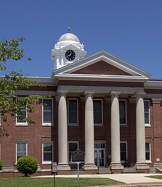
Ashland is a city in Clay County, Alabama, United States. The population was 2,037 at the 2010 census. The city is the county seat of Clay County.

<span class="mw-page-title-main">Arab, Alabama</span> City in Alabama, United States

Arab is a city in Marshall County in the northern part of the U.S. state of Alabama, located 10 miles (16 km) from Guntersville Lake and Guntersville Dam, and is included in the Huntsville-Decatur Combined Statistical Area. The population was 8,461 at the 2020 census.

<span class="mw-page-title-main">Clayhatchee, Alabama</span> Town in Alabama, United States

Clayhatchee is a town in Dale County, Alabama, United States. At the 2010 census the population was 589, up from 501 in 2000. It was incorporated in April 1967. It is part of the Ozark Micropolitan Statistical Area.

<span class="mw-page-title-main">North Courtland, Alabama</span> Town in Alabama, United States

North Courtland is a town in Lawrence County, Alabama, United States, and is included in the Decatur Metropolitan Area, as well as the Huntsville-Decatur Combined Statistical Area. It incorporated in 1981. At the 2010 census, the population of the town was 632, down from 799 in 2000. Along with Hillsboro, it is one of two majority black communities in Lawrence County out of its six populated communities as of 2010.

<span class="mw-page-title-main">Ardmore, Alabama</span> Town in Alabama, United States

Ardmore is a town in Limestone County, Alabama, United States, and is included in the Huntsville-Decatur Metro Area. The population was 1,321 at the 2020 census, It borders its sister city Ardmore, Tennessee.

<span class="mw-page-title-main">Athens, Alabama</span> City in and county seat of Limestone County, Alabama

Athens is a city in and the county seat of Limestone County, in the U.S. state of Alabama; it is included in the Huntsville-Decatur-Albertville, AL Combined Statistical Area. As of the 2020 census, the population of the city is 25,406.

<span class="mw-page-title-main">Ashville, Alabama</span> City in and county seat of St. Clair County, Alabama

Ashville is a city in and one of the county seats of St. Clair County, Alabama, United States, other seat being Pell City. Its population was 2,212 at the 2010 census, down from 2,260, at which time it was a town. It incorporated in 1822.

Hackberry is an unincorporated community and census-designated place (CDP) in Cameron Parish, Louisiana, United States. The population was 1,261 at the 2010 census, down from 1,699 in 2000. The losses were due to extensive damage from hurricanes Rita and Ike in 2005 and 2008, respectively. It is part of the Lake Charles Metropolitan Statistical Area.

<span class="mw-page-title-main">Derry Township, Dauphin County, Pennsylvania</span> Township in Pennsylvania, United States

Derry Township is a township in Dauphin County, Pennsylvania, United States. The population was 24,796 at the 2020 census, an increase over the figure of 24,679 tabulated in 2010. Hershey, the site of the well-known Hershey's chocolate factory and its affiliated amusement park, is located within the township. Pennsylvania State University's Milton S. Hershey Medical Center and the Penn State Hershey Children's Hospital are also located on a large tract of land in the township.

<span class="mw-page-title-main">German Township, Fayette County, Pennsylvania</span> Township in Pennsylvania, United States

German Township is a township in Fayette County, Pennsylvania, United States. The population was 4,672 at the 2020 census, a decline from the figure of 5,097 tabulated in 2010. McClellandtown is the township's largest village. The Albert Gallatin Area School District serves the region.

<span class="mw-page-title-main">Redstone Township, Pennsylvania</span> Township in Pennsylvania, United States

Redstone Township is a township in Fayette County, Pennsylvania, United States. The population was 5,077 at the 2020 census, a decline from the figure of 5,566 tabulated in 2010. The Brownsville Area School District serves the region.

Arguta is an unincorporated community in Dale County, Alabama, United States.

<span class="mw-page-title-main">Abbot Springs, Alabama</span> Unincorporated community in Alabama, United States

Abbot Springs is a settlement in Shelby County, Alabama, United States. While the community was once unincorporated, it is now part of eastern Westover. It lies less than 3 miles away from the town of Harpersville. It runs along a branch of Old Highway 280.

Argo is an unincorporated community in Walker County, Alabama, United States. Argo is located on U.S. Route 78, 4.7 miles (7.6 km) northwest of Sumiton.

<span class="mw-page-title-main">Alabama City, Alabama</span> Former City in Alabama, United States

Alabama City is a former city and now a neighborhood within the city of Gadsden in Etowah County, Alabama, United States. It was equidistant between Gadsden and Attalla, Alabama, approximately 2 1/2 miles west of downtown Gadsden.

Austinville is a former town and now a neighborhood within the city of Decatur in Morgan County, Alabama, United States. It is about 3 miles south from downtown Decatur, centered on the junction of Danville Road and Carridale Street. It was incorporated as a town in 1907 and disincorporated and annexed into the city of Decatur in 1956.

References

Notes

  1. Note about colors: With the exception of Hispanic, Pacific Islander, Other, and 2 or More Races, the colors depicted refer to those historically ascribed to them (White (White/No background); Black (Brown); Native American (Red); Asian (Yellow)) and are there to be easily identified on said chart. No racism or malice of intent is meant to be implied by their usage.
  2. 1st year Ariton reported on census
  3. (-)Indicates no immediate prior population figure or rank
  4. Racial demographics not reported for places of less than 2,500 on 1910-20 censuses or for less than 1,000 on the 1930-90 censuses.
  5. X Indicates no change in rank
  6. Tied for 216th place with Cedar Bluff
  7. With addition of "Hispanic" to census, which could also be a person of any race, both population totals and percentages will add up to more than the total population.
  8. From 2000 onwards, White population only reported on chart as "Non-Hispanic White/One Race", which will be less than the overall White population that would also include White Hispanics, which would be counted under Hispanic exclusively.

References

  1. "2020 U.S. Gazetteer Files". United States Census Bureau. Retrieved October 29, 2021.
  2. "Ariton". Encyclopedia of Alabama. Retrieved December 5, 2020.
  3. Foscue, Virginia O. (1989). Place Names in Alabama. University of Alabama Press. ISBN   9780817304102.
  4. "US Gazetteer files: 2010, 2000, and 1990". United States Census Bureau. February 12, 2011. Retrieved April 23, 2011.
  5. "Geographic Identifiers: 2010 Demographic Profile Data (G001): Ariton town, Alabama". U.S. Census Bureau, American Factfinder. Retrieved October 2, 2015.[ dead link ]
  6. "U.S. Decennial Census". Census.gov. Retrieved June 6, 2013.
  7. 1 2 http://www2.census.gov/prod2/decennial/documents/41033935v1-8ch1.pdf, 1910 AL Census
  8. "U.S. Census website". United States Census Bureau . Retrieved January 31, 2008.
  9. "Explore Census Data". data.census.gov. Retrieved December 17, 2021.
  10. http://www2.census.gov/prod2/decennial/documents/06229686v1-7ch01.pdf, 1920 AL Census
  11. http://www2.census.gov/prod2/decennial/documents/03815512v1ch02.pdf, 1930 AL Census
  12. http://www2.census.gov/prod2/decennial/documents/33973538v1ch03.pdf, 1940 AL Census
  13. http://www2.census.gov/prod2/decennial/documents/23761117v1ch04.pdf, 1950 AL Census
  14. http://www2.census.gov/prod2/decennial/documents/37721510v1p2ch2.pdf, 1960 AL Census
  15. http://www2.census.gov/prod2/decennial/documents/1970a_al-01.pdf, 1970 AL Census
  16. http://www2.census.gov/prod2/decennial/documents/1980a_alABC-01.pdf, 1980 AL Census
  17. http://www.census.gov/prod/cen1990/cph5/cph-5-2.pdf, 1990 AL Census
  18. http://www.census.gov/prod/cen2000/phc-1-2.pdf, 2000 AL Census
  19. http://www.census.gov/prod/cen2010/cph-1-2.pdf, 2010 AL Census
  20. "U.S. Decennial Census". Census.gov. Retrieved June 6, 2013.
  21. Climate Summary for Ariton, Alabama
  22. "Weatherbase.com". Weatherbase. 2013. Retrieved on November 3, 2013.
  23. Big Mama Thornton: The Life and Music. McFarland Inc. ISBN   978-0-7864-7759-3

31°35′54″N85°43′08″W / 31.598204°N 85.718761°W / 31.598204; -85.718761