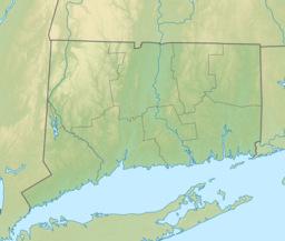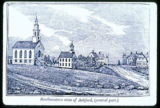
Ashford is a town in Windham County, Connecticut, United States. It is part of the Connecticut Quiet Corner. The population was 4,191 at the 2020 census. It was founded in 1714. Eastford was a part of Ashford until 1847, when the former split off to organize its own town. For this reason North Ashford is located in northeast Eastford.
Lake Attitash is a lake located on the border of Merrimac, Massachusetts and Amesbury, Massachusetts, and constitutes at least a portion of Amesbury's water supply.

Long Pond is a 1,721-acre (7.0 km2) lake within the towns of Lakeville and Freetown, in southeastern Massachusetts. It shares its waters with Assawompset Pond. These lakes provide a source of drinking water to the city of New Bedford, the largest city in southeastern Massachusetts. Long Pond is roughly one mile (1.6 km) wide by four miles (6.4 km) miles long, and contains three islands within its boundaries. In 1894 Assawompset Pond was dammed, increasing the water depth of Long Pond by about five feet (1.5 m). This created Nelson Island and caused Sunken Island to disappear due to erosion. All that remains of Sunken Island are the rocks in a shallow area just to the northwest of Lewis Island. Lewis Island is the largest of the three remaining islands today, containing sixteen privately owned cottages, while the second largest island, Nelson Island, was purchased in 2005 and now is a year-round private residence. The smallest island, Goat Island, was recently purchased from the Boy Scouts by a private citizen. Along the perimeter of the lake are many homes and private access points to the waterfront. Long Pond is well known for fishing and boating.
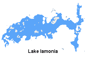
Lake Iamonia ⟨aɪ ˈmoʊ njə⟩ is a large, subtropical prairie lake in northern Leon County, Florida, United States, created during the Pleistocene epoch.

Goose Pond is a 625-acre (2.5 km2) water body located in Grafton County in western New Hampshire, United States, in the towns of Canaan and Hanover. It is considered a great pond by the state of New Hampshire. The lake has 6.3 miles (10.1 km) of shoreline, and is approximately 3 miles (5 km) long by 0.5 miles (0.8 km) wide. All but the northernmost end of the pond is in the town of Canaan. The average depth of the pond is approximately 10 feet (3.0 m), with the deepest part approximately 35 feet (11 m). The lake is part of the Mascoma River watershed, flowing to the Connecticut River.

Flagstaff Lake is located in Somerset County and Franklin County, Maine in the United States. The North Branch Dead River and South Branch Dead River join in the lake, forming the Dead River.

Brooks Pond is a Massachusetts water body that is privately owned, controlled and managed, and bordered by the towns of North Brookfield, Oakham, Spencer, and New Braintree. It forms the headwaters of the Five Mile River, which is part of the Chicopee River Watershed.

Ninemile Creek, also known as Nine Mile Creek, is a stream in Central New York in the United States. Its source is at Otisco Lake in the town of Marcellus, from where the creek runs northward for 21.75 miles (35.00 km) through the villages of Marcellus and Camillus to Onondaga Lake in the town of Geddes. Nine Mile Creek is a scenic stream noted for trout fishing.
The Mount Hope River is a river in northeastern section of the U.S. state of Connecticut. The river is formed at the outlet of Morey Pond at the extreme northern end of Ashford, Connecticut, at the border of Union, Connecticut, and flows about 15 miles (24 km) south to Mansfield Hollow Lake, just south of Mansfield, Connecticut.
Fresh Pond is a 62-acre (250,000 m2) pond in the Manomet section of Plymouth, Massachusetts. The average depth is 12 feet (3.7 m) and the maximum depth is 30 feet (9.1 m). The southern shore of the pond is located in the Churchill Landing neighborhood, south of Manomet's business district and Manomet Bluffs, west of Fisherman's Landing, north of Cedar Bushes and Shallow Pond, and east of Beaver Dam Pond. Route 3A runs along the southeastern shore of the pond to its most southeastern point where it shoots away at a sharp curve known as the Brown Bear Curve, named after a defunct motel along the shore at that curve. A public beach, boat ramp, and a Native American burial site are located on the western shore of the pond on Bartlett Road, which has two intersections with Route 3A. The closer intersection is south of the Brown Bear Curve, while the other intersection is one mile (1.6 km) north, north of Manomet's business district. The pond is hydrologically associated with a cranberry bog operation located to the west of the pond. An unnamed brook heads west through the cranberry bog and ultimately leading to Beaver Dam Brook is the outflow of the pond.

Winnecunnet Pond or Winneconnet Pond or Winnecunnett Pond, very often called Lake Winnecunnet or Lake Winneconnet or Lake Winnecunnett although it is a pond rather than a lake, is a body of water in Norton, Massachusetts, United States.

Lake Waramaug is a 656-acre (265 ha) lake occupying parts of the towns of Kent, Warren and Washington in Litchfield County, Connecticut, approximately 24 miles (39 km) north of Danbury. The lake is named after Chief Waramaug, who wintered in the area surrounding Lake Waramaug.

The Watuppa Ponds are two large, naturally occurring, spring-fed, glacially formed ponds located in Fall River and Westport, Massachusetts. Watuppa is a native word meaning "place of boats". The two ponds were originally one body of water, connected by a narrow rocky straight called "The Narrows" located on a thin strip of land between the two ponds which forms part boundary of between Fall River and Westport. The border between Fall River and Westport is also divided between the two ponds. Together, the ponds have an overall north–south length of about 7.5 miles, and have an average east–west width of about a mile. The ponds are drained by the Quequechan River, and flows in a westerly direction through the center of Fall River from South Watuppa Pond to Mount Hope Bay.

Lake Sunapee is located within Sullivan County and Merrimack County in western New Hampshire, the United States. It is the fifth-largest lake located entirely in New Hampshire.
Gull Lake is a lake in the U.S. state of Minnesota, located in Cass County and Crow Wing County. It is one of the largest lakes in the Brainerd, Minnesota-Baxter, Minnesota area and also one of the most popular for vacationing and for recreation. Of the seven Gull Lakes in Minnesota, this Gull Lake is the largest in area and shoreline. The shoreline is highly developed with residential and commercial interests. For each shoreline mile there are 27.8 homes or cabins. There are 19 resorts on Gull Lake, including notably Cragun's, Madden's, and Grand View Lodge.
Lake Gleneida is a controlled lake in the hamlet of Carmel within the Town of Carmel in central Putnam County, New York. Originally a smaller natural water body, Shaw's Pond, it was dammed by New York City in 1870 and enlarged to 168 acres (68 ha) for inclusion in its water supply system. It is part of the New York City water system's Croton Watershed.
Mashapaug Lake is a 297-acre (1.20 km2) lake surrounded by Bigelow Hollow State Park and Nipmuck State Forest in the town of Union in northeastern Connecticut. The lake has a maximum depth of 39.5 feet, and an average depth of 15 feet. Its normal surface elevation is 706 feet. The lake is very popular with fishermen and boaters from the area, and can also be used for swimming.
Hidden Lake is one of five villages located within the town of Haddam, Connecticut. It is governed by the bylaws of the Hidden Lake Association.
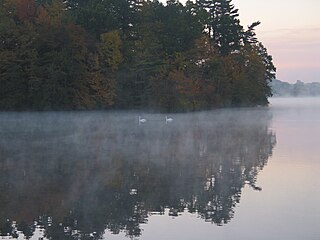
Lake Chaffee is a small, shallow, man-made lake located approximately 2 miles (3.2 km) northwest of the hamlet of Westford in the town of Ashford in Windham County, northeastern Connecticut. The lake has an area of 54 acres (22 ha) and a maximum depth of 11 feet (3.4 m). Its average surface elevation is 856 feet (261 m) above sea level.

Moore Dam is a major hydroelectric dam on the Upper Connecticut River between Grafton County, New Hampshire and Caledonia County, Vermont in the northeastern United States. The dam is located near Littleton, New Hampshire, and forms the 3,490-acre (1,410 ha) Moore Reservoir. The Moore Station is the largest conventional hydroelectric plant in New England, in terms of installed capacity and average power generation. The dam and reservoir also provide flood control, recreational boating and fishing.