Averill, Vermont

Last updated

Averill, Vermont
Essex County Vermont incorporated and unincorporated areas Averill highlighted.svg
Location in Essex County and the state of Vermont.
Map of USA VT.svg
Location of Vermont with the U.S.A.
Country United States
State Vermont
County Essex County
Government
  TypeUnincorporated town
Area
  Total38.1 sq mi (98.6 km2)
  Land36.0 sq mi (93.3 km2)
  Water2.0 sq mi (5.3 km2)
Elevation
1,697 ft (517 m)
Population
 (2020)
  Total21
  Density0.5/sq mi (0.2/km2)
Time zone UTC-5 (EST)
  Summer (DST) UTC-4 (EDT)
ZIP code
05901
FIPS code 50-009-02125
GNIS feature ID1462029

Averill is an unincorporated town in Essex County, Vermont, United States. The town was named for Samuel Averill, a landholder. [1] The town was never formally incorporated, having never gained a large enough permanent population. The population was 21 at the 2020 census. [2] The town's affairs are handled by the Unified Towns & Gores of Essex County. It is part of the Berlin, New Hampshire Vermont Micropolitan Statistical Area.

Contents

History

Averill was originally chartered in 1762 as part of the Province of New Hampshire on the behalf of Royal Governor Benning Wentworth. Averill consisted of twenty three thousand and forty acres of land, which was divided among seventy equal shares, with the stipulation that the grantees must cultivate a tenth of their land within five years, and that all pine trees fit for ship masts must be preserved for that purpose. [3] The first settlers arrived in the 1830s, and in 1840 the town had 11 residents. In the 1870s a sawmill was built in the neighboring town of Norton, which led to a rise in population to 48 residents in 1880. [4] The Averill Lumber Co. formed in the 1880s, and operated a mill on the east side of Great Averill Lake until it burned down in 1898. [5]

Geography

Averill is in northern Essex County, bordered by Canaan to the northeast, Lemington to the southeast, Bloomfield at the southernmost point, Lewis on the southwest, Averys Gore to the west, and Norton to the northwest. The northern corner of Averill is less than 0.5 miles (0.8 km) south of the Canada–US border.

Vermont Route 114 crosses the northern tip of the town, leading east 8 miles (13 km) to Canaan village and west 5 miles (8 km) to Norton. According to the United States Census Bureau, the town has a total area of 38.1 square miles (98.6 km2), of which 36.0 square miles (93.3 km2) is land and 2.0 square miles (5.3 km2), or 5.40%, is water. [6] The town includes Great Averill Pond, Little Averill Pond, and Forest Lake. The highest point in the town is an unnamed 2,970-foot (910 m) summit along the border with Lemington in the southeast.

Climate

The Averill weather station is near the northern edge of Great Averill Pond, just south of the border with Canada. Averill has a humid continental climate(Köppen Dfb), with subarctic climate (Köppen Dfc) influences. Its far northern location and relatively high elevation of 1,699 ft (518 m), means it has some of the coldest weather in Vermont. The daily average temperature stays below freezing for five months, with high levels of snowfall as well. The climate is very similar to the nearby places Island Pond and First Connecticut Lake.

This weather box uses the temperature and precipitation normals for Averill.

Climate data for Averill, Vermont, 1991–2020 normals, 2011–2023 extremes: 1699ft (518m)
MonthJanFebMarAprMayJunJulAugSepOctNovDecYear
Record high °F (°C)51
(11)
64
(18)
76
(24)
80
(27)
92
(33)
89
(32)
90
(32)
87
(31)
88
(31)
83
(28)
70
(21)
59
(15)
92
(33)
Mean maximum °F (°C)43.5
(6.4)
46.8
(8.2)
54.3
(12.4)
68.4
(20.2)
83.3
(28.5)
85.3
(29.6)
86.6
(30.3)
83.9
(28.8)
81.9
(27.7)
73.0
(22.8)
61.7
(16.5)
49.0
(9.4)
85.9
(29.9)
Mean daily maximum °F (°C)21.5
(−5.8)
24.9
(−3.9)
34.0
(1.1)
47.2
(8.4)
62.2
(16.8)
70.3
(21.3)
75.5
(24.2)
73.9
(23.3)
66.4
(19.1)
53.4
(11.9)
39.6
(4.2)
28.2
(−2.1)
49.8
(9.9)
Daily mean °F (°C)10.9
(−11.7)
13.6
(−10.2)
22.8
(−5.1)
36.9
(2.7)
50.7
(10.4)
59.3
(15.2)
64.4
(18.0)
62.6
(17.0)
55.1
(12.8)
43.1
(6.2)
31.1
(−0.5)
19.4
(−7.0)
39.2
(4.0)
Mean daily minimum °F (°C)0.2
(−17.7)
2.2
(−16.6)
11.5
(−11.4)
26.6
(−3.0)
39.1
(3.9)
48.3
(9.1)
53.2
(11.8)
51.2
(10.7)
43.7
(6.5)
32.7
(0.4)
22.6
(−5.2)
10.6
(−11.9)
28.5
(−1.9)
Mean minimum °F (°C)−20.3
(−29.1)
−21.0
(−29.4)
−13.3
(−25.2)
10.0
(−12.2)
24.6
(−4.1)
32.3
(0.2)
39.3
(4.1)
38.3
(3.5)
28.5
(−1.9)
19.5
(−6.9)
−0.3
(−17.9)
−12.6
(−24.8)
−25.1
(−31.7)
Record low °F (°C)−30
(−34)
−32
(−36)
−25
(−32)
1
(−17)
21
(−6)
28
(−2)
35
(2)
35
(2)
23
(−5)
11
(−12)
−10
(−23)
−29
(−34)
−32
(−36)
Average precipitation inches (mm)2.57
(65)
2.51
(64)
3.31
(84)
2.93
(74)
4.00
(102)
4.65
(118)
4.12
(105)
4.33
(110)
3.75
(95)
4.46
(113)
3.26
(83)
2.89
(73)
42.78
(1,086)
Average snowfall inches (cm)33.5
(85)
34.0
(86)
29.2
(74)
10.9
(28)
2.0
(5.1)
0.0
(0.0)
0.0
(0.0)
0.0
(0.0)
0.0
(0.0)
2.3
(5.8)
20.8
(53)
32.1
(82)
164.8
(418.9)
Source 1: NOAA [7]
Source 2: XMACIS (extremes & 2012-2020 snowfall) [8]

Government

Averill, along with the unorganized towns of Lewis and Ferdinand, as well as the unincorporated areas of Avery's Gore, Warren's Gore, and Warner's Grant, had no local governance. In 2000, a representative Board of Governors (three members) was elected to replace the former Essex County Supervisor system.

Demographics

Historical population
CensusPop.Note
1830 1
1840 111,000.0%
1850 7−36.4%
1860 1271.4%
1870 1416.7%
1880 48242.9%
1890 43−10.4%
1900 18−58.1%
1910 15−16.7%
1920 4−73.3%
1930 9125.0%
1940 1233.3%
1950 2066.7%
1960 16−20.0%
1970 8−50.0%
1980 1587.5%
1990 7−53.3%
2000 814.3%
2010 24200.0%
2020 21−12.5%
U.S. Decennial Census [9]

As of the census [10] of 2000, there were 8 people, 3 households, and 2 families residing in the town. The population density was 0.2 inhabitants per square mile (0.1/km2). There were 192 housing units at an average density of 5.3 per square mile (2.0/km2). The census also indicates that the racial makeup of the town was 100.00% White, and that 11.1% of the population spoke French at home due largely to the town's proximity to the Province of Quebec.

There were 3 households, out of which one had children under the age of 18 living with them, two were married couples living together, and one was a non-family. One household was made up of individuals who were 65 years of age or older. The average household size was 2.67 and the average family size was 3.50.

In the town, the population was spread out, with two people under the age of 18, one from 18 to 24, two from 25 to 44, one from 45 to 64, and two people who were 65 years of age or older. The median age was 42 years. There were three males and five females, out of which two were under the age of 18.

The median income for a household in the town was $27,500, and the median income for a family was $28,750. Males had a median income of $21,250 versus $13,750 for females. The per capita income for the town was $9,876. None of the population or families were below the poverty line.

Averill contains two lakes—Big Averill Lake (sometimes notated on maps as Great Averill pond) and Little Averill Lake. Big Averill is a relatively large, rectangular lake about 2 miles long and 0.7 miles wide. One side of the lake (Cottage Road) is outfitted with electrical power, and the backside (Jackson Road) is not wired for electricity. Little Averill lies 1,000 yards to the southwest of Big Averill. [11]

Related Research Articles

<span class="mw-page-title-main">Essex County, Vermont</span> County in Vermont, United States

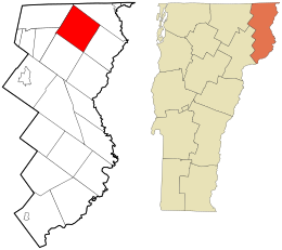
Essex County is a county located in the northeastern part of the U.S. state of Vermont. As of the 2020 census, the population was 5,920, making it the least-populous county in both Vermont and New England. Its shire town is the municipality of Guildhall. The county was created in 1792 and organized in 1800. Bordered by the Connecticut River next to New Hampshire, Essex County is south of the Canadian province of Quebec. It is the county with the lowest household-income in Vermont.

<span class="mw-page-title-main">Chesterfield, New York</span> Town in New York, United States

Chesterfield is a town in Essex County, New York, United States. The population was 2,445 at the 2010 census. The name possibly is from a location in New England.

<span class="mw-page-title-main">Crown Point, New York</span> Town in New York, United States

Crown Point is a town in Essex County, New York, United States, located on the west shore of Lake Champlain. The population was 2,024 at the 2010 census. The name of the town is a direct translation of the original French name, Pointe à la Chevelure.

<span class="mw-page-title-main">Elizabethtown, New York</span> Town in New York, United States

Elizabethtown is a town in Essex County, New York, United States. The population was 1,163 at the 2010 census. The county seat of Essex County is the hamlet of Elizabethtown, located in the northern part of the town. The name is derived from Elizabeth Gilliland, the wife of an early settler.

<span class="mw-page-title-main">Minerva, New York</span> Town in New York, United States

Minerva is a town in Essex County, New York, United States. The population was 773 at the 2020 census. The town is named after Minerva, the Roman goddess of wisdom. The town has a highly irregular polygonal shape. It is located in the southwestern corner of the county. By road, it is 40 miles (64 km) north-northwest of Queensbury, 85 miles (137 km) southwest of Burlington, Vermont, 88 miles (142 km) south of Plattsburgh, 93 miles (150 km) north of Albany, and 147 miles (237 km) south of Montreal, Quebec.

<span class="mw-page-title-main">Moriah, New York</span> Town in New York, United States

Moriah is a town in Essex County, New York, United States. Lying within the Adirondack Park, it is situated in the eastern part of the county, 47 miles (76 km) by road south-southwest of Burlington, Vermont, 55 miles (89 km) south of Plattsburgh, 115 miles (185 km) north of Albany, and 116 miles (187 km) south of Montreal, Quebec. The population was 4,798 at the 2010 census.

<span class="mw-page-title-main">Newcomb, New York</span> Town in New York, United States

Newcomb is a town in Essex County, New York, United States. The population was 436 at the 2010 census.

<span class="mw-page-title-main">Johnsburg, New York</span> Town in New York, United States

Johnsburg is a town in the northwestern corner of Warren County, New York, United States. It is part of the Glens Falls Metropolitan Statistical Area. The town population was 2,143 at the 2020 census. The town is named after John Thurman, an early settler and founder. Johnsburg is the largest town in Warren County by area.

<span class="mw-page-title-main">Putnam, New York</span> Town in Washington County, New York, US

Putnam is a town in northern Washington County, New York, United States. It is part of the Glens Falls Metropolitan Statistical Area. The town population was 645 at the 2000 census. The town is named after Israel Putnam, a hero of the American Revolution.

<span class="mw-page-title-main">Bloomfield, Vermont</span> Town in Vermont, United States

Bloomfield is a town in Essex County, Vermont, United States. The population was 217 at the 2020 census. It is part of the Berlin, New Hampshire-Vermont Micropolitan Statistical Area.

<span class="mw-page-title-main">Brighton, Vermont</span> Town in Vermont, United States

Brighton is a town in Essex County, Vermont, United States. The population was 1,157 at the 2020 census. The town was named "Gilead" in its original grant in 1780. The town was sold to a group consisting primarily of soldiers commanded by Colonel Joseph Nightingale and subsequently named "Random". The town's name was finally changed by the legislature to "Brighton" in 1832. The Brighton village of Island Pond gets its name from the Abenaki word Menanbawk, which literally means island pond.

<span class="mw-page-title-main">Concord, Vermont</span> Town in Vermont, United States

Concord is a town in Essex County, Vermont, United States. The population was 1,141 at the 2020 census. It is part of the Berlin, NH –VT Micropolitan Statistical Area.

<span class="mw-page-title-main">Ferdinand, Vermont</span> Town in Vermont, United States

Ferdinand is a town in Essex County, Vermont, United States. It was named after German Prince Karl Wilhelm Ferdinand of Brunswick-Lunenburg. Although incorporated, it was never formally organized since it never gained a sufficiently large permanent population. Its population was 16 at the 2020 census and was highest in 1910, with 213. It is managed by the Unified Towns & Gores of Essex County. It is part of the Berlin, NH –VT Micropolitan Statistical Area.

<span class="mw-page-title-main">Lemington, Vermont</span> Town in Vermont, United States

Lemington is a town in Essex County, Vermont, United States. The population was 87 as of the 2020 census. It is part of the Berlin, NH –VT Micropolitan Statistical Area.

<span class="mw-page-title-main">Lunenburg, Vermont</span> Town in Vermont, United States

Lunenburg is a town in Essex County, Vermont, United States. The population was 1,246 at the 2020 census, the most populous in Essex County. Lunenburg contains the villages of Lunenburg and Gilman and hamlets of West Lunenburg, South Lunenburg, and Mill Village, and is part of the Berlin, NH –VT Micropolitan Statistical Area.

<span class="mw-page-title-main">Maidstone, Vermont</span> Town in Vermont, United States

Maidstone is a town in Essex County, Vermont, United States. As of the 2020 census, the town had a population of 211. It is part of the Berlin, NH –VT Micropolitan Statistical Area. There is no town center or gas station, but there is a town office building in the southern part of the town.

<span class="mw-page-title-main">Norton, Vermont</span> Town in Vermont, United States

Norton is a town in Essex County, Vermont, United States. The population was 153 at the 2020 census. It is part of the Berlin, NH –VT Micropolitan Statistical Area. It is located on the Canada–US border, immediately south of Stanhope, Quebec.

<span class="mw-page-title-main">Warren's Gore, Vermont</span> Place in the United States

Warren's Gore is a gore in Essex County, Vermont, United States. The population was 2 at the 2020 census, down from 4 at the 2010 census. In Vermont, gores and grants are unincorporated portions of a county which are not part of any town and have limited self-government. Warren's Gore is part of the Berlin, NH–VT Micropolitan Statistical Area.

<span class="mw-page-title-main">Elmore, Vermont</span> Town in Vermont, United States

Elmore is a town in Lamoille County, Vermont, United States. It was granted by the Vermont Republic in 1780, and was named for Colonel Samuel Elmore (1720–1805), one of the original grantees. The population was 886 at the 2020 census. Elmore contains the villages of East Elmore and Lake Elmore, as well as Elmore State Park, a 700-acre (2.8 km2) recreational area on the 219-acre (0.9 km2) Lake Elmore and on Elmore Mountain to the west.

<span class="mw-page-title-main">Albany, Vermont</span> Town in Vermont, United States

Albany is a town in Orleans County, Vermont, United States. The population was 976 at the 2020 census. Albany contains four villages: the incorporated village of Albany, and the unincorporated villages of Albany Center, East Albany and South Albany.

References

  1. "Profile for Averill, Vermont". ePodunk . Retrieved May 9, 2010.
  2. "Census - Geography Profile: Averill town, Essex County, Vermont". United States Census Bureau . Retrieved December 27, 2021.
  3. Bouton, Nathaniel (1895). Provincial and State Papers, Volume 26. Concord. p. 16.
  4. Andrews, Lydia (1986). Three Towns: (Averill, Norton, Stanhope). p. 160.
  5. Andrews, Lydia (1986). Three Towns: (Averill, Norton, Stanhope). p. 161.
  6. "Geographic Identifiers: 2010 Census Summary File 1 (G001): Averill town, Essex County, Vermont". American Factfinder. U.S. Census Bureau. Archived from the original on February 13, 2020. Retrieved March 31, 2016.
  7. "Averill, Vermont 1991-2020 Monthly Normals" . Retrieved October 20, 2023.
  8. "xmACIS". National Oceanic and Atmospheric Administration. Retrieved October 22, 2023.
  9. "U.S. Decennial Census". United States Census Bureau. Retrieved May 16, 2015.
  10. "U.S. Census website". United States Census Bureau . Retrieved January 31, 2008.
  11. "Welcome to DEC - Department of Environmental Conservation" (PDF). www.anr.state.vt.us.

44°56′22″N71°39′59″W / 44.93944°N 71.66639°W / 44.93944; -71.66639