Avon, South Dakota

Last updated

Avon, South Dakota
Avon SD Main Street.JPG
Main St. in Avon.
Bon Homme County South Dakota Incorporated and Unincorporated areas Avon Highlighted.svg
Location in Bon Homme County and the state of South Dakota
Coordinates: 43°00′19″N98°03′33″W / 43.00528°N 98.05917°W / 43.00528; -98.05917
Country United States
State South Dakota
County Bon Homme
Established1879 [1]
Area
[2]
  Total0.65 sq mi (1.68 km2)
  Land0.65 sq mi (1.68 km2)
  Water0.00 sq mi (0.00 km2)
Elevation
[3]
1,618 ft (493 m)
Population
 (2020) [4]
  Total586
  Density904.32/sq mi (349.13/km2)
Time zone UTC-6 (Central (CST))
  Summer (DST) UTC-5 (CDT)
ZIP code
57315
Area code 605
FIPS code 46-02900
GNIS feature ID1267274 [3]
Website cityofavon.org

Avon is a city in Bon Homme County, South Dakota, United States. The population was 586 at the 2020 census. [5]

Contents

History

Avon was founded in 1879. The community owes its name to Avon, New York, the hometown of an early postmaster. [6] Construction of the railroad prompted the town to move to its current site in 1900. [7]

Geography

Avon is served by South Dakota Highway 50, which runs east-west in the northern part of town.

According to the United States Census Bureau, the city has a total area of 0.64 square miles (1.66 km2), all land. [8]

Demographics

Historical population
CensusPop.Note
1910 451
1920 63039.7%
1930 6706.3%
1940 7288.7%
1950 692−4.9%
1960 637−7.9%
1970 610−4.2%
1980 576−5.6%
1990 5760.0%
2000 561−2.6%
2010 5905.2%
2020 586−0.7%
U.S. Decennial Census [9] [4]

2010 census

As of the census [10] of 2010, there were 590 people, 256 households, and 152 families residing in the city. The population density was 921.9 inhabitants per square mile (355.9/km2). There were 313 housing units at an average density of 489.1 per square mile (188.8/km2). The racial makeup of the city was 94.1% White, 3.1% Native American, 0.2% Asian, 1.0% from other races, and 1.7% from two or more races. Hispanic or Latino of any race were 2.0% of the population.

There were 256 households, of which 28.5% had children under the age of 18 living with them, 52.0% were married couples living together, 5.9% had a female householder with no husband present, 1.6% had a male householder with no wife present, and 40.6% were non-families. 37.9% of all households were made up of individuals, and 22.6% had someone living alone who was 65 years of age or older. The average household size was 2.30 and the average family size was 3.07.

The median age in the city was 39.8 years. 28.3% of residents were under the age of 18; 6.1% were between the ages of 18 and 24; 20.9% were from 25 to 44; 24.6% were from 45 to 64; and 20% were 65 years of age or older. The gender makeup of the city was 47.6% male and 52.4% female.

2000 census

As of the census [11] of 2000, there were 561 people, 272 households, and 162 families residing in the city. The population density was 873.2 inhabitants per square mile (337.1/km2). There were 318 housing units at an average density of 495.0 per square mile (191.1/km2). The racial makeup of the city was 97.86% White and 2.14% Native American. Hispanic or Latino of any race were 0.36% of the population.

There were 272 households, out of which 22.8% had children under the age of 18 living with them, 53.7% were married couples living together, 4.8% had a female householder with no husband present, and 40.1% were non-families. 39.0% of all households were made up of individuals, and 28.7% had someone living alone who was 65 years of age or older. The average household size was 2.06 and the average family size was 2.75.

In the city, the population was spread out, with 20.1% under the age of 18, 5.0% from 18 to 24, 21.7% from 25 to 44, 20.3% from 45 to 64, and 32.8% who were 65 years of age or older. The median age was 48 years. For every 100 females, there were 90.8 males. For every 100 females age 18 and over, there were 82.9 males.

The median income for a household in the city was $27,656, and the median income for a family was $35,000. Males had a median income of $27,500 versus $16,607 for females. The per capita income for the city was $16,089. About 8.1% of families and 8.2% of the population were below the poverty line, including 9.9% of those under age 18 and 7.9% of those age 65 or over.

Education

Avon Public Schools are part of the Avon School District. The district has one elementary school, one middle school and one high school. Students attend Avon High School. [12]

Notable person

South Dakota Senator and 1972 Democratic presidential candidate George McGovern was born and raised in Avon until he was six, when his family moved to Mitchell, South Dakota.

Related Research Articles

<span class="mw-page-title-main">Chamberlain, South Dakota</span> City in South Dakota, United States

Chamberlain is a city in Brule County, South Dakota, United States. It is located on the east bank of the Missouri River, at the dammed section of the Lake Francis Case, close to where it is crossed by Interstate 90.

<span class="mw-page-title-main">Waubay, South Dakota</span> City in South Dakota, United States

Waubay is a city in Day County, South Dakota, United States. The population was 473 at the 2020 census.

<span class="mw-page-title-main">Webster, South Dakota</span> City in South Dakota, United States

Webster is a city in and the county seat of Day County, South Dakota, United States. The population was 1,728 at the 2020 census.

<span class="mw-page-title-main">Milbank, South Dakota</span> City in South Dakota, United States

Milbank is a city in Grant County, South Dakota, United States, located along the South Fork of the Whetstone River. The population was 3,544 at the 2020 census. It is the county seat of Grant County. Milbank is the birthplace of American Legion Baseball. The program was created in Milbank in 1925 and is now enjoyed by high school aged youth on more than five thousand teams in all fifty states.

<span class="mw-page-title-main">Burke, South Dakota</span> City in South Dakota, United States

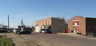
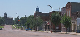
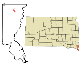
Burke is a city in and county seat of Gregory County, South Dakota, United States. The population was 575 at the 2020 census.

<span class="mw-page-title-main">Freeman, South Dakota</span> City in South Dakota, United States

Freeman is a city in Hutchinson County, South Dakota, United States. The population was 1,329 at the 2020 census.

<span class="mw-page-title-main">Parkston, South Dakota</span> City in South Dakota, United States

Parkston is a city in Hutchinson County, South Dakota, United States. The population was 1,567 at the 2020 census.

<span class="mw-page-title-main">Kadoka, South Dakota</span> City in South Dakota, United States

Kadoka is a city in, and the county seat of, Jackson County, South Dakota, United States. The population was 543 at the 2020 census. The town occupies about 2.3 square miles.

<span class="mw-page-title-main">Lennox, South Dakota</span> City in South Dakota, United States

Lennox is a city in Lincoln County, South Dakota, United States, located 20 miles (32 km) southwest of Sioux Falls. The population was 2,423 at the 2020 census.

<span class="mw-page-title-main">Tea, South Dakota</span> City in South Dakota, United States

Tea is a city in Lincoln County, South Dakota, United States and is a suburb of Sioux Falls. The population was 5,598 at the 2020 census.

<span class="mw-page-title-main">Britton, South Dakota</span> City in South Dakota, United States

Britton is a city in and the county seat of Marshall County, South Dakota, United States. The population was 1,215 at the 2020 census.

<span class="mw-page-title-main">Leola, South Dakota</span> City in South Dakota, United States

Leola is a small city in, and the county seat of, McPherson County, South Dakota, United States. It was founded on May 1, 1884, and named for Leola Haynes, daughter of one of the town's founders. The population was 434 as of the 2020 census.

<span class="mw-page-title-main">Baltic, South Dakota</span> City in South Dakota, United States

Baltic is a city on the Big Sioux River in northern Minnehaha County, South Dakota, United States. The population was 1,246 at the 2020 census.

<span class="mw-page-title-main">Crooks, South Dakota</span> City in South Dakota, United States

Crooks is a city in Minnehaha County, South Dakota, United States and is a suburb of Sioux Falls. The population was 1,362 at the 2020 census. Crooks was named New Hope until 1904. The town's present name honors W. A. Crooks, a local politician.

<span class="mw-page-title-main">Garretson, South Dakota</span> City in South Dakota, United States

Garretson is a city in Minnehaha County, South Dakota, United States. The city had a population of 1,228 at the 2020 census.

<span class="mw-page-title-main">Mission, South Dakota</span> City in South Dakota, United States

Mission is a city on the Rosebud Indian Reservation in northern Todd County, South Dakota, United States. The population was 1,156 at the 2020 census.

<span class="mw-page-title-main">Parker, South Dakota</span> City in South Dakota, U.S.

Parker is a city in Turner County, South Dakota, United States. The population was 1,194 at the 2020 census. It is the county seat of Turner County. Parker is bordered on its eastern side by South Dakota State Highway 19. Its northern side is bordered by South Dakota State Highway 44. Parker is located approximately 8 miles (13 km) northwest of Chancellor, 42 miles (68 km) east of Parkston and 41 miles (66 km) south of Madison.

<span class="mw-page-title-main">Alcester, South Dakota</span> City in South Dakota, United States

Alcester is a city in northern Union County, South Dakota, United States. It is part of the Sioux City, IA–NE–SD Metropolitan Statistical Area. The population was 820 at the 2020 census.

<span class="mw-page-title-main">Elk Point, South Dakota</span> City in South Dakota, United States

Elk Point is a city in and county seat of Union County, South Dakota, United States. The population was 2,149 as of the 2020 census.

<span class="mw-page-title-main">Eagle Butte, South Dakota</span> City in South Dakota, United States

Eagle Butte is a city in Dewey and Ziebach counties in South Dakota, United States. The population was 1,258 at the 2020 census.

References

  1. "SD Towns" (PDF). South Dakota State Historical Society. Archived from the original (PDF) on February 10, 2010. Retrieved February 10, 2010.
  2. "ArcGIS REST Services Directory". United States Census Bureau. Retrieved October 15, 2022.
  3. 1 2 U.S. Geological Survey Geographic Names Information System: Avon, South Dakota
  4. 1 2 "Census Population API". United States Census Bureau. Retrieved October 15, 2022.
  5. "U.S. Census Bureau: Avon city, South Dakota". www.census.gov. United States Census Bureau. Retrieved June 27, 2022.
  6. Hellmann, Paul T. (May 13, 2013). Historical Gazetteer of the United States. Routledge. p. 983. ISBN   978-1135948597 . Retrieved November 30, 2013.
  7. Federal Writers' Project (1940). South Dakota place-names, v.1-3. University of South Dakota. p. 25.
  8. "US Gazetteer files 2010". United States Census Bureau. Archived from the original on January 25, 2012. Retrieved June 21, 2012.
  9. United States Census Bureau. "Census of Population and Housing" . Retrieved July 20, 2014.
  10. "U.S. Census website". United States Census Bureau . Retrieved June 21, 2012.
  11. "U.S. Census website". United States Census Bureau . Retrieved January 31, 2008.
  12. "Avon School District 4-1". Avon School District 4-1. Retrieved August 5, 2012.

Commons-logo.svg Media related to Avon, South Dakota at Wikimedia Commons