Clay County is a county in the U.S. state of South Dakota. As of the 2020 census, the population was 14,967. The county seat is Vermillion, which is also home to the University of South Dakota. The county is named for Henry Clay, American statesman, US Senator from Kentucky, and United States Secretary of State in the 19th century.

Yankton County is a county in the U.S. state of South Dakota. As of the 2020 census, the population was 23,310. Its county seat is Yankton. Yankton County comprises the Yankton, SD Micropolitan Statistical Area.

Fall River County is a county in the U.S. state of South Dakota. As of the 2020 census, the population was 6,973. Its county seat is Hot Springs. The county was founded in 1883. It is named for Fall River which runs through it.

Dewey County is a county in the U.S. state of South Dakota. As of the 2020 census, the population was 5,239. Its county seat is Timber Lake. The county was created in 1883 and organized in 1910. It was named for William P. Dewey, Territorial surveyor-general from 1873 to 1877.
Charles Mix County is a county in the U.S. state of South Dakota. As of the 2020 United States Census, the population was 9,373. Its county seat is Lake Andes. The county was created in 1862 and organized in 1879. It was named for Charles Eli Mix, an official of the Bureau of Indian Affairs influential in signing a peace treaty with the local Lakota Indian tribes. The easternmost approximately 60% of the county comprises the Yankton Indian Reservation.

Bon Homme County is a county in the U.S. state of South Dakota. As of the 2020 census, the population was 7,003. Its county seat is Tyndall.
Sheridan County is a county in the U.S. state of Nebraska. As of the 2020 United States Census, the population was 5,127. Its county seat is Rushville. The county was formed in 1885, and was named for General Philip H. Sheridan.
Knox County is a county in the U.S. state of Nebraska. As of the 2020 United States Census, the population was 8,391. Its county seat is Center. Knox County was named for Continental and U.S. Army Major General Henry Knox.

Keya Paha County is a county in the U.S. state of Nebraska. As of the 2020 United States Census, the population was 769. Its county seat is Springview.

Dixon County is a county in the U.S. state of Nebraska. As of the 2020 United States Census, the population was 5,606. Its county seat is Ponca. The county was created in 1856 and attached to Dakota County. It was organized in 1858.

Dakota County is a county in the U.S. state of Nebraska. As of the 2020 United States Census, the population was 21,582. Its county seat is Dakota City.

Cherry County is a county located in the U.S. state of Nebraska. As of the 2020 United States Census, the population was 5,455. Its county seat is Valentine. The county was named for Lt. Samuel A. Cherry, an Army officer who was stationed at Fort Niobrara and who had been killed in South Dakota in 1881. Cherry County is in the Nebraska Sandhills. It is the largest county in the state at nearly 6,000 square miles (16,000 km2), larger than the state of Connecticut.

Cedar County is a county in the U.S. state of Nebraska. As of the 2020 United States Census, the population was 8,380. The county seat is Hartington. The county was formed in 1857, and was named for the Cedar tree groves in the area.

Niobrara is a village in Knox County, Nebraska, United States. The population was 363 at the 2020 census.

The Niobrara River is a tributary of the Missouri River, approximately 568 miles (914 km) long, running through the U.S. states of Wyoming and Nebraska. The river drains one of the most arid sections of the Great Plains, and has a low flow for a river of its length. The Niobrara's watershed includes the northern tier of Nebraska Sandhills, a small south-central section of South Dakota, as well as a small area of eastern Wyoming.
Winfred is an unincorporated community and census-designated place (CDP) in Lake County, South Dakota, United States, approximately 12 miles (19 km) west of Madison. The population was 38 as of the 2020 census. Winfred has been assigned the ZIP code of 57076.

Lewis and Clark Lake is a 31,400 acre (130 km²) reservoir located on the border of the U.S. states of Nebraska and South Dakota on the Missouri River. The lake is approximately 25 miles (40 km) in length with over 90 miles (140 km) of shoreline and a maximum water depth of 45 feet (14 m). The lake is impounded by Gavins Point Dam and is managed by the U.S. Army Corps of Engineers, Omaha District.
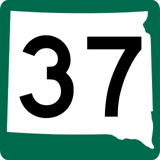
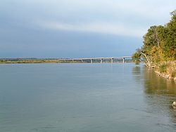
South Dakota Highway 37 is a state route that runs across eastern South Dakota. It begins at the Nebraska border northeast of Niobrara, Nebraska, as a continuation of Nebraska Highway 14. It runs to the North Dakota border north of Hecla, where it continues as North Dakota Highway 1. It is 242 miles (389 km) in length.
Bon Homme Colony is a census-designated place (CDP) in Bon Homme County, South Dakota, United States, comprising the Bon Homme Hutterite Colony. The population was 97 at the 2020 census. It was first listed as a CDP prior to the 2020 census.
Swift Bird is a census-designated place (CDP) on the Cheyenne River Indian Reservation in Dewey County, South Dakota, United States. It was first listed as a CDP prior to the 2020 census. The population of the CDP was 117 at the 2020 census.