The Nepali Congress is the oldest democratic socialist political party in Nepal and the largest party in the country. The party has 870,106 members as of the party's 14th general convention in December 2021 making them the largest party by membership in Nepal. Currently the party has started online membership since the emergence of youth leaders in vital post to bring youths into the party.

Biratnagar is a metropolitan city in Nepal, which serves as the capital of Koshi Province. With a Metropolitan Urban Agglomeration population of 244,750 as per the 2021 census, it is the largest city and fastest growing city in the province and also the headquarters of Morang district. As per the preliminary report of 2022 Nepal census, Biratnagar Metropolitan has an estimated city population of 244,750 excluding the suburban areas which are now very well connected to the old town. It is the administrative center of the Greater Birat Development Area which incorporates the cities of Biratnagar and its suburbs and towns of-Itahari-Gothgau-Biratchowk-Dharan primarily located on the Koshi Highway in Eastern Nepal, with an estimated total urban agglomerated population of 804,300 people in 159,332 households including the town of Ithari. Biratnagar is located 399 km (248 mi) east of the capital, Kathmandu, and 6 km (3.7 mi) north of the bordering town of Jogbani in the Indian state of Bihar. It is one of the major entry point in Nepal for Businessmen as well as Tourists who come to visit Nepal for various purposes.

Banepa is a municipality and historical town in a valley situated at about 1,500 m (4,900 ft) above sea level in central Nepal which is at about 25 kilometres (16 mi) east from Kathmandu. At the time of the 2011 Nepal census, it has a population of 67,690. The main attraction of Banepa is the temple of Chandeshwori, located approximately 1 km (0.62 mi) northeast of the town along the Rudramati River. The Dhaneshwor Temple is 1 KM south of the town. Banepa is also known for its eight different temples of Lord Ganesh, Narayanthan, Bhimshenthan and eight different ponds.

Kavrepalanchok District is one of the 77 districts of Nepal. The district, with Dhulikhel as its district headquarters, covers an area of 1,396 km2 (539 sq mi). It is a part of Bagmati Province and has a population of 364,039.

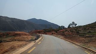
The Prithvi Highway is a 174-kilometre-long (108 mi) highway connecting Naubise of Tribhuvan Highway, 26 km from Kathmandu, the capital of Nepal, and Prithivi Chowk, Pokhara, a tourist city in the western part of Nepal.
Dhulikhel is a municipality in Kavrepalanchok District of Nepal. Two major highway B.P. Highway and Araniko Highway passes through Dhulikhel. Araniko Highway connects Kathmandu, Nepal's capital city with Tibet's border town of Kodari. Dhulikhel is located at the Eastern rim of Kathmandu Valley, south of the Himalayas at 1550m above sea level and is situated 30 km southeast of Kathmandu and 74 km southwest of Kodari. The Majority of people in Dhulikhel are Newars, and Brahmin, Chhettri, Tamang and Dalit are also living in outer area of the town. Drinking water in Dhulikhel is some of the best water in Nepal. It was made with the help of the German NGO German Technical Cooperation.

Dhulikhel Hospital, a Kathmandu University hospital, is an independent, not for profit, non-government hospital in Dhulikhel, Kavrepalanchok, Nepal.

Kamalamai is a municipality in Sindhuli District, in the Bagmati Province of central south Nepal. At the time of the 2011 Nepal census it had a population of 39,413 people in 9,304 households. The city is located in the Sindhuli Valley of central south Nepal. The historic symbol of the valley, Sindhuli Gadhi fort, is at the peak of a hill of the Mahabharata range. The city is in the plain valley made by the Kamla River. Kamalamai Municipality is the largest municipality of Nepal according to area.

Mahendra Highway, also called East-West Highway, runs across the Terai geographical region of Nepal, from Mechinagar in the east to Bhim Datta in the west, cutting across the entire width of the country. It is the longest highway in Nepal and was constructed in cooperation with various countries. The highway is named after King Mahendra Shah.
Kavre Nitya Chandeswori popularly known as "Kavre" is a village development committee in Kavrepalanchok District in the Bagmati Zone of central Nepal. Two of its V.D.C's are included in Dhulikhel Municipality in the year 2015 A.D. At the time of the 2011 Nepal census it had a population of 4,927 in 1,042 individual households.

Bardibas is a municipal area (municipality) and a town located in Mahottari District of Madhesh Province of Nepal. It is located at latitude: 26°54'6.84" to 27°08'46.90" and longitude: 85°47'42.67" to 85°56'42.97". The municipality is surrounded by Dhalkebar of Mithila municipality, Dhanusha District in the East and Ishworpur municipality of Sarlahi District in the West, Kamalamai municipality of Sindhuli District, Bagmati Province falls in the North and Bhangaha, Aurahi and Gaushala municipalities are located in the South.
Bhiman is a town in Kamalamai Municipality Ward no. 11 in Sindhuli District in the Janakpur Zone of south-eastern Nepal. At the time of the 1991 Nepal census it had a population of 7,609 people living in 1,389 individual households.
Garuda is a municipality in Rautahat District in the Narayani Zone of south-eastern Nepal. It is a newly created municipality by merging 7 former Village development committees namely Garuda Bairiya, Malahi, Basbiti Jingadiya, Gedahiguthi, Jayanagar, Mahamadpur and Pothiyahi.

Koshi Province is the autonomous easternmost province adopted on 20 September 2015 by Constitution of Nepal. The province is rich in natural resources, tourist attractions, recreational activities, and natural beauty. The province covers an area of 25,905 km2 (10,002 sq mi), about 17.5% of the country's total area. With the industrial city of Biratnagar as its capital, the province includes major eastern towns of Birtamod, Sundar Haraincha, Damak, Dharan, Itahari, Triyuga Municipality and Mechinagar, and the Mount Everest, Kangchenjunga and Ama Dablam. Koshi River, the largest river of the nation, forms the province's western boundary. Under the First-past-the-post voting system issued by the Constituency Delimitation Commission, Nepal, the province hosts 28 parliamentary seats and 56 provincial assembly seats.

Bagmati Province is one of the seven provinces of Nepal established by the constitution of Nepal. Bagmati is Nepal's second-most populous province and fifth largest province by area. It is bordered by Tibet Autonomous Region of China to the north, Gandaki Province to the west, Koshi Province to the east, Madhesh Province and the Indian state of Bihar to the south. With Hetauda as its provincial headquarters, the province is also the home to the country's capital Kathmandu, is mostly hilly and mountainous, and hosts mountain peaks including Gaurishankar, Langtang, Jugal, and Ganesh.

Nijgadh International Airport is a proposed hub-airport, located in Kolhabi, directly 68 km (42 mi) to the south of Kathmandu, near the town of Nijgadh in Madhesh Federal Province, Nepal. It is targeted to be completed by 2025 with an estimated investment of US$6.7 billion. If constructed, it would be the largest airport in South Asia and the fourth largest airport in the world in terms of land area. The airport is intended to relieve expected capacity restraints at Tribhuvan International Airport (TIA) in Kathmandu.

A municipality in Nepal is an administrative division in the Provinces of Nepal. The urban population of Nepal refers to the inhabitants residing in the designated municipal area. Population size has been taken as the principal criteria in the declaration of urban areas in Nepal since 1961. Municipalities can therefore also include rural areas. It functions as a sub-unit of a district. Nepal currently has 293 municipalities, which given the 2011 population estimate of 16,656,057.
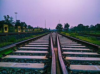
Department of Railways under Ministry of Physical Infrastructure and Transport is the authority to develop, maintain and plan railways in Nepal. It has its headquarter at Bishalnagar, Kathmandu. Currently it maintains three in-operation railway lines in the country: Raxaul–Sirsiya,Jainagar–Bhangaha and Bathnaha - Budhnagar. It is equivalent to Department of Road for road infrastructure. It has several lines been planned.

Kathmandu–Terai/Madhesh Expressway, also known as Fast Track, is an under construction road connecting Kathmandu and Nijgadh in southern Terai region of Nepal. The road is 70.977 kilometres (44.103 mi) long, of which, 48.037 kilometres (29.849 mi) is normal roads, 12.885 kilometres (8.006 mi) is bridges and 10.055 kilometres (6.248 mi) is tunnels. The expressway is being constructed by Nepal Army, originally scheduled to be completed by September 2021. The new set target date for completion is 2024. As of July 2021, 16.1% of the work has been completed.