
NatureScot is the operating name for the body formally called Scottish Natural Heritage. It is an executive non-departmental public body of the Scottish Government responsible for the country's natural heritage, especially its natural, genetic and scenic diversity. It advises the Scottish Government on nature conservation, and acts as a government agent in the delivery of conservation designations, i.e. national nature reserves, local nature reserves, national parks, Sites of Special Scientific Interest (SSSIs), Special Areas of Conservation, Special Protection Areas and the national scenic areas. It receives annual funding from the Government in the form of Grant in Aid to deliver Government priorities for the natural heritage.

The national nature reserves (NNRs) of Scotland are areas of land or water designated under the Wildlife and Countryside Act 1981 as containing habitats and species of national importance. National nature reserves can be owned by public, private, community or voluntary organisations but must be managed to conserve their important habitats and species, as well as providing opportunities for the public to enjoy and engage with nature. There are currently 43 NNRs in Scotland, which cover 154,250 hectares (1,542.5 km2), or less than 1.5% of the land area of Scotland. They range in size from Corrieshalloch Gorge at 7 ha to Mar Lodge Estate, which covers 29,324 ha.
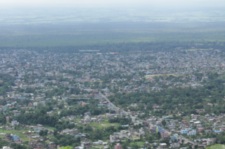
Dharan is a sub-metropolitan city in Sunsari District of Koshi Province, in eastern Nepal, which was established as a fourth municipality in the Kingdom in 1958. It is the third most populous city in eastern Nepal after Biratnagar and Itahari. The Nepali word "dharan" means a saw pit. The rainforest from which the tree trunks came is still just on the edge of the city. Much later the British Gurkha camp opened in October 1960. The use of the camp by British Gurkhas finished in the mid-1990s. Dharan has an estimated city population of 173,096 living in 34,834 households as per the 2021 Nepal census. It is one of the cities of the Greater Birat Development Area which incorporates the cities of Biratnagar-Itahari-Gothgau-Biratchowk-Dharan primarily located on the Koshi Highway in Eastern Nepal, with an estimated total urban agglomerated population of 804,300 people living in 159,332 households. It is the largest city in the province number one by Area. It covers 192.32 square kilometers while Biratnagar and Itahari is 2nd and 3rd biggest cities by Area
Dailekh District a part of Karnali Province, is one of the 77 districts of Nepal. The district, with Dailekh as its district headquarters, covers an area of 1,502 km2 (580 sq mi) and had a population of 225,201 in 2001 and 261,770 in 2011.

Khotang District is one of 14 districts of Koshi Province of eastern Nepal. The district, with Diktel as its district headquarters, covers an area of 1,591 km2 (614 sq mi) and has a population (2021) of 206,312. The district is bordered by Bhojpur District in the east, Udayapur District in the south, Okhaldhunga District in the west and Solukhumbu District in the North. In this district there are two municipalities and eight rural/urban municipalities.

Itahari is a sub-metropolitan city in the Sunsari District of Koshi Province in Nepal. Itahari city has grown as an important business hub of eastern Nepal. It is the second most populous city in eastern Nepal after Biratnagar. Situated 25 kilometres north of the provincial capital of Biratnagar, 16 kilometres south of Dharan and 92 kilometres west of Kakarbhitta, Itahari serves as a junction point of the east-west Mahendra Highway and the north–south Koshi Highway. Itahari has an estimated city population of 1,98,098 living in 40,207 households as per 2021 Nepal census. It is one of the fastest-growing cities in Eastern Nepal. It is one of the cities of the Greater Birat Development Area which incorporates the cities of Biratnagar-Itahari-Gothgau-Biratchowk-Dharan primarily located on the Koshi Highway in Eastern Nepal, with an estimated total urban agglomerated population of 804,300 people living in 159,332 households.

Amargadhi is a municipality and the district headquarter of Dadeldhura District in Sudurpashchim Province of western Nepal. It was named after Gorkha General Amar Singh Thapa, who fought in the Gurkha War between 1814 and 1816 At the time of the 2011 Nepal census it had a population of 21,245 people living in 4,778 individual households.

The Ministry of Road Transport and Highways (MoRTH) is a ministry of the Government of India, that is the apex body for formulation and administration of the rules, regulations and laws relating to road transport, transport research and in also to increase the mobility and efficiency of the road transport system in India. Through its officers of Central Engineering Services (Roads) cadre it is responsible for the development of National Highways of the country. Road transport is a critical infrastructure for economic development of the country. It influences the pace, structure and pattern of development. In India, roads are used to transport over 60 percent of the total goods and 85 percent of the passenger traffic. Hence, development of this sector is of paramount importance for India and accounts for a significant part in the budget.

National Highway 24 (NH 24) is a primary national highway in India, running in a north–south direction. This highway runs entirely in the state of Uttar Pradesh. This highway was created by renumbering former NH29 and NH97 as per new numbering system of national highways.

National Highway 22 is a National Highway in India. This highway runs from Sonbarsa in Bihar to Chandwa in Jharkhand. Sonbarsa is situated on India/ Nepal border.
National Highway 28 is a National Highway in India. This highway runs entirely in the state of Uttar Pradesh. It provides main connectivity form India to Nepal.

Koshi Province is the autonomous easternmost province adopted on 20 September 2015 by Constitution of Nepal. The province is rich in natural resources, tourist attractions, recreational activities, and natural beauty. The province covers an area of 25,905 km2 (10,002 sq mi), about 17.5% of the country's total area. With the industrial city of Biratnagar as its capital, the province includes major eastern towns of Birtamod, Sundar Haraincha, Damak, Dharan, Itahari, Triyuga Municipality and Mechinagar, and the Mount Everest, Kangchenjunga and Ama Dablam. Koshi River, the largest river of the nation, forms the province's western boundary. Under the First-past-the-post voting system issued by the Constituency Delimitation Commission, Nepal, the province hosts 28 parliamentary seats and 56 provincial assembly seats.

Bagmati Province is one of the seven provinces of Nepal established by the constitution of Nepal. Bagmati is Nepal's second-most populous province and fifth largest province by area. It is bordered by Tibet Autonomous Region of China to the north, Gandaki Province to the west, Koshi Province to the east, Madhesh Province and the Indian state of Bihar to the south. With Hetauda as its provincial headquarters, the province is also the home to the country's capital Kathmandu, is mostly hilly and mountainous, and hosts mountain peaks including Gaurishankar, Langtang, Jugal, and Ganesh.

NH06 or Tamor Corridor is a National Highway of Nepal that connects Terai in Sunsari District to Hills in Panchthar District in Koshi Province. It runs parallel of Tamur River via Sunsari District, Dhankuta District, Tehrathum District and Panchthar District. It starts from Tribeni (Chatara) of Barahakshetra Municipality in Sunsari and ends at Ambarpur of Hilihang Rural Municipality in Panchthar District. The total length of the road is 145 kilometres (90 mi).

NH04 or Birtamod-Bhadrapur road is a short National Highway of Nepal, located in Jhapa District of Koshi Province. The total length of the highway is just 12.53 kilometres (7.79 mi). The road is fully black topped four lane National Highway.

NH07 or Chatara–Nadaha–Kanchanrup Highway is a planned National Highway of Nepal which will be constructed between Koshi Province and Madhesh Province. The Highway section is in Sunsari District of Koshi Province and Saptari District of Madhesh Province. The road section starts from Jhanda Chowk of Chatara and passes through Nadaha chowk of Bharaul and Koshi Tappu Wildlife Reserve and finalize at Rupnagar of Kanchanrup municipality in Saptari district of Madhesh Province.
NH10 or Deurali-Mudhe-Bohoratar Highway is a National Highway of Nepal located in Koshi Province. The whole section of the highway is in Sankhuwasabha District. The total length of the highway is 92 kilometres (57 mi). The road section starts from Deurali and runs via Mudhe Sanishchare, Chainpur and finalizes merging with NH08 at Bohoratar.
NH11 or Phikkal-Chabbise road is a short National Highway of Nepal located in Koshi Province. The total length of the highway is just 19 kilometres (12 mi) and the whole section is located in Ilam District. It starts from Phikkal Bazar and runs via Chhiruwa, Mechi Bazar and finalizes at Chabbise which is an Indo-Nepal border located at the elevation of 1948 m. The road is connected with Indian State Highway SH12 (WB) at the other side of the border. NH11 is connected with NH02 at Phikkal Bazar.

