Baco, Oriental Mindoro

Last updated
Municipality of Baco
Baco Mahalta.jpg
Municipal Compound Gate
Flag of Baco, Oriental Mindoro.png
Ph seal oriental mindoro baco.png
Ph locator oriental mindoro baco.png
Map of Oriental Mindoro with Baco highlighted
OpenStreetMap
Baco, Oriental Mindoro
Philippines location map (square).svg
Red pog.svg
Municipality of Baco
Location within the Philippines
Coordinates: 13°21′30″N121°05′52″E / 13.358394°N 121.097664°E / 13.358394; 121.097664
Country Philippines
Region Mimaropa
Province Oriental Mindoro
District 1st district
Barangays 27 (see Barangays)
Government
[1]
  Type Sangguniang Bayan
   Mayor Allan A. Roldan
   Vice Mayor Reynaldo A. Marco
   Representative Arnan C. Panaligan
   Electorate 25,214 voters (2022)
Area
[2]
  Total216.23 km2 (83.49 sq mi)
Elevation
20 m (70 ft)
Highest elevation
480 m (1,570 ft)
Lowest elevation
0 m (0 ft)
Population
 (2020 census) [3]
  Total39,817
  Density180/km2 (480/sq mi)
   Households
9,182
Economy
   Income class 3rd municipal income class
   Poverty incidence
16.82
% (2018) [4]
   Revenue 169.6 million (2020)
   Assets 338.6 million (2020)
   Expenditure 163.8 million (2020)
   Liabilities 40.1 million (2020)
Service provider
  ElectricityOriental Mindoro Electric Cooperative (ORMECO)
Time zone UTC+8 (PST)
ZIP code
5201
PSGC
IDD : area code +63(0)43
Native languages Tagalog

Baco, officially the Municipality of Baco (Tagalog : Bayan ng Baco), is a 3rd class municipality in the province of Oriental Mindoro, Philippines. According to the 2020 census, it has a population of 39,817 people. [3]

Contents

History

The name “Baco” of the municipality rooted from two different Filipino words. The first is its origin from the word, “paco”, an edible fern reported to be abundant in the municipality. Its second origin, as told from folk stories by the elders, was from the word “baku-bako”, which means rough road. It used to describe the municipality for its road potholes due to frequent flooding calamities. Folk stories would claim that heavy rains would last in a span of three to four days.

Folktales

Baco is frequently affected by heavy rains and floods. There are several existing folktales to explain the frequent occurrence of floods in the municipality. One folktale consists of an old man who was denied of his request for water to drink. There was once a story of an area in Baco wherein an old thirsty man roamed looking for drinking water. He continually begged for water however no one came to his assistance to relieve him of his thirst. He was denied and instead chased him away. As he was about to leave, he cursed the locals saying, “You will be having water abundantly.” As time continued to pass, Baco has been a frequent catch basin of heavy rainfalls.

Another famous folktale of the municipality is about the early church of Baco and a priest who cursed the town. After the church was established, a Moro named Magyawi arrived. The convent was his residence and asked the priest to officiate masses only whenever he was around. Magyawi decided one day to go for hunting. As Magyawi enjoyed hunting for wild animals, his stay in the forest was extended. Due to this, the priest grew weary of waiting for Magyawi and decided on his own will to officiate the mass without him. On the arrival of Magyawi, he was furious with the violation of the priest. He then tied up the priest and placed him inside the crate. The missionary was confined without food. Unsatisfied with this punishment, Magyawi tied a big bell to the crate and threw it into the river. However, before being thrown into the river, the priest vowed and said, “This town will never prosper unless one natural born Bacoeño becomes a priest.”

First Capital of Oriental Mindoro

In a story told by anthropologist and missionary, Rev. Antoon Postma, the first parochial church in Oriental Mindoro was established in Baco in the year 1567. Due to this, it was declared the first official capital of Oriental Mindoro in 1575. Baco was considered the cabecera town. However, when Corregidor Joseph de Chavez became Governor of Oriental Mindoro in the year 1678, Calapan was declared the new capital of the province.

Spanish Colonization

As early as 1692, Baco had been the first to be under the Spanish mission, claiming it to be the oldest town in Mindoro. The Spanish regime began as Spanish friars settled along the shore of Tabon Tabon. Transferring to San Andres soon thereafter and were forced to relocate to Lumang Bayan due to the constant depredation of Muslim Pirates in the area. In Lumang Bayan, the first Gomahan Church was established. However, several years later in 1733, it was transferred to Calapan foreboding the first ecclesiastical jurisdiction over Mindoro.

Spanish Revolution

From years 1896 to 1900, the barrio captains of Baco were namely Juan Aceveda Sr., Pedro Quiambao, Quintin Villar, Gonzalo Aceveda, Bartolome Garcia and Cerbulo Leuterio. Honorary officials shifted from barrio captains to municipal presidents thereafter. The declared presidents of Baco were Benito R. Villar, Herminigildo Atienza, Jose Samaco, Jose Lopez, Juan Aceveda, Braulio Aceveda, Froilan Aceveda and Paterno Sanchez. During the Spanish revolution in the year 1898, the locals of Baco under the leadership of Captain Cervulo Leuterio joined the uprising. In the succeeding years 1899 to 1901, they subsequently joined the Americans.

Baco was under the jurisdiction of Calapan by the virtue of Act 1824 in the year 1902. Under the Act 3498, Baco regained its jurisdiction as a distinct municipality upon the representation of Mariano Leuterio, a legislative representative of Oriental Mindoro.

Foundation Day

The foundation day of Baco is being commemorated every 25th of January. Based on Executive Order No. 4 signed in Manila on January 25, 1921, by Francis Burton Harrison, Governor General of Philippine Islands, with the approval of the Chief Executive Bureau concurred by the Secretary of the Interior, Baco was recognized as a distinct municipality from Calapan. In addition to this is its accordance with article Six Chapter 64 of the Administrative Code of 1917 elaborated on the barrio of Baco and its separation from the Municipality of Calapan. It was organized as an independent district in Poblacion. The town proper was transferred to Alag in the year 1945. Later, it was transferred to San Andres. However, San Andres continued to be affected by soil erosion which forced people to relocate the town to the lot donated by Mr. Catalino Calderon. The town fiesta is being celebrated every 19th of March in honor of the municipal patron, Saint Joseph, Patron of the Worker.

Geography

Baco, Oriental Mindoro is a third-class municipality situated in the northern part of Oriental Mindoro approximately 120.93° East to 13.49° North and 121.19° West to 13.14° South. It is bounded by Subaan Bay in the North, Municipality of San Teodoro on the West, City of Calapan on the East, and Municipality of Santa Cruz, Occidental Mindoro on the South. The Municipality of Baco is a fifteen-minute drive away from the City of Calapan by land.

The municipality of Baco is composed of 27 barangays with a total land area of 31,126.023 hectares. The three largest barangays are San Ignacio, Lantuyang, and Bayanan which cover 22.75 percent, 22.40 percent, and 22.12 percent of the total land area, respectively. These barangays comprise most of the forestland area of the municipality. The smallest barangay with only 0.26 percent of the total land area of the municipality is Pulang Tubig.

Topography

Elevation

Majority of the barangays of the municipality are in lowland areas or below 500 meters above sea level (MASL) and cover 41.88 percent of the total land area (13,035.58 ha). The three largest barangays, which cover most of the forestland, have an elevation that ranges from 500-1,000 and greater than 1,000 meters above sea level. Moreover, Mount Halcon, which is found in Bayanan and Lantuyang, has the highest elevation in the entire province of Oriental Mindoro with an estimated height of 2,590 meters above sea level.

Slope

The slope of the municipality varies from 0 percent to 278 percent and there are six slope ranges identified in the Municipality of Baco. The zero to three percent slope category which is described as flat is found in lowlands, beach ridges, wetlands, broad and narrow alluvial plains, valleys and river terraces. Areas under this slope category have minimal land limitations wherein agricultural and other economic activities are done.

The slope category of three to eight percent, level to undulating areas, is found in residual terraces wherein fruit-bearing trees and terraced rice paddies are located. Slight land limitations such as soil erosion may be present in these areas.

There is a total area of 8,436.19 hectares under the zero to eight percent slope category in the municipality. These areas can be planted with a variety of lowland crops and are suitable for the development of commercial areas. For the slope category of eight to 18 percent, undulating to rolling slope areas is suitable for the cultivation of fruit-bearing trees and other perennial high value commercial crops. Baco has total land area of 1,899.21 hectares under this category. Limitations and constraints are present in these areas. Thus, utilizing these lands requires slight to moderate land development costs.

Meanwhile, 18 to 30 percent slope is categorized as rolling to moderately steep hills, and 30 to 50 percent, moderately to steeply mountainous, are found in the hilly and mountainous area of the municipality and have a combined land area of 10,444.32 hectares. Soil erosion is common in these areas.

More than 50 percent, very steeply mountainous, are in rugged terrain of hilly and mountainous region of the municipality and has a total land area of 10,346.31 hectares. Severe land limitations are present in this slope range. Barangay Pulantubig, San Andres, Pambisan, Putican Cabulo, Malapad, Tabon-Tabon, Catwiran I, Catwiran II, Poblacion, Alag, and Dulangan I have a slope range of zero to 18 percent. Barangay Tagumpay and Dulangan II have a slope range that varies from zero to 50 percent while barangay Water, Lumangbayan, Santa Cruz, Burbuli, Santa Rosa I, Santa Rosa II, Mangangan I, Mangangan II, Mayabig, Baras, Bangkatan, and San Ignacio have a slope range that varies from zero to 50 percent. Barangay Lantuyang and Bayanan have a slope range of 18 to 50 percent.

Overall, 20,790.63 hectares or more than half of the total land area of the municipality have a slope of 18 percent and above making the municipality more susceptible to soil erosion, rain-induced landslide, and excessive water run-off. Future plans of the municipality should consider the topographical characteristics in the selection of the locations of future investments. Most infrastructure investments in mountainous barangays are highly susceptible to landslide given its topographical location. Thus, this should be taken into consideration accompanied with the assessment of susceptible barangays to landslide.

Tourism

Mount Halcon, as one of the tourist sites in Baco, covers the largest area and pegged to be one of the “best hiking destination” in the country as stated in their promotional materials. All timberlands in the country are owned by the national government and so does Mt. Halcon. However, it does not offer any accommodation facilities at present (year 2018), however the hikers are accommodated in the evacuation center at Barangay Bayanan. In the area of barangay Lantuyang on the other hand, the climbers sometimes set up tents for days and nights prior to climbing up the mountain. Other houses in Lantuyang allow the hikers to stay with them when they are still waiting for the go-signal to climb. In exchange, some climbers have goods (i.e. school supplies, clothes, groceries) that they brought with them which they give to the host community. Bayanan and Lantuyang are the gateway barangays for the climbers of Mount Halcon.

Barangays

Climate

Climate data for Baco, Oriental Mindoro
MonthJanFebMarAprMayJunJulAugSepOctNovDecYear
Mean daily maximum °C (°F)28
(82)
29
(84)
30
(86)
31
(88)
31
(88)
30
(86)
29
(84)
29
(84)
29
(84)
29
(84)
29
(84)
28
(82)
29
(85)
Mean daily minimum °C (°F)22
(72)
22
(72)
22
(72)
23
(73)
25
(77)
25
(77)
25
(77)
25
(77)
25
(77)
24
(75)
23
(73)
22
(72)
24
(75)
Average precipitation mm (inches)48
(1.9)
32
(1.3)
41
(1.6)
54
(2.1)
257
(10.1)
410
(16.1)
466
(18.3)
422
(16.6)
429
(16.9)
300
(11.8)
137
(5.4)
92
(3.6)
2,688
(105.7)
Average rainy days10.88.09.811.723.127.529.228.728.725.518.212.8234
Source: Meteoblue [5]

Demographics

Population census of Baco
YearPop.±% p.a.
1939 5,111    
1948 5,751+1.32%
1960 10,213+4.90%
1970 13,687+2.97%
1975 15,738+2.84%
1980 18,607+3.40%
1990 23,800+2.49%
1995 25,915+1.61%
2000 30,167+3.31%
2007 34,127+1.72%
2010 35,060+0.99%
2015 37,215+1.14%
2020 39,817+1.34%
Source: Philippine Statistics Authority [6] [7] [8] [9]

Economy

Poverty Incidence of Baco

10
20
30
40
50
60
2006
57.20
2009
44.47
2012
22.76
2015
25.31
2018
16.82
2021
34.45

Source: Philippine Statistics Authority [10] [11] [12] [13] [14] [15] [16] [17]

Related Research Articles

<span class="mw-page-title-main">Oriental Mindoro</span> Province in Mimaropa, Philippines

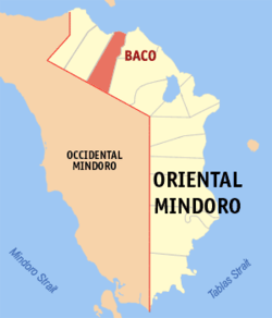
Oriental Mindoro, officially the Province of Oriental Mindoro, is a province in the Philippines located on the island of Mindoro under Mimaropa region in Luzon, about 140 kilometres (87 mi) southwest of Manila. The province is bordered by the Verde Island Passage and the rest of Batangas to the north, by Marinduque, Maestre de Campo Island, Tablas Strait and the rest of Romblon to the east, by Semirara and the rest of Caluya Islands, Antique to the south, and by Occidental Mindoro to the west. Calapan, the only city in the island, is the provincial capital and Mimaropa's regional center.

<span class="mw-page-title-main">Puerto Galera</span> Municipality in Oriental Mindoro, Philippines

Puerto Galera, officially the Municipality of Puerto Galera, is a 1st class municipality in the province of Oriental Mindoro, Philippines. According to the 2020 census, it has a population of 41,961 people.

<span class="mw-page-title-main">Mansalay</span> Municipality in Oriental Mindoro, Philippines

Mansalay, officially the Municipality of Mansalay, is a 2nd class municipality in the province of Oriental Mindoro, Philippines. According to the 2020 census, it has a population of 59,114 people.

<span class="mw-page-title-main">Pinamalayan</span> Municipality in Oriental Mindoro, Philippines

Pinamalayan, officially the Municipality of Pinamalayan, is a 1st class municipality in the province of Oriental Mindoro, Philippines. According to the 2020 census, it has a population of 90,383 people.

<span class="mw-page-title-main">Gloria, Oriental Mindoro</span> Municipality in Oriental Mindoro, Philippines

Gloria, officially the Municipality of Gloria, is a 3rd class municipality in the province of Oriental Mindoro, Philippines. According to the 2020 census, it has a population of 50,496 people.

<span class="mw-page-title-main">Lubang, Occidental Mindoro</span> Municipality in Occidental Mindoro, Philippines

Lubang, officially the Municipality of Lubang, is a 4th class municipality in the province of Occidental Mindoro, Philippines. According to the 2020 census, it has a population of 17,437 people.

<span class="mw-page-title-main">Magsaysay, Occidental Mindoro</span> Municipality in Occidental Mindoro, Philippines

Magsaysay, officially the Municipality of Magsaysay, is a 3rd class municipality in the province of Occidental Mindoro, Philippines. According to the 2020 census, it has a population of 39,767 people.

<span class="mw-page-title-main">Paluan</span> Municipality in Occidental Mindoro, Philippines

Paluan, officially the Municipality of Paluan, is a 3rd class municipality in the province of Occidental Mindoro, Philippines. According to the 2020 census, it has a population of 18,566 people.

<span class="mw-page-title-main">Sablayan</span> Municipality in Occidental Mindoro, Philippines

Sablayan, officially the Municipality of Sablayan, is a 1st class municipality in the province of Occidental Mindoro, Philippines. According to the 2020 census, it has a population of 92,598 people.

<span class="mw-page-title-main">Pola, Oriental Mindoro</span> Municipality in Oriental Mindoro, Philippines

Pola, officially the Municipality of Pola, is a 3rd class municipality in the province of Oriental Mindoro, Philippines. According to the 2020 census, it has a population of 35,455 people. It is 74 kilometres (46 mi) from Calapan.

<span class="mw-page-title-main">Quezon, Palawan</span> Municipality in Palawan, Philippines

Quezon, officially the Municipality of Quezon, is a 1st class municipality in the province of Palawan, Philippines. According to the 2020 census, it has a population of 65,283 people.

<span class="mw-page-title-main">Bansud</span> Municipality in Oriental Mindoro, Philippines

Bansud, officially the Municipality of Bansud, is a 2nd class municipality in the province of Oriental Mindoro, Philippines. According to the 2020 census, it has a population of 42,671 people.

<span class="mw-page-title-main">Bongabong</span> Municipality in Oriental Mindoro, Philippines

Bongabong, officially the Municipality of Bongabong, is a 1st class municipality in the province of Oriental Mindoro, Philippines. According to the 2020 census, it has a population of 76,973 people.

<span class="mw-page-title-main">Bulalacao</span> Municipality in Oriental Mindoro, Philippines

Bulalacao, officially the Municipality of Bulalacao, is a 3rd class municipality in the province of Oriental Mindoro, Philippines. According to the 2020 census, it has a population of 44,366 people.

<span class="mw-page-title-main">Calapan</span> Capital of Oriental Mindoro, Philippines

Calapan, officially the City of Calapan, is a 3rd class component city in the province of Oriental Mindoro, Philippines. According to the 2020 census, it has a population of 145,786 people. The city is the capital of the province of Oriental Mindoro.

<span class="mw-page-title-main">Naujan</span> Municipality in Oriental Mindoro, Philippines

Naujan, officially the Municipality of Naujan, is a 1st class municipality in the province of Oriental Mindoro, Philippines. Its population was 109,587 at the 2020 census.

<span class="mw-page-title-main">Roxas, Oriental Mindoro</span> Municipality in Oriental Mindoro, Philippines

Roxas, officially the Municipality of Roxas, is a 2nd class municipality in the province of Oriental Mindoro, Philippines. It has a population of 58,849 according to the 2020 census.

<span class="mw-page-title-main">San Teodoro, Oriental Mindoro</span> Municipality in Oriental Mindoro, Philippines

San Teodoro, officially the Municipality of San Teodoro, is a 4th class municipality in the province of Oriental Mindoro, Philippines. According to the 2020 census, it has a population of 19,121 people, making it the least populated municipality in the province.

<span class="mw-page-title-main">Socorro, Oriental Mindoro</span> Municipality in Oriental Mindoro, Philippines

Socorro, officially the Municipality of Socorro, is a 3rd class municipality in the province of Oriental Mindoro, Philippines. According to the 2020 census, it has a population of 41,585 people.

<span class="mw-page-title-main">Victoria, Oriental Mindoro</span> Municipality in Oriental Mindoro, Philippines

Victoria, officially the Municipality of Victoria, is a 2nd class municipality in the province of Oriental Mindoro, Philippines. According to the 2020 census, it has a population of 52,175 people.

References

  1. Municipality of Baco | (DILG)
  2. "2015 Census of Population, Report No. 3 – Population, Land Area, and Population Density" (PDF). Philippine Statistics Authority. Quezon City, Philippines. August 2016. ISSN   0117-1453. Archived (PDF) from the original on May 25, 2021. Retrieved July 16, 2021.
  3. 1 2 Census of Population (2020). "Mimaropa". Total Population by Province, City, Municipality and Barangay. Philippine Statistics Authority . Retrieved 8 July 2021.
  4. "PSA Releases the 2018 Municipal and City Level Poverty Estimates". Philippine Statistics Authority. 15 December 2021. Retrieved 22 January 2022.
  5. "Baco: Average Temperatures and Rainfall". Meteoblue. Retrieved 27 April 2020.
  6. Census of Population (2015). "Region IV-B (Mimaropa)". Total Population by Province, City, Municipality and Barangay. Philippine Statistics Authority . Retrieved 20 June 2016.
  7. Census of Population and Housing (2010). "Region IV-B (Mimaropa)" (PDF). Total Population by Province, City, Municipality and Barangay. National Statistics Office . Retrieved 29 June 2016.
  8. Censuses of Population (1903–2007). "Region IV-B (Mimaropa)". Table 1. Population Enumerated in Various Censuses by Province/Highly Urbanized City: 1903 to 2007. National Statistics Office.{{cite encyclopedia}}: CS1 maint: numeric names: authors list (link)
  9. "Province of Oriental Mindoro". Municipality Population Data. Local Water Utilities Administration Research Division. Retrieved 17 December 2016.
  10. "Poverty incidence (PI):". Philippine Statistics Authority. Retrieved December 28, 2020.
  11. "Estimation of Local Poverty in the Philippines" (PDF). Philippine Statistics Authority. 29 November 2005.
  12. "2003 City and Municipal Level Poverty Estimates" (PDF). Philippine Statistics Authority. 23 March 2009.
  13. "City and Municipal Level Poverty Estimates; 2006 and 2009" (PDF). Philippine Statistics Authority. 3 August 2012.
  14. "2012 Municipal and City Level Poverty Estimates" (PDF). Philippine Statistics Authority. 31 May 2016.
  15. "Municipal and City Level Small Area Poverty Estimates; 2009, 2012 and 2015". Philippine Statistics Authority. 10 July 2019.
  16. "PSA Releases the 2018 Municipal and City Level Poverty Estimates". Philippine Statistics Authority. 15 December 2021. Retrieved 22 January 2022.
  17. "PSA Releases the 2021 City and Municipal Level Poverty Estimates". Philippine Statistics Authority. 2 April 2024. Retrieved 28 April 2024.