Provinces of the Philippines | |
---|---|
Category | Province |
Location | Philippines |
Found in | Administrative and autonomous regions |
Number | 82 (as of 2022) |
Populations | 17,246–4,632,359 |
Areas | 219.01–17,030.75 km2 (84.56–6,575.61 sq mi) |
Government | |
Subdivisions |
Philippinesportal |
In the Philippines, provinces (Filipino : lalawigan or probinsiya) are one of its primary political and administrative divisions. There are 82 provinces at present, which are further subdivided into component cities and municipalities. The local government units in the National Capital Region, as well as independent cities, are independent of any provincial government. Each province is governed by an elected legislature called the Sangguniang Panlalawigan and an elected governor.
The provinces are grouped into seventeen regions based on geographical, cultural, and ethnological characteristics. Thirteen of these regions are numerically designated from north to south, while the National Capital Region, the Cordillera Administrative Region, the Southwestern Tagalog Region (Mimaropa), and the Bangsamoro Autonomous Region in Muslim Mindanao are only designated by acronyms.
Each province is a member of the League of Provinces of the Philippines, an organization that aims to address issues affecting provincial and metropolitan government administrations. [1]
A provincial government is autonomous of other provinces within the republic. Each province is governed by two main elected branches of the government: executive and legislative. Judicial affairs are separated from provincial governance and are administered by the Supreme Court of the Philippines. Each province has at least one branch of a Regional Trial Court.
The provincial governor is chief executive and head of each province. Elected to a term of three years and limited to three consecutive terms, he or she appoints the directors of each provincial department which include the office of administration, engineering office, information office, legal office, and treasury office.
The vice governor acts as the president for each Sangguniang Panlalawigan (SP; "Provincial Board"), the province's legislative body. Every SP is composed of regularly elected members from provincial districts, as well as ex officio members. The number of regularly elected SP members allotted to each province is determined by its income class. First- and second-class provinces are provided ten regular SP members; third- and fourth-class provinces have eight, while fifth- and sixth-class provinces have six. Exceptions are provinces with more than five congressional districts, such as Cavite with 16 regularly elected SP members, and Cebu, Negros Occidental and Pangasinan which have twelve each.
Every SP has designated seats for ex officio members, given to the respective local presidents of the Association of Barangay Captains (ABC), Philippine Councilors' League (PCL), and Sangguniang Kabataan (SK; "Youth Council").
The vice governor and regular members of an SP are elected by the voters within the province. Ex officio members are elected by members of their respective organizations.
National intrusion into the affairs of each provincial government is limited by the Philippine Constitution. The President of the Philippines however coordinates with provincial administrators through the Department of the Interior and Local Government. For purposes of national representation, each province is guaranteed its own congressional district. One congressional representative represents each district in the House of Representatives. Senatorial representation is elected at an at-large basis and not apportioned through territory-based districts.
Those classified as either "highly urbanized" or "independent component" cities are independent from the province, as provided for in Section 29 of the Local Government Code of 1991. [2] Although such a city is a self-governing second-level entity, in many cases it is often presented as part of the province in which it is geographically located, or in the case of Zamboanga City, the province it last formed part the congressional representation of.
Local government units classified as "component" cities and municipalities are under the jurisdiction of the provincial government. In order to make sure that all component city or municipal governments act within the scope of their prescribed powers and functions, the Local Government Code mandates the provincial governor to review executive orders issued by mayors, and the Sangguniang Panlalawigan to review legislation by the Sangguniang Panlungsod (City Council) or Sangguniang Bayan (Municipal Council), of all component cities and municipalities under the province's jurisdiction. [2]
The provincial government does not have direct relations with individual barangays. Supervision over a barangay government is the mandate of the mayor and the Sanggunian of the component city or municipality of which the barangay in question is a part. [2]
Provinces are classified according to average annual income based on the previous 4 calendar years. Effective July 29, 2008, the thresholds for the income classes for cities are: [3] [ needs update ]
Class | Average annual income |
---|---|
First | ₱450 million or more |
Second | ₱360 million or more but less than ₱450 million |
Third | ₱270 million or more but less than ₱360 million |
Fourth | ₱180 million or more but less than ₱270 million |
Fifth | ₱90 million or more but less than ₱180 million |
Sixth | below ₱90 million |
A province's income class determines the size of the membership of its Sangguniang Panlalawigan, and also how much it can spend on certain items, or procure through certain means. [2]
ISO [4] | Province | Capital | Population [5] | Area [6] | Density | Founded [upper-alpha 1] | Island group | Region | Total LGUs | |||
---|---|---|---|---|---|---|---|---|---|---|---|---|
PH-ABR | Abra | Bangued | 0.23% | 250,985 | 4,165.25 km2 (1,608.21 sq mi) | 60/km2 (156/sq mi) | 1846 | Luzon | CAR | 27 | — | 303 |
PH-AGN | Agusan del Norte [lower-roman 1] | Cabadbaran [lower-roman 2] [7] | 0.70% | 760,413 | 3,546.86 km2 (1,369.45 sq mi) | 214/km2 (555/sq mi) | 20 Sep 1907 | Mindanao | XIII | 10 | 2 | 253 |
PH-AGS | Agusan del Sur | Prosperidad | 0.68% | 739,367 | 9,989.52 km2 (3,856.98 sq mi) | 74/km2 (192/sq mi) | 1 Jan 1970 [8] | Mindanao | XIII | 13 | 1 | 314 |
PH-AKL | Aklan | Kalibo | 0.56% | 615,475 | 1,821.42 km2 (703.25 sq mi) | 338/km2 (875/sq mi) | 8 Nov 1956 [9] | Visayas | VI | 17 | — | 327 |
PH-ALB | Albay | Legazpi | 1.26% | 1,374,768 | 2,575.77 km2 (994.51 sq mi) | 534/km2 (1,382/sq mi) | 3 Apr 1574 [10] | Luzon | V | 15 | 3 | 720 |
PH-ANT | Antique | San Jose de Buenavista | 0.56% | 612,974 | 2,729.17 km2 (1,053.74 sq mi) | 225/km2 (582/sq mi) | 10 Mar 1917 | Visayas | VI | 18 | — | 590 |
PH-APA | Apayao | Kabugao [lower-roman 3] | 0.11% | 124,366 | 4,413.35 km2 (1,704.00 sq mi) | 28/km2 (73/sq mi) | 14 Feb 1995 | Luzon | CAR | 7 | — | 133 |
PH-AUR | Aurora | Baler | 0.22% | 235,750 | 3,147.32 km2 (1,215.19 sq mi) | 75/km2 (194/sq mi) | 13 Aug 1979 | Luzon | III | 8 | — | 151 |
PH-BAS | Basilan [lower-roman 4] | Lamitan [12] | 0.51% | 556,586 | 1,327.23 km2 (512.45 sq mi) [13] | 419/km2 (1,086/sq mi) | 27 Dec 1973 | Mindanao | BARMM [lower-roman 5] | 11 | 2 | 255 |
PH-BAN | Bataan | Balanga | 0.78% | 853,373 | 1,373.98 km2 (530.50 sq mi) | 622/km2 (1,610/sq mi) | 11 Jan 1754 | Luzon | III | 11 | 1 | 237 |
PH-BTN | Batanes | Basco | 0.02% | 18,831 | 219.01 km2 (84.56 sq mi) | 86/km2 (223/sq mi) | 26 Jun 1783 [14] | Luzon | II | 6 | — | 29 |
PH-BTG | Batangas | Batangas City | 2.67% | 2,908,494 | 3,119.72 km2 (1,204.53 sq mi) | 932/km2 (2,415/sq mi) | 8 Dec 1581 | Luzon | IV-A | 29 | 5 | 1,078 |
PH-BEN | Benguet [lower-roman 6] | La Trinidad | 0.76% | 827,041 | 2,826.59 km2 (1,091.35 sq mi) | 293/km2 (758/sq mi) | 16 Jun 1966 | Luzon | CAR | 13 | 1 | 269 |
PH-BIL | Biliran | Naval | 0.16% | 179,312 | 536.01 km2 (206.95 sq mi) | 335/km2 (866/sq mi) | 11 May 1992 | Visayas | VIII | 8 | — | 132 |
PH-BOH | Bohol | Tagbilaran | 1.28% | 1,394,329 | 4,820.95 km2 (1,861.38 sq mi) | 289/km2 (749/sq mi) | 22 Jul 1854 [15] | Visayas | VII | 47 | 1 | 1,109 |
PH-BUK | Bukidnon | Malaybalay | 1.41% | 1,541,308 | 10,498.59 km2 (4,053.53 sq mi) | 147/km2 (380/sq mi) | 10 Mar 1917 | Mindanao | X | 20 | 2 | 464 |
PH-BUL | Bulacan | Malolos | 3.40% | 3,708,890 | 2,796.10 km2 (1,079.58 sq mi) | 1,326/km2 (3,435/sq mi) | 15 Aug 1578 | Luzon | III | 21 | 3 | 569 |
PH-CAG | Cagayan | Tuguegarao | 1.16% | 1,268,603 | 9,295.75 km2 (3,589.11 sq mi) | 136/km2 (353/sq mi) | 29 Jun 1583 [16] | Luzon | II | 28 | 1 | 820 |
PH-CAN | Camarines Norte | Daet | 0.58% | 629,699 | 2,320.07 km2 (895.78 sq mi) | 271/km2 (703/sq mi) | 15 Apr 1920 [17] | Luzon | V | 12 | — | 282 |
PH-CAS | Camarines Sur [lower-roman 7] | Pili | 1.90% | 2,068,244 | 5,497.03 km2 (2,122.42 sq mi) | 376/km2 (974/sq mi) | 27 May 1579 [18] | Luzon | V | 35 | 2 | 1,063 |
PH-CAM | Camiguin | Mambajao | 0.09% | 92,808 | 237.95 km2 (91.87 sq mi) | 390/km2 (1,010/sq mi) | 18 Jun 1966 | Mindanao | X | 5 | — | 58 |
PH-CAP | Capiz | Roxas | 0.74% | 804,952 | 2,594.64 km2 (1,001.80 sq mi) | 310/km2 (804/sq mi) | 10 Mar 1917 | Visayas | VI | 16 | 1 | 473 |
PH-CAT | Catanduanes | Virac | 0.25% | 271,879 | 1,492.16 km2 (576.13 sq mi) | 182/km2 (472/sq mi) | 26 Sep 1945 | Luzon | V | 11 | — | 315 |
PH-CAV | Cavite | Imus [19] | 3.98% | 4,344,829 | 1,574.17 km2 (607.79 sq mi) | 2,760/km2 (7,149/sq mi) | 10 Mar 1614 [20] | Luzon | IV-A | 15 | 8 | 803 |
PH-CEB | Cebu [lower-roman 8] | Cebu City [21] | 4.72% | 5,151,274 | 5,342.00 km2 (2,062.56 sq mi) | 964/km2 (2,498/sq mi) | 27 Apr 1565 | Visayas | VII | 44 | 9 | 1,203 |
PH-NCO | Cotabato | Kidapawan | 1.17% | 1,275,185 | 9,008.90 km2 (3,478.36 sq mi) | 142/km2 (367/sq mi) | 1 Sep 1914 [22] | Mindanao | XII | 17 | 1 | 543 |
PH-COM | Davao de Oro | Nabunturan | 0.70% | 767,547 | 4,479.77 km2 (1,729.65 sq mi) | 171/km2 (444/sq mi) | 31 Jan 1998 | Mindanao | XI | 11 | — | 237 |
PH-DAV | Davao del Norte | Tagum | 1.03% | 1,125,057 | 3,426.97 km2 (1,323.16 sq mi) | 328/km2 (850/sq mi) | 8 May 1967 | Mindanao | XI | 8 | 3 | 223 |
PH-DAS | Davao del Sur [lower-roman 9] | Digos | 2.25% | 2,457,430 | 4,607.59 km2 (1,779.00 sq mi) | 533/km2 (1,381/sq mi) | 1 Sep 1914 | Mindanao | XI | 9 | 2 | 414 |
PH-DVO | Davao Occidental | Malita | 0.29% | 317,159 | 2,163.45 km2 (835.31 sq mi) | 147/km2 (380/sq mi) | 28 Oct 2013 | Mindanao | XI | 5 | — | 105 |
PH-DAO | Davao Oriental | Mati | 0.53% | 576,343 | 5,679.64 km2 (2,192.92 sq mi) | 101/km2 (263/sq mi) | 8 May 1967 | Mindanao | XI | 10 | 1 | 183 |
PH-DIN | Dinagat Islands | San Jose | 0.12% | 128,117 | 1,036.34 km2 (400.13 sq mi) | 124/km2 (320/sq mi) | 2 Dec 2006 | Mindanao | XIII | 7 | — | 100 |
PH-EAS | Eastern Samar | Borongan | 0.44% | 477,168 | 4,660.47 km2 (1,799.42 sq mi) | 102/km2 (265/sq mi) | 19 Jun 1965 | Visayas | VIII | 22 | 1 | 597 |
PH-GUI | Guimaras | Jordan | 0.17% | 187,842 | 604.57 km2 (233.43 sq mi) | 311/km2 (805/sq mi) | 22 May 1992 | Visayas | VI | 5 | — | 98 |
PH-IFU | Ifugao | Lagawe | 0.19% | 207,498 | 2,628.21 km2 (1,014.76 sq mi) | 79/km2 (204/sq mi) | 18 Jun 1966 | Luzon | CAR | 11 | — | 176 |
PH-ILN | Ilocos Norte | Laoag | 0.56% | 609,588 | 3,467.89 km2 (1,338.96 sq mi) | 176/km2 (455/sq mi) | 2 Feb 1818 | Luzon | I | 21 | 2 | 559 |
PH-ILS | Ilocos Sur | Vigan | 0.65% | 706,009 | 2,596.00 km2 (1,002.32 sq mi) | 272/km2 (704/sq mi) | 1572 | Luzon | I | 32 | 2 | 768 |
PH-ILI | Iloilo [lower-roman 10] | Iloilo City [21] | 2.30% | 2,509,525 | 5,079.17 km2 (1,961.08 sq mi) | 494/km2 (1,280/sq mi) | 1566 | Visayas | VI | 42 | 2 | 1,901 |
PH-ISA | Isabela [lower-roman 11] | Ilagan | 1.56% | 1,697,050 | 12,414.93 km2 (4,793.43 sq mi) | 137/km2 (354/sq mi) | 1 May 1856 | Luzon | II | 34 | 3 | 1,055 |
PH-KAL | Kalinga | Tabuk | 0.21% | 229,570 | 3,231.25 km2 (1,247.59 sq mi) | 71/km2 (184/sq mi) | 18 Jun 1966 | Luzon | CAR | 7 | 1 | 153 |
PH-LUN | La Union | San Fernando | 0.75% | 822,352 | 1,497.70 km2 (578.27 sq mi) | 549/km2 (1,422/sq mi) | 2 Mar 1850 | Luzon | I | 19 | 1 | 576 |
PH-LAG | Laguna | Santa Cruz | 3.10% | 3,382,193 | 1,917.85 km2 (740.49 sq mi) | 1,764/km2 (4,568/sq mi) | 28 Jul 1571 | Luzon | IV-A | 24 | 6 | 674 |
PH-LAN | Lanao del Norte [lower-roman 12] | Tubod | 1.00% | 1,086,017 | 4,159.94 km2 (1,606.16 sq mi) | 261/km2 (676/sq mi) | 4 Jul 1959 | Mindanao | X | 22 | 1 | 506 |
PH-LAS | Lanao del Sur | Marawi | 1.10% | 1,195,518 | 3,872.89 km2 (1,495.33 sq mi) [23] | 309/km2 (800/sq mi) | 1 Sep 1914 | Mindanao | BARMM | 39 | 1 | 1,159 |
PH-LEY | Leyte [lower-roman 13] | Tacloban [21] | 1.86% | 2,028,728 | 6,515.05 km2 (2,515.47 sq mi) | 311/km2 (806/sq mi) | 1735 | Visayas | VIII | 40 | 3 | 1,641 |
PH-MDN | Maguindanao del Norte [lower-roman 14] | Datu Odin Sinsuat | 0.85% | 926,037 | 4,752.47 km2 (1,834.94 sq mi) | 232/km2 (601/sq mi) | 17 Sep 2022 | Mindanao | BARMM | 12 | 1 | 189 |
PH-MDS | Maguindanao del Sur | Buluan | 0.68% | 741,221 | 4,973.48 km2 (1,920.27 sq mi) | 149/km2 (386/sq mi) | 22 Nov 1973 | Mindanao | BARMM | 24 | — | 167 |
PH-MAD | Marinduque | Boac | 0.22% | 239,207 | 952.58 km2 (367.79 sq mi) | 251/km2 (650/sq mi) | 21 Feb 1920 | Luzon | Mimaropa | 6 | — | 218 |
PH-MAS | Masbate | Masbate City | 0.83% | 908,920 | 4,151.78 km2 (1,603.01 sq mi) | 219/km2 (567/sq mi) | 18 Mar 1901 [24] | Luzon | V | 20 | 1 | 550 |
PH-MSC | Misamis Occidental | Oroquieta | 0.57% | 617,333 | 2,055.22 km2 (793.52 sq mi) | 300/km2 (778/sq mi) | 8 Nov 1929 | Mindanao | X | 14 | 3 | 490 |
PH-MSR | Misamis Oriental [lower-roman 15] | Cagayan de Oro [21] | 1.55% | 1,685,302 | 3,544.32 km2 (1,368.47 sq mi) | 475/km2 (1,232/sq mi) | 15 May 1901 | Mindanao | X | 23 | 3 | 504 |
PH-MOU | Mountain Province | Bontoc | 0.15% | 158,200 | 2,157.38 km2 (832.97 sq mi) | 73/km2 (190/sq mi) | 1846 | Luzon | CAR | 10 | — | 144 |
PH-NEC | Negros Occidental [lower-roman 16] | Bacolod [21] | 2.96% | 3,223,955 | 7,965.21 km2 (3,075.38 sq mi) | 405/km2 (1,048/sq mi) | 1 Jan 1890 [25] | Visayas | VI | 19 | 13 | 662 |
PH-NER | Negros Oriental | Dumaguete | 1.31% | 1,432,990 | 5,385.53 km2 (2,079.36 sq mi) | 266/km2 (689/sq mi) | 1 Jan 1890 [26] | Visayas | VII | 20 | 6 | 557 |
PH-NSA | Northern Samar | Catarman | 0.59% | 639,186 | 3,692.93 km2 (1,425.85 sq mi) | 173/km2 (448/sq mi) | 19 Jun 1965 | Visayas | VIII | 24 | — | 569 |
PH-NUE | Nueva Ecija | Palayan [lower-roman 17] | 2.12% | 2,310,134 | 5,751.33 km2 (2,220.60 sq mi) | 402/km2 (1,040/sq mi) | 25 Apr 1801 [27] | Luzon | III | 27 | 5 | 849 |
PH-NUV | Nueva Vizcaya | Bayombong | 0.46% | 497,432 | 3,975.67 km2 (1,535.01 sq mi) | 125/km2 (324/sq mi) | 24 May 1839 [28] | Luzon | II | 15 | — | 275 |
PH-MDC | Occidental Mindoro | Mamburao | 0.48% | 525,354 | 5,865.71 km2 (2,264.76 sq mi) | 90/km2 (232/sq mi) | 15 Nov 1950 [29] | Luzon | Mimaropa | 11 | — | 162 |
PH-MDR | Oriental Mindoro | Calapan | 0.83% | 908,339 | 4,238.38 km2 (1,636.45 sq mi) | 214/km2 (555/sq mi) | 1663 | Luzon | Mimaropa | 14 | 1 | 426 |
PH-PLW | Palawan [lower-roman 18] | Puerto Princesa [21] | 1.14% | 1,246,673 | 17,030.75 km2 (6,575.61 sq mi) | 73/km2 (190/sq mi) | 23 Jan 1902 | Luzon | Mimaropa | 23 | 1 | 433 |
PH-PAM | Pampanga [lower-roman 19] | San Fernando | 2.66% | 2,900,637 | 2,062.47 km2 (796.32 sq mi) | 1,406/km2 (3,643/sq mi) | 11 Dec 1571 | Luzon | III | 19 | 3 | 538 |
PH-PAN | Pangasinan [lower-roman 20] | Lingayen | 2.90% | 3,163,190 | 5,451.01 km2 (2,104.65 sq mi) | 580/km2 (1,503/sq mi) | 5 Apr 1580 [30] | Luzon | I | 44 | 4 | 1,364 |
PH-QUE | Quezon [lower-roman 21] | Lucena [21] | 2.04% | 2,229,383 | 9,069.60 km2 (3,501.79 sq mi) | 246/km2 (637/sq mi) | 1591 [31] | Luzon | IV-A | 39 | 2 | 1,242 |
PH-QUI | Quirino | Cabarroguis | 0.19% | 203,828 | 2,323.47 km2 (897.10 sq mi) | 88/km2 (227/sq mi) | 18 Jun 1966 | Luzon | II | 6 | — | 132 |
PH-RIZ | Rizal | Antipolo | 3.05% | 3,330,143 | 1,191.94 km2 (460.21 sq mi) | 2,794/km2 (7,236/sq mi) | 23 Feb 1853 | Luzon | IV-A | 13 | 1 | 189 |
PH-ROM | Romblon | Romblon | 0.28% | 308,985 | 1,533.45 km2 (592.07 sq mi) | 201/km2 (522/sq mi) | 16 Mar 1901 [32] | Luzon | Mimaropa | 17 | — | 219 |
PH-WSA | Samar | Catbalogan | 0.73% | 793,183 | 6,048.03 km2 (2,335.16 sq mi) | 131/km2 (340/sq mi) | 1768 | Visayas | VIII | 24 | 2 | 951 |
PH-SAR | Sarangani | Alabel | 0.51% | 558,946 | 3,601.25 km2 (1,390.45 sq mi) | 155/km2 (402/sq mi) | 16 Mar 1992 | Mindanao | XII | 7 | — | 141 |
PH-SIG | Siquijor | Siquijor | 0.09% | 103,395 | 337.49 km2 (130.31 sq mi) | 306/km2 (793/sq mi) | 17 Sep 1971 | Visayas | VII | 6 | — | 134 |
PH-SOR | Sorsogon | Sorsogon City | 0.76% | 828,655 | 2,119.01 km2 (818.15 sq mi) | 391/km2 (1,013/sq mi) | 17 Oct 1894 | Luzon | V | 14 | 1 | 541 |
PH-SCO | South Cotabato [lower-roman 22] | Koronadal | 1.53% | 1,672,791 | 4,428.81 km2 (1,709.97 sq mi) | 378/km2 (978/sq mi) | 18 Jun 1966 | Mindanao | XII | 10 | 2 | 225 |
PH-SLE | Southern Leyte | Maasin | 0.39% | 429,573 | 1,798.61 km2 (694.45 sq mi) | 239/km2 (619/sq mi) | 22 May 1959 | Visayas | VIII | 18 | 1 | 500 |
PH-SUK | Sultan Kudarat | Isulan | 0.78% | 854,052 | 5,298.34 km2 (2,045.70 sq mi) | 161/km2 (417/sq mi) | 22 Nov 1973 | Mindanao | XII | 11 | 1 | 249 |
PH-SLU | Sulu | Jolo | 0.92% | 1,000,108 | 1,600.40 km2 (617.92 sq mi) [33] | 625/km2 (1,619/sq mi) | 10 Mar 1917 | Mindanao | BARMM | 19 | — | 410 |
PH-SUN | Surigao del Norte | Surigao City | 0.49% | 534,636 | 1,972.93 km2 (761.75 sq mi) | 271/km2 (702/sq mi) | 15 May 1901 | Mindanao | XIII | 20 | 1 | 335 |
PH-SUR | Surigao del Sur | Tandag | 0.59% | 642,255 | 4,932.70 km2 (1,904.53 sq mi) | 130/km2 (337/sq mi) | 16 Jun 1960 | Mindanao | XIII | 17 | 2 | 309 |
PH-TAR | Tarlac | Tarlac City | 1.38% | 1,503,456 | 3,053.60 km2 (1,179.00 sq mi) | 492/km2 (1,275/sq mi) | 28 Mar 1873 [34] [35] | Luzon | III | 17 | 1 | 511 |
PH-TAW | Tawi-Tawi | Bongao [36] | 0.40% | 440,276 | 1,087.40 km2 (419.85 sq mi) [37] | 405/km2 (1,049/sq mi) | 11 Sep 1973 | Mindanao | BARMM | 11 | — | 203 |
PH-ZMB | Zambales [lower-roman 23] | Iba | 0.83% | 909,932 | 3,830.83 km2 (1,479.09 sq mi) | 238/km2 (615/sq mi) | 1578 | Luzon | III | 13 | 1 | 247 |
PH-ZAN | Zamboanga del Norte | Dipolog | 0.96% | 1,047,455 | 7,301.00 km2 (2,818.93 sq mi) | 143/km2 (372/sq mi) | 6 Jun 1952 | Mindanao | IX | 25 | 2 | 691 |
PH-ZAS | Zamboanga del Sur [lower-roman 24] | Pagadian | 1.86% | 2,027,902 | 5,914.16 km2 (2,283.47 sq mi) | 343/km2 (888/sq mi) | 1 Sep 1914 | Mindanao | IX | 26 | 2 | 779 |
PH-ZSI | Zamboanga Sibugay | Ipil | 0.61% | 669,840 | 3,607.75 km2 (1,392.96 sq mi) | 186/km2 (481/sq mi) | 22 Feb 2001 | Mindanao | IX | 16 | — | 389 |
PH-00 | Metro Manila | Manila † | 12.37% | 13,484,462 | 638.55 km2 (246.55 sq mi) | 21,117/km2 (54,694/sq mi) | — | Luzon | NCR [upper-alpha 2] | 1 | 16 | 1,706 |
| ||||||||||||
Table notes
|
This section provides insufficient context for those unfamiliar with the subject.(August 2013) |
When the United States acquired the Philippines from Spain in 1898, the islands were divided into four gobiernos (governments), which were further subdivided into provinces and districts. The American administration initially inherited the Spanish divisions and placed them under military government. As insurgencies were pacified, civil government was gradually organized.
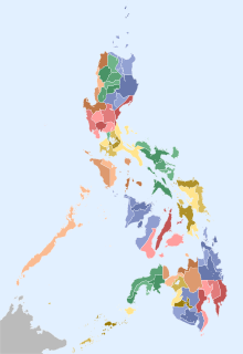
A city is one of the units of local government in the Philippines. All Philippine cities are chartered cities, whose existence as corporate and administrative entities is governed by their own specific municipal charters in addition to the Local Government Code of 1991, which specifies their administrative structure and powers. As of July 8, 2023, there are 149 cities.
Surigao del Norte, officially the Province of Surigao del Norte, is a province in the Philippines located in the Caraga region of Mindanao. The province was formerly under the jurisdiction of Region 10 until 1995. Its capital is Surigao City. The province comprises two major islands—Siargao and Bucas Grande—in the Philippine Sea, plus a small area at the northeastern tip of mainland Mindanao and other surrounding minor islands and islets. This mainland portion borders Agusan del Norte – between the Municipality of Alegria in Surigao del Norte and the Municipality of Kitcharao in Agusan del Norte; and the province of Surigao del Sur, to the south.
The House of Representatives of the Philippines is the lower house of Congress, the bicameral legislature of the Philippines, with the Senate of the Philippines as the upper house. The lower house is usually called Congress, although the term collectively refers to both houses.
Davao del Norte, officially the Province of Davao del Norte, is a province in the Philippines located in the Davao Region in Mindanao. Its capital and largest city is Tagum. The province also includes Samal Island to the south in Davao Gulf.
Davao de Oro, officially the Province of Davao de Oro, is a province in the Philippines located in the Davao Region in Mindanao. Its capital is Nabunturan. It used to be part of the province of Davao del Norte until it was made a separate province in 1998.
The Autonomous Region in Muslim Mindanao was an autonomous region of the Philippines, located in the Mindanao island group of the Philippines, that consisted of five predominantly Muslim provinces: Basilan, Lanao del Sur, Maguindanao, Sulu, and Tawi-Tawi. It was the only region that had its own government. The region's de facto seat of government was Cotabato City, although this self-governing city was outside its jurisdiction.
Dinagat Islands, officially the Province of Dinagat Islands, is an island province in the Caraga region of the Philippines, located on the south side of Leyte Gulf. The island of Leyte is to its west, across Surigao Strait, and mainland Mindanao is to its south. Its main island, Dinagat, is about 60 kilometres (37 mi) from north to south.
The legislative district of Agusan was the representation of the historical province of Agusan in the various national legislatures of the Philippines until 1969. Butuan also remained part of the province's representation even after becoming a chartered city in 1950.
The legislative district of Zamboanga was the representation of the historical province of Zamboanga in the various national legislatures of the Philippines until 1953. The undivided province's representation encompassed the present-day provinces of Basilan, Zamboanga del Norte, Zamboanga del Sur and Zamboanga Sibugay, and the highly urbanized city of Zamboanga.
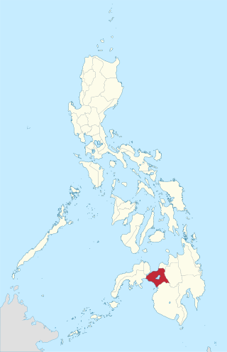
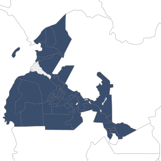
The legislative districts of Davao City are the representations of the highly urbanized city of Davao in the various national legislatures of the Philippines. The city is currently represented in the lower house of the Congress of the Philippines through its first, second, and third congressional districts.
The legislative districts of Davao del Norte are the representation of the province of Davao del Norte in the various national legislatures of the Philippines. The province is currently represented in the lower house of the Congress of the Philippines through its first and second congressional districts.
The legislative districts of Davao del Sur are the representations of the province of Davao del Sur in the various national legislatures of the Philippines. The province is currently represented in the lower house of the Congress of the Philippines through its lone congressional district.
The legislative district of Davao was the representation of the historical province of Davao in the various national legislatures of the Philippines until its dissolution in 1967.
The legislative district of Lanao was the representation of the historical province of Lanao in the various national legislatures of the Philippines until 1969. Marawi and Iligan also remained part of the province's representation even after becoming chartered cities in 1940 and 1950, respectively.
The legislative districts of Surigao del Norte are the representations of the province of Surigao del Norte in the various national legislatures of the Philippines. The province is currently represented in the lower house of the Congress of the Philippines through its first and second congressional districts. The 1st legislative district comprises nine municipalities on the islands of Siargao and Bucas Grande ; the 2nd legislative district comprises Surigao City and eleven other municipalities on the mainland of Mindanao.
The legislative districts of Surigao del Sur are the representations of the province of Surigao del Sur in the various national legislatures of the Philippines. The province is currently represented in the lower house of the Congress of the Philippines through its first and second congressional districts.
Lanao was a province of the Philippines from 1914 to 1959. Today, the province comprises Lanao del Norte and Lanao del Sur.
Davao's at-large congressional district may refer to several occasions when a provincewide at-large district was used for elections to the various Philippine national legislatures from the undivided province of Davao.
The Maguindanao division plebiscite was held in the province of Maguindanao, Philippines, on September 17, 2022, more than four months after the May 9 national and local elections, after having been postponed from its planned plebiscite in or before August 2021. As required by Republic Act No. 11550, it was conducted to seek the consent of the residents of Maguindanao on the proposal to divide the province into two separate provinces that will henceforth be named Maguindanao del Norte and Maguindanao del Sur.
{{cite journal}}
: Cite journal requires |journal=
(help){{cite web}}
: CS1 maint: multiple names: authors list (link){{cite journal}}
: Cite journal requires |journal=
(help)