Tinambac

Last updated
Tinambac
Municipality of Tinambac
San Pascual Baylon Parish Church.JPG
San Pascual Baylon Parish Church
Flag of Tinambac, Camarines Sur.png
Ph locator camarines sur tinambac.png
Map of Camarines Sur with Tinambac highlighted
OpenStreetMap
Tinambac
Philippines location map (square).svg
Red pog.svg
Tinambac
Location within the Philippines
Coordinates: 13°49′06″N123°19′28″E / 13.8183°N 123.3244°E / 13.8183; 123.3244
Country Philippines
Region Bicol Region
Province Camarines Sur
District 4th district
Founded 1888
Barangays 44 (see Barangays)
Government
[1]
  Type Sangguniang Bayan
   Mayor Ruel B. Tuy
   Vice Mayor Edward Albert P. Prades
   Representative Arnulf Bryan B. Fuentebella
   Municipal Council
Members
   Electorate 45,405 voters (2022)
Area
[2]
  Total351.62 km2 (135.76 sq mi)
Elevation
76 m (249 ft)
Highest elevation
1,972 m (6,470 ft)
Lowest elevation
0 m (0 ft)
Population
 (2020 census) [3]
  Total70,176
  Density200/km2 (520/sq mi)
   Households
15,167
Economy
   Income class 1st municipal income class
   Poverty incidence
36.77
% (2018) [4]
   Revenue 260.3 million (2020)
   Assets 387.9 million (2020)
   Expenditure 218.3 million (2020)
   Liabilities 96.61 million (2020)
Service provider
  ElectricityCamarines Sur 2 Electric Cooperative (CASURECO 2)
  WaterPartido Water Supply System
Time zone UTC+8 (PST)
ZIP code
4426
PSGC
IDD : area code +63(0)54
Native languages Central Bikol
Tagalog
Website www.tinambac.gov.ph

Tinambac, officially the Municipality of Tinambac (Central Bikol : Banwaan kan Tinambac; Tagalog : Bayan ng Tinambac), is a 1st class municipality in the province of Camarines Sur, Philippines. According to the 2020 census, it has a population of 70,176 people. [3]

Contents

History

The town of Tinambac was considered to be a trading center of villages surrounding the eastern side of Mt. Isarog. It was in this place where tobacco, then a prohibited product, was exchanged by the townspeople of Tinambac.

Its establishment as a separate municipality occurred during the latter part of the 18th century and this was known as the mission post of Himoragat. In 1829 when the Spanish administration divided the province of Camarines Sur into four districts, Tinambac fall under the District of Isarog.

A church was built atop a hill which still stands at present where the residents of this simple town give way to the celebration of its fiesta every 17th day of May. St. Pascual Baylon is the patron saint of this town.

Geography

Barangays

Tinambac is politically subdivided into 44 barangays. Each barangay consists of puroks and some have sitios.

  • Agay-Ayan
  • Antipolo
  • Bagacay
  • Banga
  • Bolaobalite
  • Bani
  • Bataan
  • Binalay (Poblacion)
  • Buenavista
  • Buyo
  • Cagliliog
  • Caloco
  • Camagong
  • Canayonan
  • Cawaynan
  • Daligan
  • Filarca (Poblacion)
  • La Purisima (Poblacion)
  • Lupi
  • Magsaysay (Camp 4)
  • Magtang
  • Mananao
  • La Medalla (Mile 9)
  • New Caaluan
  • Olag Grande
  • Olag Pequeño
  • Old Caaluan
  • Pag-Asa
  • Pantat
  • Sagrada (Camp 6)
  • Salvacion
  • San Antonio
  • San Isidro (Poblacion)
  • San Jose (Tiltilan)
  • San Pascual (Poblacion)
  • San Ramon (Camp 7)
  • San Roque
  • San Vicente
  • Santa Cruz (Poblacion)
  • Sogod
  • Tambang
  • Tierra Nevada
  • Union
  • Salvacion Poblacion

Climate

Climate data for Tinambac, Camarines Sur
MonthJanFebMarAprMayJunJulAugSepOctNovDecYear
Mean daily maximum °C (°F)31
(88)
30
(86)
33
(91)
35
(95)
36
(97)
36
(97)
35
(95)
34
(93)
35
(95)
33
(91)
32
(90)
31
(88)
33
(92)
Mean daily minimum °C (°F)27
(81)
27
(81)
28
(82)
30
(86)
31
(88)
31
(88)
30
(86)
30
(86)
30
(86)
29
(84)
28
(82)
28
(82)
29
(84)
Average precipitation mm (inches)62.63
(2.47)
114.71
(4.52)
41.44
(1.63)
56.32
(2.22)
105.22
(4.14)
175.86
(6.92)
192.89
(7.59)
110.61
(4.35)
130.78
(5.15)
546.13
(21.50)
232.90
(9.17)
462
(18.2)
2,231.49
(87.86)
Average rainy days212514172329312327292931299
Source: World Weather Online [5]

Demographics

Population census of Tinambac
YearPop.±% p.a.
1903 4,880    
1918 5,507+0.81%
1939 10,921+3.31%
1948 14,103+2.88%
1960 28,897+6.16%
1970 36,357+2.32%
1975 34,415−1.09%
1980 39,621+2.86%
1990 46,570+1.63%
1995 49,185+1.03%
2000 55,608+2.67%
2007 59,125+0.85%
2010 62,435+2.00%
2015 67,572+1.52%
2020 70,176+0.75%
Source: Philippine Statistics Authority [6] [7] [8] [9]

In the 2020 census, the population of Tinambac was 70,176 people, [3] with a density of 200 inhabitants per square kilometre or 520 inhabitants per square mile.

Bikol is the predominant language.

Economy

Poverty Incidence of Tinambac

10
20
30
40
50
60
2006
51.30
2009
53.20
2012
47.40
2015
51.36
2018
36.77
2021
47.71

Source: Philippine Statistics Authority [10] [11] [12] [13] [14] [15] [16] [17]

Total agricultural area is estimated to be 17,230 hectares (42,600 acres), 96% of which are planted with coconut. Only around 4% are devoted to rice, corn, banana and root crops. Fishponds cover around 464 hectares (1,150 acres) or 1.8% of the total agricultural area.

Infrastructure

Communication facilities
Health services

Related Research Articles

<span class="mw-page-title-main">Baao</span> Municipality in Camarines Sur, Philippines

Baao, officially the Municipality of Baao is 1st class municipality in the province of Camarines Sur, Philippines. According to the 2020 census, it has a population of 61,493 people.

<span class="mw-page-title-main">Bato, Camarines Sur</span> Municipality in Camarines Sur, Philippines

Bato, officially the Municipality of Bato, is a 3rd class municipality in the province of Camarines Sur, Philippines. According to the 2020 census, it has a population of 52,155 people.

<span class="mw-page-title-main">Bula, Camarines Sur</span> Municipality in Camarines Sur, Philippines

Bula, officially the Municipality of Bula, is a 1st class municipality in the province of Camarines Sur, Philippines. According to the 2020 census, it had a population of 73,143 people.

<span class="mw-page-title-main">Calabanga</span> Municipality in Camarines Sur, Philippines

Calabanga, officially the Municipality of Calabanga, is a 1st class municipality in the province of Camarines Sur, Philippines. According to the 2020 census, it has a population of 88,906 people.

<span class="mw-page-title-main">Del Gallego</span> Municipality in Camarines Sur, Philippines

Del Gallego, officially the Municipality of Del Gallego, is a 4th class municipality in the province of Camarines Sur, Philippines. According to the 2020 census, it has a population of 26,403 people.

<span class="mw-page-title-main">Garchitorena</span> Municipality in Camarines Sur, Philippines

Garchitorena, officially the Municipality of Garchitorena, is a 4th class municipality in the province of Camarines Sur, Philippines. According to the 2020 census, it has a population of 29,436 people.

<span class="mw-page-title-main">Goa, Camarines Sur</span> Municipality in Camarines Sur, Philippines

Goa, officially the Municipality of Goa, is a 1st class municipality in the province of Camarines Sur, Philippines. According to the 2020 census, it has a population of 71,368 people.

<span class="mw-page-title-main">Lagonoy</span> Municipality in Camarines Sur, Philippines

Lagonoy, officially the Municipality of Lagonoy, is a 2nd class municipality in the province of Camarines Sur, Philippines. According to the 2020 census, it has a population of 56,714 people.

<span class="mw-page-title-main">Lupi, Camarines Sur</span> Municipality in Camarines Sur, Philippines

Lupi, officially the Municipality of Lupi, is a 3rd class municipality in the province of Camarines Sur, Philippines. According to the 2020 census, it has a population of 33,897 people.

<span class="mw-page-title-main">Magarao</span> Municipality in Camarines Sur, Philippines

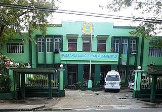
Magarao, officially the Municipality of Magarao, is a 3rd class municipality in the province of Camarines Sur, Philippines. According to the 2020 census, it has a population of 26,742 people.

<span class="mw-page-title-main">Milaor</span> Municipality in Camarines Sur, Philippines

Milaor, officially the Municipality of Milaor, is a 3rd class municipality in the province of Camarines Sur, Philippines. According to the 2020 census, it has a population of 33,963 people.

<span class="mw-page-title-main">Minalabac</span> Municipality in Camarines Sur, Philippines

Minalabac, officially the Municipality of Minalabac, is a 2nd class municipality in the province of Camarines Sur, Philippines. According to the 2020 census, it has a population of 53,981 people.

<span class="mw-page-title-main">Ocampo, Camarines Sur</span> Municipality in Camarines Sur, Philippines

Ocampo, officially the Municipality of Ocampo, is a 1st class municipality in the province of Camarines Sur, Philippines. According to the 2020 census, it has a population of 51,073 people.

<span class="mw-page-title-main">Pamplona, Camarines Sur</span> Municipality in Camarines Sur, Philippines

Pamplona, officially the Municipality of Pamplona, is a 3rd class municipality in the province of Camarines Sur, Philippines. According to the 2020 census, it has a population of 39,333 people.

<span class="mw-page-title-main">Pili, Camarines Sur</span> Capital of Camarines Sur, Philippines

Pili, officially the Municipality of Pili is a 1st class municipality and capital of the province of Camarines Sur, Philippines. According to the 2020 census, it has a population of 99,196 people.

<span class="mw-page-title-main">Presentacion</span> Municipality in Camarines Sur, Philippines

Presentacion, officially the Municipality of Presentacion, is a 4th class municipality in the province of Camarines Sur, Philippines. According to the 2020 census, it has a population of 22,591 people.

<span class="mw-page-title-main">Ragay</span> Municipality in Camarines Sur, Philippines

Ragay, officially the Municipality of Ragay, is a 1st class municipality in the province of Camarines Sur, Philippines. According to the 2020 census, it has a population of 59,770 people.

<span class="mw-page-title-main">Sagñay</span> Municipality in Camarines Sur, Philippines

Sagñay,, officially the Municipality of Sagñay, is a 4th class municipality in the province of Camarines Sur in the Philippines. It has an land area of 154.76 sq kilometers. According to the 2020 census, it has a population of 36,841 people. Based of this information, there is a population density of 238 people per sq kilometer.

<span class="mw-page-title-main">Siruma</span> Municipality in Camarines Sur, Philippines

Siruma, officially the Municipality of Siruma, is a 4th class municipality in the province of Camarines Sur, Philippines. According to the 2020 census, it has a population of 19,419 people.

<span class="mw-page-title-main">Tigaon, Camarines Sur</span> Municipality in Camarines Sur, Philippines

Tigaon, officially the Municipality of Tigaon, is a 2nd class municipality in the province of Camarines Sur, Philippines. According to the 2020 census, it has a population of 60,524 people.

References

  1. Municipality of Tinambac | (DILG)
  2. "2015 Census of Population, Report No. 3 – Population, Land Area, and Population Density" (PDF). Philippine Statistics Authority. Quezon City, Philippines. August 2016. ISSN   0117-1453. Archived (PDF) from the original on May 25, 2021. Retrieved July 16, 2021.
  3. 1 2 3 Census of Population (2020). "Region V (Bicol Region)". Total Population by Province, City, Municipality and Barangay. Philippine Statistics Authority . Retrieved 8 July 2021.
  4. "PSA Releases the 2018 Municipal and City Level Poverty Estimates". Philippine Statistics Authority. 15 December 2021. Retrieved 22 January 2022.
  5. "Tinambac, Camarines Sur: Average Temperatures and Rainfall". World Weather Online. Retrieved 29 October 2017.
  6. Census of Population (2015). "Region V (Bicol Region)". Total Population by Province, City, Municipality and Barangay. Philippine Statistics Authority . Retrieved 20 June 2016.
  7. Census of Population and Housing (2010). "Region V (Bicol Region)" (PDF). Total Population by Province, City, Municipality and Barangay. National Statistics Office . Retrieved 29 June 2016.
  8. Censuses of Population (1903–2007). "Region V (Bicol Region)". Table 1. Population Enumerated in Various Censuses by Province/Highly Urbanized City: 1903 to 2007. National Statistics Office.{{cite encyclopedia}}: CS1 maint: numeric names: authors list (link)
  9. "Province of Camarines Sur". Municipality Population Data. Local Water Utilities Administration Research Division. Retrieved 17 December 2016.
  10. "Poverty incidence (PI):". Philippine Statistics Authority. Retrieved December 28, 2020.
  11. "Estimation of Local Poverty in the Philippines" (PDF). Philippine Statistics Authority. 29 November 2005.
  12. "2003 City and Municipal Level Poverty Estimates" (PDF). Philippine Statistics Authority. 23 March 2009.
  13. "City and Municipal Level Poverty Estimates; 2006 and 2009" (PDF). Philippine Statistics Authority. 3 August 2012.
  14. "2012 Municipal and City Level Poverty Estimates" (PDF). Philippine Statistics Authority. 31 May 2016.
  15. "Municipal and City Level Small Area Poverty Estimates; 2009, 2012 and 2015". Philippine Statistics Authority. 10 July 2019.
  16. "PSA Releases the 2018 Municipal and City Level Poverty Estimates". Philippine Statistics Authority. 15 December 2021. Retrieved 22 January 2022.
  17. "PSA Releases the 2021 City and Municipal Level Poverty Estimates". Philippine Statistics Authority. 2 April 2024. Retrieved 28 April 2024.