Minalabac

Last updated
Minalabac
Municipality of Minalabac
Bagolatao, Minalabac, Camarines Sur.JPG
White pebble beach in Bagolatao
Flag of Minalabac, Camarines Sur.png
Minalabac Camarines Sur.png
Ph locator camarines sur minalabac.png
Map of Camarines Sur with Minalabac highlighted
OpenStreetMap
Minalabac
Philippines location map (square).svg
Red pog.svg
Minalabac
Location within the Philippines
Coordinates: 13°34′12″N123°11′04″E / 13.57°N 123.1844°E / 13.57; 123.1844
Country Philippines
Region Bicol Region
Province Camarines Sur
District 2nd district
Barangays 25 (see Barangays)
Government
[1]
  Type Sangguniang Bayan
   Mayor Christopher R. Lizardo
   Vice Mayor Noe G. Lavandero
   Representative Luis Raymund F. Villafuerte Jr.
   Municipal Council
Members
   Electorate 32,734 voters (2022)
Area
[2]
  Total126.10 km2 (48.69 sq mi)
Elevation
7.0 m (23.0 ft)
Highest elevation
518 m (1,699 ft)
Lowest elevation
−3 m (−10 ft)
Population
 (2020 census) [3]
  Total53,981
  Density430/km2 (1,100/sq mi)
   Households
11,622
Economy
   Income class 2nd municipal income class
   Poverty incidence
32.21
% (2018) [4]
   Revenue 166.4 million (2020)
   Assets 705.6 million (2020)
   Expenditure 92.15 million (2020)
   Liabilities 71.96 million (2020)
Service provider
  ElectricityCamarines Sur 2 Electric Cooperative (CASURECO 2)
Time zone UTC+8 (PST)
ZIP code
4414
PSGC
IDD : area code +63(0)54
Native languages Central Bikol
Tagalog

Minalabac, officially the Municipality of Minalabac (Central Bikol : Banwaan kan Minalabac, Tagalog : Bayan ng Minalabac), is a 2nd class municipality in the province of Camarines Sur, Philippines. According to the 2020 census, it has a population of 53,981 people. [3]

Contents

Geography

Barangays

Minalabac is politically subdivided into 25 barangays. Each barangay consists of puroks and some have sitios.

  • Antipolo
  • Bagolatao
  • Bagongbong
  • Baliuag Nuevo
  • Baliuag Viejo
  • Catanusan
  • Del Carmen-Del Rosario (Poblacion)
  • Del Socorro
  • Hamoraon
  • Hobo
  • Irayang Solong
  • Magadap
  • Malitbog
  • Manapao
  • Mataoroc
  • Sagrada (Sagrada Familia)
  • Salingogon
  • San Antonio
  • San Felipe-Santiago (Poblacion)
  • San Francisco (Poblacion)
  • San Jose
  • San Juan-San Lorenzo (Poblacion)
  • Taban
  • Tariric
  • Timbang

Climate

Climate data for Minalabac, Camarines Sur
MonthJanFebMarAprMayJunJulAugSepOctNovDecYear
Average high °C (°F)33
(91)
32
(90)
35
(95)
37
(99)
38
(100)
36
(97)
35
(95)
33
(91)
35
(95)
34
(93)
33
(91)
32
(90)
34
(94)
Average low °C (°F)27
(81)
27
(81)
29
(84)
31
(88)
32
(90)
32
(90)
31
(88)
29
(84)
30
(86)
29
(84)
28
(82)
28
(82)
29
(85)
Average precipitation mm (inches)36.66
(1.44)
58.6
(2.31)
37.91
(1.49)
76.31
(3.00)
98.34
(3.87)
151.99
(5.98)
288.39
(11.35)
291.41
(11.47)
186.77
(7.35)
363.21
(14.30)
97.5
(3.84)
292.1
(11.50)
1,979.19
(77.9)
Average rainy days182316172528312627292429293
Source: World Weather Online [5]

Demographics

Population census of Minalabac
YearPop.±% p.a.
1903 3,993    
1918 4,094+0.17%
1939 9,620+4.15%
1948 11,984+2.47%
1960 19,654+4.21%
1970 23,373+1.75%
1975 27,089+3.00%
1980 30,336+2.29%
YearPop.±% p.a.
1990 35,922+1.70%
1995 37,574+0.85%
2000 41,734+2.28%
2007 43,957+0.72%
2010 48,162+3.38%
2015 52,390+1.62%
2020 53,981+0.59%
Source: Philippine Statistics Authority [6] [7] [8] [9]

In the 2020 census, the population of Minalabac was 53,981 people, [3] with a density of 430 inhabitants per square kilometre or 1,100 inhabitants per square mile.

Economy

Minalabac is classified as a 2nd class municipality. Minalabac has the same economy as Libmanan, Cabusao, San Fernando, Milaor, Ocampo, Nabua, and Calabanga because of fishing in coastal barangays near Ragay Gulf particularly Salingogon, and Bagolatao. Minalabac has several beach resorts that also boosts the economy of the town. Majority of the land is devoted to rice, vegetables and other root crops.

Transportation

Buses are used for transportation from Naga City to Minalabac, and from Bicol Central Station in Triangulo to the market of Minalabac. It is also accessible by Naga Airport in San Jose, Pili, Camarines Sur just by taking a 45 minute flight from Manila to Naga Airport and then take a jeepney going to the Minalabac public market.

Infrastructures

The town has a couple of provincial roads. The main road in the town is the Milaor-Minalabac-Pili road and the other roads either goes to the Poblacion, other barangays, to Rinconada district, or even Albay.

Tourism

Two main summer beach destinations include the pebble beach in Bagolatao and sand beach in Hamoraon. The growing number of resorts offers amenities such as cottages, videoke, rest house, etc.[ citation needed ]

Government

Minalabac Municipal Hall MinalabacMunisipyo 005.jpg
Minalabac Municipal Hall

Elected officials

Members of the Minalabac Municipal Council
(2019-2022) [17]
PositionName of official
District Representative (2nd Legislative District, Camarines Sur)Rep. Luis Raymund F. Villafuerte Jr.
MayorChristopher R. Lizardo
Vice-MayorPedro M. Benamira
CouncilorsMiguel S. Bersabe
Renato A. Barcinas
Noe G. Lavandero
Louieley S. Barrameda
Alejo Francis R. Sayson
Pedro S. Balid
Alex L. Nacor
Arcel B. Bas

Related Research Articles

<span class="mw-page-title-main">Mercedes, Camarines Norte</span> Municipality in Camarines Norte, Philippines

Mercedes, officially the Municipality of Mercedes, is a 2nd class municipality in the province of Camarines Norte, Philippines. According to the 2020 census, it has a population of 55,334 people.

<span class="mw-page-title-main">Baao</span> Municipality in Camarines Sur, Philippines

Baao, officially the Municipality of Baao is 1st class municipality in the province of Camarines Sur, Philippines. According to the 2020 census, it has a population of 61,493 people.

<span class="mw-page-title-main">Bato, Camarines Sur</span> Municipality in Camarines Sur, Philippines

Bato, officially the Municipality of Bato, is a 3rd class municipality in the province of Camarines Sur, Philippines. According to the 2020 census, it has a population of 52,155 people.

<span class="mw-page-title-main">Bombon, Camarines Sur</span> Municipality in Camarines Sur, Philippines

Bombon, officially the Municipality of Bombon, is a 4th class municipality in the province of Camarines Sur, Philippines. According to the 2020 census, it has a population of 17,995 people.

<span class="mw-page-title-main">Bula, Camarines Sur</span> Municipality in Camarines Sur, Philippines

Bula, officially the Municipality of Bula, is a 1st class municipality in the province of Camarines Sur, Philippines. According to the 2020 census, it has a population of 73,143 people.

<span class="mw-page-title-main">Caramoan</span> Municipality in Camarines Sur, Philippines

Caramoan, officially the Municipality of Caramoan, is a 2nd class municipality in the province of Camarines Sur, Philippines. According to the 2020 census, it has a population of 51,728 people.

<span class="mw-page-title-main">Del Gallego</span> Municipality in Camarines Sur, Philippines

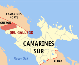
Del Gallego, officially the Municipality of Del Gallego, is a 4th class municipality in the province of Camarines Sur, Philippines. According to the 2020 census, it has a population of 26,403 people.

<span class="mw-page-title-main">Gainza</span> Municipality in Camarines Sur, Philippines

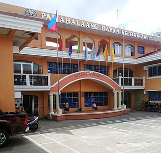
Gainza, officially the Municipality of Gainza, is a 5th class municipality in the province of Camarines Sur, Philippines. According to the 2020 census, it has a population of 11,584 people.

<span class="mw-page-title-main">Garchitorena</span> Municipality in Camarines Sur, Philippines

Garchitorena, officially the Municipality of Garchitorena, is a 4th class municipality in the province of Camarines Sur, Philippines. According to the 2020 census, it has a population of 29,436 people.

<span class="mw-page-title-main">Lupi, Camarines Sur</span> Municipality in Camarines Sur, Philippines

Lupi, officially the Municipality of Lupi, is a 3rd class municipality in the province of Camarines Sur, Philippines. According to the 2020 census, it has a population of 33,897 people.

<span class="mw-page-title-main">Magarao</span> Municipality in Camarines Sur, Philippines

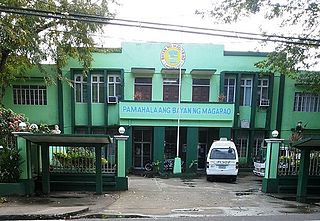
Magarao, officially the Municipality of Magarao, is a 3rd class municipality in the province of Camarines Sur, Philippines. According to the 2020 census, it has a population of 26,742 people.

<span class="mw-page-title-main">Milaor</span> Municipality in Camarines Sur, Philippines

Milaor, officially the Municipality of Milaor, is a 3rd class municipality in the province of Camarines Sur, Philippines. According to the 2020 census, it has a population of 33,963 people.

<span class="mw-page-title-main">Ocampo, Camarines Sur</span> Municipality in Camarines Sur, Philippines

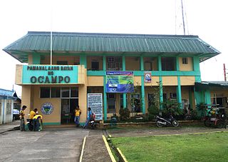
Ocampo, officially the Municipality of Ocampo, is a 1st class municipality in the province of Camarines Sur, Philippines. According to the 2020 census, it has a population of 51,073 people.

<span class="mw-page-title-main">Pamplona, Camarines Sur</span> Municipality in Camarines Sur, Philippines

Pamplona, officially the Municipality of Pamplona, is a 3rd class municipality in the province of Camarines Sur, Philippines. According to the 2020 census, it has a population of 39,333 people.

<span class="mw-page-title-main">Pili, Camarines Sur</span> Capital of Camarines Sur, Philippines

Pili, officially the Municipality of Pili is a 1st class municipality and capital of the province of Camarines Sur, Philippines. According to the 2020 census, it has a population of 99,196 people.

<span class="mw-page-title-main">Ragay</span> Municipality in Camarines Sur, Philippines

Ragay, officially the Municipality of Ragay, is a 1st class municipality in the province of Camarines Sur, Philippines. According to the 2020 census, it has a population of 59,770 people.

<span class="mw-page-title-main">Sagñay</span> Municipality in Camarines Sur, Philippines

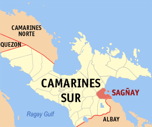
Sagñay, [ˈsaŋaj], officially the Municipality of Sagñay, is a 4th class municipality in the province of Camarines Sur in the Philippines. According to the 2020 census, it has a population of 36,841 people.

<span class="mw-page-title-main">San Fernando, Camarines Sur</span> Municipality in Camarines Sur, Philippines

San Fernando, officially the Municipality of San Fernando, is a 2nd class municipality in the province of Camarines Sur, Philippines. According to the 2020 census, it has a population of 38,626 people.

<span class="mw-page-title-main">Sipocot</span> Municipality in Camarines Sur, Philippines

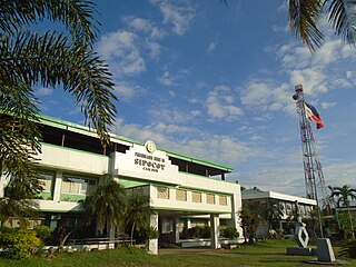
Sipocot, officially the Municipality of Sipocot, is a 1st class municipality in the province of Camarines Sur, Philippines. According to the 2020 census, it has a population of 68,169 people.

<span class="mw-page-title-main">Tinambac</span> Municipality in Camarines Sur, Philippines

Tinambac, officially the Municipality of Tinambac, is a 1st class municipality in the province of Camarines Sur, Philippines. According to the 2020 census, it has a population of 70,176 people.

References

  1. Municipality of Minalabac | (DILG)
  2. "2015 Census of Population, Report No. 3 – Population, Land Area, and Population Density" (PDF). Philippine Statistics Authority. Quezon City, Philippines. August 2016. ISSN   0117-1453. Archived (PDF) from the original on May 25, 2021. Retrieved July 16, 2021.
  3. 1 2 3 Census of Population (2020). "Region V (Bicol Region)". Total Population by Province, City, Municipality and Barangay. Philippine Statistics Authority . Retrieved 8 July 2021.
  4. "PSA Releases the 2018 Municipal and City Level Poverty Estimates". Philippine Statistics Authority. 15 December 2021. Retrieved 22 January 2022.
  5. "Minalabac, Camarines Sur: Average Temperatures and Rainfall". World Weather Online. Retrieved 29 October 2017.
  6. Census of Population (2015). "Region V (Bicol Region)". Total Population by Province, City, Municipality and Barangay. Philippine Statistics Authority . Retrieved 20 June 2016.
  7. Census of Population and Housing (2010). "Region V (Bicol Region)". Total Population by Province, City, Municipality and Barangay. National Statistics Office . Retrieved 29 June 2016.
  8. Censuses of Population (1903–2007). "Region V (Bicol Region)". Table 1. Population Enumerated in Various Censuses by Province/Highly Urbanized City: 1903 to 2007. National Statistics Office.
  9. "Province of Camarines Sur". Municipality Population Data. Local Water Utilities Administration Research Division. Retrieved 17 December 2016.
  10. "Poverty incidence (PI):". Philippine Statistics Authority. Retrieved December 28, 2020.
  11. Error: Unable to display the reference properly. See the documentation for details.
  12. Error: Unable to display the reference properly. See the documentation for details.
  13. Error: Unable to display the reference properly. See the documentation for details.
  14. Error: Unable to display the reference properly. See the documentation for details.
  15. Error: Unable to display the reference properly. See the documentation for details.
  16. "PSA Releases the 2018 Municipal and City Level Poverty Estimates". Philippine Statistics Authority. 15 December 2021. Retrieved 22 January 2022.
  17. "2019 National and Local Elections" (PDF). Commission on Elections. Retrieved March 25, 2022.{{cite web}}: CS1 maint: url-status (link)