Guinobatan

Last updated

Guinobatan
Municipality of Guinobatan
Our Lady of Assumption Church Guinobatan (S. Ciencia) - Flickr.jpg
Our Lady of the Assumption Church of Guinobatan
Flag of Guinobatan, Albay.png
Guinobatan Albay.png
Nickname: 
The Sparkling Gem of Bicol
Ph locator albay guinobatan.png
Map of Albay with Guinobatan highlighted
OpenStreetMap
Guinobatan
Philippines location map (square).svg
Red pog.svg
Guinobatan
Location within the Philippines
Coordinates: 13°11′N123°36′E / 13.18°N 123.6°E / 13.18; 123.6
Country Philippines
Region Bicol Region
Province Albay
District 3rd district
Founded 1688
Founded byDon Francisco Bagamasbad
Barangays 44 (see Barangays)
Government
[1]
  Type Sangguniang Bayan
   Mayor Paul "Chino" N. Garcia
   Vice Mayor Ann "Gemma" Y. Ongjoco
   Representative Fernando T. Cabredo
   Municipal Council
Members
   Electorate 58,205 voters (2022)
Area
[2]
  Total244.43 km2 (94.37 sq mi)
Elevation
169 m (554 ft)
Highest elevation
474 m (1,555 ft)
Lowest elevation
59 m (194 ft)
Population
 (2020 census) [3]
  Total85,786
  Density350/km2 (910/sq mi)
   Households
20,327
Demonym Guinobateño/ Guinobatanon
Economy
   Income class 1st municipal income class
   Poverty incidence
25.61
% (2018) [4]
   Revenue 273.4 million (2020)
   Assets 814.1 million (2020)
   Expenditure 263.6 million (2020)
   Liabilities 249.1 million (2020)
Service provider
  ElectricityAlbay Power and Energy Corporation (APEC)
  WaterGuinobatan Water District
Time zone UTC+8 (PST)
ZIP code
4503
PSGC
IDD : area code +63(0)52
Native languages Tagalog, East Miraya
Feast dateAugust 15
Catholic dioceseDiocese of Legazpi
Patron saintNuestra Señora de la Asuncion
Website www.guinobatan.gov.ph

Guinobatan, officially the Municipality of Guinobatan (Central Bikol : Banwaan kan Guinobatan; Tagalog : Bayan ng Guinobatan), is a 1st class municipality in the province of Albay, Philippines. According to the 2020 census, it has a population of 85,786 people. [3]

Contents

The town is the birthplace of General Simeón Ola, the last Filipino general to surrender to the Americans after the Philippine–American War.

History

Legend

In the research work "Guinobatan Through the Times," the following version of the legend is stated:

Some versions also state that the town's name is derived from Ginabutan, meaning "a place where trees or plants were uprooted." [6]

History under foreign rule

Luis Née, a botanist, reached Bicol in January 1792, accompanying the expedition of Capt. Alejandro Malaspina. Née explored towns near Mayon and including the area now known as Guinobatan. He noted that "trees grew in exuberance making the foothills impenetrable in many parts." [7]

Dr. Leonilo R. Palacio of Guinobatan's Republic Colleges mentioned in an essay entitled "Guinobatan and its Church" that "in 1672, the Parish of Guinobatan was already mentioned in books as a visita of the Municipality of Camalig." [8]

In 1890, the title of the gobernadorcillo was changed to Capitan Municipal. The Municipal Law of 1894 guaranteed that the term of the local executive would be extended from two years to four years. Also among the salient provisions of the law was the election of 12 vocales, equivalent to today's councilors. In 1895, the Colegio de San Buenaventura was also built, making Guinobatan the centre for higher education in Albay. [5]

Cabezas and principales elected the gobernadorcillo until 1863. Until 1847, Guinobatan belonged to Camarines. During the said year, the towns of Quipia, Camalig and Donsol (now in Sorsogon) were ceded to Albay, in exchange for the towns of the Partido de Lagonoy. From 1730 to 1818, the town transferred from one place to another. In 1730, it was on a site now called Binanuahan. From there, it was the relocated to Bubulusan. During the eruption of 1814, citizens opted to evacuate to higher ground, in Mauraro.

American colonization

During the Philippine Revolution and the Philippine–American War (1898-1911), most of the schoolhouses built by the Spaniards were destroyed by constant artillery fire, most of which came from the Americans. As part of the "pacification" campaign of the Americans, engineers and architects were sent to the Philippines to oversee the construction of public works. Engr. Edward K. Bourne and famed urban planner Daniel Burnham, among other American architects and engineers, were instructed to go to Manila. In response, the Philippine Commission passed Act No. 268 which created the Bureau of Architecture and Construction of Public Buildings. Mr. Bourne was appointed as its head. In 1907, the Philippine Assembly was formed. Angel Roco of Mauraro, Guinobatan represented Albay in the Assembly. The same year, Assemblyman Isauro Gabaldon of Nueva Ecija authored an act which appropriated 1 million between 1907 and 1915 for "construction of schoolhouses of strong materials in barrios with guaranteed daily attendance of not less than sixty pupils…" Passing into law as Act No. 1801, the act became known as the "Gabaldon Act". Among the salient provisions was that no school could receive more than 4,000 unless the municipality to which the school belonged contributed at least 50% of the total amount granted to the school by the Gabaldon Act. The Gabaldon Act stipulated that only on land owned by the municipality could schools be constructed. Fifty-one "Gabaldons" were completed by 1911, and by 1916, four hundred five more were constructed. Among those completed between 1911 and 1916 was Guinobatan Central School blg. 1 or the Guinobatan East Central School's Gabaldon Building.

Potenciano Gregorio's Bikol language musical composition "Sarung Banggi" premiered at the town fiesta in Guinobatan in August 1910. [9]

Geography

According to the Philippine Statistics Authority, the municipality has a land area of 244.43 square kilometres (94.37 sq mi) [10] constituting

The town of Guinobatan is located at 13°11′N123°36′E / 13.18°N 123.6°E / 13.18; 123.6 . The territory of Guinobatan is bordered by a number of municipalities: Camalig on the east, Jovellar on the south, Pio Duran on the south-west, Ligao on the north-west. On the north-east, the town shares with Malilipot, Santo Domingo, Daraga, Tabaco and Legazpi, a common point in the crater of Mayon Volcano. [5] Guinobatan is 17 kilometres (11 mi) from Legazpi City and 510 kilometres (320 mi) from Manila.

Barangays

Guinobatan is politically subdivided into 44 barangays. [11] Each barangay consists of puroks and some have sitios.

PSGC Barangay Population ±% p.a.
2020 [3] 2010 [12]
050504001 Agpay 0.6% 482 451 0.67%
050504002 Balite 0.7% 585 524 1.11%
050504003 Banao 1.3% 1,074 1,018 0.54%
050504004 Batbat 1.6% 1,373 1,314 0.44%
050504005 Binogsacan Lower 2.2% 1,889 1,716 0.96%
050504049 Binogsacan Upper 1.3% 1,131 1,067 0.58%
050504006 Bololo 1.7% 1,442 1,363 0.56%
050504007 Bubulusan 1.6% 1,399 1,189 1.64%
050504009 Calzada 3.2% 2,787 2,662 0.46%
050504010 Catomag 0.9% 796 713 1.11%
050504011 Doña Mercedes 1.6% 1,411 1,472 −0.42%
050504012 Doña Tomasa (Magatol) 1.6% 1,352 1,197 1.22%
050504013 Ilawod 2.6% 2,209 2,101 0.50%
050504015 Inamnan Grande 2.5% 2,177 1,986 0.92%
050504014 Inamnan Pequeño 2.0% 1,756 1,636 0.71%
050504016 Inascan 1.7% 1,481 1,359 0.86%
050504017 Iraya 2.1% 1,771 2,006 −1.24%
050504018 Lomacao 2.4% 2,096 2,002 0.46%
050504021 Maguiron 2.5% 2,118 2,110 0.04%
050504022 Maipon 4.6% 3,944 2,214 5.94%
050504023 Malabnig 1.3% 1,145 1,117 0.25%
050504024 Malipo 2.1% 1,760 1,690 0.41%
050504025 Malobago 2.2% 1,867 1,818 0.27%
050504026 Maninila 1.7% 1,482 1,437 0.31%
050504027 Mapaco 1.7% 1,460 1,463 −0.02%
050504008 Marcial O. Rañola (Cabaloaon) 0.6% 537 633 −1.63%
050504029 Masarawag 4.4% 3,760 3,553 0.57%
050504030 Mauraro 7.0% 5,980 5,145 1.52%
050504031 Minto 2.0% 1,726 1,707 0.11%
050504032 Morera 3.0% 2,602 1,878 3.31%
050504034 Muladbucad Grande 2.4% 2,079 2,010 0.34%
050504033 Muladbucad Pequeño 2.4% 2,051 1,920 0.66%
050504035 Ongo 1.1% 942 930 0.13%
050504036 Palanas 0.5% 427 736 −5.30%
050504038 Poblacion 1.6% 1,336 1,352 −0.12%
050504040 Pood 0.7% 583 287 7.34%
050504042 Quibongbongan 3.0% 2,595 2,286 1.28%
050504041 Quitago 2.6% 2,236 1,760 2.42%
050504043 San Francisco 3.8% 3,302 2,909 1.28%
050504044 San Jose (Ogsong) 1.0% 853 721 1.70%
050504045 San Rafael 4.5% 3,884 3,880 0.01%
050504046 Sinungtan 1.5% 1,312 1,398 −0.63%
050504047 Tandarora 1.5% 1,291 1,399 −0.80%
050504048 Travesia 4.5% 3,878 3,838 0.10%
Total85,78675,9671.22%

Climate

Climate data for Guinobatan, Albay
MonthJanFebMarAprMayJunJulAugSepOctNovDecYear
Mean daily maximum °C (°F)26
(79)
27
(81)
28
(82)
30
(86)
30
(86)
30
(86)
29
(84)
29
(84)
29
(84)
28
(82)
28
(82)
27
(81)
28
(83)
Mean daily minimum °C (°F)22
(72)
22
(72)
22
(72)
23
(73)
24
(75)
25
(77)
24
(75)
24
(75)
24
(75)
24
(75)
23
(73)
23
(73)
23
(74)
Average precipitation mm (inches)138
(5.4)
83
(3.3)
74
(2.9)
50
(2.0)
108
(4.3)
165
(6.5)
202
(8.0)
165
(6.5)
190
(7.5)
186
(7.3)
188
(7.4)
183
(7.2)
1,732
(68.3)
Average rainy days16.811.913.513.820.525.227.426.226.124.720.718.5245.3
Source: Meteoblue [13]

Demographics

Population census of Guinobatan
YearPop.±% p.a.
1903 20,027    
1918 25,113+1.52%
1939 26,419+0.24%
1948 32,280+2.25%
1960 48,157+3.39%
1970 47,190−0.20%
1975 49,724+1.05%
1980 53,639+1.53%
1990 59,187+0.99%
1995 65,512+1.92%
2000 71,071+1.76%
2007 74,386+0.63%
2010 75,967+0.77%
2015 82,361+1.55%
2020 85,786+0.80%
Source: Philippine Statistics Authority [14] [12] [15] [16]

In the 2020 census, Guinobatan had a population of 85,786. [3] The population density was 350 inhabitants per square kilometre (910/sq mi).

Economy

Culture

Guinobatan Museum Guinobatan Museum (National Road, Guinobatan, Albay; 04-16-2023).jpg
Guinobatan Museum

Guinobatan hosts an annual festival in the celebration of Our Lady of Assumption, its patron saint. Until 2013, the town festival was called "Arandurugan Festival." In August 2013, Guinobatan celebrated Longganisa Festival, named after the local product which is listed under the Department of Trade and Industry's "One Town, One Product" program.

Notable Personalities

Related Research Articles

<span class="mw-page-title-main">Albay</span> Province in Bicol, Philippines

Albay, officially the Province of Albay, is a province in the Bicol Region of the Philippines, mostly on the southeastern part of the island of Luzon. Its capital is the city of Legazpi, the regional center of the whole Bicol Region, which is located in the southern foothill of Mayon Volcano.

<span class="mw-page-title-main">Camarines Sur</span> Province in Bicol, Philippines

Camarines Sur, officially the Province of Camarines Sur, is a province in the Philippines located in the Bicol Region on Luzon. Its capital is Pili and the province borders Camarines Norte and Quezon to the northwest, and Albay to the south. To the east lies the island province of Catanduanes across the Maqueda Channel.

<span class="mw-page-title-main">Legazpi, Albay</span> Capital and largest city of Albay, Philippines

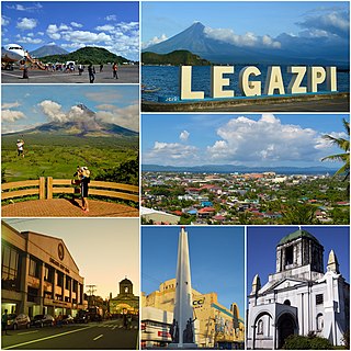
Legazpi, officially the City of Legazpi, is a 1st class component city and capital of the province of Albay, Philippines. According to the 2020 census, it has a population of 209,533. Legazpi is the regional center and largest city of the Bicol Region, in terms of population. It is the region's center of tourism, education, health services, commerce and transportation in the Bicol Region.

<span class="mw-page-title-main">Tabaco</span> Component city in Albay, Philippines

Tabaco, officially the City of Tabaco, is a 4th class component city in the province of Albay, Philippines. According to the 2020 census, it has a population of 140,961 people.

<span class="mw-page-title-main">Claveria, Masbate</span> Municipality in Masbate, Philippines

Claveria, officially the Municipality of Claveria, is a 3rd class municipality in the province of Masbate, Philippines. According to the 2020 census, it has a population of 42,142 people. Ranked 592nd among 1,488 municipalities in the Philippines.

<span class="mw-page-title-main">Oas, Albay</span> Municipality in Albay, Philippines

Oas, officially the Municipality of Oas, is a 1st class municipality in the province of Albay, Philippines. According to the 2020 census, it has a population of 66,084 people.

<span class="mw-page-title-main">Jovellar</span> Municipality in Albay, Philippines

Jovellar, officially the Municipality of Jovellar, is a 4th class municipality in the province of Albay, Philippines. According to the 2020 census, it has a population of 17,795 people.

<span class="mw-page-title-main">Bacacay</span> Municipality in Albay, Philippines

Bacacay, officially the Municipality of Bacacay, is a 2nd class municipality in the province of Albay, Philippines. According to the 2020 census, it has a population of 72,485 people. Bacacay is primarily an agricultural town and abundant in seafood.

<span class="mw-page-title-main">Camalig</span> Municipality in Albay, Philippines

Camalig, officially the Municipality of Camalig, is a 1st class municipality in the province of Albay, Philippines. According to the 2020 census, it had a population of 72,042 people. It is known for one of Bicol's finest delicacy, Pinangat.

<span class="mw-page-title-main">Daraga</span> Municipality in Albay, Philippines

Daraga, officially the Municipality of Daraga, is a 1st class municipality in the province of Albay, Philippines. According to the 2020 census, it has a population of 133,893.

<span class="mw-page-title-main">Malilipot</span> Municipality in Albay, Philippines

Malilipot, officially the Municipality of Malilipot, is a 4th class municipality in the province of Albay, Philippines. According to the 2020 census, it has a population of 40,857 people.

<span class="mw-page-title-main">Malinao, Albay</span> Municipality in Albay, Philippines

Malinao, officially the Municipality of Malinao, is a 3rd class municipality in the province of Albay, Philippines. According to the 2020 census, it has a population of 47,395 people.

<span class="mw-page-title-main">Manito, Albay</span> Municipality in Albay, Philippines

Manito, officially the Municipality of Manito, is a 4th class municipality in the province of Albay, Philippines. According to the 2020 census, it has a population of 26,162.

<span class="mw-page-title-main">Pio Duran</span> Municipality in Albay, Philippines

Pio Duran, officially the Municipality of Pio Duran, is a 3rd class municipality in the province of Albay, Philippines. According to the 2020 census, it has a population of 49,070 people.

<span class="mw-page-title-main">Santo Domingo, Albay</span> Municipality in Albay, Philippines

Santo Domingo, officially the Municipality of Santo Domingo,, is a 4th class municipality in the province of Albay, Philippines. According to the 2020 census, it has a population of 37,765 people.

<span class="mw-page-title-main">Tiwi, Albay</span> Municipality in Albay, Philippines

Tiwi, officially the Municipality of Tiwi is a 1st class municipality in the Province of Albay, Philippines. According to the 2020 census, it has a population of 56,444 people.

<span class="mw-page-title-main">Ligao</span> Component city in Albay, Philippines

Ligao, officially the City of Ligao, is a 4th class component city in the province of Albay, Philippines. According to the 2020 census, it has a population of 118,096 people. Most of the city's economy came from agriculture sector.

<span class="mw-page-title-main">San Lorenzo Ruiz, Camarines Norte</span> Municipality in Camarines Norte, Philippines

San Lorenzo Ruiz, officially the Municipality of San Lorenzo Ruiz, is a 5th class municipality in the province of Camarines Norte, Philippines. According to the 2020 census, it has a population of 15,757 people.

<span class="mw-page-title-main">Bulusan (municipality)</span> Municipality in Sorsogon, Philippines

Bulusan, officially the Municipality of Bulusan, is a 4th class municipality in the province of Sorsogon, Philippines. According to the 2020 census, it has a population of 23,932 people.

<span class="mw-page-title-main">Aroroy</span> Municipality in Masbate, Philippines

Aroroy, officially the Municipality of Aroroy, is a 1st class municipality in the province of Masbate, Philippines. According to the 2020 census, it has a population of 88,351 people. The town is known for the Kalanay Cave, one of the most important archaeological sites in Masbate province.

References

  1. Municipality of Guinobatan | (DILG)
  2. "2015 Census of Population, Report No. 3 – Population, Land Area, and Population Density" (PDF). Philippine Statistics Authority. Quezon City, Philippines. August 2016. ISSN   0117-1453. Archived (PDF) from the original on May 25, 2021. Retrieved July 16, 2021.
  3. 1 2 3 4 Census of Population (2020). "Region V (Bicol Region)". Total Population by Province, City, Municipality and Barangay. Philippine Statistics Authority . Retrieved July 8, 2021.
  4. "PSA Releases the 2018 Municipal and City Level Poverty Estimates". Philippine Statistics Authority. December 15, 2021. Retrieved January 22, 2022.
  5. 1 2 3 Dy and Tuson, 2012. Guinobatan Through the Times: Essays on Our Heritage. Marcial O. Rañola Memorial School
  6. Municipality of Guinobatan. 1996. Arandurugan Festival Souvenir Program: Guinobatan, Albay
  7. Mallari, Francisco, S.J. 1999. Vignettes of Bicol History. Quezon City: New DayPublishers
  8. Dy and Tuson. 2012. Guinobatan Through the Times. Marcial O. Rañola Memorial School
  9. Tariman, Pablo (June 3, 2013). "Bicolandia's Sarung Banggi: From music to film". The Philippine Star. Philstar Global Corp. Retrieved February 5, 2019.
  10. "Province: Albay". PSGC Interactive. Quezon City, Philippines: Philippine Statistics Authority . Retrieved November 12, 2016.
  11. "Municipal: Guinobatan". PSGC Interactive. Quezon City, Philippines: Philippine Statistics Authority . Retrieved January 8, 2016.
  12. 1 2 Census of Population and Housing (2010). "Region V (Bicol Region)" (PDF). Total Population by Province, City, Municipality and Barangay. National Statistics Office . Retrieved June 29, 2016.
  13. "Guinobatan, Albay : Average Temperatures and Rainfall". Meteoblue. Retrieved December 29, 2018.
  14. Census of Population (2015). "Region V (Bicol Region)". Total Population by Province, City, Municipality and Barangay. Philippine Statistics Authority . Retrieved June 20, 2016.
  15. Censuses of Population (1903–2007). "Region V (Bicol Region)". Table 1. Population Enumerated in Various Censuses by Province/Highly Urbanized City: 1903 to 2007. National Statistics Office.{{cite encyclopedia}}: CS1 maint: numeric names: authors list (link)
  16. "Province of Albay". Municipality Population Data. Local Water Utilities Administration Research Division. Retrieved December 17, 2016.
  17. "Poverty incidence (PI):". Philippine Statistics Authority. Retrieved December 28, 2020.
  18. "Estimation of Local Poverty in the Philippines" (PDF). Philippine Statistics Authority. November 29, 2005.
  19. "2003 City and Municipal Level Poverty Estimates" (PDF). Philippine Statistics Authority. March 23, 2009.
  20. "City and Municipal Level Poverty Estimates; 2006 and 2009" (PDF). Philippine Statistics Authority. August 3, 2012.
  21. "2012 Municipal and City Level Poverty Estimates" (PDF). Philippine Statistics Authority. May 31, 2016.
  22. "Municipal and City Level Small Area Poverty Estimates; 2009, 2012 and 2015". Philippine Statistics Authority. July 10, 2019.
  23. "PSA Releases the 2018 Municipal and City Level Poverty Estimates". Philippine Statistics Authority. December 15, 2021. Retrieved January 22, 2022.