Umingan

Last updated

Umingan
Municipality of Umingan
Uminganjf5271 07.JPG
Downtown area
Umingan Pangasinan.png
Ph locator pangasinan umingan.png
Map of Pangasinan with Umingan highlighted
OpenStreetMap
Umingan
Philippines location map (square).svg
Red pog.svg
Umingan
Location within the Philippines
Coordinates: 15°55′44″N120°50′31″E / 15.9289°N 120.8419°E / 15.9289; 120.8419
Country Philippines
Region Ilocos Region
Province Pangasinan
District 6th district
Founded May 5, 1843
Barangays 58 (see Barangays)
Government
[1]
  Type Sangguniang Bayan
   Mayor Michael M. Cruz (NP)
   Vice Mayor Chris Evert B.Tadeo-Leynes (API)
   Representative Marlyn L.Primicias-Agabas
   Municipal Council
Members
   Electorate 56,259 voters (2022)
Area
[2]
  Total258.43 km2 (99.78 sq mi)
Elevation
115 m (377 ft)
Highest elevation
561 m (1,841 ft)
Lowest elevation
70 m (230 ft)
Population
 (2020 census) [3]
  Total77,074
  Density300/km2 (770/sq mi)
   Households
20,380
Economy
   Income class 1st municipal income class
   Poverty incidence
18.99
% (2021) [4]
   Revenue 249.8 million (2020)
   Assets 457.1 million (2020)
   Expenditure 257.3 million (2020)
   Liabilities 73.01 million (2020)
Service provider
  ElectricityPangasinan 3 Electric Cooperative (PANELCO 3)
Time zone UTC+8 (PST)
ZIP code
2443
PSGC
IDD : area code +63(0)75
Native languages Pangasinan
Ilocano
Tagalog
Website www.umingan.gov.ph

Umingan, officially the Municipality of Umingan (Pangasinan : Baley na Umingan; Ilocano : Ili ti Umingan; Tagalog : Bayan ng Umingan), is a 1st class municipality in the province of Pangasinan, Philippines. According to the 2020 census, it has a population of 77,074 people. [3]

Contents

Umingan is 79 kilometres (49 mi) from Lingayen, 67 kilometres (42 mi) from Cabanatuan, and 195 kilometres (121 mi) from Manila.

Geography

Barangays

Umingan is politically subdivided into 58 barangays. Each barangay consists of puroks and some have sitios.

  • Abot Molina
  • Alo-o
  • Amaronan
  • Annam (San Felipe)
  • Bantug
  • Baracbac
  • Barat
  • Buenavista
  • Cabalitian
  • Cabangaran
  • Cabaruan
  • Cabatuan
  • Cadiz
  • Calitlitan
  • Capas
  • Carayungan Sur
  • Carosalesan
  • Casilan
  • Caurdanetaan
  • Concepcion
  • Decreto
  • Diaz
  • Del Rosario (Trienta y Siete)
  • Diket
  • Don Justo Abalos (Caroan)
  • Don Montano (Cadamortisan)
  • Esperanza
  • Evangelista
  • Flores
  • Fulgosino
  • Gonzales (Carayungan)
  • La Paz
  • Labuan
  • Lauren
  • Lubong
  • Luna Weste
  • Luna Este
  • Mantacdang
  • Maseil-seil
  • Nampalcan
  • Nancalabasaan
  • Pangangaan
  • Papallasen
  • Pemienta
  • Poblacion East
  • Poblacion West
  • Prado
  • Resurreccion
  • Ricos
  • San Andres (Parang)
  • San Juan
  • San Leon
  • San Pablo
  • San Vicente
  • Santa Maria
  • Santa Rosa
  • Sinabaan (Mondragon)
  • Tanggal Sawang

Climate

Climate data for Umingan, Pangasinan
MonthJanFebMarAprMayJunJulAugSepOctNovDecYear
Mean daily maximum °C (°F)31
(88)
31
(88)
32
(90)
34
(93)
35
(95)
34
(93)
32
(90)
32
(90)
32
(90)
32
(90)
32
(90)
31
(88)
32
(90)
Mean daily minimum °C (°F)22
(72)
22
(72)
22
(72)
24
(75)
24
(75)
24
(75)
24
(75)
24
(75)
24
(75)
23
(73)
23
(73)
22
(72)
23
(74)
Average precipitation mm (inches)13.6
(0.54)
10.4
(0.41)
18.2
(0.72)
15.7
(0.62)
178.4
(7.02)
227.9
(8.97)
368
(14.5)
306.6
(12.07)
310.6
(12.23)
215.7
(8.49)
70.3
(2.77)
31.1
(1.22)
1,766.5
(69.56)
Average rainy days3224141623212415106140
Source: World Weather Online [5]

Demographics

Population census of Umingan
YearPop.±% p.a.
1903 5,761    
1918 16,356+7.20%
1939 24,960+2.03%
1948 29,729+1.96%
1960 30,664+0.26%
1970 36,135+1.65%
1975 40,880+2.51%
1980 41,364+0.24%
1990 48,003+1.50%
1995 51,693+1.40%
2000 58,603+2.73%
2007 62,497+0.89%
2010 67,534+2.86%
2015 73,252+1.56%
2020 77,074+1.01%
Source: Philippine Statistics Authority [6] [7] [8] [9]

97% of the residents of Umingan are descendants of Ilocano settlers from different areas of Ilocos Region, the remaining 3% are descendants of residents from central and coastal areas of Pangasinan, Tagalog settlers from Tagalog areas, most likely south Nueva Ecija and Bulacan, and Kapampangan settlers. [10] [ unreliable source? ]

Economy

Poverty Incidence of Umingan

10
20
30
40
2006
38.50
2009
22.90
2012
21.64
2015
12.53
2018
12.82
2021
18.99

Source: Philippine Statistics Authority [11] [12] [13] [14] [15] [16] [17] [18]

The town is a major producer of squash (kalabasa).[ further explanation needed ]

Government

Local government

Umingan Town Hall UminganHalljf5079 14.JPG
Umingan Town Hall

Umigan, belonging to the sixth congressional district of the province of Pangasinan, is governed by a mayor designated as its local chief executive and by a municipal council as its legislative body in accordance with the Local Government Code. The mayor, vice mayor, and the councilors are elected directly by the people through an election which is being held every three years.

Elected officials

Members of the Municipal Council
(2022–2025) [19]
PositionName
CongressmanMarlyn L. Primicias-Agabas
MayorMichael Carleone M. Cruz
Vice-MayorChris Evert T. Leynes
CouncilorsJonathan H. Navalta
Cesario B. Galleguez
Alain Jermen Rabang
Fred Fernandez
Mar Lee Non Sonaco
Jay-ar O. Paz
Onyok Onia
Maya Membrere

Education

Elementary schools

Secondary schools

Tertiary schools

Private institutions:

Related Research Articles

<span class="mw-page-title-main">Binmaley</span> Municipality in Pangasinan, Philippines

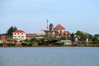
Binmaley, officially the Municipality of Binmaley, is a 1st class municipality in the province of Pangasinan, Philippines. According to the 2020 census, it has a population of 86,881 people.

<span class="mw-page-title-main">Anda, Pangasinan</span> Municipality in Pangasinan, Philippines

Anda, officially the Municipality of Anda, is a 3rd class municipality in the province of Pangasinan, Philippines. Unique in this part of the province, The Sambalic language of Bolinao or Binubolinao is primarily spoken in the municipality and the adjacent town of Bolinao. According to the 2020 census, it has a population of 41,548 people.

<span class="mw-page-title-main">Villasis</span> Municipality in Pangasinan, Philippines

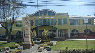
Villasis, officially the Municipality of Villasis, is a 1st class municipality in the province of Pangasinan, Philippines. According to the 2020 census, it has a population of 65,047 people.

<span class="mw-page-title-main">Agno, Pangasinan</span> Municipality in Pangasinan, Philippines

Agno, officially the Municipality of Agno, is a 3rd class municipality in the province of Pangasinan, Philippines. According to the 2020 census, it has a population of 29,947 people.

<span class="mw-page-title-main">Asingan</span> Municipality in Pangasinan, Philippines

Asingan, officially the Municipality of Asingan, is a 2nd class municipality in the province of Pangasinan, Philippines. According to the 2020 census, it has a population of 57,811 people.

<span class="mw-page-title-main">Balungao</span> Municipality in Pangasinan, Philippines

Balungao, officially the Municipality of Balungao, is a 4th class municipality in the province of Pangasinan, Philippines. According to the 2020 census, it has a population of 30,004 people.

<span class="mw-page-title-main">Bani, Pangasinan</span> Municipality in Pangasinan, Philippines

Bani, officially the Municipality of Bani, is a 2nd class municipality in the province of Pangasinan, Philippines. According to the 2020 census, it has a population of 52,603 people.

<span class="mw-page-title-main">Basista</span> Municipality in Pangasinan, Philippines

Basista, officially the Municipality of Basista, is a 4th class municipality in the province of Pangasinan, Philippines. According to the 2020 census, it has a population of 37,679 people.

<span class="mw-page-title-main">Bolinao</span> Municipality in Pangasinan, Philippines

Bolinao, officially the Municipality of Bolinao, is a 1st class municipality in the province of Pangasinan, Philippines. According to the 2020 census, it has a population of 83,979 people.

<span class="mw-page-title-main">Infanta, Pangasinan</span> Municipality in Pangasinan, Philippines

Infanta, officially the Municipality of Infanta, is a 3rd class municipality in the province of Pangasinan, Philippines. According to the 2020 census, it has a population of 26,242 people.

<span class="mw-page-title-main">Labrador, Pangasinan</span> Municipality in Pangasinan, Philippines

Labrador, officially the Municipality of Labrador, is a 4th class municipality in the province of Pangasinan, Philippines. According to the 2020 census, it has a population of 26,811 people.

<span class="mw-page-title-main">Laoac</span> Municipality in Pangasinan, Philippines

Laoac, officially the Municipality of Laoac, is a 4th class municipality in the province of Pangasinan, Philippines. According to the 2020 census, it has a population of 34,128 people.

<span class="mw-page-title-main">Manaoag</span> Municipality in Pangasinan, Philippines

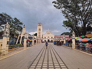
Manaoag, officially the Municipality of Manaoag, is a 1st class municipality in the province of Pangasinan, Philippines. According to the 2020 census, it has a population of 76,045 people.

<span class="mw-page-title-main">San Quintin, Pangasinan</span> Municipality in Pangasinan, Philippines

San Quintin, officially the Municipality of San Quintin, is a 3rd class municipality in the province of Pangasinan, Philippines. According to the 2020 census, it has a population of 33,980 people.

<span class="mw-page-title-main">Santo Tomas, Pangasinan</span> Municipality in Pangasinan, Philippines

Santo Tomas, officially the Municipality of Santo Tomas, is a 5th class municipality in the province of Pangasinan, Philippines. According to the 2020 census, it has a population of 14,878 people, making it the least populated municipality in the province.

<span class="mw-page-title-main">Sual</span> Municipality in Pangasinan, Philippines

Sual, officially the Municipality of Sual, is a 1st class municipality in the province of Pangasinan, Philippines. According to the 2020 census, it has a population of 39,091 people.

<span class="mw-page-title-main">Urbiztondo</span> Municipality in Pangasinan, Philippines

Urbiztondo, officially the Municipality of Urbiztondo, is a 3rd class municipality in the province of Pangasinan, Philippines. According to the 2020 census, it has a population of 55,557 people.

<span class="mw-page-title-main">Anao, Tarlac</span> Municipality in Tarlac, Philippines

Anao, officially the Municipality of Anao, is a 5th class municipality in the province of Tarlac, Philippines. According to the 2020 census, it has a population of 12,208 people, making it the least populated municipality in the province.

<span class="mw-page-title-main">San Manuel, Tarlac</span> Municipality in Tarlac, Philippines

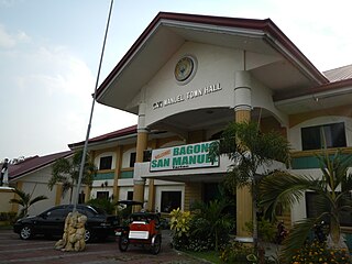
San Manuel, officially the Municipality of San Manuel, is a municipality in the province of Tarlac, Philippines. According to the 2020 census, it has a population of 28,387 people.

<span class="mw-page-title-main">Laur, Nueva Ecija</span> Municipality in Nueva Ecija, Philippines

Laur, officially the Municipality of Laur, is a 3rd class municipality in the province of Nueva Ecija in Central Luzon region of Philippines. According to the 2020 census, it has a population of 38,263 people. Laur is located at the foothills of the Sierra Madre Mountains.

References

  1. Municipality of Umingan | (DILG)
  2. "2015 Census of Population, Report No. 3 – Population, Land Area, and Population Density" (PDF). Philippine Statistics Authority. Quezon City, Philippines. August 2016. ISSN   0117-1453. Archived (PDF) from the original on May 25, 2021. Retrieved July 16, 2021.
  3. 1 2 Census of Population (2020). "Region I (Ilocos Region)". Total Population by Province, City, Municipality and Barangay. Philippine Statistics Authority . Retrieved July 8, 2021.
  4. "PSA Releases the 2021 City and Municipal Level Poverty Estimates". Philippine Statistics Authority. April 2, 2024. Retrieved April 28, 2024.
  5. "Umingan, Pangasinan: Average Temperatures and Rainfall". World Weather Online. Retrieved October 31, 2015.
  6. Census of Population (2015). "Region I (Ilocos Region)". Total Population by Province, City, Municipality and Barangay. Philippine Statistics Authority . Retrieved June 20, 2016.
  7. Census of Population and Housing (2010). "Region I (Ilocos Region)" (PDF). Total Population by Province, City, Municipality and Barangay. National Statistics Office . Retrieved June 29, 2016.
  8. Censuses of Population (1903–2007). "Region I (Ilocos Region)". Table 1. Population Enumerated in Various Censuses by Province/Highly Urbanized City: 1903 to 2007. National Statistics Office.{{cite encyclopedia}}: CS1 maint: numeric names: authors list (link)
  9. "Province of Pangasinan". Municipality Population Data. Local Water Utilities Administration Research Division. Retrieved December 17, 2016.
  10. Umingan History
  11. "Poverty incidence (PI):". Philippine Statistics Authority. Retrieved December 28, 2020.
  12. "Estimation of Local Poverty in the Philippines" (PDF). Philippine Statistics Authority. November 29, 2005.
  13. "2003 City and Municipal Level Poverty Estimates" (PDF). Philippine Statistics Authority. March 23, 2009.
  14. "City and Municipal Level Poverty Estimates; 2006 and 2009" (PDF). Philippine Statistics Authority. August 3, 2012.
  15. "2012 Municipal and City Level Poverty Estimates" (PDF). Philippine Statistics Authority. May 31, 2016.
  16. "Municipal and City Level Small Area Poverty Estimates; 2009, 2012 and 2015". Philippine Statistics Authority. July 10, 2019.
  17. "PSA Releases the 2018 Municipal and City Level Poverty Estimates". Philippine Statistics Authority. December 15, 2021. Retrieved January 22, 2022.
  18. "PSA Releases the 2021 City and Municipal Level Poverty Estimates". Philippine Statistics Authority. April 2, 2024. Retrieved April 28, 2024.
  19. "Umingan - Pangasinan | Eleksyon 2022 | GMA News Online". GMA Integrated News. May 13, 2022. Retrieved June 3, 2024.