Tayug

Last updated
Tayug
Municipality of Tayug
Tayug Municipal Hall.jpg
Tayug Municipal Hall
Flag of Tayug, Pangasinan.png
Tayug Pangasinan.png
Ph locator pangasinan tayug.png
Map of Pangasinan with Tayug highlighted
OpenStreetMap
Tayug
Philippines location map (square).svg
Red pog.svg
Tayug
Location within the Philippines
Coordinates: 16°01′36″N120°44′52″E / 16.02667°N 120.74778°E / 16.02667; 120.74778
CountryPhilippines
Region Ilocos Region
Province Pangasinan
District 6th district
Founded March 17, 1817 (But historical accounts show that Tayug was founded in circa 1759)
Barangays 21 (see Barangays)
Government
[1]
  Type Sangguniang Bayan
   Mayor Atty.Tyrone D.Agabas
   Vice Mayor Lorna Primicias-Tacdol
   Representative Marlyn Primicias Agabas
   Municipal Council
Members
   Electorate 29,526 voters (2022)
Area
[2]
  Total51.24 km2 (19.78 sq mi)
Elevation
[3]
59 m (194 ft)
Highest elevation
108 m (354 ft)
Lowest elevation
43 m (141 ft)
Population
 (2020 census) [4]
  Total45,241
  Density880/km2 (2,300/sq mi)
   Households
12,184
Demonym Tayugenian
Economy
   Income class 3rd municipal income class
   Poverty incidence
8.07
% (2018) [5]
   Revenue 183.3 million (2020)
   Assets 257.2 million (2020)
   Expenditure 153.9 million (2020)
   Liabilities 40.65 million (2020)
Service provider
  ElectricityPangasinan 3 Electric Cooperative (PANELCO 3)
Time zone UTC+8 (PST)
ZIP code
2445
PSGC
IDD : area code +63(0)75
Native languages Pangasinan
Ilocano
Tagalog

Tayug, officially the Municipality of Tayug (Pangasinan : Baley na Tayug; Ilocano : Ili ti Tayug; Tagalog : Bayan ng Tayug), is a 3rd class municipality in the province of Pangasinan, Philippines. According to the 2020 census, it has a population of 45,241 people. [4]

Contents

Tayug is an agricultural municipality producing commercial crops, livestock, and poultry.

Etymology

The town of Tayug got its unique name not from people who were influential or from name of saints but from a very tall tree that once grew in the heart of the town which is believed to be a bakaiau or bacáyao tree (Madhuca betis (Blanco)), an indigenous fruit tree in the Philippines. It was so tall that the people at that time call it "layog [6] " which means "high, towering like the palm trees" in Kapampangan and “very tall; high; towering” in Ilocano.

According to historical accounts, Tayug was formerly a constituent of a sprawling settlement along the upper reaches of the Pampanga River, which is now encompassed within the boundaries of the present-day province of Nueva Ecija. This proximity suggests that the linguistic heritage of the local populace might have been shaped by interactions with Kapampangans.

Over time, due to the locals' difficulty in pronouncing the letter "L," it became commonly replaced with the letter "T" in everyday speech. This linguistic shift eventually resulted in the adoption of the name Tayug.

History

Tayug is an old settlement founded by the Augustinians who were administering what was then called Upper Pampanga, which later became the province of Nueva Ecija. The exact date of its foundation is not clearly known, but it must have been at the start of 18th century, because according to a book of baptism of the town of Asingan, an Augustinian priest was already mission work at that time in Tayug and San Nicolas. A chronicle of the convents and towns founded by Augustinian Order, Biblioteca Historíca Filipina, Volume 4, [7] mentions 1759 as the year of its foundation, while a document dated in Retiro, 19 December 1742, and signed by King Philip V of Spain, mentions Tayug as one of those place which owed their existence to the Augustinian missionaries. [8]

Tayug was first officially organized as a municipality in the province of Nueva Ecija on February 4, 1817.  In 1837, Tayug was ceded to the province of Pangasinan. In 1851, it was once again incorporated with the Province of Nueva Ecija. The town was finally ceded to Pangasinan for the last time in 1864 after decades of uncertainty.

On January 12, 1931, an undercover collective of peasants known as the Philippine National Association, under the leadership of Pedro Calosa, launched an assault against the governing authorities. Their objectives were to assert independence from American governance, denounce societal injustices and economic disparities, and affirm the authority of the Aglipayan Church. Taking control of significant sites including the municipal hall and the Philippine Constabulary's command station, they also set fire to the residences of prominent figures and various structures. The uprising commenced before dawn and was swiftly suppressed by evening, marking a brief yet impactful challenge to colonial authority. A monument paying tribute to Pedro Calosa is situated at the intersection of Pangasinan-Nueva Vizcaya Road and Tayug-San Quintin Road, symbolizing the historical significance of the revolt.

Amid World War II, the town spearheaded a guerrilla assault against the Japanese Imperial Army, marking one of the earliest instances of resistance in the nation. Under the leadership of Lieutenant Severino Antiporda, they successfully expelled the invaders from the fortress and reclaimed the municipal hall on April 14, 1942. However, when the Japanese forces reappeared on May 3, 1942, their defense endured for more than a week before they ultimately surrendered. Subsequently, they, along with individuals suspected of supporting their cause, were executed.

The shifts in colonial governance during the Spanish colonial period, the uprisings under American occupation, and the resistance movements during the Japanese occupation reflect the dynamic history of Tayug. Through these tumultuous times, Tayug would have navigated the changing landscape, adapting to new circumstances and contributing to its distinct historical and cultural identity within the province of Pangasinan.

Geography

Tayug is landlocked municipality located in the eastern part of the province of Pangasinan with neighboring towns of San Manuel and San Nicolas to the North, Natividad to the east, Asingan and Santa Maria to the west, and San Quintin to the south. The municipality has a total land area of 51.24 square kilometers which constitutes 0.94% of the province's total land area.

Barangays

Tayug is politically subdivided into 21 barangays. Each barangay consists of puroks and some have sitios.

  • Agno
  • Amistad
  • Barangobong
  • Carriedo
  • C. Lichauco
  • Evangelista (old name: San Flaviano)
  • Guzon (old name: Santa Ana)
  • Lawak
  • Legaspi
  • Libertad
  • Magallanes
  • Panganiban
  • Brgy. Poblacion A
  • Brgy. Poblacion B
  • Brgy. Poblacion C
  • Brgy. Poblacion D
  • Saleng
  • Santo Domingo
  • Toketec
  • Trenchera
  • Zamora (old name: Concordia)

Climate

The climate of Tayug is divided into two seasons, the wet and dry season. The months of June to October are generally termed as the wet season, characterized by rainy days and occasional typhoons, while the days during the dry season of November to May are relatively hot and dry period.

Climate data for Tayug, Pangasinan
MonthJanFebMarAprMayJunJulAugSepOctNovDecYear
Mean daily maximum °C (°F)31
(88)
31
(88)
32
(90)
34
(93)
35
(95)
34
(93)
32
(90)
32
(90)
32
(90)
32
(90)
32
(90)
31
(88)
32
(90)
Mean daily minimum °C (°F)22
(72)
22
(72)
22
(72)
24
(75)
24
(75)
24
(75)
24
(75)
24
(75)
24
(75)
23
(73)
23
(73)
22
(72)
23
(74)
Average precipitation mm (inches)13.6
(0.54)
10.4
(0.41)
18.2
(0.72)
15.7
(0.62)
178.4
(7.02)
227.9
(8.97)
368
(14.5)
306.6
(12.07)
310.6
(12.23)
215.7
(8.49)
70.3
(2.77)
31.1
(1.22)
1,766.5
(69.56)
Average rainy days3224141623212415106140
Source: World Weather Online [9]

Demographics

Tayug town hall and library Tayug,Pangasinanjf9192 09.JPG
Tayug town hall and library

In the 2020 census, Tayug had a population of 45,241. The population density was 883 inhabitants per square kilometer.

Population census of Tayug
YearPop.±% p.a.
1903 10,400    
1918 13,594+1.80%
1939 16,222+0.85%
1948 19,782+2.23%
1960 20,755+0.40%
1970 24,143+1.52%
1975 26,153+1.62%
1980 26,273+0.09%
1990 31,575+1.86%
1995 33,881+1.33%
2000 36,199+1.43%
2007 37,954+0.66%
2010 40,018+1.95%
2015 43,149+1.45%
2020 45,241+0.94%
Source: Philippine Statistics Authority [10] [11] [12] [13]

Economy

Government

Local government

Tayug, belonging to the sixth congressional district of the province of Pangasinan, is governed by a mayor designated as its local chief executive and by a municipal council as its legislative body in accordance with the Local Government Code. The mayor, vice mayor, and the councilors are elected directly by the people through an election which is being held every three years.

Elected officials

Members of the Municipal Council
(2022–2025) [21]
PositionName
CongressmanMarlyn Primicias-Agabas
MayorTyrone D. Agabas
Vice-MayorLorna Primicias-Tacdol
CouncilorsMaritess Aldoc
Michael Dy
Madilyn Cabotaje-Ramirez
Magdalena Erfe-Mangelen
Henry Wards Aquino
Noel Fernando Bince
Samuel Manzano
Vacant [22]

Related Research Articles

<span class="mw-page-title-main">Central Luzon</span> Administrative region of the Philippines

Central Luzon, designated as Region III, is an administrative region in the Philippines, primarily serving to organize the 7 provinces of the vast central plains of the island of Luzon, for administrative convenience. The region contains the largest plain in the country and produces most of the country's rice supply, earning itself the nickname "Rice Granary of the Philippines". Its provinces are: Aurora, Bataan, Bulacan, Nueva Ecija, Pampanga, Tarlac and Zambales. Pangasinan was formerly a province of Central Luzon before President Marcos signed Presidential Decree No. 1, 1972, incorporating it into Ilocos Region. Additionally, the province of Aurora was part of the defunct political region Southern Tagalog when the region was divided into Calabarzon and Mimaropa, upon the issuance of Executive Order No. 103, dated May 17, 2002, by then-President Gloria Macapagal Arroyo, which transferred Aurora to Central Luzon.

<span class="mw-page-title-main">Gapan</span> Component city in Nueva Ecija, Philippines

Gapan, officially the City of Gapan, is a 4th class component city in the province of Nueva Ecija, Philippines. According to the 2020 census, it has a population of 122,968 people.

<span class="mw-page-title-main">San Isidro, Nueva Ecija</span> Municipality in Nueva Ecija, Philippines

San Isidro, officially the Municipality of San Isidro, is a 2nd class municipality in the province of Nueva Ecija, Philippines. According to the 2020 census, it has a population of 54,372 people.

<span class="mw-page-title-main">San Antonio, Nueva Ecija</span> Municipality in Nueva Ecija, Philippines

San Antonio, officially the Municipality of San Antonio, is a 1st class municipality in the province of Nueva Ecija, Philippines. According to the 2020 census, it has a population of 83,060 people.

<span class="mw-page-title-main">Dingalan</span> Municipality in Aurora, Philippines

Dingalan, officially the Municipality of Dingalan, is a 3rd-class municipality in the province of Aurora, Philippines. According to the 2020 census, it has a population of 27,878 people.

<span class="mw-page-title-main">Gabaldon, Nueva Ecija</span> Municipality in Nueva Ecija, Philippines

Gabaldon, officially the Municipality of Gabaldon, is a 3rd-class municipality in the province of Nueva Ecija, Philippines. According to the 2020 census, it has a population of 38,958 people.

<span class="mw-page-title-main">Balungao</span> Municipality in Pangasinan, Philippines

Balungao, officially the Municipality of Balungao, is a 4th class municipality in the province of Pangasinan, Philippines. According to the 2020 census, it has a population of 30,004 people.

<span class="mw-page-title-main">Rosales, Pangasinan</span> Municipality in Pangasinan, Philippines

Rosales, officially the Municipality of Rosales, is a 1st class municipality in the province of Pangasinan, Philippines. According to the 2020 census, it has a population of 66,711 people.

<span class="mw-page-title-main">San Nicolas, Pangasinan</span> Municipality in Pangasinan, Philippines

San Nicolas, officially the Municipality of San Nicolas, is a landlocked, 1st class municipality in the province of Pangasinan, Philippines. According to the 2020 census, it has a population of 39,778 people.

<span class="mw-page-title-main">Santa Maria, Pangasinan</span> Municipality in Pangasinan, Philippines

Santa Maria, officially the Municipality of Santa Maria, is a 4th class municipality in the province of Pangasinan, Philippines. According to the 2020 census, it has a population of 34,220 people.

<span class="mw-page-title-main">Umingan</span> Municipality in Pangasinan, Philippines

Umingan, officially the Municipality of Umingan, is a 1st class municipality in the province of Pangasinan, Philippines. According to the 2020 census, it has a population of 77,074 people.

<span class="mw-page-title-main">San Manuel, Tarlac</span> Municipality in Tarlac, Philippines

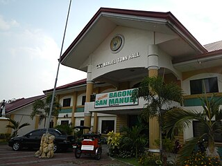
San Manuel, officially the Municipality of San Manuel, is a municipality in the province of Tarlac, Philippines. According to the 2020 census, it has a population of 28,387 people.

<span class="mw-page-title-main">Tarlac City</span> Capital of Tarlac, Philippines

Tarlac City, officially the City of Tarlac, is a 1st class component city and capital of the province of Tarlac, Philippines. According to the 2020 census, it has a population of 385,398 people.

<span class="mw-page-title-main">Muñoz, Nueva Ecija</span> Component city in Nueva Ecija, Philippines

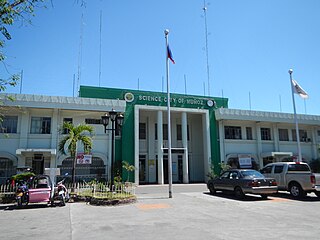
Muñoz, officially the Science City of Muñoz, is a 4th class component city in the province of Nueva Ecija, Philippines. According to the 2020 census, it has a population of 84,308 people.

<span class="mw-page-title-main">Aliaga, Nueva Ecija</span> Municipality in Nueva Ecija, Philippines

Aliaga, officially the Municipality of Aliaga, is a 2nd class municipality in the province of Nueva Ecija, Philippines. According to the 2020 census, it has a population of 70,363 people.

<span class="mw-page-title-main">Bongabon</span> Municipality in Nueva Ecija, Philippines

Bongabon, officially the Municipality of Bongabon, is a 2nd class municipality in the province of Nueva Ecija, Philippines. According to the 2020 census, it has a population of 66,839 people.

<span class="mw-page-title-main">Licab</span> Municipality in Nueva Ecija, Philippines

Licab, officially the Municipality of Licab, is a 4th-class municipality in the province of Nueva Ecija, Philippines. According to the 2020 census, it has a population of 29,269 people.

<span class="mw-page-title-main">Laur, Nueva Ecija</span> Municipality in Nueva Ecija, Philippines

Laur, officially the Municipality of Laur, is a 3rd class municipality in the province of Nueva Ecija in Central Luzon region of Philippines. According to the 2020 census, it has a population of 38,263 people. Laur is located at the foothills of the Sierra Madre Mountains.

<span class="mw-page-title-main">Nampicuan</span> Municipality in Nueva Ecija, Philippines

Nampicuan, officially the Municipality of Nampicuan, is a 5th class municipality in the province of Nueva Ecija, Philippines. According to the 2020 census, it has a population of 14,471 people.

<span class="mw-page-title-main">Quezon, Nueva Ecija</span> Municipality in Nueva Ecija, Philippines

Quezon, officially the Municipality of Quezon, is a 4th class municipality in the province of Nueva Ecija, Philippines that was named from the 2nd president of the Philippines, Manuel L. Quezon. According to the 2020 census, it has a population of 41,845 people.

References

  1. Municipality of Tayug | (DILG)
  2. "2015 Census of Population, Report No. 3 – Population, Land Area, and Population Density" (PDF). Philippine Statistics Authority. Quezon City, Philippines. August 2016. ISSN   0117-1453. Archived (PDF) from the original on May 25, 2021. Retrieved July 16, 2021.
  3. Error: Unable to display the reference properly. See the documentation for details.
  4. 1 2 Census of Population (2020). "Region I (Ilocos Region)". Total Population by Province, City, Municipality and Barangay. Philippine Statistics Authority . Retrieved 8 July 2021.
  5. "PSA Releases the 2018 Municipal and City Level Poverty Estimates". Philippine Statistics Authority. 15 December 2021. Retrieved 22 January 2022.
  6. Bergaño, Fray Diego (2007). Vocabulario de Pampango en Romance, Y Diccionario de Romance en Pampango [Vocabulary of the Kapampangan Language in Spanish and Dictionary of the Spanish Language in Kapampangan](PDF). Translated by Samson, Fr. Venancio. Angeles City, Pampanga, Philippines: Holy Angel University Press. p. 196. ISBN   978-971-93672-1-5.
  7. "CONTENTdm". ustdigitallibrary.contentdm.oclc.org. Retrieved 2024-03-15.
  8. "CONTENTdm". ustdigitallibrary.contentdm.oclc.org. Retrieved 2024-03-15.
  9. "Tayug, Pangasinan: Average Temperatures and Rainfall". World Weather Online. Retrieved 31 October 2015.
  10. Census of Population (2015). "Region I (Ilocos Region)". Total Population by Province, City, Municipality and Barangay. Philippine Statistics Authority . Retrieved 20 June 2016.
  11. Census of Population and Housing (2010). "Region I (Ilocos Region)" (PDF). Total Population by Province, City, Municipality and Barangay. National Statistics Office . Retrieved 29 June 2016.
  12. Censuses of Population (1903–2007). "Region I (Ilocos Region)". Table 1. Population Enumerated in Various Censuses by Province/Highly Urbanized City: 1903 to 2007. National Statistics Office.{{cite encyclopedia}}: CS1 maint: numeric names: authors list (link)
  13. "Province of Pangasinan". Municipality Population Data. Local Water Utilities Administration Research Division. Retrieved 17 December 2016.
  14. "Poverty incidence (PI):". Philippine Statistics Authority. Retrieved December 28, 2020.
  15. "Estimation of Local Poverty in the Philippines" (PDF). Philippine Statistics Authority. 29 November 2005.
  16. "2003 City and Municipal Level Poverty Estimates" (PDF). Philippine Statistics Authority. 23 March 2009.
  17. "City and Municipal Level Poverty Estimates; 2006 and 2009" (PDF). Philippine Statistics Authority. 3 August 2012.
  18. "2012 Municipal and City Level Poverty Estimates" (PDF). Philippine Statistics Authority. 31 May 2016.
  19. "Municipal and City Level Small Area Poverty Estimates; 2009, 2012 and 2015". Philippine Statistics Authority. 10 July 2019.
  20. "PSA Releases the 2018 Municipal and City Level Poverty Estimates". Philippine Statistics Authority. 15 December 2021. Retrieved 22 January 2022.
  21. "2022 National and Local Elections". Commission on Elections. Retrieved March 7, 2022.
  22. "Rest in Peace, Councilor Clarissa Calimlim". Facebook. Councilor Michael Dy. Retrieved 2024-03-18.