Agno, Pangasinan

Last updated
Agno
Municipality of Agno
AgnoPangasinanHalljf9298 01.JPG
Presidencia Agno Pangasinan
Agno Pangasinan.png
Ph locator pangasinan agno.png
Map of Pangasinan with Agno highlighted
OpenStreetMap
Agno, Pangasinan
Philippines location map (square).svg
Red pog.svg
Agno
Location within the Philippines
Coordinates: 16°06′58″N119°48′10″E / 16.116086°N 119.802683°E / 16.116086; 119.802683
Country Philippines
Region Ilocos Region
Province Pangasinan
District 1st district
Founded November 25, 1791 [1]
Barangays 17 (see Barangays)
Government
[2]
  Type Sangguniang Bayan
   Mayor Gualberto R. Sison
   Vice Mayor Jonathan G. Doromal
   Representative Arthur F. Celeste
   Municipal Council
Members
   Electorate 20,368 voters (2022)
Area
[3]
  Total169.75 km2 (65.54 sq mi)
Elevation
43 m (141 ft)
Highest elevation
140 m (460 ft)
Lowest elevation
0 m (0 ft)
Population
 (2020 census) [4]
  Total29,947
  Density180/km2 (460/sq mi)
   Households
7,382
Economy
   Income class 3rd municipal income class
   Poverty incidence
11.68
% (2018) [5]
   Revenue 137.9 million (2020)
   Assets 329.1 million (2020)
   Expenditure 136.4 million (2020)
   Liabilities 56.46 million (2020)
Service provider
  ElectricityPangasinan 1 Electric Cooperative (PANELCO 1)
Time zone UTC+8 (PST)
ZIP code
2408
PSGC
IDD : area code +63(0)75
Native languages Pangasinan
Ilocano
Tagalog
Website www.agno.gov.ph

Agno, officially the Municipality of Agno (Pangasinan : Baley na Agno; Ilocano : Ili ti Agno; Tagalog : Bayan ng Agno), is a 3rd class municipality in the province of Pangasinan, Philippines. According to the 2020 census, it has a population of 29,947 people. [4]

Contents

Etymology

The name Agno was derived from a species of swamp tree called “Agno Casto”, a chaste tree used for medicinal concoctions to relieve pain and illness, that grew abundantly in the locality. In time, “Agno” was retained to become the name of the town.

History

Agno was formally organized into Municipality in 1791. During the Spanish regime and early part of the American era, Agno was part of the Province of Zambales, but upon enactment of Public Act No. 1004 dated November 30, 1903, of the Philippine Commission, the northern part of Zambales including Agno was annexed to the Province of Pangasinan.

Geography

The town is characterized by rolling terrain and rainfed rice fields. Near the poblacion, or town plaza, the road passes along the Mabini river or (Balincaguing River), which drains into the South China Sea further west. The town plaza is home to a centuries-old Roman Catholic church, as well as one of the first congregations of the Philippine Independent Church. The town shares borders with the town of Bani to the north, the town of Mabini and Alaminos to the east and with Burgos to the south. Contrary to popular belief, the Agno River do not pass this municipality.

Barangays

Agno is politically subdivided into 17 barangays. [6] Each barangay consists of puroks and some have sitios.

  • Allabon
  • Aloleng
  • Bangan Oda
  • Baruan
  • Boboy
  • Cayungnan
  • Dangley
  • Gayusan
  • Macaboboni
  • Magsaysay
  • Namatucan
  • Patar
  • Poblacion East
  • Poblacion West
  • San Juan
  • Tupa
  • Viga

Climate

Climate data for Agno, Pangasinan
MonthJanFebMarAprMayJunJulAugSepOctNovDecYear
Average high °C (°F)31
(88)
31
(88)
32
(90)
34
(93)
35
(95)
34
(93)
32
(90)
32
(90)
32
(90)
32
(90)
32
(90)
31
(88)
32
(90)
Average low °C (°F)22
(72)
22
(72)
22
(72)
24
(75)
24
(75)
24
(75)
24
(75)
24
(75)
24
(75)
23
(73)
23
(73)
22
(72)
23
(74)
Average precipitation mm (inches)13.6
(0.54)
10.4
(0.41)
18.2
(0.72)
15.7
(0.62)
178.4
(7.02)
227.9
(8.97)
368.0
(14.49)
306.6
(12.07)
310.6
(12.23)
215.7
(8.49)
70.3
(2.77)
31.1
(1.22)
1,766.5
(69.55)
Average rainy days3224141623212415106140
Source: World Weather Online [7]

Demographics

Population Census of Agno
YearPop.±% p.a.
1903 6,169    
1918 7,536+1.34%
1939 9,533+1.13%
1948 12,485+3.04%
1960 13,424+0.61%
1970 15,216+1.26%
1975 16,011+1.03%
1980 17,241+1.49%
1990 21,197+2.09%
1995 23,326+1.81%
2000 25,077+1.56%
2007 26,023+0.51%
2010 27,508+2.04%
2015 28,052+0.37%
2020 29,947+1.29%
Source: Philippine Statistics Authority [8] [9] [10] [11]

Economy

The town's main livelihood is fishing and agriculture, although a number of her sons and daughters work as doctors, physical therapist, nurses, engineers, computer programmers and accountants in numerous countries around the globe. On top of that, the town produces successful teachers, policemen and policewomen, and lawyers.

During the summer months of April and May the town's market abounds with fresh fruits such as mangoes and duhat, as well as fresh catch such as tuna, flying fish, grouper, lobsters and other seafood.

Tourism

The town is home to natural attractions such as the Mabini river, the Umbrella Rocks in Sabangan, as well as several beaches, Agno Beach being the longest and most popular. There are several other beaches hidden along the coast such as the Macaboboni cove (which features a small cave) as well as a white beach in Barangay Gayusan. To the southern end of Agno Beach, one can dive from a two-story-high rock amidst crashing waves and end up in a beautiful coral garden below. Agno is 71 kilometres (44 mi) from Lingayen and 277 kilometres (172 mi) from Manila.

Culture

Government

Local government

Agno, belonging to the first congressional district of the province of Pangasinan, is governed by a mayor designated as its local chief executive and by a municipal council as its legislative body in accordance with the Local Government Code. The mayor, vice mayor, and the councilors are elected directly by the people through an election which is being held every three years.

Elected officials

Members of the Municipal Council
(2022–2025) [19]
PositionName
CongressmanArthur F. Celeste
MayorGualberto R. Sison
Vice-MayorJonathan G. Doromal
CouncilorsRichard N. Raquel
Kristine N. Feble
Lorna N. Nivera
Archimedes L. Bundal Jr.
Edilberto C. Manalastas
Obed N. Sison
Elmo N. Nilo
Charlie Dave C. Rosete

Related Research Articles

<span class="mw-page-title-main">Binmaley</span> Municipality in Pangasinan, Philippines

Binmaley, officially the Municipality of Binmaley, is a 1st class municipality in the province of Pangasinan, Philippines. According to the 2020 census, it has a population of 86,881 people.

<span class="mw-page-title-main">Villasis</span> Municipality in Pangasinan, Philippines

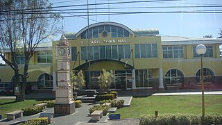
Villasis, officially the Municipality of Villasis, is a 1st class municipality in the province of Pangasinan, Philippines. According to the 2020 census, it has a population of 65,047 people.

<span class="mw-page-title-main">Alaminos, Pangasinan</span> Component city in Pangasinan, Philippines

Alaminos, officially the City of Alaminos, is a 4th class component city in the province of Pangasinan, Philippines, and is known for being the home of the Hundred Islands National Park, which is composed of 124 islands and is located off the coast of Barangay Lucap. According to the 2020 census, it has a population of 99,397 people. The city is named after Juan Alaminos y de Vivar, a former governor-general of the Philippines.

<span class="mw-page-title-main">Bani, Pangasinan</span> Municipality in Pangasinan, Philippines

Bani, officially the Municipality of Bani, is a 2nd class municipality in the province of Pangasinan, Philippines. According to the 2020 census, it has a population of 52,603 people.

<span class="mw-page-title-main">Basista</span> Municipality in Pangasinan, Philippines

Basista, officially the Municipality of Basista, is a 4th class municipality in the province of Pangasinan, Philippines. According to the 2020 census, it has a population of 37,679 people.

<span class="mw-page-title-main">Burgos, Pangasinan</span> Municipality in Pangasinan, Philippines

Burgos, officially the Municipality of Burgos, is a 4th class municipality in the province of Pangasinan, Philippines. According to the 2020 census, it has a population of 23,749 people.

<span class="mw-page-title-main">Dasol</span> Municipality in Pangasinan, Philippines

Dasol, officially the Municipality of Dasol, is a 3rd class municipality in the province of Pangasinan, Philippines. According to the 2020 census, it has a population of 31,355 people.

<span class="mw-page-title-main">Labrador, Pangasinan</span> Municipality in Pangasinan, Philippines

Labrador, officially the Municipality of Labrador, is a 4th class municipality in the province of Pangasinan, Philippines. According to the 2020 census, it has a population of 26,811 people.

<span class="mw-page-title-main">Mabini, Pangasinan</span> Municipality in Pangasinan, Philippines

Mabini, officially the Municipality of Mabini, is a 3rd class municipality in the province of Pangasinan, Philippines. According to the 2020 census, it has a population of 26,454 people.

<span class="mw-page-title-main">Mangatarem</span> Municipality in Pangasinan, Philippines

Mangatarem, officially the Municipality of Mangatarem, is a 1st class municipality in the province of Pangasinan, Philippines. According to the 2020 census, it has a population of 79,323 people.

<span class="mw-page-title-main">Mapandan</span> Municipality in Pangasinan, Philippines

Mapandan, officially the Municipality of Mapandan, is a 3rd class municipality in the province of Pangasinan, Philippines. According to the 2020 census, it has a population of 38,058 people.

<span class="mw-page-title-main">San Quintin, Pangasinan</span> Municipality in Pangasinan, Philippines

San Quintin, officially the Municipality of San Quintin, is a 3rd class municipality in the province of Pangasinan, Philippines. According to the 2020 census, it has a population of 33,980 people.

<span class="mw-page-title-main">Santa Maria, Pangasinan</span> Municipality in Pangasinan, Philippines

Santa Maria, officially the Municipality of Santa Maria, is a 4th class municipality in the province of Pangasinan, Philippines. According to the 2020 census, it has a population of 34,220 people.

<span class="mw-page-title-main">Santo Tomas, Pangasinan</span> Municipality in Pangasinan, Philippines

Santo Tomas, officially the Municipality of Santo Tomas, is a 5th class municipality in the province of Pangasinan, Philippines. According to the 2020 census, it has a population of 14,878 people.

<span class="mw-page-title-main">Tayug</span> Municipality in Pangasinan, Philippines

Tayug, officially the Municipality of Tayug, is a 3rd class municipality in the province of Pangasinan, Philippines. According to the 2020 census, it has a population of 45,241 people.

<span class="mw-page-title-main">Umingan</span> Municipality in Pangasinan, Philippines

Umingan, officially the Municipality of Umingan, is a 1st class municipality in the province of Pangasinan, Philippines. According to the 2020 census, it has a population of 77,074 people.

<span class="mw-page-title-main">Urbiztondo</span> Municipality in Pangasinan, Philippines

Urbiztondo, officially the Municipality of Urbiztondo, is a 3rd class municipality in the province of Pangasinan, Philippines. According to the 2020 census, it has a population of 55,557 people.

<span class="mw-page-title-main">San Carlos, Pangasinan</span> Component city in Pangasinan, Philippines

San Carlos, officially the City of San Carlos, is a 3rd class component city in the province of Pangasinan, Philippines. According to the 2020 census, it has a population of 205,424 people. It is the most populated city in Pangasinan and the entire Ilocos Region.

<span class="mw-page-title-main">San Manuel, Tarlac</span> Municipality in Tarlac, Philippines

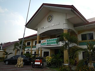
San Manuel, officially the Municipality of San Manuel, is a municipality in the province of Tarlac, Philippines. According to the 2020 census, it has a population of 28,387 people.

<span class="mw-page-title-main">Nampicuan</span> Municipality in Nueva Ecija, Philippines

Nampicuan, officially the Municipality of Nampicuan, is a 5th class municipality in the province of Nueva Ecija, Philippines. According to the 2020 census, it has a population of 14,471 people.

References

  1. "Nana Nena ng Kawit". 21 July 2014.
  2. Municipality of Agno | (DILG)
  3. "2015 Census of Population, Report No. 3 – Population, Land Area, and Population Density" (PDF). Philippine Statistics Authority. Quezon City, Philippines. August 2016. ISSN   0117-1453. Archived (PDF) from the original on May 25, 2021. Retrieved July 16, 2021.
  4. 1 2 Census of Population (2020). "Region I (Ilocos Region)". Total Population by Province, City, Municipality and Barangay. Philippine Statistics Authority . Retrieved 8 July 2021.
  5. "PSA Releases the 2018 Municipal and City Level Poverty Estimates". Philippine Statistics Authority. 15 December 2021. Retrieved 22 January 2022.
  6. "Province: PANGASINAN". PSGC Interactive. Makati, Philippines: National Statistical Coordination Board. Archived from the original on 14 November 2012. Retrieved 26 November 2012.
  7. "Agno, Pangasinan: Average Temperatures and Rainfall". World Weather Online. Retrieved 23 September 2015.
  8. Census of Population (2015). "Region I (Ilocos Region)". Total Population by Province, City, Municipality and Barangay. Philippine Statistics Authority . Retrieved 20 June 2016.
  9. Census of Population and Housing (2010). "Region I (Ilocos Region)". Total Population by Province, City, Municipality and Barangay. National Statistics Office . Retrieved 29 June 2016.
  10. Censuses of Population (1903–2007). "Region I (Ilocos Region)". Table 1. Population Enumerated in Various Censuses by Province/Highly Urbanized City: 1903 to 2007. National Statistics Office.
  11. "Province of Pangasinan". Municipality Population Data. Local Water Utilities Administration Research Division. Retrieved 17 December 2016.
  12. "Poverty incidence (PI):". Philippine Statistics Authority. Retrieved December 28, 2020.
  13. Error: Unable to display the reference properly. See the documentation for details.
  14. Error: Unable to display the reference properly. See the documentation for details.
  15. Error: Unable to display the reference properly. See the documentation for details.
  16. Error: Unable to display the reference properly. See the documentation for details.
  17. Error: Unable to display the reference properly. See the documentation for details.
  18. "PSA Releases the 2018 Municipal and City Level Poverty Estimates". Philippine Statistics Authority. 15 December 2021. Retrieved 22 January 2022.
  19. "2019 National and Local Elections" (PDF). Commission on Elections. Retrieved March 6, 2022.{{cite web}}: CS1 maint: url-status (link)