
Hiroo Onoda was a Japanese intelligence officer of the Imperial Japanese Army who fought in World War II and did not surrender at the war's end in August 1945. After the war ended, Onoda spent 29 years hiding in the Philippines until Norio Suzuki, a Japanese explorer and adventurer, found him and relayed the message that the Emperor wanted him to come back to Japan. He held the rank of second lieutenant in the Imperial Japanese Army (IJA).

Mindoro is the seventh largest and eighth-most populous island in the Philippines. With a total land area of 10,571 km2 and has a population of 1,408,454 as of 2020 census. It is located off the southwestern coast of Luzon and northeast of Palawan. Mindoro is divided into two provinces: Occidental Mindoro and Oriental Mindoro. San Jose is the largest settlement on the island with a total population of 143,430 inhabitants as of 2015. The southern coast of Mindoro forms the northeastern extremum of the Sulu Sea. Mount Halcon is the highest point on the island, standing at 8,484 feet (2,586 m) above sea level located in Oriental Mindoro. Mount Baco is the island's second highest mountain with an elevation of 8,163 feet (2,488 m), located in the province of Occidental Mindoro.

Oriental Mindoro, officially the Province of Oriental Mindoro, is a province in the Philippines located on the island of Mindoro under Mimaropa region in Luzon, about 140 kilometres (87 mi) southwest of Manila. The province is bordered by the Verde Island Passage and the rest of Batangas to the north, by Marinduque, Maestre de Campo Island, Tablas Strait and the rest of Romblon to the east, by Semirara and the rest of Caluya Islands, Antique to the south, and by Occidental Mindoro to the west. Calapan, the only city in the island, is the provincial capital and Mimaropa's regional center.

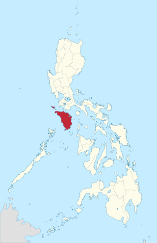
Occidental Mindoro, officially the Province of Occidental Mindoro, is a province in the Philippines located in the Mimaropa region. The province occupies the western half of the island of Mindoro. Its capital is Mamburao, but the largest municipality is San Jose occupying almost half of the entire province. As of 2020, Occidental Mindoro has 525,354 inhabitants.

San Jose, officially the Municipality of San Jose, is a 1st class municipality in the province of Occidental Mindoro, Philippines. According to the 2020 census, it has a population of 153,267, representing a third of the provincial population, and is the largest among cities and municipalities in the Mimaropa region.

Balete, officially the Municipality of Balete, is a 4th class municipality in the province of Aklan, Philippines. According to the 2020 census, it has a population of 30,090 people.

Cardona, officially the Municipality of Cardona, is a 3rd class municipality in the province of Rizal, Philippines. According to the 2020 census, it has a population of 50,143 people.

Balete, officially the Municipality of Balete, is a 5th class municipality in the province of Batangas, Philippines. According to the 2020 census, it has a population of 24,055 people. The people from Balete is called Baleteños.

Looc, officially the Municipality of Looc, is a 5th class municipality in the province of Occidental Mindoro, Philippines. According to the 2020 census, it has a population of 7,802 people, making it the least populated municipality in the province.

Lubang, officially the Municipality of Lubang, is a 4th class municipality in the province of Occidental Mindoro, Philippines. According to the 2020 census, it has a population of 17,437 people.
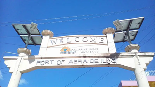
Abra de Ilog, officially the Municipality of Abra de Ilog, is a 2nd class municipality in the province of Occidental Mindoro, Philippines. According to the 2020 census, it has a population of 35,176 people.

Sablayan, officially the Municipality of Sablayan, is a 1st class municipality in the province of Occidental Mindoro, Philippines. According to the 2020 census, it has a population of 92,598 people.
Mindoro was a province of the Philippines from 1902 until 1950 when it was split into two provinces, Occidental Mindoro and Oriental Mindoro. It is located on Mindoro island, Philippines.

Apomys, commonly known as earthworm mice, is a genus of rodent endemic to the Philippines. Mice belonging to this genus are generally called Philippine forest mice and can be found on most islands of the Philippines except in Palawan, the Sulu Archipelago, and the Batanes and Babuyan group of islands.

The Cabra Island Lighthouse is a historic lighthouse built on Cabra Island, the north-westernmost of the Lubang group of islands in Occidental Mindoro, Philippines. International vessels entering the Philippines from South China Sea were welcomed by the Cabra Light and directed either towards Manila Bay or the center of the archipelago through Verde Island Passage, one of busiest sea routes of the Philippines.
Cabra is a barangay in the Philippines that covers the island of the same name. The island is the north-westernmost of the Lubang Group of Islands in the Verde Island Passage southwest of the country's main island of Luzon and northwest of the island of Mindoro. The barangay is administered as part of the municipality of Lubang, Occidental Mindoro.
Ambil is an island barangay in the Philippines that covers the island of the same name along with the two other smaller outlying islands of Mandaui and Malavatuan to the northeast. The barangay is administered as part of the municipality of Looc, Occidental Mindoro. The island, which is the 93rd largest island in the Philippines, was formed by a conical mountain that is around 2,461 feet (750 m) in height, Mount Benagongon.
Malavatuan or Malabatuan is a small island in the Philippines and part of the Lubang group of islands. It is around 3 miles (4.8 km) northeast of Ambil Island and is administered under the barangay of Ambil, in the municipality of Looc, Occidental Mindoro. In 1919 it was denoted as being covered in brushwood.
Mandaui is a small island in the Philippines and part of the Lubang group of islands. It is around .75 miles (1.21 km) northeast of Ambil Island and is administered under the barangay of Ambil, in the municipality of Looc, Occidental Mindoro. The island has two "small hills of uneven height."


