The Visayas, or the Visayan Islands, are one of the three principal geographical divisions of the Philippines, along with Luzon and Mindanao. Located in the central part of the archipelago, it consists of several islands, primarily surrounding the Visayan Sea, although the Visayas are also considered the northeast extremity of the entire Sulu Sea. Its inhabitants are predominantly the Visayan peoples.

Leyte is an island in the Visayas group of islands in the Philippines. It is eighth-largest and sixth-most populous island in the Philippines, with a total population of 2,626,970 as of 2020 census.

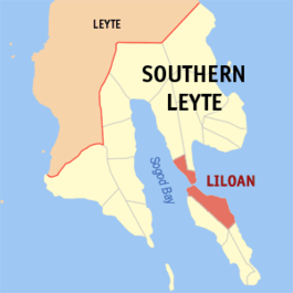
Southern Leyte, officially the Province of Southern Leyte, is a province in the Philippines located in the Eastern Visayas region. Its capital is the city of Maasin. Southern Leyte comprised the third congressional district Leyte until it was made into an independent province in 1959. Southern Leyte includes Limasawa, an island to the south where the first Roman Catholic Mass in Philippine soil is believed to have taken place and thus considered to be the birthplace of Roman Catholicism in the Philippines.

Surigao Strait is a strait in the southern Philippines, between the Bohol Sea and the Leyte Gulf of the Philippine Sea.

Ormoc, officially the City of Ormoc, is a 1st class independent component city in the Eastern Visayas region of the Philippines. According to the 2020 census, it has a population of 230,998 inhabitants, making it the second most-populous city in the province of Leyte after the provincial capital of Tacloban. Ormoc is the economic, cultural, commercial and transportation hub of western Leyte.

Samar is the third-largest and seventh-most populous island in the Philippines, with a total population of 1,909,537 as of the 2020 census. It is located in the eastern Visayas, which are in the central Philippines. The island is divided into three provinces: Samar, Northern Samar, and Eastern Samar. These three provinces, along with the provinces on the nearby islands of Leyte and Biliran, are part of the Eastern Visayas region.

Liloan, officially the Municipality of Liloan, is a 4th class municipality in the province of Southern Leyte, Philippines. According to the 2020 census, it has a population of 24,800 people.

Sogod, officially the Municipality of Sogod, is a 2nd class municipality in the province of Southern Leyte, Philippines. According to the 2020 census, it has a population of 47,552 people.

The Camotes Sea is a small sea within the Philippine archipelago, situated between the Central Visayan and the Eastern Visayan regions. It separates Cebu from Leyte hence is bordered by Cebu to the west, Leyte to the east and north, and Bohol to the south. At its center are the Camotes Islands, but it also contains Mactan Island, Olango Island, Lapinig Island, and various other small islets.

USS Bryant (The-420) was a Fletcher-class destroyer of the United States Navy, named for Rear Admiral Samuel W. Bryant (1877–1938).

The Pan-Philippine Highway, also known as the Maharlika Highway, is a network of roads, expressways, bridges, and ferry services that connect the islands of Luzon, Samar, Leyte, and Mindanao in the Philippines, serving as the country's principal transport backbone. Measuring 3,379.73 kilometers (2,100.07 mi) long excluding sea routes, it is the longest highway in the Philippines that forms the country's north–south backbone component of National Route 1 (N1) of the Philippine highway network. The entire highway is designated as Asian Highway 26 (AH26) of the Asian Highway Network.

The yellow-wattled bulbul is a species of songbird in the bulbul family of passerine birds. It is endemic to the Philippines.

Pachliopta kotzebuea, the pink rose, is a butterfly of the family Papilionidae. It is found in the Philippines.

Atrophaneura semperi is a species of butterfly from the family Papilionidae that is found in Indonesia, Malaysia, and the Philippines. It is the type species for the genus.

Pachliopta mariae is a species of butterfly from the family Papilionidae that is found in the Philippines.

The Flag of Southern Leyte is the provincial flag of Southern Leyte, Philippines. It is a green field with thin white horizontal and vertical stripes meeting within the upper hoist quarter of the flag to form an offset cross; upon this cross is a wreath composed of an abaca leaf and a palm frond, while four "Star of Leyte" orchid flowers are set in a descending diagonal line from the cross intersection to the lower fly.
Eastern Visayas is an administrative region in the Philippines, designated as Region VIII. It consists of three main islands, Samar, Leyte and Biliran. The region has six provinces, one independent city and one highly urbanized city namely, Biliran, Leyte, Northern Samar, Samar, Eastern Samar, Southern Leyte, Ormoc and Tacloban. The highly urbanized city of Tacloban is the sole regional center. These provinces and cities occupy the easternmost islands of the Visayas group of islands.
National Route 1 (N1) is a primary national route that forms part of the Philippine highway network, running from Luzon to Mindanao. Except for a 19-kilometer (12 mi) gap in Metro Manila and ferry connections, the highway is generally continuous. Most sections of N1 forms the Pan-Philippine Highway except for sections bypassed by expressways.

US Naval Base Philippines was number of United States Navy bases in the Philippines Islands in the Pacific Ocean. Most were built by the US Navy Seabees, Naval Construction Battalions, during World War II. The US Naval Bases in Philippines were lost to the Empire of Japan in December 1941 during the Philippines campaign of 1941–1942. In February 1945 the United States Armed Forces retook the Philippines in the Battle of Manila in 1945. Before the captured US bases on Luzon were retaken the US Navy Seabees built a new large base, Leyte-Samar Naval Base, on the Philippine Island of Leyte, starting in October 1944.