Catarman, Northern Samar

Last updated

Catarman
Municipality of Catarman
Catarman Aerial-cr.jpg
Aerial view of Catarman
Flag of Catarman, Northern Samar.png
Catarman Northern Samar.png
Ph locator northern samar catarman.png
Map of Northern Samar with Catarman highlighted
OpenStreetMap
Catarman, Northern Samar
Philippines location map (square).svg
Red pog.svg
Catarman
Location within the Philippines
Coordinates: 12°29′58″N124°37′58″E / 12.4994°N 124.6328°E / 12.4994; 124.6328
Country Philippines
Region Eastern Visayas
Province Northern Samar
District 1st district
Barangays 55 (see Barangays)
Government
[1]
  Type Sangguniang Bayan
   Mayor Francisco Aurelio E. Rosales III
   Vice Mayor Francisco C. Rosales Jr.
   Representative Paul R. Daza
  Councilors
List
   Electorate 61,074 voters (2022)
Area
[2]
  Total464.43 km2 (179.32 sq mi)
Elevation
15 m (49 ft)
Highest elevation
142 m (466 ft)
Lowest elevation
−1 m (−3 ft)
Population
 (2020 census) [3]
  Total97,879
  Density210/km2 (550/sq mi)
   Households
20,836
Demonym Catarmanon
Economy
   Income class 1st municipal income class
   Poverty incidence
30.27
% (2018) [4]
   Revenue 458.3 million (2020)
   Assets 962 million (2020)
   Expenditure 422.2 million (2020)
Service provider
   Electricity Northern Samar Electric Cooperative (NORSAMELCO)
Time zone UTC+8 (PST)
Zip Code
6400
PSGC
IDD : area code +63(0)55
Native languages Waray
Tagalog
Website www.catarman-nsamar.gov.ph

Catarman, officially the Municipality of Catarman (Waray [Ninorte Samarnon]: Bungto san Catarman; Tagalog : Bayan ng Catarman), is a 1st class municipality and capital of the province of Northern Samar, Philippines. According to the 2020 census, it has a population of 97,879 people. [3] It is the commercial, educational, financial, and political center of the province and also its most populous municipality.

Contents

History

Catarman Municipal Hall Catarman, Northern Samar Municipal Hall 02.JPG
Catarman Municipal Hall
Catarman Legislative Building Catarman Legislative Building.JPG
Catarman Legislative Building

Before the coming of the Spaniards, Catarman (also known as Calatman or Cataruman) was a settlement by the mouth of the river of the same name in the region called Ibabao. The Spanish Conquistadors applied the term Ibabao to the northern part of Samar island when it established its civil government. The similarities in the vocabularies and pronunciation of the dialects of these areas traces them to a common root as a people.

The town was one of the 13 villages and settlements and adopted as pueblos by the Spaniards in Samar Island and was one of the settlements in the northern parts of the island. The pueblo was named Calatman and was one of the pueblos in the Visayan islands, then collectively referred to as Islas de Pintados [Island of the Painted Ones].

In 1974, Catarman was made the center of the episcopal see of the then newly established Roman Catholic Diocese of Catarman comprising the Northern Samar province, with the Our Lady of the Annunciation Parish Church as the designated cathedral. [5]

Cityhood

In 2003, its application for cityhood was deterred after officials of the neighboring of towns Bobon, Lope de Vega, and Mondragon opposed the planned Catarman City conglomeration, which was necessary to meet the criteria for the approval of its bid for cityhood. Another bill was filed converting the Municipality of Catarman into a component city of Northern Samar but is still pending with the Committee on Local Government in the House of Representatives since July 2010. The rise of establishments and banking institutions has swiftly came and filled the spaces of Catarman that paved the way for it to become competitive.

In the 19th Congress of the Philippines, house bills were filed by various representatives which seeks Catarman including other capital towns of provinces with no current component cities, independent component cities or highly urbanized cities to automatically convert into cities. [6] [7] [8]

Geography

Welcome arch to Catarman Welcome Arch at Catarman, Northern Samar.JPG
Welcome arch to Catarman
Dalakit Beach Dalakit Beach, Pacific waves (Catarman, Northern Samar; 04-27-2023).jpg
Dalakit Beach

Catarman lies on the northern part of Samar Island, bounded to the east by Mondragon, to the west by Bobon, to the south by Lope de Vega, to the southwest by Calbayog City, and to the north by the Philippine Sea.

On the Pacific coast are flat lowlands with the interior characterized by outlying low hills. Mount Puyao in Barangay Liberty is the highest peak in the area. The Catarman River, a major provincial river, divides the eastern and the western parts of the town. It is fed by the Paticua, Hibulwangan, Mahangna, Tura, and Danao creeks together with less prominent estuaries.

Barangays

Catarman is politically subdivided into 55 barangays. Each barangay consists of puroks and some have sitios.

  • Acacia (pob.)
  • Aguinaldo
  • Airport Village (pob.)
  • Bangkerohan
  • Baybay (pob.)
  • Bocsol
  • Cabayhan
  • Cag-abaca
  • Cal-igang
  • Calachuchi (pob.)
  • Casoy (pob.)
  • Cawayan
  • Cervantes
  • Cularima
  • Daganas
  • Dalakit
  • Doña Pulqueria
  • Galutan
  • Gebalagnan
  • Gibulwangan
  • Guba
  • Hinatad
  • Imelda
  • Ipil-ipil (pob.)
  • Jose Abad Santos (pob.)
  • Jose P. Rizal (pob.)
  • Lapu-lapu (pob.)
  • Liberty
  • Libjo
  • Mabini
  • Mabolo (pob.)
  • Macagtas
  • Malvar
  • McKinley
  • Molave (pob.)
  • Narra (pob.)
  • New Rizal
  • Old Rizal
  • Paticua
  • Polangi
  • Quezon
  • Salvacion
  • Sampaguita (pob.)
  • San Julian
  • San Pascual
  • Santol (pob.)
  • Somoge
  • Talisay (pob.)
  • Tinowaran
  • Trangue
  • UEP Zone I
  • UEP Zone II
  • UEP Zone III
  • Washington
  • Yakal (pob.)

Climate

Climate data for Catarman, Northern Samar (1991–2020, extremes 1949–2020)
MonthJanFebMarAprMayJunJulAugSepOctNovDecYear
Record high °C (°F)34.2
(93.6)
34.0
(93.2)
35.4
(95.7)
37.2
(99.0)
37.7
(99.9)
38.0
(100.4)
36.7
(98.1)
37.1
(98.8)
37.5
(99.5)
35.5
(95.9)
36.0
(96.8)
34.3
(93.7)
38.0
(100.4)
Mean daily maximum °C (°F)29.3
(84.7)
29.9
(85.8)
30.7
(87.3)
32.0
(89.6)
33.1
(91.6)
32.9
(91.2)
32.3
(90.1)
32.8
(91.0)
32.6
(90.7)
31.6
(88.9)
30.8
(87.4)
29.9
(85.8)
31.5
(88.7)
Daily mean °C (°F)26.0
(78.8)
26.2
(79.2)
26.7
(80.1)
27.6
(81.7)
28.5
(83.3)
28.4
(83.1)
28.1
(82.6)
28.5
(83.3)
28.2
(82.8)
27.6
(81.7)
27.1
(80.8)
26.6
(79.9)
27.5
(81.5)
Mean daily minimum °C (°F)22.7
(72.9)
22.5
(72.5)
22.6
(72.7)
23.2
(73.8)
23.9
(75.0)
24.0
(75.2)
23.9
(75.0)
24.1
(75.4)
23.9
(75.0)
23.6
(74.5)
23.5
(74.3)
23.3
(73.9)
23.5
(74.3)
Record low °C (°F)16.9
(62.4)
17.2
(63.0)
17.6
(63.7)
19.0
(66.2)
20.0
(68.0)
20.0
(68.0)
20.8
(69.4)
20.6
(69.1)
19.4
(66.9)
19.9
(67.8)
17.8
(64.0)
18.2
(64.8)
16.9
(62.4)
Average rainfall mm (inches)520.1
(20.48)
310.5
(12.22)
312.4
(12.30)
152.5
(6.00)
162.9
(6.41)
217.3
(8.56)
221.9
(8.74)
167.7
(6.60)
205.8
(8.10)
331.9
(13.07)
457.8
(18.02)
689.9
(27.16)
3,750.7
(147.67)
Average rainy days (≥ 0.1 mm)211515111013141112172224185
Average relative humidity (%)89878684838485838486888986
Source: PAGASA [9] [10]

Demographics

Catarman Cathedral Catarman Cathedral in Samar province.jpg
Catarman Cathedral
Population census of Catarman
YearPop.±% p.a.
1903 9,994    
1918 13,278+1.91%
1939 21,007+2.21%
1948 33,153+5.20%
1960 39,434+1.46%
YearPop.±% p.a.
1970 44,438+1.20%
1975 53,267+3.70%
1980 59,021+2.07%
1990 50,965−1.46%
1995 61,705+3.65%
YearPop.±% p.a.
2000 67,671+2.00%
2007 81,067+2.52%
2010 84,833+1.67%
2015 94,037+1.98%
2020 97,879+0.79%
Source: Philippine Statistics Authority [11] [12] [13] [14]

Economy

A Jollibee branch in Catarman Jollibee at Catarman, Northern Samar.JPG
A Jollibee branch in Catarman

Poverty Incidence of Catarman

10
20
30
40
50
2006
29.80
2009
43.38
2012
34.83
2015
36.02
2018
30.27
2021
20.64

Source: Philippine Statistics Authority [15] [16] [17] [18] [19] [20] [21] [22]

Transportation

Catarman National Airport Terminal CRMTerminalBldg.jpg
Catarman National Airport Terminal
Pedicabs, one of the transportation modes in the town Pedicab at Catarman, Northern Samar.JPG
Pedicabs, one of the transportation modes in the town

PAL Express is the only airline operating through the Catarman National Airport, with flights between Manila and Catarman four times weekly. Flights are frequently booked well in advance due to ticket costs. Pedicabs and motorized tricycles are the means of transportation within the town. Jeepneys, vans, and buses are the means of transportation between Catarman and neighboring towns. Several vans and bus companies also operate to serve travelers between the town and Manila.

Education

Catarman is home to the University of Eastern Philippines, the first state university in the Visayas and the largest university by student population and curriculum in Eastern Visayas. The university has satellite campuses in the province, one in Laoang and the other in Catubig (officially known the Pedro Rebadulla Memorial Campus), and has several extension programs offered across satellite campuses in the region.

Other prominent public and private educational institutions:

Elementary:

High School:

College/Vocational:

University of Eastern Philippines University of Eastern Philippines NHCP Marker Site.jpg
University of Eastern Philippines

Notable personalities

Related Research Articles

<span class="mw-page-title-main">Northern Samar</span> Province in Eastern Visayas, Philippines

Northern Samar, officially the Province of Northern Samar, is a province in the Philippines located in the Eastern Visayas region. Its capital is Catarman and is located at the northern portion of the island of Samar. Bordering the province to the south are the provinces of Samar and Eastern Samar. To the northwest, across the San Bernardino Strait is Sorsogon; to the east is the Philippine Sea of the Pacific Ocean and to the west is Samar Sea.

<span class="mw-page-title-main">Basey</span> Municipality in Samar, Philippines

Basey, officially the Municipality of Basey, is a 1st class municipality in the province of Samar, Philippines. According to the 2020 census, it has a population of 56,685 people.

<span class="mw-page-title-main">Pinabacdao</span> Municipality in Samar, Philippines

Pinabacdao, officially the Municipality of Pinabacdao, is a 4th class municipality in the province of Samar, Philippines. According to the 2020 census, it has a population of 18,136 people.

<span class="mw-page-title-main">San Sebastian, Samar</span> Municipality in Samar, Philippines

San Sebastian, officially the Municipality of San Sebastian, is a 6th class municipality in the province of Samar, Philippines. According to the 2020 census, it has a population of 8,704 people.

<span class="mw-page-title-main">Santa Rita, Samar</span> Municipality in Samar, Philippines

Santa Rita, officially the Municipality of Santa Rita, is a 3rd class municipality in the province of Samar, Philippines. According to the 2020 census, it has a population of 42,384 people.

<span class="mw-page-title-main">Villareal, Samar</span> Municipality in Samar, Philippines

Villareal, officially the Municipality of Villareal, is a 4th class municipality in the province of Samar, Philippines. According to the 2020 census, it has a population of 27,394 people.

<span class="mw-page-title-main">Biri, Northern Samar</span> Municipality in Northern Samar, Philippines

Biri, officially the Municipality of Biri, is a 5th class municipality in the province of Northern Samar, Philippines. According to the 2020 census, it has a population of 11,274 people.

<span class="mw-page-title-main">Bobon</span> Municipality in Northern Samar, Philippines

Bobon, officially the Municipality of Bobon, is a 4th class municipality in the province of Northern Samar, Philippines. According to the 2020 census, it has a population of 25,965 people.

<span class="mw-page-title-main">Capul</span> Municipality in Northern Samar, Philippines

Capul, officially the Municipality of Capul, is a 5th class island municipality in the province of Northern Samar, Philippines. According to the 2020 census, it has a population of 12,323 people.

<span class="mw-page-title-main">Catubig</span> Municipality in Northern Samar, Philippines

Catubig, officially the Municipality of Catubig, is a 3rd class municipality in the province of Northern Samar, Philippines. According to the 2020 census, it has a population of 32,174 people.

<span class="mw-page-title-main">Laoang</span> Municipality in Northern Samar, Philippines

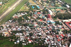
Laoang, officially the Municipality of Laoang, is a 2nd class municipality in the province of Northern Samar, Philippines. According to the 2020 census, it has a population of 61,607 people.

<span class="mw-page-title-main">Lope de Vega, Northern Samar</span> Municipality in Northern Samar, Philippines

Lope de Vega, officially the Municipality of Lope de Vega, is a 4th class municipality in the province of Northern Samar, Philippines. According to the 2020 census, it has a population of 14,690 people.

<span class="mw-page-title-main">San Jose, Northern Samar</span> Municipality in Northern Samar, Philippines

San Jose, officially the Municipality of San Jose, is a 5th class municipality in the province of Northern Samar, Philippines. According to the 2020 census, it has a population of 17,641 people.

<span class="mw-page-title-main">San Vicente, Northern Samar</span> Municipality in Northern Samar, Philippines

San Vicente, officially the Municipality of San Vicente, is a 6th class municipality in the province of Northern Samar, Philippines.

<span class="mw-page-title-main">Victoria, Northern Samar</span> Municipality in Northern Samar, Philippines

Victoria, officially the Municipality of Victoria, is a 5th class municipality in the province of Northern Samar, Philippines. According to the 2020 census, it has a population of 15,361 people.

<span class="mw-page-title-main">Dolores, Eastern Samar</span> Municipality in Eastern Samar, Philippines

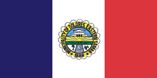
Dolores, officially the Municipality of Dolores, is a 3rd class municipality in the province of Eastern Samar, Philippines. According to the 2020 census, it has a population of 44,626 people.

<span class="mw-page-title-main">General MacArthur, Eastern Samar</span> Municipality in Eastern Samar, Philippines

General MacArthur, officially the Municipality of General MacArthur, is a 5th class municipality in the province of Eastern Samar, Philippines. According to the 2020 census, it has a population of 14,411 people.

<span class="mw-page-title-main">Taft, Eastern Samar</span> Municipality in Eastern Samar, Philippines

Taft, officially the Municipality of Taft, is a 4th class municipality in the province of Eastern Samar, Philippines. According to the 2020 census, it has a population of 18,786 people.

<span class="mw-page-title-main">Tabontabon</span> Municipality in Leyte, Philippines

Tabontabon, officially the Municipality of Tabontabon, is a 5th class municipality in the province of Leyte, Philippines. According to the 2020 census, it has a population of 11,902 people.

<span class="mw-page-title-main">Eastern Visayas</span> Administrative region of the Philippines

Eastern Visayas is an administrative region in the Philippines, designated as Region VIII. It consists of three main islands, Samar, Leyte and Biliran. The region has six provinces, one independent city and one highly urbanized city namely, Biliran, Leyte, Northern Samar, Samar, Eastern Samar, Southern Leyte, Ormoc and Tacloban. The highly urbanized city of Tacloban is the sole regional center. These provinces and cities occupy the easternmost islands of the Visayas group of islands.

References

  1. Municipality of Catarman | (DILG)
  2. "2015 Census of Population, Report No. 3 – Population, Land Area, and Population Density" (PDF). Philippine Statistics Authority. Quezon City, Philippines. August 2016. ISSN   0117-1453. Archived (PDF) from the original on May 25, 2021. Retrieved July 16, 2021.
  3. 1 2 Census of Population (2020). "Region VIII (Eastern Visayas)". Total Population by Province, City, Municipality and Barangay. Philippine Statistics Authority . Retrieved July 8, 2021.
  4. "PSA Releases the 2018 Municipal and City Level Poverty Estimates". Philippine Statistics Authority. December 15, 2021. Retrieved January 22, 2022.
  5. "Cathedral of Our Lady of the Annunciation Catarman, Northern Samar, Eastern Visayas, Philippines". GCatholic. Retrieved March 25, 2021.
  6. Yap, Eric (June 30, 2022). "An Act Automatically Converting the Capital Town of Provinces with No Component Cities, Independent Component Cities or Highly Urbanized Cities Within its Territorial Jurisdiction, into a Component City" (PDF). House of Representatives of the Philippines. Retrieved April 1, 2023.
  7. Palma, Wilter (August 9, 2022). "An Act Automatically Converting the Capital Town of Provinces with No Component Cities, Independent Component Cities, or Highly Urbanized Cities Within its Territorial Jurisdiction, into a Component City" (PDF). House of Representatives of the Philippines. Retrieved April 1, 2023.
  8. Daza, Paul (August 11, 2022). "An Act Convering into Component Cities the Capital Towns of Provinces Without a City, Amending for the Purpose Section 450 of Republic Act No. 7610, as Amended by Republic Act No. 9009, Otherwise Known as the Local Government Code of 1991, and for Other Purposes" (PDF). House of Representatives of the Philippines. Retrieved April 1, 2023.
  9. "Catarman, Northern Samar Climatological Normal Values 1991–2020" (PDF). Philippine Atmospheric, Geophysical and Astronomical Services Administration. Archived from the original (PDF) on March 1, 2022. Retrieved June 24, 2022.
  10. "Catarman, Northern Samar Climatological Extremes" (PDF). Philippine Atmospheric, Geophysical and Astronomical Services Administration. Archived from the original (PDF) on March 7, 2022. Retrieved June 24, 2022.
  11. Census of Population (2015). "Region VIII (Eastern Visayas)". Total Population by Province, City, Municipality and Barangay. Philippine Statistics Authority . Retrieved June 20, 2016.
  12. Census of Population and Housing (2010). "Region VIII (Eastern Visayas)" (PDF). Total Population by Province, City, Municipality and Barangay. National Statistics Office . Retrieved June 29, 2016.
  13. Censuses of Population (1903–2007). "Region VIII (Eastern Visayas)". Table 1. Population Enumerated in Various Censuses by Province/Highly Urbanized City: 1903 to 2007. National Statistics Office.{{cite encyclopedia}}: CS1 maint: numeric names: authors list (link)
  14. "Province of Northern Samar". Municipality Population Data. Local Water Utilities Administration Research Division. Retrieved December 17, 2016.
  15. "Poverty incidence (PI):". Philippine Statistics Authority. Retrieved December 28, 2020.
  16. "Estimation of Local Poverty in the Philippines" (PDF). Philippine Statistics Authority. November 29, 2005.
  17. "2003 City and Municipal Level Poverty Estimates" (PDF). Philippine Statistics Authority. March 23, 2009.
  18. "City and Municipal Level Poverty Estimates; 2006 and 2009" (PDF). Philippine Statistics Authority. August 3, 2012.
  19. "2012 Municipal and City Level Poverty Estimates" (PDF). Philippine Statistics Authority. May 31, 2016.
  20. "Municipal and City Level Small Area Poverty Estimates; 2009, 2012 and 2015". Philippine Statistics Authority. July 10, 2019.
  21. "PSA Releases the 2018 Municipal and City Level Poverty Estimates". Philippine Statistics Authority. December 15, 2021. Retrieved January 22, 2022.
  22. "PSA Releases the 2021 City and Municipal Level Poverty Estimates". Philippine Statistics Authority. April 2, 2024. Retrieved April 28, 2024.
  23. Grant, Frederick D. (1902). Annual Reports of the War Department for the Fiscal year June 30 1902 | Volume IX. U.S. Government Printing Office. p. 419.
  24. Sugbo, Victor, ed. (1995). Tinipigan: An Anthology of Waray Literature. Manila, Philippines: National Commission for Culture and the Arts. p. 272. OCLC   645852700 . Retrieved September 27, 2019.