San Vicente, Northern Samar

Last updated
San Vicente
Municipality of San Vicente
San Vicente NorSam.jpg
Aerial view of the islands
Flag of San Vicente, Northern Samar.png
Ph locator northern samar san vicente.png
Map of Northern Samar with San Vicente highlighted
OpenStreetMap
San Vicente, Northern Samar
Philippines location map (square).svg
Red pog.svg
San Vicente
Location within the Philippines
Coordinates: 12°21′N124°03′E / 12.35°N 124.05°E / 12.35; 124.05
Country Philippines
Region Eastern Visayas
Province Northern Samar
District 1st district
Founded June 18, 1966 [1]
Barangays 7 (see Barangays)
Government
[2]
  Type Sangguniang Bayan
   Mayor Edgar T. Catarongan, Jr.[ citation needed ]
   Vice Mayor Tito M. Luñeza[ citation needed ]
   Representative Paul R. Daza
  Councilors
List
   Electorate 6,108 voters (2022)
Area
[3]
  Total15.8 km2 (6.1 sq mi)
Elevation
3.0 m (9.8 ft)
Highest elevation
206 m (676 ft)
Lowest elevation
0 m (0 ft)
Population
 (2020 census) [4]
  Total6,928
  Density440/km2 (1,100/sq mi)
   Households
1,736
Economy
   Income class 6th municipal income class
   Poverty incidence
37.31
% (2018) [5]
   Revenue 56.1 million (2020)
   Assets 166.9 million (2020)
   Expenditure 33.5 million (2020)
   Liabilities 48.72 million (2020)
Service provider
  ElectricityNorthern Samar Electric Cooperative (NORSAMELCO)
Time zone UTC+8 (PST)
ZIP code
6419
PSGC
IDD : area code +63(0)55
Native languages Waray
Tagalog

San Vicente, officially the Municipality of San Vicente (Waray : Bungto han San Vicente; Cebuano : Lungsod sa San Vicente; Tagalog : Bayan ng San Vicente), is a 6th class municipality in the province of Northern Samar, Philippines.

Contents

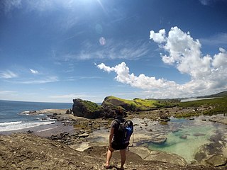
It is an island-municipality composed of seven islands of the Naranjo Island Group: Sila, Tarnate, Sangputan, Panganoron (Medio), Mahaba (Rasa), Maragat (San Andres) and Destacado [6] where the town proper is located. Destacado island is in the southernmost part of the group of islands comprising the municipality.

Locals speak Cebuano language and part Waray-Waray. According to the 2020 census, it has a population of 6,928 people. [4] It is the smallest municipality in the province, both in area and population.

The island municipality of San Vicente consists of six major islands; Destacado, Panganoron, Mahaba, Maragat, Sila, Tarnate, Sangputan. The islands of Panganoron, Mahaba, Maragat, Sila Tarnate and Sangputan form a circle of island group while Destacado lies in the far south of the group. The seat of government and town center is located in Destacado Island which is separated several nautical miles from the rest of the group. Other smaller islands also form part of the municipality of San Vicente.

Geography

Naranjo Islands satellite image captured by Sentinel-2 in 2016 Naranjo Islands, PH, Sentinel-2.jpg
Naranjo Islands satellite image captured by Sentinel-2 in 2016

Barangays

San Vicente is politically subdivided into 7 barangays. Each barangay consists of puroks and some have sitios.

Climate

Climate data for San Vicente, Northern Samar
MonthJanFebMarAprMayJunJulAugSepOctNovDecYear
Mean daily maximum °C (°F)29
(84)
29
(84)
31
(88)
32
(90)
32
(90)
32
(90)
31
(88)
31
(88)
30
(86)
29
(84)
29
(84)
29
(84)
30
(87)
Mean daily minimum °C (°F)23
(73)
22
(72)
23
(73)
23
(73)
23
(73)
25
(77)
25
(77)
25
(77)
24
(75)
24
(75)
24
(75)
23
(73)
24
(74)
Average precipitation mm (inches)39
(1.5)
34
(1.3)
42
(1.7)
36
(1.4)
73
(2.9)
109
(4.3)
118
(4.6)
108
(4.3)
129
(5.1)
165
(6.5)
112
(4.4)
89
(3.5)
1,054
(41.5)
Average rainy days12.69.7121320.525.326.224.825.225.921.917.9235
Source: Meteoblue [7]

Demographics

Population census of San Vicente
YearPop.±% p.a.
1970 4,122    
1975 4,184+0.30%
1980 4,786+2.72%
1990 5,777+1.90%
1995 5,970+0.62%
2000 5,831−0.50%
2007 6,506+1.52%
2010 7,447+5.04%
2015 7,856+1.02%
2020 6,928−2.44%
Source: Philippine Statistics Authority [8] [9] [10] [11]

Economy

Poverty Incidence of San Vicente

10
20
30
40
50
60
2006
30.10
2009
43.45
2012
45.68
2015
53.16
2018
37.31
2021
25.23

Source: Philippine Statistics Authority [12] [13] [14] [15] [16] [17] [18] [19]

Since San Vicente is an island municipality, the primary source of income is fishing. Tourism is an untapped potential source of livelihood and jobs, but it is undeveloped. The islands of Sila, Tarnate, Sangputan, Panganoron, Maragat, and Mahaba boast of white sand beaches. At Sila island, a pink sand beach is tucked on its coast.

Related Research Articles

<span class="mw-page-title-main">Basey</span> Municipality in Samar, Philippines

Basey, officially the Municipality of Basey, is a 1st class municipality in the province of Samar, Philippines. According to the 2020 census, it has a population of 56,685 people.

<span class="mw-page-title-main">Matuguinao</span> Municipality in Samar, Philippines

Matuguinao, officially the Municipality of Matuguinao, is a 5th class municipality in the province of Samar, Philippines. According to the 2020 census, it has a population of 7,364 people, making it the least populated municipality in the province.

<span class="mw-page-title-main">San Jose de Buan</span> Municipality in Samar, Philippines

San Jose de Buan, officially the Municipality of San Jose de Buan, is a 4th class municipality in the province of Samar, Philippines. According to the 2020 census, it has a population of 7,767 people.

<span class="mw-page-title-main">San Sebastian, Samar</span> Municipality in Samar, Philippines

San Sebastian, officially the Municipality of San Sebastian, is a 6th class municipality in the province of Samar, Philippines. According to the 2020 census, it has a population of 8,704 people.

<span class="mw-page-title-main">Villareal, Samar</span> Municipality in Samar, Philippines

Villareal, officially the Municipality of Villareal, is a 4th class municipality in the province of Samar, Philippines. According to the 2020 census, it has a population of 27,394 people.

<span class="mw-page-title-main">Biri, Northern Samar</span> Municipality in Northern Samar, Philippines

Biri, officially the Municipality of Biri, is a 5th class municipality in the province of Northern Samar, Philippines. According to the 2020 census, it has a population of 11,274 people.

<span class="mw-page-title-main">Capul</span> Municipality in Northern Samar, Philippines

Capul, officially the Municipality of Capul, is a 5th class island municipality in the province of Northern Samar, Philippines. According to the 2020 census, it has a population of 12,323 people.

<span class="mw-page-title-main">Catubig</span> Municipality in Northern Samar, Philippines

Catubig, officially the Municipality of Catubig, is a 3rd class municipality in the province of Northern Samar, Philippines. According to the 2020 census, it has a population of 32,174 people.

<span class="mw-page-title-main">Mondragon, Northern Samar</span> Municipality in the Philippines

Mondragon, officially the Municipality of Mondragon, is a 3rd class municipality in the province of Northern Samar, Philippines. According to the 2020 census, it has a population of 41,415 people.

<span class="mw-page-title-main">San Antonio, Northern Samar</span> Municipality in Northern Samar, Philippines

San Antonio, officially the Municipality of San Antonio, is a 5th class municipality in the province of Northern Samar, Philippines. According to the 2020 census, it has a population of 8,882 people.

<span class="mw-page-title-main">Victoria, Northern Samar</span> Municipality in Northern Samar, Philippines

Victoria, officially the Municipality of Victoria, is a 5th class municipality in the province of Northern Samar, Philippines. According to the 2020 census, it has a population of 15,361 people.

<span class="mw-page-title-main">Arteche</span> Municipality in Eastern Samar, Philippines

Arteche, officially the Municipality of Arteche, is a 3rd class municipality in the province of Eastern Samar, Philippines. According to the 2020 census, it has a population of 16,360 people.

<span class="mw-page-title-main">Dolores, Eastern Samar</span> Municipality in Eastern Samar, Philippines

Dolores, officially the Municipality of Dolores, is a 3rd class municipality in the province of Eastern Samar, Philippines. According to the 2020 census, it has a population of 44,626 people.

<span class="mw-page-title-main">General MacArthur, Eastern Samar</span> Municipality in Eastern Samar, Philippines

General MacArthur, officially the Municipality of General MacArthur, is a 5th class municipality in the province of Eastern Samar, Philippines. According to the 2020 census, it has a population of 14,411 people.

<span class="mw-page-title-main">Giporlos</span> Municipality in Eastern Samar, Philippines

Giporlos, officially the Municipality of Giporlos, is a 5th class municipality in the province of Eastern Samar, Philippines. According to the 2020 census, it has a population of 13,117 people.

<span class="mw-page-title-main">Llorente, Eastern Samar</span> Municipality in Eastern Samar, Philippines

Llorente, officially the Municipality of Llorente, is a 3rd class municipality in the province of Eastern Samar, Philippines. According to the 2020 census, it has a population of 21,459 people.

<span class="mw-page-title-main">Maslog</span> Municipality in Eastern Samar, Philippines

Maslog, officially the Municipality of Maslog, is a 5th class municipality in the province of Eastern Samar, Philippines. According to the 2020 census, it has a population of 5,463 people, making it the least populated town in the province and in the Visayas.

<span class="mw-page-title-main">Maydolong</span> Municipality in Eastern Samar, Philippines

Maydolong, officially the Municipality of Maydolong, is a 4th class municipality in the province of Eastern Samar, Philippines. According to the 2020 census, it has a population of 15,314 people.

<span class="mw-page-title-main">Mercedes, Eastern Samar</span> Municipality in Eastern Samar, Philippines

Mercedes, officially the Municipality of Mercedes, is a 5th class municipality in the province of Eastern Samar, Philippines. According to the 2020 census, it has a population of 6,112 people.

<span class="mw-page-title-main">Taft, Eastern Samar</span> Municipality in Eastern Samar, Philippines

Taft, officially the Municipality of Taft, is a 4th class municipality in the province of Eastern Samar, Philippines. According to the 2020 census, it has a population of 18,786 people.

References

  1. Republic Act No. 4761 (18 June 1966), An Act Creating the Municipality of San Vicente in the Province of Samar , retrieved September 11, 2022
  2. Municipality of San Vicente | (DILG)
  3. "2015 Census of Population, Report No. 3 – Population, Land Area, and Population Density" (PDF). Philippine Statistics Authority. Quezon City, Philippines. August 2016. ISSN   0117-1453. Archived (PDF) from the original on May 25, 2021. Retrieved July 16, 2021.
  4. 1 2 Census of Population (2020). "Region VIII (Eastern Visayas)". Total Population by Province, City, Municipality and Barangay. Philippine Statistics Authority . Retrieved 8 July 2021.
  5. "PSA Releases the 2018 Municipal and City Level Poverty Estimates". Philippine Statistics Authority. 15 December 2021. Retrieved 22 January 2022.
  6. "BEACHES AND CHURCHES: San Vicente, Northern Samar". 9 November 2006.
  7. "San Vicente, Northern Samar : Average Temperatures and Rainfall". Meteoblue. Retrieved 6 January 2019.
  8. Census of Population (2015). "Region VIII (Eastern Visayas)". Total Population by Province, City, Municipality and Barangay. Philippine Statistics Authority . Retrieved 20 June 2016.
  9. Census of Population and Housing (2010). "Region VIII (Eastern Visayas)" (PDF). Total Population by Province, City, Municipality and Barangay. National Statistics Office . Retrieved 29 June 2016.
  10. Censuses of Population (1903–2007). "Region VIII (Eastern Visayas)". Table 1. Population Enumerated in Various Censuses by Province/Highly Urbanized City: 1903 to 2007. National Statistics Office.{{cite encyclopedia}}: CS1 maint: numeric names: authors list (link)
  11. "Province of Northern Samar". Municipality Population Data. Local Water Utilities Administration Research Division. Retrieved 17 December 2016.
  12. "Poverty incidence (PI):". Philippine Statistics Authority. Retrieved December 28, 2020.
  13. "Estimation of Local Poverty in the Philippines" (PDF). Philippine Statistics Authority. 29 November 2005.
  14. "2003 City and Municipal Level Poverty Estimates" (PDF). Philippine Statistics Authority. 23 March 2009.
  15. "City and Municipal Level Poverty Estimates; 2006 and 2009" (PDF). Philippine Statistics Authority. 3 August 2012.
  16. "2012 Municipal and City Level Poverty Estimates" (PDF). Philippine Statistics Authority. 31 May 2016.
  17. "Municipal and City Level Small Area Poverty Estimates; 2009, 2012 and 2015". Philippine Statistics Authority. 10 July 2019.
  18. "PSA Releases the 2018 Municipal and City Level Poverty Estimates". Philippine Statistics Authority. 15 December 2021. Retrieved 22 January 2022.
  19. "PSA Releases the 2021 City and Municipal Level Poverty Estimates". Philippine Statistics Authority. 2 April 2024. Retrieved 28 April 2024.