
Montgomery County is a rural county located in the southern Piedmont of the U.S. state of North Carolina. As of the 2020 census, the population was 25,751. Its county seat is Troy.

Stanly County is a county in the U.S. state of North Carolina. As of the 2020 census, the population was 62,504. Its county seat is Albemarle.

Davidson County is a county located in the U.S. state of North Carolina. As of the 2020 census, the population was 168,930. Its county seat is Lexington, and its largest community is Thomasville.

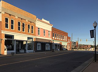
Albemarle is a city in and the county seat of Stanly County, North Carolina, United States. The population was 15,903 in the 2010 census.
Norwood is a town in Stanly County, North Carolina, United States. The population was 2,379 at the 2010 census.
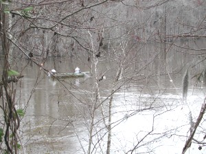
The Pee Dee River, also known as the Great Pee Dee River, is a river in the Carolinas of the United States. It originates in the Appalachian Mountains in North Carolina, where its upper course, above the mouth of the Uwharrie River, is known as the Yadkin River. The river empties into Winyah Bay, and then into the Atlantic Ocean near Georgetown.

The Yadkin River is one of the longest rivers in the US state of North Carolina, flowing 215 miles (346 km). It rises in the northwestern portion of the state near the Blue Ridge Parkway's Thunder Hill Overlook. Several parts of the river are impounded by dams for water, power, and flood control. The river becomes the Pee Dee River at the confluence of the Uwharrie River south of the community of Badin and east of the town of Albemarle. The river then flows into South Carolina near Cheraw, which is at the Fall Line. The entirety of the Yadkin River and the Great Pee Dee River is part of the Yadkin-Pee Dee River Basin.

Morrow Mountain State Park is a state park in Stanly County, North Carolina, U.S. Located near Albemarle, the park includes 5,881 acres (23.80 km2) within the Uwharrie Mountains.

The Uwharrie River () is a 61.84 mi (99.52 km) long river, in the Piedmont region of central North Carolina in the United States. It is a tributary of the Pee Dee River, which flows to the Atlantic Ocean.

The Tuckertown Reservoir is the reservoir formed by the Tuckertown Dam35°29′05″N80°10′36″W at the North end of Badin Lake and the High Rock Dam 35°36′03″N80°14′06″W at the bottom of High Rock Lake in the Uwharrie Lakes Region in the U.S. state of North Carolina.

Lake Tillery is a reservoir between Falls Reservoir and Blewett Falls Lake in the Uwharrie Lakes Region of North Carolina. It is entirely within Stanly County and Montgomery County, NC. The lake was created by impounding the Pee Dee River, which is created by the confluence of the Yadkin River and the Uwharrie River several miles to the north. Norwood, NC in neighboring Stanly County uses as its town motto "Gateway to Lake Tillery".

The Uwharrie Lakes Region of North Carolina in the United States refers to the lakes created by the damming of the Yadkin and Pee Dee rivers along the western slopes of the ancient Uwharrie Mountains.

High Rock Lake is a reservoir located on the Yadkin River in central North Carolina in the counties of Davidson and Rowan. Built in 1926-27 by the Tallassee Power Company, a wholly owned subsidiary of the Aluminum Company of America (Alcoa), the lake is the northernmost of a series of four hydroelectric projects designed at the time to support the company’s Badin Works, a large aluminum smelting operation located 16 miles downstream in the community of Badin. After the permanent closing of the Badin Works in 2007, Alcoa continued to operate its Yadkin hydroelectric facilities until selling them to Cube Hydro Carolinas in 2016.

North Carolina Highway 27 (NC 27) is a primary state highway in the U.S. state of North Carolina. The route traverses 198 miles (319 km) through southern and central North Carolina, about 100 miles (160 km) of it as a concurrency with NC 24.
Blewett Falls Lake is a reservoir located in Anson and Richmond counties in the U.S. state of North Carolina. No bridges span the lake. It is a major lake in the Uwharrie Lakes Region and the southernmost and widest body in this chain of lakes. Created by the damming of the Great Pee Dee River, the lake occupies the former Blewett Falls on that river, which were named after an early local family. The lake was created for hydropower in the early 20th century.

Uwharrie National Forest is a federally designated national forest region located primarily in Montgomery County, but also extending into Randolph and Davidson counties in south central North Carolina. It is the smallest of the four National Forests in North Carolina, with a total area of 50,645 acres (204.95 km2). About 79% of its acreage is in Montgomery County. The forest is managed together with the other three North Carolina National Forests from common headquarters in Asheville, North Carolina. However, it does have a local ranger district office in Troy, North Carolina. There is one officially designated wilderness area within the forest—the 5,025-acre (20.34 km²) Birkhead Mountains Wilderness.

The Yadkin–Pee Dee River Basin is a large river basin in the eastern United States, covering around 7,221 square miles, making it the second largest in the state of North Carolina. Its headwaters rise near Blowing Rock, North Carolina, and the basin drains to the Atlantic Ocean in Winyah Bay, east of Georgetown, South Carolina.
Alcoa Power Generating, Inc. is a subsidiary of Alcoa Inc., headquartered in Pittsburgh, Pennsylvania. Its three divisions were independent subsidiaries before being consolidated into Alcoa Power Generating, Inc. (APGI). These three projects have produced hydroelectric power and manage impoundments which also provide flood control; recreation, residential and business opportunities; and wildlife habitat.

The James B. Garrison Bridge are two automobile bridges spanning the Pee Dee River/Lake Tillery, between Stanly and Montgomery Counties. The bridges carry NC 24/NC 27/NC 73.

Barringer Township is a non-functioning township in Iredell County, North Carolina, United States. By the requirements of the North Carolina Constitution of 1868, the counties were divided into townships, including sixteen in Iredell County.


