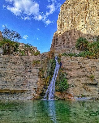
Balochistan is a province of Pakistan. Located in the southwestern region of the country, Balochistan is the largest province of Pakistan by land area but is the least populated one. It is bordered by the Pakistani provinces of Khyber Pakhtunkhwa to the north-east, Punjab to the east and Sindh to the south-east; shares international borders with Iran to the west and Afghanistan to the north; and is bound by the Arabian Sea to the south. Balochistan is an extensive plateau of rough terrain divided into basins by ranges of sufficient heights and ruggedness. It has the world's largest deep sea port, the Port of Gwadar lying in the Arabian Sea.

The administrative units of Pakistan comprise four provinces, one federal territory, and two disputed territories: the provinces of Punjab, Sindh, Khyber Pakhtunkhwa, and Balochistan; the Islamabad Capital Territory; and the administrative territories of Azad Jammu and Kashmir and Gilgit–Baltistan. As part of the Kashmir conflict with neighbouring India, Pakistan has also claimed sovereignty over the Indian-controlled territories of Jammu and Kashmir and Ladakh since the First Kashmir War of 1947–1948, but has never exercised administrative authority over either region. All of Pakistan's provinces and territories are subdivided into divisions, which are further subdivided into districts, and then tehsils, which are again further subdivided into union councils.
The history of Balochistan refers to the history of the Balochistan region of Pakistan, Iran and Afghanistan. Vague allusions to the region were found in Greek historical records of around 650 BCE. Prehistoric Balochistan dates to the Paleolithic.
Khuzdar is the capital city of the Khuzdar District in the central part of the Balochistan province of Pakistan. Khuzdar is the 3rd-largest city of the Balochistan province and the 48th-largest city of Pakistan by population according to the 2017 census. Historically, Khuzdar was the main city and capital of the Jhalawan province of the Khanate of Kalat. From October 1952 to 1955, it became part of the Balochistan States Union. In 1955, Khuzdar became the capital of the newly formed Kalat Division. Currently, it is the largest Brahui-speaking city.

The State of Kharan was an autonomous princely state in British India covering what is part of the present-day province of Balochistan, in the southwest of Pakistan.

The former administrative units of Pakistan are states, provinces and territories which mainly existed between 1947 and 1975 when the current provinces and territories were established. The former units have no administrative function today but some remain as historical and cultural legacies. In some cases, the current provinces and territories correspond to the former units – for example the province of Punjab includes almost all the territory of the former province of West Punjab.

The Chief Commissioner's Province of British Baluchistan was a province of British India established in 1876. Upon the creation of Pakistan it acceded to the newly formed state. It was part of the Baluchistan Agency. It was dissolved to form a united province of West Pakistan in 1955 upon the creation of One Unit Scheme.

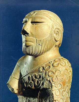
The Khanate of Kalat was a Brahui Khanate that originated in the modern-day Kalat region of Pakistan. Formed in 1666 due to the threat of Mughal expansion in the region, it controlled the wider Balochistan at its greatest extent in the mid-18th century, extending from Kerman in the west to Sindh in the east and from Helmand river in the north to the Arabian sea in the south. Khanate of Kalat lost considerable area to Qajar Iran and Emirate of Afghanistan in the early 19th century, and the city of Kalat was itself sacked by the British in 1839. Kalat became a self-governing state in a subsidiary alliance with British India after the signature of the Treaty of Kalat by the Khan of Kalat and the Baloch Sardars in 1875, and the supervision of Kalat became task of the Baluchistan Agency. Kalat was briefly independent from 12 August 1947 until 27 March 1948, when its ruler Ahmad Yar Khan acceded to Pakistan, making it one of the Princely states of Pakistan.

Las Bela was a princely state in a subsidiary alliance with British India which existed until 1955. The state occupied an area of 18,254 km2 (7,048 sq mi) in the extreme southeast of the Balochistan region, with an extensive coastline on the Arabian Sea to the south. Las Bela was bordered by the princely states of Kalat and Makran to the north and west. To the east lay the province of Sind and to the southeast lay the Federal Capital Territory around the city of Karachi.

Makran was an autonomous princely state in a subsidiary alliance with British India until 1947, before being absorbed as an autonomous princely state of Pakistan. It ceased to exist in 1955. It was located in the extreme southwest of present-day Pakistan, an area now parts of the districts of Gwadar, Kech and Panjgur. The state did not include the enclave of Omani Gwadar, which was under Omani rule until 1958.

The four provinces, capital territory, and two autonomous territories of Pakistan are subdivided into 39 administrative "divisions", which are further subdivided into districts, tehsils, and finally union councils. These divisions were abolished in 2000, but restored in 2008.

The Insurgency in Balochistan is an insurgency or revolt by Baloch nationalists and Islamist militants against the governments of Pakistan and Iran in the Balochistan region, which covers the Pakistani province of Balochistan, Iranian province of Sistan and Baluchestan Province in southeastern Iran, and the Balochistan region of southern Afghanistan. Rich in natural resources like natural gas, oil, coal, copper, sulphur, fluoride and gold, this is the largest, least populated and least developed province in Pakistan. Armed groups demand greater control of the province's natural resources and political autonomy. Baloch separatists have attacked civilians from other ethnicities throughout the province. In the 2010s, attacks against the Shia community by sectarian groups—though not always directly related to the political struggle—have risen, contributing to tensions in Balochistan. In Pakistan, the ethnic separatist insurgency is low-scale but ongoing mainly in southern Balochistan, as well as sectarian and religiously motivated militancy concentrated mainly in northern and central Balochistan.
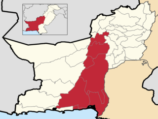
Kalat Division or Qalat Division is an administrative division of Balochistan Province of Pakistan. Its capital city is Khuzdar. The area of Kalat Division is 140,612 km².
The Baluchistan Agency was one of the agencies of British India during the colonial era. It was located in the present-day Pakistani Balochistan province.
Balochistan is a historical region in Western and South Asia, located in the Iranian plateau's far southeast and bordering the Indian Plate and the Arabian Sea coastline. This arid region of desert and mountains is primarily populated by ethnic Baloch people.

Jhalawan was an administrative division of the Khanate of Kalat, a princely state of Brahui that acceded to Pakistan in 1947. It was established in the 17th century and its boundary was fixed with Sindh in 1853. It was located in the southeastern part of Kalat State, north of Las Bela, west of the Kachi and Sindh and east of the Kharan and Makran.

Lasbela District is a coastal district of Balochistan province of Pakistan. It is also called Sassi-Punnu Garh among locals.

The princely states of Pakistan were princely states of the British Indian Empire which acceded to the new Dominion of Pakistan between 1947 and 1948, following the partition of British India and its independence.

Khan Mir Sir Ahmad Yar Khan Ahmedzai (1902–1979), commonly referred to as Yar Khan, was the last Khan of Kalat, a princely state in a subsidiary alliance with British India and the Dominion of Pakistan, serving from 10 September 1933 to 14 October 1955.