Banyuwangi Regency

Last updated
Banyuwangi Regency
Kabupaten Banyuwangi
Blambangan
Other transcription(s)
   Osing ꦑꦧꦸꦥꦠꦺꦤ꧀ꦨꦪꦸꦮꦔꦶ
Kawah Ijen (27432832286).jpg
Banyuwangi Regency coat of arms.svg
Motto(s): 
ꦯꦠꦾꦨꦏ꧀ꦠꦶꦦꦿꦗꦩꦸꦏ꧀ꦠꦶ (official)
Satya Bhakti Praja Mukti
(devoted to the truth for the welfare of the people)

The Sunrise of Java (informal)
Locator kabupaten banyuwangi.png
Location within East Java
Java location map plain.svg
Red pog.svg
Banyuwangi Regency
Location in Java and Indonesia
Indonesia location map.svg
Red pog.svg
Banyuwangi Regency
Banyuwangi Regency (Indonesia)
Coordinates: 8°13′07″S114°22′01″E / 8.21861°S 114.36694°E / -8.21861; 114.36694
Country Flag of Indonesia.svg  Indonesia
Province Flag of East Java.svg  East Java
Anniversary18 December 1771
Capital Banyuwangi
Government
  Regent Ipuk Fiestiandani
  Vice RegentH. Sugirah
Area
  Total5,782.40 km2 (2,232.60 sq mi)
Population
 (mid 2023 estimate)
  Total1,780,015
  Density310/km2 (800/sq mi)
  [1]
Time zone UTC+7 (IWST)
Area code (+62) 333
Website banyuwangikab.go.id

Banyuwangi Regency is a regency (Indonesian : kabupaten) of East Java province in Indonesia. This regency also known as the sun rise of Java because it is located at the easternmost end of Java Island. The town of Banyuwangi serves as a port for ferry services between Java and Bali. The regency is surrounded by mountains and forests to the west; by sea to the east and south - is separated by the Strait of Bali from Bali. With an area of 5,782.5 km2, this regency is by far the largest on the island of Java. The regency is a tourist destination, and subject to ongoing development as an international tourist destination with relevant infrastructure. [2] Banyuwangi regency has been declared a taman bumi (earth park), or national geological park (Geopark) in 2018. [3]

Contents

It had a population of 1,488,791 according to the 2000 Census; by the 2010 Census it had risen to 1,556,078; [4] and at the 2020 Census to 1,708,114; [5] the official estimate as at mid 2023 was 1,780,015 (comprising 888,288 males and 891,727 females). [1] The town of Banyuwangi is the administrative capital. The name Banyuwangi is Javanese for "fragrant water", connected to the Javanese folklore of Sri Tanjung.

Society and history

View of Banyuwangi during colonial period COLLECTIE TROPENMUSEUM Gezicht op Banjoewangi Oost-Java TMnr 60020438.jpg
View of Banyuwangi during colonial period

One Banyuwangi native group is the Osing community which has a Hindu culture although they can be considered as a Javanese sub-ethnic group. They live mainly in the central part of Banyuwangi and they sometimes consider themselves as Majapahit descendants. [ citation needed ] Other groups are Javanese (living mostly in the south and west), Madurese (mainly in the north and coastal area) and Balinese (scattered but more concentrated in the east). Other smaller groups include Chinese, Buginese, and Arabs.

Once known as Blambangan (or its variation: Balambangan and Balumbungan), it was a vassal of the Majapahit Kingdom and a regional trade centre. Blambangan's autonomy grew considerably after the end of 14th century A.D. After the Majapahit Kingdom ceased to exist, it became an independent kingdom and, as such, the last Hindu kingdom of Java. In order to defend itself from the troops of the Sultanate of Demak, which tried to occupy it, Blambangan asked for help from Balinese kings, which caused it to lose its independence to Balinese kingdoms. During this time Blambangan was deeply influenced by Balinese culture. After around 150 years of Balinese occupation, the Sultanate of Mataram gained control of the territory and renamed it Banyuwangi. Tawang alun II of Balmbangan freed Balmbangan from Mataram sultanate during Trunojoyo revolt and built the capital of Macan Putih , near modern day Banyuwangi . Later, it was part of the Mataram territory controlled by the VOC (1770). During the expansion of plantations in the 19th century, many parts of Banyuwangi were planted with coffee and sugar cane, which feature its landscape even now. The Chinese and Arabs came mostly during this period.

Banyuwangi people are known for their combination of Islamic and pre-Islamic tradition.

During the Fall of Suharto, a witchhunt in Banyuwangi against alleged sorcerers spiraled into widespread riots and violence. In addition to alleged sorcerers, Islamic clerics were also targeted and killed, Nahdlatul Ulama members were murdered by rioters. [6] [7]

Culture

The Blambangan Peninsula is one of the remaining places in Java where Hindu culture is still retained, having a Balinese influence.

Gandrung Dance

This is a Banyuwangi-typical dance which performed by a woman and along with simple music like violin, triangle (called kluncing), gong (or kempul), kendhang and sometimes with keyboard as result of modern influence. It is performed during night until dawn particularly in parties.

Janger or Damarwulan

Damarwulan is a legendary hero who features in traditional theatre art which has been developed since the 19th century in Banyuwangi. It is a combination of Balinese, Javanese and local cultures. Balinese influences can be seen in its performers' costumes and instruments. Meanwhile, Javanese influences is in its "lakon" or stories as well as language in dialogues. It is distinct from the Balinese Janger.

Administrative districts

Administration of Banyuwangi Regency Indonesia Banyuwangi Regency location map.svg
Administration of Banyuwangi Regency

At the time of the 2010 Census, Banyuwangi Regency was divided into twenty-four districts [8] (Indonesian : kecamatan), but an additional district - Blimbingsari - was subsequently created on 9 January 2017 from part of Rogojampi District. The twenty-five districts are listed below with their areas [1] and their populations at the 2020 Census [4] and the 2020 Census, [5] together with the official estimates as at mid 2022. [9] The table also includes the locations of the district administrative centres, the number of villages in each district (totaling 189 rural desa and 28 urban kelurahan), and its postal codes.

Kode
Wilayah
Name of
District
(kecamatan)
Area
in
km2
Pop'n
Census
2010
Pop'n
Census
2020
Pop'n
Estimate
mid 2022
Admin
centre
No.
of
villages
Post
codes
35.10.01Pesanggaran (a)802.5048,41253,37354,117Sumberagung568488
35.10.22Siliragung95.1544,39048,67849,331Siliragung568489
35.10.02Bangorejo137.4359,44265,70966,642Kebondalem768487
35.10.03Purwoharjo (b)200.3064,96969,47170,231Purwoharjo868483
35.10.04Tegaldlimo1,341.1261,17666,73767,598Tegaldlimo968484
35.10.05Muncar146.07128,924136,425137,778Blambangan1068472
35.10.06Cluring97.4470,04977,41778,515Cluring968482
35.10.07Gambiran66.7758,41266,18767,287Wringinagung668486
35.10.23Tegalsari65.2346,16152,36153,237Tegalsari668485
35.10.10 Glenmore 421.9869,47175,36576,296Karangharjo768466
35.10.11Kalibaru406.7661,18265,14265,827Kalibaruwetan668467
35.10.09Genteng82.3483,12392,44893,816Gentang Wetan568465
35.10.08Srono100.7787,20996,91498,339Sukomaju1068471
Totals of
southern
two-thirds
3,963.86882,920966,227979,01493
35.10.13Rogojampi48.5192,35857,21758,529Rogojampi1068462
35.10.25Blimbingsari67.13(c)54,34155,587Blimbingsari1068460 & 68461
35.10.14Kabat94.1767,13763,41363,692Kabat1468461
35.10.12Singojuruh59.8945,24250,46351,223Singojuruh1168464
35.10.20Sempu174.8371,28183,10084,714Sempu768468
35.10.19Songgon301.8450,27557,07758,037Tegalarum968463
35.10.15Glagah76.7533,99236,53236,950Glagah10 (d)68431 & 68432
35.10.24 Licin 169.2527,87829,46029,748Licin868454
35.10.16 Banyuwangi
(town)
(e)
30.13106,000117,558119,265Tukangkayu18 (f)68411 - 68419
35.10.17Giri21.3128,51031,62132,080Mojopanggung6 (g)68422 - 68425
35.10.21Kalipuro310.0376,17883,68584,822Kalipuro9 (h)68421 - 68455
35.10.18Wongsorejo (i)464.8074,30777,42078,070Wongsorejo1268453
Totals of
northern third
1,818.64673,158741,887752,717124
Totals5,782.501,556,0781,708,1141,731,731 Banyuwangi (town) 217

Note: (a) included 10 small offshore islands. (b) includes small offshore islands of Pulau Parengan and Pulau Watulayar.
(c) The 2010 population of the new Blimbingsari District is included in the figure for Rogojampi District from which it was cut out.
(d) including 2 urban kelurahan (Bakungan and Banjarsari). (e) includes small offshore islands of Pulau Boom and Pulau Santen.
(f) all 18 are kelurahan (Kampung Mandar, Kampung Melayu, Karangrejo, Kebalenan, Kepatihan, Kertosari, Lateng, Pakis, Panderejo, Penganjuran, Pengantigan, Singonegaran, Singotrunan, Sobo, Sumber Rejo, Taman Baru, Temenggungan and Tukang Kayu).
(g) comprises 4 kelurahan (Boyolangu, Giri, Mojopanggung and Penataban) and 2 desa. (h) comprises 4 kelurahan (Bulusan, Gombengsari, Kalipuro and Klatak) and 5 desa.
(i) includes small offshore island of Pulau Tabuan.

Transportation

Banyuwangi International Airport at Blimbingsari serves the regency, Banyuwangi city and surrounding area of East Java. Banyuwangi can be reached by road and rail from Surabaya or by ferry from Bali.

Tourism

Reede on Bali Street, Banjuwangi, East Java COLLECTIE TROPENMUSEUM Reede en Straat Bali Banjuwangi Oost-Java TMnr 10022091.jpg
Reede on Bali Street, Banjuwangi, East Java

Many European tourists visiting Bali come to Banyuwangi to surf in Plengkung and dive in Tabuhan Island. Ferries from Bali arrive at the port of Ketapang, some 8 km to the north of Banyuwangi city. Plekung Beach is also known as G-Land or green land have 3 types of waves up to 6 to 8 meters tall. [10]

Banyuwangi International Surfing Competition 2014

This was the second time competition after the 2012 competition. 23–25 May 2014 competition is followed by at least 15 countries in Pantai Pulau Merah (Red Island Beach) which has 4 meters height and 400 meters long of waves. [11]

Diamond Triangle

Diamond Triangle consists of: [12]

Waterfalls

Visitors may be interested to find several waterfalls in one locality. Opened formally in 2014, there are a number of waterfalls in Kampung Anyar (New Village), near Kalibendo Plantation, around 15 kilometers from Banyuwangi on the way to Mount Ijen. There are 3 waterfalls near to each other known as the "Triple Waterfall" to be found 10 minutes walk down the stairs from a parking area. Or about 300 meters along the river, walking uphill, Kethagen Waterfall can be found. The cliff besides the river can reflect sunlight, glittering like diamonds. [13]

Climate

Banyuwangi has a temperate tropical and wet dry climate, similar to Banyuwangi's dry season start from May until October, and the rest is wet season. in 2013, Banyuwangi's highest average temperature is on October with 28.2 °C and lowest average temperature is on April with 24.8 °C

Climate Data For Banyuwangi
Year2013
MonthJanFebMarAprMayJuneJulyAugSeptOctNovDec
Av. High (Celsius)31.732.33231.731.530.329.629.430.132.531.931.7
Daily (Celsius)26.727.727.424.827.52726.12626.328.227.427.2
Av. Low (Celsius)24.124.724.324.824.724.424.623.323.624.724.624.4
AV. Rainfall (mm)527.5100.2193.1228.897.3122.815637.36.90.8237.6160.3
Av. Rainy Days251419161618198442121
Source: [14] [15]
Wind Speed and Humidity
MonthJanFebMarAprMayJunJulAugSepOctNovDec
Wind Speed (Knot)3.13.23.23.13.22.6332.83.12.32.1
Humidity (%)868182838486827877758283
Source: [16]
Air Pressure and Sunlight Exposure
MonthJanFebMarAprMayJunJulAugSepOctNovDec
Air Pressure (mb)1008.71008.31010.21004.21010.21009.21011.51012.81012.81012.41009.51008.8
Sunlight Exposure457172677058608796996761
Source: [17]

Environment

The forest and river in Banyuwangi is well-preserved, says the Indonesia Dragonfly Society because they found 3 dragonfly species which only can live in good environment. [18]

Nevertheless, there are local controversies in the Regency over the impact of gold mining activities in the locality of Tumpang Pitu village. In 2006, the Banywangi regency administration granted a mining licence to one company, PT Indo Multi Niaga, which later transferred the licence to another company. However, the local community had expressed concern about gold mining activities as early as 1997. The issues partly related to the protection of the area around a local Hindu temple, partly relate to environmental matters, and partly related to local community views about the economic and social impact of the mining. [19] In addition, in Banyuwangi town, Kertosari kelurahan has a Multimedia training center for Vocational High Schools (Vocational High Schools) in Industrial Work Practices in the field of Television, through a place where millennials are creative who are members of Misntv (Media Inspirasi Sahabat Nusantara Televisi). This media is a Media Streaming Network, under the auspices of Mav Entertainment Corporation and Lembaga Sahadat-Qu, which aims to create a new workforce in the field of Television and Journalism that is reliable. The location of the Misntv office is on Jl. Ikan Banyar No. 91 RT. 03 RW. 03 Krajan Kertosari. Hopefully with this training center it can improve the economy at the UMKM level and the younger generation is able to compete in the digital era. Online Access via YouTube Misntv and Mav Entertainment Corporation

Related Research Articles

<span class="mw-page-title-main">Osing people</span> Ethnic group in Indonesia

The Osing or Using are indigenous ethnic group native to easternmost part of the Java island, Indonesia. They are the descendants of the people of the ancient Kingdom of Blambangan. The population of Osing people are approximately 400,000 which concentrated in the Banyuwangi Regency of East Java Province.

<span class="mw-page-title-main">Mataram (city)</span> City and capital of West Nusa Tenggara, Indonesia

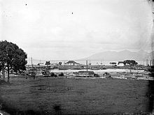
Mataram is a city and the capital of the Indonesian province of West Nusa Tenggara. The city is surrounded on all the landward sides by West Lombok Regency and lies on the western side of the island of Lombok, Indonesia. It is also the largest city of the province, and had a population of 402,843 at the 2010 Census and 429,651 at the 2020 Census; the official estimate as at mid 2023 was 441,147.

<span class="mw-page-title-main">Cilacap Regency</span> Regency of Indonesia

Cilacap Regency is a regency in the southwestern part of Central Java province in Indonesia. Its capital is the town of Cilacap.

<span class="mw-page-title-main">Bondowoso Regency</span> Regency of Indonesia

Bondowoso Regency is a landlocked regency in East Java, Indonesia. It covers an area of 1,560.10 km2, and had a population of 736,772 at the 2010 Census and 776,151 at the 2020 Census; the official estimate as of mid-2023 was 796,911. The most common languages are Madurese and Javanese, although Madurese is the majority. The nearest large city is Surabaya, approximately five hour's drive away.

<span class="mw-page-title-main">Mojokerto</span> City in East Java, Indonesia

Mojokerto is a city in East Java Province of Indonesia. It is located 40 km southwest of Surabaya, the provincial capital, and constitutes one of the component units of the Surabaya metropolitan area which comprises Gresik Regency, Bangkalan Regency, Mojokerto Regency, Mojokerto City, Surabaya City, Sidoarjo Regency, and Lamongan Regency. The city covers an area of 20.21 km2, and had a population of 120,196 at the 2010 census and 132,434 at the 2020 Census; the official estimate as of mid-2023 was 141,785.

<span class="mw-page-title-main">Jember Regency</span> Regency of Indonesia

Jember Regency is a regency of East Java province, in Indonesia. The land area is 3,314.13 km2, and the population was 2,332,726 at the 2010 census and 2,536,729 at the 2020 Census; the official estimate as at mid 2023 was 2,600,663. Its administrative capital is the urban area of Jember, which with 366,932 inhabitants in mid 2023 is the third largest urban area in East Java province but does not have municipality or city status as it is split between three separate administrative districts (kecamatan). Jember is famous for its tobacco farms and traditional food called tape which is made of fermented cassava.

<span class="mw-page-title-main">Situbondo Regency</span> Regency of Indonesia

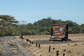
Situbondo Regency is a regency (kabupaten) in the east of East Java province, Indonesia. It covers an area of 1,658.03 km2, and had a population of 647,619 at the 2010 Census and 685,967 at the 2020 Census; the official estimate as at mid 2023 was 684,343. It is located towards the eastern end of Java, before Banyuwangi. The administrative centre is Situbondo, a small town within the regency. One of the famous tourist sites is Baluran National Park.

<span class="mw-page-title-main">Klungkung Regency</span> Regency of Indonesia

Klungkung Regency is the smallest regency (kabupaten) in the island province of Bali, Indonesia. It has an area of 315 km2 and had a population at the 2010 Census of 170,543 which increased to 206,925 at the Census of 2020; the official estimate as at mid 2022 was 214,012. The administrative centre for the regency is in the town of Semarapura.

<span class="mw-page-title-main">Buleleng Regency</span> Regency in Bali, Indonesia

Buleleng is a regency of Bali Province, Indonesia. It stretches along the north side of the island of Bali from the Bali Strait in the west almost to the eastern end of the island. It has an area of 1,365.88 km2 and a population of 624,125 at the 2010 census and 791,910 at the 2020 census; the official estimate as of mid-2022 was 825,141. Its regency seat is in the town of Singaraja.

<span class="mw-page-title-main">Malang Regency</span> Regency in Indonesia

Malang Regency is the second largest regency in East Java, Indonesia, with a total area of 3,530.65 km (2,193.84 mi). It is rich in potential for agriculture, medicinal plants and tourism.

<span class="mw-page-title-main">Batang Regency</span> Regency of Indonesia

Batang is a regency on the north coast of Central Java province in Indonesia. It covers an area of 788.64 km2 and had a population of 706,764 at the 2010 Census and 801,718 at the 2020 Census; the official estimate as of mid-2022 was 817,100. Its capital is the town of Batang, about 100 km west of the province's capital city of Semarang.

<span class="mw-page-title-main">Selayar Islands Regency</span> Regency in Sulawesi, Indonesia

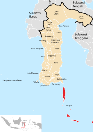
The Selayar Islands Regency is a regency of Indonesia in South Sulawesi province that covers the Selayar Islands, which lie southeast of the southern peninsula of Sulawesi. The archipelago consists of the group's main island, which is surrounded by 41 smaller islands around its coast; further to the southeast lies a widespread group of islands, including the huge atoll of Takabonerate. The regency covers an area of 1,357.03 km2, and had a population of 103,596 at the 2000 Census, 122,055 at the Census of 2010 and 137,071 at that of 2020. The official estimate for mid 2022 was 139,145. The administrative centre is the town of Benteng on Selayar Island. The Selayar Straits separate the regency from Sulawesi island.

<span class="mw-page-title-main">Demak Regency</span> Regency of Indonesia

Demak is a regency located in the Indonesian province of Central Java, on the northern coast of the island. It is bordered by Jepara Regency and the Java Sea to the north, Kudus and Grobogan Regencies to the east, Grobogan and Semarang Regencies to the south, while to the west are Semarang Regency and the city of Semarang, to which the districts of Mranggen and Sayung within Demak Regency are essentially suburban. The regency covers an area of 995.32 km2 (384.30 sq mi) and had a population of 1,055,579 at the 2010 Census and 1,203,956 at the 2020 Census; the official estimate as at mid 2022 was 1,223,217. It was originally the centre of the Demak Sultanate, once a dominant power in the region. Due to its strong relation with the spread of Islam in Java and the Wali Sanga, it is sometimes referred to with the nickname Kota Wali.

<span class="mw-page-title-main">Sarmi Regency</span> Regency in Papua, Indonesia

Sarmi Regency is one of the regencies (kabupaten) in Papua Province of Indonesia. It was formed from the western districts which had until then been part of Jayapura Regency with effect from 12 November 2002. It covers an area of 18,034.0 km2, and had a population of 32,971 at the 2010 Census and 41,515 at the 2020 Census; the official estimate as at mid 2022 was 42,233. The regency's administrative centre is at the town of Sarmi.

<span class="mw-page-title-main">Yapen Islands Regency</span> Regency in Papua, Indonesia

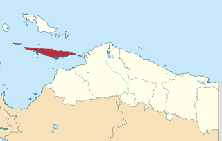
Yapen Islands Regency is a regency (kabupaten) in Papua Province of eastern Indonesia. It covers an area of 2,432.49 km2 (939.19 sq mi), and had a population of 82,951 at the 2010 Census and 112,676 at the 2020 Census; the official estimate as at mid 2022 was 116,107. It comprises an archipelago which lies in Cenderawasih Bay off the north coast of Western New Guinea.

<span class="mw-page-title-main">Kaimana Regency</span> Regency in West Papua, Indonesia

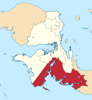
Kaimana Regency is a regency in the south of West Papua province of Indonesia. It covers an area of 18,500 sq. km, and had a population of 46,249 at the 2010 Census and 62,256 at the 2020 Census; the official estimate as at mid 2022 was 63,633. The administrative centre is the town of Kaimana. The Mairasi languages are spoken in the regency, among other languages.

<span class="mw-page-title-main">Manokwari Regency</span> Regency in West Papua, Indonesia

Manokwari Regency is a regency in West Papua, Indonesia. Following the splitting away of twenty of its former districts in 2013, it now covers an area of 3,168.28 km2 and had a population of 192,663 at the 2020 Census; the official estimate as at mid 2022 was 200,785. The administrative centre is presently at the town of Manokwari, which is also the capital of the province, but under proposals currently under consideration by the Indonesian Parliament, the town is intended to be split off from the regency to form a separate independent city.

<span class="mw-page-title-main">Karangasem Regency</span> Regency in Indonesia

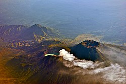
Karangasem Regency is a regency (kabupaten) of the island and province of Bali, Indonesia. It covers the east part of Bali, has an area of 839.54 km2 and had a population of 396,487 at the 2010 Census which rose to 492,402 at the 2020 Census; the official estimate as at mid 2022 was 511,300. Its regency seat is the town of Amlapura. Karangasem was devastated when Mount Agung erupted in 1963, killing 1,900 people. Karangasem was a kingdom before Bali was conquered by the Dutch.

<span class="mw-page-title-main">Banyuwangi (town)</span> Town and Capital of Banyuwangi Regency, Indonesia

Banyuwangi, previously known as Banjoewangi, is the administrative capital of Banyuwangi Regency at the far eastern end of the island of Java, Indonesia. It had a population of 106,000 at the 2010 census and 117,558 at the 2020 census.

<span class="mw-page-title-main">Bali Kingdom</span> Series of kingdoms in Bali, Indonesia

The Kingdomship of Bali was a series of Hindu-Buddhist kingdoms that once ruled some parts of the volcanic island of Bali, in Lesser Sunda Islands, Indonesia. With a history of native Balinese kingship spanning from the early 10th to early 20th centuries, Balinese kingdoms demonstrated sophisticated Balinese court culture where native elements of spirit and ancestral reverence combined with Hindu influences—adopted from India through ancient Java intermediary—flourished, enriched and shaped Balinese culture.

References

  1. 1 2 3 Badan Pusat Statistik, Jakarta, 28 February 2024, Kabupaten Banyuwangi Dalam Angka 2024 (Katalog-BPS 1102001.3510)
  2. "Indonesia announces 10 new destination brands". The Jakarta Post. Retrieved 11 August 2019.
  3. "Banyuwangi regency declared national geopark area". The Jakarta Post. Retrieved 11 August 2019.
  4. 1 2 Biro Pusat Statistik, Jakarta, 2011.
  5. 1 2 Badan Pusat Statistik, Jakarta, 2021.
  6. "The Banyuwangi murders". Inside Indonesia. Retrieved 2020-06-03.
  7. Time. October 19, 1998 http://content.time.com/time/world/article/0,8599,2053925,00.html.{{cite magazine}}: Missing or empty |title= (help)
  8. "Banyuwangi Resmi Punya 25 Kecamatan" (in Indonesian). Regency government of Banyuwangi. Retrieved 9 January 2017.
  9. Badan Pusat Statistik, Jakarta, 28 February 2023, Kabupaten Banyuwangi Dalam Angka 2023 (Katalog-BPS 1102001.3510)
  10. "Pantai Plekung, Destinasi untuk Berselancar". October 17, 2011. Archived from the original on 2011-10-18.
  11. "Puluhan Peselancar Mancanegara Ikuti Kompetisi Surfing di Banyuwangi". May 17, 2014.
  12. "Triangle Diamond Banyuwangi". Archived from the original on December 6, 2013. Retrieved November 3, 2013.
  13. Agoes Santoso. "Segarnya Air Terjun Kembar Kampung Anyar" . Retrieved January 31, 2015.
  14. "BPS Kabupaten Banyuwangi". banyuwangikab.bps.go.id. Archived from the original on 2016-04-23. Retrieved 2016-04-12.
  15. "BPS Kabupaten Banyuwangi". banyuwangikab.bps.go.id. Archived from the original on 2016-04-23. Retrieved 2016-04-12.
  16. "BPS Kabupaten Banyuwangi". banyuwangikab.bps.go.id. Archived from the original on 2016-04-23. Retrieved 2016-04-12.
  17. "BPS Kabupaten Banyuwangi". banyuwangikab.bps.go.id. Archived from the original on 2016-04-23. Retrieved 2016-04-12.
  18. Ika Ningtyas (January 30, 2014). "Rare Dragonfly Species Found in Banyuwangi".
  19. Indra Harsaputra, 'Banyuwangi mining site risks triggering social conflight: Experts', The Jakarta Post, 30 January 2016

Wikivoyage-Logo-v3-icon.svg Banyuwangi travel guide from Wikivoyage

8°13′07″S114°22′01″E / 8.21861°S 114.36694°E / -8.21861; 114.36694