
Bondowoso Regency is a landlocked regency in East Java, Indonesia. It covers an area of 1,518.77 km2, and had a population of 736,772 at the 2010 Census and 776,151 at the 2020 Census; the official estimate as at mid 2022 was 781,417. The most common languages are Madurese and Javanese, although Madurese is the majority. The nearest large city is Surabaya, approximately five hours' drive away.

Wonosobo Regency is a regency in Central Java province in Indonesia. Its capital is the town of Wonosobo, located at 7.3684940°S 109.8983841°E, about 120 km from Semarang. The regency is located in the town of Wonosobo on the Dieng Plateau. Its area is 984.68 km2 and its population was 754,883 at the 2010 census and 879,124 at the 2020 census; the official estimate as at mid 2022 was 923,793.

Klaten Regency is a regency in Central Java province in Indonesia. It covers an area of 655.56 km2 and had a population of 1,130,047 at the 2010 Census and 1,260,506 at the 2020 Census; the official estimate as at mid 2022 was 1,275,850. Its capital is the town of the same name; the town extends over 33.73 km2 to encompass three of the regency's districts, with a combined total of 134,423 inhabitants in mid 2022; a fourth district (Kalikotes) is part of its urban area.

Magelang is a regency in Central Java, Indonesia, famous for its 9th century Buddhist temple of Borobudur. Its capital is Mungkid. It covers an area of 1,085.73 km2 and had a population of 1,181,723 at the 2010 Census and 1,299,859 at the 2020 Census; the official estimate as at mid 2022 was 1,312,573. These figures exclude the autonomous city of Magelang, which is separately administered but is geographically enclaved within the regency, which borders Temanggung Regency to the north, Semarang Regency to the northeast, Boyolali Regency to the east, the Special Region of Yogyakarta to the south and southeast, Purworejo Regency to the southwest, and Wonosobo Regency to the west. Its motto is Magelang Gemilang.

Bangkalan Regency is a regency of East Java province in Indonesia. The seat of its government is the town of Bangkalan. The regency is located on the west side of Madura Island, bordering with Sampang Regency to the east, Java Sea to the north and Madura Strait to the west and the south sides. It covers an area of 1,260.14 km2, and had a population of 906,761 at the 2010 census and reached 1,060,377 at the 2020 census; the official estimate as at mid 2022 was 1,086,620 – comprising 535,522 males and 551,098 females.

Lamongan Regency is a regency of East Java Province of Indonesia. It has a total land area of approximately 1,812.8 km2 (699.9 sq mi) or + 3.78% of the area of East Java Province. With a length of 47 km (29 mi) along the coastline, the sea area of Lamongan Regency is about 902.4 km2 (348.4 sq mi), if calculated to a distance of 12 miles (19 km) across the ocean surface. At the 2010 census it had a population of 1,179,059; the 2020 Census produced a total of 1,379,628 and the official estimate as at mid 2022 was 1,386,941. The regency seat is the town of Lamongan.

Nganjuk Regency is a regency (kabupaten) of East Java Province, Indonesia. It bordered Bojonegoro Regency in the north, Jombang Regency in the east, Kediri Regency in the south, and Madiun Regency in the west. It covers an area of 1,224.33 sq. km, and had a population of 1,017,030 at the 2010 Census and 1,103,902 at the 2020 Census; the official estimate as at mid 2022 was 1,117,033. The administrative centre of the regency is the town of Nganjuk. The current regent is Dr. Drs. H. Marhaen Djumadi, S.E., S.H., M.M., M.B.A.

Pamekasan Regency is a regency (kabupaten) of the province of East Java, Indonesia. It is located on Madura Island approximately 120 kilometres (75 mi) east of Surabaya, the provincial capital. The regency covers an area of 792.30 square kilometres (305.91 sq mi), and at the 2010 census it had a population of 795,918 ; at the 2020 census the total was 850,057 and the official estimate as at mid 2022 was 857,818 – comprising 420,612 males and 437,206 females. The administrative capital is the town of Pamekasan.
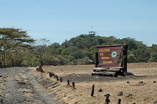
Situbondo Regency is a regency (kabupaten) of East Java province, Indonesia. It covers an area of 1,638.50 km2, and had a population of 647,619 at the 2010 Census and 685,967 at the 2020 Census; the official estimate as at mid 2022 was 673,102. It is located towards the eastern end of Java, before Banyuwangi. The administrative centre is Situbondo, a small town within the regency. One of the famous tourist sites is Baluran National Park.

Sumedang Regency is a landlocked regency (kabupaten) of West Java province, Indonesia. The district of North Sumedang is its capital. The regency covers an area of 1,558.72 km2, and had a population of 1,093,602 at the 2010 Census and 1,152,507 at the 2020 Census; the official estimate as at mid 2022 was 1,167,033.
Sukoharjo Regency is a regency in the Central Java province in Indonesia. It covers an area of 493.23 km2 and had a population of 824,238 at the 2010 Census and 907,587 at the 2020 Census; the official estimate as of mid-2022 was 916,627. Its capital is Sukoharjo, about 10 km south of Surakarta. This regency is bordered by the city of Surakarta in the north, Karanganyar Regency in the east, Wonogiri Regency and Yogyakarta in the south as well as Klaten Regency in the west. The regency is part of the metropolitan zone of Surakarta, which is known as Subosukawonosraten.

Balangan Regency is one of the regencies in the Indonesian province of South Kalimantan. It was created on 25 February 2003 from what were previously the eastern districts of North Hulu Sungai Regency. It now covers an area of 1,828.51 km2, and had a population of 112,430 at the 2010 Census and 130,355 at the 2020 Census; the official estimate as at mid 2022 was 134,512, consisting of 67,958 males and 66,554 females. The capital is Paringin. Motto: "Sanggam" (Banjarese), also an acronym for "Sanggup Bagawi Gasan Masyarakat".
Karanganyar Regency is a regency in the Indonesian province of Central Java. It covers an area of 767.79 km2 and had a population of 813,196 at the 2010 Census and 931,963 at the 2020 Census; the official estimate as of mid-2022 was 947,642. Its capital is the town of Karanganyar.
Rembang Regency is a regency on the extreme northeast coast of Central Java Province, on the island of Java in Indonesia. The regency covers an area of 1,036.70 km2 on Java, and it had a population of 591,359 at the 2010 Census and 645,333 at the 2020 Census; the official estimate as at mid 2022 was 650,770, of whom 327,196 were males and 323,574 were females. Its administrative capital is the town of Rembang.
Sragen Regency is a regency in the eastern part of Central Java province in Indonesia. It covers an area of 994.57 km2 and had a population of 858,266 at the 2010 Census and 976,951 at the 2020 Census; the official estimate as at mid 2022 was 992,243. Its capital is the town of Sragen, located about 30 km to the northeast of Surakarta. Sragen is bordered by East Java Province to the east.

East Kutai Regency is a regency of East Kalimantan province, Indonesia. It has an area of 35,747.50 km2 and had a population of 253,904 at the 2010 census and 434,459 at the 2020 census; the official estimate as at mid 2022 was 425,613. The town of Sangatta is the capital of the regency.
Kediri Regency is a regency (kabupaten) located in East Java province, Indonesia. It is one of two 'Daerah Tingkat II' that has the name 'Kediri'. The Regency covers an area of 1,523.92 km2 and had a population of 1,499,768 as of the 2010 census and 1,635,294 at the 2020 census; the official estimate as at mid 2022 was 1,656,020.
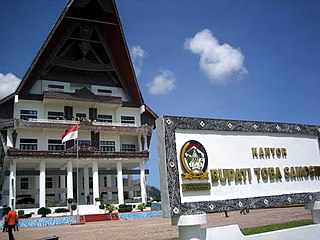
Toba Regency is a landlocked regency in North Sumatra. Its seat is Balige. The regency covers an area of 2,021.8 square kilometres; it had a population of 173,129 at the 2010 census and 206,199 at the 2020 Census; the official estimate as at mid 2022 was 212,133. It includes the eastern shore of the vast inland Lake Toba. The regency was formerly known as Toba Samosir Regency, until its name was officially shortened in 2020.
Sukamara Regency is one of the thirteen regencies which comprise the Central Kalimantan Province on the island of Kalimantan (Borneo), Indonesia. It was created on 10 April 2002 from the former southwest part of West Kotawaringin Regency. The town of Sukamara is the capital of Sukamara Regency, which covers an area of 3,827 km2. The population of the Regency was 44,952 at the 2010 Census and 63,464 at the 2020 Census; the official estimate as at mid 2022 was 66,845.

Lumajang Regency is a Regency (kabupaten) located in the East Java province of Indonesia. It covers an area of 1,790.90 sq. km, and had a population of 1,006,458 at the 2010 Census and 1,119,251 at the 2020 Census. The mid 2022 official estimate as originally stated to be 1,137,230, but was revised down to 1,097,504. The regency shares its land borders with Jember Regency, Probolinggo Regency, and Malang Regency, while it borders the Indian Ocean to the south.
Book "Apa dan Siapa Magetan", issued by Pemerintah Kabupaten Daerah Tingkat II Magetan, 1987


