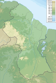
Barima-Waini is a region of Guyana and is located in the northwest of the country. Barima-Waini has three sub-regions: Mabaruma, Matakai, and Moruca.

Port Kaituma is a small village within the Barima-Waini administrative region of Guyana. It became known internationally as a gateway village to the Peoples Temple settlement in nearby Jonestown. It has long been a hub for mining in the area.
Matthews Ridge is a small village within the Barima-Waini administrative region of Guyana. The village name comes from the name of a public official, Matthew Young, as well as the ridges in the area. The village is divided into three sections, Heaven's Hill, Hell Hill and the valley.

Mabaruma is the administrative centre and regional capital for Region One (Barima-Waini) of Guyana. It is located close to the Aruka River on a narrow plateau above the surrounding rainforest at an elevation of 13 metres.
Ituni is a village in the interior of Guyana, at an altitude of 100 metres (331 feet). The area grew as a result of bauxite mining in the area.
Kwebanna is an Amerindian village in Barima-Waini region, in the north of Guyana. Kwebanna is connected by road to Kumaka, Barima-Waini.
Baramita, is a community in the Barima-Waini region of northern Guyana, standing about 20 miles west of Matthew's Ridge, at an altitude of 99 metres.
Hosororo is a community in the Barima-Waini region of northern Guyana, on the west bank of the Aruka River, 10 km (6.2 mi) from the river's mouth, and three miles from Mabaruma.

The Potaro River is a river in Guyana that runs from Mount Ayanganna area of the Pakaraima Mountains for approximately 255 km (158 mi) before flowing into the Essequibo River, Guyana's largest river. The renowned Kaieteur Falls is on the Potaro.

The Waini River is a river in the Barima-Waini region of northern Guyana. It flows into the Atlantic Ocean near the border with Venezuela. The upper portion of the river flows through the Guianian moist forests, while the lower Waini river flows through the eastern extent of the vast Orinoco Delta swamp forests before emptying into the sea.
The Siparuni River is a river in the Potaro-Siparuni Region of Guyana. It is a tributary of the Essequibo River. Tributaries of the Siparuni River include the Takutu River, Burro-Burro River, Tipuru River and Levai Creek.
Arakaka is a community in the Barima-Waini region of Guyana, standing on the Barima River and 12 miles southerly of Port Kaituma, at an altitude of 63 metres (209 feet).
The Konawaruk River is a river in Potaro-Siparuni, Guyana. About 60 miles long, it is a tributary of the Essequibo River, joining it just south of the Potaro River mouth at 5°18′N58°55′W.
The Kaituma River is a river of Guyana in the Barima-Waini region. The mouth is at the upper Barima River, and the area is made up of mostly mangrove swamps.
The Kako River is a river in the Cuyuni-Mazaruni region of Guyana and one of the largest tributaries of the Mazaruni River.
The Kuyuwini River is a river Guyana.
The Puruni River is a river of Guyana in the Cuyuni-Mazaruni region.
The Oko River is a river of Guyana, a tributary of the Wenamu River and a part of the middle-Mazaruni.
Issano is a village of Cuyuni-Mazaruni, Guyana. It's located along the Mazaruni River, and is a hub for mining.
Isseneru is an Amerindian settlement in the Cuyuni-Mazaruni region of Guyana, approximately 15–20 miles west of Kurupung.


